  
Watershed Report
North/West NYS With the Flow
Report for the Week of June 5 to June 11, 2023
Low flows continue
|
North – West NY Drainage Area
|
Low Flows
|
Impaired
Water
Bodies 303d list
|
Boil Water Advisories
|
HABs
|
Hazardous
Spills
|
|
Lake Ontario Tribs
|
1
|
56
|
0
|
1
|
1
|
|
Black River
|
2
|
34
|
0
|
0
|
3
|
|
Niagara River Lake Erie
|
5
|
49
|
1
|
2
|
8
|
|
Genesee River
|
3
|
23
|
0
|
0
|
4
|
|
Oswego River – Finger Lakes
|
3
|
40
|
0
|
0
|
8
|
|
Totals
|
14
|
202
|
1
|
3
|
24
|
Table updated June 12, 2023
Find your location in one of the five watersheds of the north-west drainage area of NYS to take note of the water bodies upstream and downstream of your location. Impacts to water occurring in this drainage area can impact local residents downstream of the incident site in the same watershed. For incidents involving highly mobile contaminants we expect to see downstream impacts on Lake Erie and/or Lake Ontario, which are sources of drinking water for many northeast USA and Canadian cities and towns.
Lake Ontario Minor Tributaries Watersheds
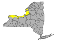
This watershed drains 2460 square miles of northwest New York State, including three sections of north and west NYS: areas that lie between the Niagara, Genesee, Oswego and Black River outlets. This watershed is divided into western, central and eastern sections that stretch all along the Lake Ontario Shoreline, including the Salmon River, Oak Orchard Creek, Irondequoit Creek, Sandy Creek; including Salmon River Reservoir, Sodus Bay, North Pond, Irondequoit Bay and Perch Lake. Flows in this watershed take runoff from most of Jefferson and Orleans Counties, parts of Monroe, Oswego, Wayne and Niagara Counties.
Western Section
Eighteenmile Creek drains an area of 84.8 sq miles in Niagara County. The flow at Burt is unrated, it is often around 100 cfs and 3 ft deep. This station has temperature and conductivity sensors.
Oak Orchard Creek drains an area of 202 sq miles in Orleans County. The flow
- near Shelby is unrated, around 270 cfs and 8 ft deep, temp and conductance are taken here
- at Kenyonville flow is unrated, around 350 cfs and 2.5 ft deep, with temp and conductance monitors here also
Central Section
Irondequoit Creek drains an area of 142 sq miles in Monroe County. The flow
- near Fishers flow is unrated, around 40 cfs and 4.5 ft deep
- above Blossom Rd. near Rochester normal flow is around 150 cfs and 3.5 ft deep, conductance is measured here
East Section
Northrup Creek drains an area of 10.1 sq miles in Monroe County. Normal flow at North Greece in Monroe County is around 8 cfs and 1.2 ft deep. Temperature is recorded here.
Sandy Creek drains an area of 137 sq miles in Jefferson County. Normal flow is 1.5 ft deep at around 100 cfs
North Branch Salmon River drains an area of 82.5 sq miles in Oswego County. The flow at Redfield is unrated – we see it around 110 cfs and 1.8 ft deep when nearby monitors are registering normal flows
Salmon River drains 238 sq miles in Oswego County. The flow at Pineville is unrated, we see this station at around 1000 cfs and 10 feet deep
Flows (1 low)
Irondequoit Creek is flowing much below normal above Blossom Rd near Rochester - down overnight - running 2.81 ft deep and 48 cubic feet per second
Impaired Water Bodies (56)
56 water bodies appear on the 2022 Draft 303(d) list for Lake Ontario and minor tributaries Watershed, up from six in the last list. Of the 56 total, 38 are affected by a proposed delisting in 2022, in whole or in part. For more details, check out the posted list under the NW tab.
Drinking Water Advisories (0)
HABs (1)
North Sandy Pond - widespread lake-wide bloom confirmed in Oswego County - reported by the public June 2
Spills (1)
-
June 6 - unknown amount of unknown petroleum reported spilled from Lineage Rolloff oil on State St in Brockport – Monroe
Black River Watershed
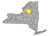
The Black River headwaters begin in the Adirondack mountains, scoop southwest and then curve northwest, the flow proceeds north-northwest, hooks west and empties into Lake Ontario. Major tributaries in the system include Moose River, Beaver River, Independence River and Deer River, Stillwater Reservoir, Fulton Chain of Lakes, Lake Lila and Big Moose Lake. Flows in this watershed take runoff from most of Jefferson and Lewis Counties along with parts of Herkimer, Hamilton, and Oneida Counties.
Black River drains an area of 1864 sq miles of Jefferson County. Normal flow
- near Boonville is around 1600 cfs and 6 feet deep (flood stage is 10ft)
- at Watertown normal flow is around 7500 cfs and 6 feet deep (flood at 10ft)
Beaver River drains 291 sq miles in Lewis County. Normal flow at Croghan is around 450 cfs and 3.5 ft deep
Independence River drains an area of 88.7 sq miles in Lewis County. Normal flow at Donnatsburgh is around 400 cfs and 4 feet deep, temp is monitored here.
Flows (2 low)as of June 12, 2023
Black River is flowing
- much below normal near Boonville - down overnight - running 4.01 ft deep and 231 cubic feet per second
- much below normal at Watertown - up overnight - running 2.74 ft deep and 1210 cubic feet per second
Independence River is flowing much below normal near Donnattsburg - up overnight - running 3.36 ft deep and 42.5 cubic feet per second
Impaired Water Bodies (34)
34 water bodies appear on the 2022 Draft 303(d) list for Black River Watershed, up from one in the last list. Of the 34 total, 2 are proposed for delisting in 2022, in whole or in part. For more details, check out the posted list under the NE tab.
Drinking Water Advisories (0)
HABs (0)
Spills (3)
June 5 - unknown amount of home heating oil reported spilled at a private residence on Douglas St in Port Leyden – Lewis
June 8 - unknown amount of motor oil reported spilled in the soil due to equipment failure on Austin Rd in Watson – Lewis
June 9 - 95 gallons of diesel reported spilled from Temco Motor vehicle accident on North St in Old Forge – Herkimer
Niagara River/Lake Erie Watershed
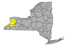
Draining an area encompassing more than 265,000 square miles in the north central United States and south-central Canada, including Tonawanda Creek, Cattaraugus Creek, Buffalo River; Attica Reservoir and Lime Lake. Flows through this watershed drain parts of Niagara, Wyoming and all of Erie County
Tonawanda Creek drains an area of 349 sq miles in Niagara, Genesee and Wyoming Counties
- Normal flow at Attica is around 250 cfs and 4 ft deep (flood stage 8ft);
- Normal flow at Batavia in Genesee County is around 800 cfs and 4 ft deep (flood stage 9ft);
- Normal flow at Rapids is around 1000 cfs and 4 ft deep (flood stage 12ft)
Ellicott Creek drains an area of 82 sq miles in Niagara County. The normal flow at Williamsville is around 200 cfs and 2.5 ft deep (flood stage 8ft).
Cayuga Creek drains an area of 96 sq miles in Erie County. The normal flow at Lancaster is around 200 cfs and 4 ft deep (flood stage 8ft)
Cazenovia Creek drains an area of 135 sq miles in Erie County. The normal flow at Ebenezer is 350 cfs and 3 ft deep. (flood stage 10 ft)
Buffalo Creek drains an area of 142 sq miles in Erie County. The normal flow measured at Gardenville is 400 cfs and 2 ft deep (flood stage 7ft)
Cattaraugus Creek drains an area of 436 sq miles in Erie County. The normal flow at Gowanda is around 1500 cfs and 3 ft deep, (flood stage 10ft) temp and conductance are taken here
Eighteenmile Creek drains an area of 36.6 sq miles in Erie County. The flow
- Normal flow at Hamburg is 100 cfs and 3 ft deep
- S Branch flow at Bley Rd at Eden Valley is unrated, we have seen this around 80 cfs and 3.5 ft deep
Big Sister Creek drains an area of 48.4 sq miles in Erie County. The flow at Evans Center is unrated, can be around 100 cfs and 3.5 ft deep.
Canadaway Creek drains an area of 32.9 sq miles in Cattaraugus County. The flow at Fredonia is unrated, a common measurement is around 65 cfs and 2.8 ft deep
Chautauqua Creek drains an area of 35 sq miles in Chautauqua County. The flow below Westfield is unrated, it can be around the 80 cfs and 1 ft deep
Flows (5 low)as of June 12, 2023
Buffalo Creek is flowing low at Gardenville - down overnight - running .57 ft deep and 24.3 cubic feet per second
Cazenovia Creek is flowing much below normal at Ebeneezer - running 2.32 ft deep and 25.6 cubic feet per second
Cayuga Creek is flowing much below normal near Lancaster - running 2.8 ft deep and 8.74 cubic feet per second
Tonawanda Creek is flowing
- low at Attica - running 3.33 ft deep and 12.8 cubic feet per second
- low at Batavia - down overnight - running 1.61 ft deep and 26.7 cubic feet per second
- low at Rapids - running 1.25 ft deep and 43.8 cubic feet per second
Cattaraugus Creek is flowing much below normal at Gowanda - running 1.39 ft deep and 179 cubic feet per second
Impaired Water Bodies (49)
49 water bodies appear on the 2022 Draft 303(d) list for Niagara River and Lake Erie Watershed, up from 11 on the last list. Of the 49 total, 24 are affected by a proposed delisting in 2022, in whole or in part. For more details, check out the posted list under the NW tab.
Drinking Water Advisories (1)
June 7- Fredonia (Chautauqua) Boil Water Advisory issued by the Chautauqua County Health Department for all Village of Fredonia water customers, including those that live outside of the Village in the Town of Pomfret.
HABs (2)
Tonawanda Creek - large localized bloom reported at Amherst Veterans Canal Park in Erie County- reported by the public May 26
Lake Kirsty - large localized bloom confirmed in the Tifft Nature Preserve in Erie County - reported by the public June 6
Spills (8)
- June 5 - unknown amount of home heating oil reported spilled at a private residence on State Route 372 in Cambridge – Washington
- June 5 - unknown amount of unknown chemical reported spilled at a private residence on Birchwood Square in West Seneca – Erie
- June 6 - unknown amount of sulfuric acid reported spilled due to equipment failure on Sawyer Ave in Tonawanda – Erie
- June 6 - unknown amount of hydraulic oil reported spilled due to equipment failure at a national grid on Kingston Ave in Buffalo - Erie
- June 8 - 40 gallons of brayco-90 reported spilled due to equipment failure at a manufacturing building on Jamison Rd in Elma – Erie
- June 8 - unknown amount of unknown petroleum reported spilled at a National Fuel Utility Center on Barbados Dr in Cheektowaga – Erie
- June 9 - unknown amount of diesel reported spilled from a Greyhound Bus Station on Ellicott St in Buffalo - Erie
- June 9 - 350 gallons of refrigerant reported leaking due to equipment failure at Linde Facility on Royal Ave in Niagara – Niagara
Genesee River Watershed
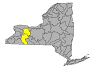
Genesee River originates in north central Pennsylvania and flows north through New York, following from the south state line up to Lake Ontario at Rochester. The watershed includes the following tributary flows, lakes and reservoirs: Conesus Lake, Silver Lake, Mount Morris Reservoir, Hemlock Lake, Honeoye Lake; Cassadaga Creek, Honeoye Creek, Oatka Creek, Black Creek
taking runoff from parts of Monroe, Livingston, and Allegany Counties
Genesee River drains an area of 2474 sq miles in Monroe, Livingston and Allegany Counties
- Normal flow at Wellsville in Allegany County is around 350 cfs and 5 ft deep (flood stage 11 ft)
- at Portageville in Wyoming County normal flow is around 1000 cfs and 9.95 ft deep (flood stage 19ft)
- near Mount Morris in Livingston County normal flow is around 1750 cfs and 5 ft deep
- at Avon normal flow is 2200 cfs and 21 ft deep (flood stage 33 ft)
- flow is unrated at Ballantyne Bridge near Mortimer, it often is around 3000 cfs and 12 ft deep
- at Ford St. Bridge in Rochester, Monroe County, normal flow will be around 4000 cfs and 12 ft deep, temp and conductance are observed and recorded here
Allen Creek drains an area of 28.9 sq miles in Monroe County. The normal flow near Rochester is around 30 cfs and 2.5 ft deep with temperature monitor
Honeoye Creek drains an area of 196 sq miles of Monroe County. The normal flow at Honeoye Falls in Monroe County is around 120 cfs and 3 ft deep (flood stage 6.5 ft)
Conesus Creek drains an area of 72 sq miles in Livingston County. Normal flow near Lakeville in Livingston County is 200 cfs and 2.5 ft deep.
Canaseraga Creek drains an area of 88.9 sq miles of Livingston County
- Normal flow above Dansville is around 80 cfs and under a foot deep
- at Shakers Crossing in Livingston County normal flow is around 280 cfs and 4 ft deep
Keshequa Creek drains an area of 68.3 sq miles in Livingston County, flowing north to join Genesee River. The flow at Sonyea is unrated, about 50 cfs and under a foot deep
Oatka Creek drains an area of 200 sq miles in Monroe County. The flow
- at Warsaw normal flow is around 60 cfs and 3 ft deep
- at Garbutt normal flow is around 300 cfs and 3 ft deep (flood stage 6ft)
Black Creek drains an area of 130 sq miles in Monroe County. The normal flow at Churchville is around 180 cfs and 2.5 ft deep, (flood stage 6ft)
Flows (3 low)as of June 12, 2023
Genesee River is flowing
- low near Wellsville - running 4.35 ft deep and 41.2 cubic feet per second
- much below normal at Portageville - running 8.52 ft deep and 201 cubic feet per second
- much below normal at Mount Morris - down overnight - running 2.47 ft deep and 244 cubic feet per second
- much below normal at Avon - running 14.27 ft deep and 317 cubic feet per second
- below normal at Ford St Bridge Rochester - down overnight - running 12.84 ft deep and 587 cubic feet per second
Oatka Creek is flowing much below normal at Warsaw - down overnight - running 3.17 ft deep and 9.17 cubic feet per second
Canaseraga Creek is flowing
- low above Dansville - running .27 ft deep and 16.2 cubic feet per second
- much below normal at Shakers Crossing - running 3.64 ft deep and 65.3 cubic feet per second
Impaired Water Bodies (23)
23 water bodies appear on the 2022 Draft 303(d) list for Genesee River Watershed, up from 11 in the last list. Of the 23 total, 6 are affected by a proposed delisting in 2022, in whole or in part. For more details, check out the posted list under the NW tab.
Drinking Water Advisories (0)
HABs (0)
Spills (4)
- June 6 -unknown amount of auto waste fluids reported spilled from a motor vehicle accident on NY Route 256 in Dansville – Livingston
- June 7 - unknown amount of unknown petroleum reported spilled from New York Department of Transportation on South Union St in Spencerport – Monroe
- June 8 - 50 gallons of diesel reported spilled due to equipment failure from Tandoi Asphalt and Sealcoating on Industrial St in Rochester – Monroe
- June 11 - unknown amounts of motor oil reported spilled due to equipment failure from a vessel at the Silver Lake Boat Launch on W Lake Rd in Castile - Wyoming - Silver Lake affected *
Oswego River - Finger Lakes Watershed
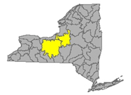
The Oswego River originates in the Adirondacks, with the combined flows of the Seneca River and many tributaries, drains a large area of north New York to Lake Ontario. The water bodies found in this drainage basin include the Finger Lakes: Otisco, Skaneateles, Owasco, Cayuga, Oneida, Seneca, Keuka, Canandaigua and Canadice Lakes; Oneida River, Clyde River, Cayuga Lake Tributaries and Seneca Lake Tributaries taking the runoff from parts of Oswego, Madison, Cayuga, Tompkins, Seneca, Onondaga, Yates and Ontario Counties.
Oswego River drains an area of 5100 sq miles of Oswego, Madison, Cayuga, Tompkins, Seneca, Onondaga, Yates and Ontario counties. The flow
- near Phoenix is not rated, can be around 10000 cfs and 3.5 ft deep
- at Lock 7 in Oswego County normal flow is around 18000 and 8.5 ft deep; temp and conductance are measured here
Seneca River drains an area of 3130 sq miles of Onandaga County
- near Seneca Falls flow is unrated, often around 1000 cfs and 3.8 ft deep
- at Free Bridge Corners flow is unrated, gets to running 3500 cfs and 9 ft deep
- near Port Byron flow is unrated, usually under 6000 cfs and 6 ft deep
- near Baldwinsville in Onondaga County normal flow is 6000 cfs and 3.5 ft deep
Ganaragua Creek drains an area of 115 sq miles in Wayne County before joining the Oswego River. The flow at Macedon is unrated, 100 cfs and 2.5 ft deep is common
Canandaigua Outlet drains 195 sq miles of Ontario County. The normal flow at Chapin in Ontario County is 200 cfs and 3 ft deep (flood stage 7ft)
Owasco Inlet drains an area of 106 sq miles in Cayuga County. The flow
- below Aurora St at Moravia is unrated, often around 220 cfs and 3 ft deep
- at Owasco Outlet at Genesee St Auburn is unrated, we see this water flowing around 700 cfs and 3.8 ft deep (flood stage 8 ft)
Skaneateles Creek drains an area of 85.9 sq miles in Onandaga County. The flow at Skaneateles Junction is unrated, around 35 cfs and 2 ft deep
Flint Creek drains an area of 102 sq miles of Ontario County. Normal flow at Phelps in Ontario County is around 100 cfs and 2 ft deep.
Keuka Lake drains an area of 207 sq miles in Yates County. At the outlet near Dresden in Yates County, the normal flow 350 cfs and 3.5 ft deep
Fish Creek drains an area of 403 sq miles in Oneida County. The flow at Becks Grove is unrated, can be seen around 1000 cfs and 6.5 ft deep.
East Branch Fish Creek drains 188 sq miles in Oneida County. Normal flow at Taberg is 480 cfs and 5.2 ft deep.
Oneida Creek drains an area of 113 sq miles in Oneida County. Normal flow at Oneida is around 250 cfs and 2.5 ft deep (flood 11ft)
Oneida River drains an area of 1349 sq miles of Oneida County. The flow near Euclid is unrated, around 4500 cfs and 3.5 ft deep
Scriba Creek drains an area of 38.4 sq miles in Oswego County. The flow at Constantia is unrated, around 80 cfs and 2.5 ft deep.
Chittenango Creek drains an area of 66.3 miles of Madison County, flowing into Oneida Lake, into Oneida River and joining the Oswego River. The flow near Chittenango is unrated, around 160 cfs and 2 ft deep. (flood stage 6ft)
Onondaga Creek drains an area of 110 sq miles of Onandaga County
- at Dorwin Ave in Syracuse normal flow is around 175 cfs and 2.3 ft deep, (flood stage 5 ft)
- normal flow at Spencer St in Syracuse is around 200 cfs and 3.3 ft deep.
Salmon Creek drains an area of 87.7 sq miles in Tompkins County. The flow at Ludlowville is unrated, often measuring around 160 cfs and 1.3 ft deep
Sixmile Creek drains an area of 39 sq miles in Tompkins County
- at Brooktondale flow is unrated, measures around 50 cfs and under a foot deep
- at Bethel Grove flow is unrated, around 55 cfs and 1.4 ft deep.
Fall Creek drains an area of 126 sq miles of Tompkins County. Normal flow near Ithaca is around 230 cfs and 1.5 ft deep (flood stage 6ft).
Flows (3 low)as of June 12, 2023
East Branch Fish Creek is flowing much below normal at Taberg- running 3.82 ft deep and 69.5 cubic feet per second
Seneca River is flowing much below normal near Baldwinsville - up overnight - running 2.73 ft deep and 504 cubic feet per second
Fall Creek is flowing much below normal at Ithaca - running .64 ft deep and 33 cubic feet per second
Impaired Water Bodies (40)
40 water bodies appear on the 2022 Draft 303(d) list for Oswego River Watershed, up from 7 in the last list. Of the 40 total, 11 are affected by a proposed delisting in 2022, in whole or in part. For more details, check out the posted list under the NW tab.
Drinking Water Advisories (0)
HABs (0)
Spills (8)
- June 5 - unknown amount of unknown material reported spilled on a beach on Apulia Rd in Jamesville – Onondaga
- June 6 - unknown amount of paint reported spilled at a Municipal office on Canal St Exit in Syracuse – Onondaga
- June 6 - unknown amount of waste oil reported spilled from Sessler Waste oil on Route 96 in Waterloo – Seneca
- June 7 - unknown amount of unknown petroleum reported spilled across from Irving Ave in Syracuse - Onondaga
- June 8 - unknown amount of unknown material reported spilled deliberately on the concrete reported spilled on Prospect St in Auburn - Cayuga
- June 11 - 150 gallons of sodium hydroxide reported spilled due to equipment failure at a private residence on County Route 1A in Scriba – Oswego
- June 11 - unknown amounts of gasoline reported spilled due to equipment failure from a vessel on Skaneateles Lake on the west shore line in Skaneateles - Onondaga - Skaneateles Lake affected
- June 11 - 2 gallons of diesel reported spilled at Oswego Canal on Canal View Dr in Oswego - Oswego - Oswego River affected *
Report Key
Flows
WTNY describes the stream flows in each of 17 watersheds, including direction/path of flow, listing monitoring stations in order from headwaters to outlet, indicating the normal flow volume in cubic feet per second (CFS), the gage height (flow depth) during normal conditions and the flood stages, or the gage height at which flooding will occur. Locate your “home body” (the river or stream nearest you) to see where the flow originates, how high the flow must be for minor flooding to occur. Log in to USGS Waterwatch current streamflow for real time measurements at the monitoring station nearest you and sign up there for high flow alerts.
Flow volume can change rapidly during snowmelt and rain events, check your local upstream station flow levels at the USGS WaterWatch Current Streamflow site, or sign up for high flow alerts to your mobile device. Streamflow data is subject to review as sensors at the monitoring stations do malfunction from time to time. See USGS Provisional Data Statement at the end of this report for more information.
EPA Impaired Water Bodies 303d List
The EPA requires all states update a draft list of impaired water bodies (the 303d list) every two years; providing a period for public comments, presenting the draft list to the EPA. The final 303d list is published as approved by the EPA, roughly every two years.
Impaired water bodies are defined as those with contaminants measured above threshold levels, as set by the EPA Clean Water Act, or where the desired use is impaired. The latest Draft List for New York State, covering 2020-2022 has closed for public comments, being submitted to EPA for review. (See the 2020-2022 Draft Impaired Water Bodies 303(d) List, organized by watershed area, here on this site.) The 2020-2022 Draft list includes NYS lakes, creeks, rivers and reservoirs that New York Department of Environmental Conservation has recommended for de-listing, along with water bodies requiring Total Maximum Daily Load (TMDL) plans. The TMDL plan is a type of Clean Water Plans, established by a collaboration of municipal, industrial and environmental groups in an overlay zoning district.
Hazardous Algae Blooms (HABs) Beach Alerts – monitoring is complete for the season, will resume in spring 2023
Hazardous algae blooms are reported here as they are confirmed across the state, as found on the NYS Department of Environmental Conservation NYHABs notification site.
- active blooms are reports current within two weeks, observed reported and confirmed. These are listed by water body with date and time of the report, placed in the applicable watershed, with location information (accuracy of our location description is limited by the accuracy of the location tag in the report to NY DEC).
Contact parks management for the current information on local conditions before heading out and consider using an on-site rapid test for microcystin toxin.
Drinking Water Advisories
Boil Water and Do not Consume advisories issued by drinking water facilities for various reasons, short term disruptions due to water main breaks, repairs, loss of pressure are posted here by watershed area. NYS and EPA Region 2 Drinking water facility notices are posted here.
Spills
NYS Spill Hotline: 1-800-457-7362
National Response Center: 1-800-424-8802
Reporting from the latest records uploaded to the NYS Hazardous Spill Incidents database by County each week.
- Spills of petroleum products of 40 gallons or more are listed weekly in the watershed in which they occur, citing location of the spill, the contaminant spilled (if known), the quantity (if known) and the resource affected (if known) surface water, groundwater, sewer, etc, and any amount recovered at the site.
Spills over 100 gal, very toxic chemical spills and spills that impact state waters are flagged and followed up with the spiller, the state and/or EPA authorities for more information, these are marked with asterisk.*
See NY Spills Tracker for more information on these spills as it becomes available.
Note: DEC receives upward of sixteen thousand spill reports each year; each report is investigated by qualified personnel. Report files are closed when it is determined the spill is contained and under the control of the spiller or state authorities and a clean up plan is in place or completed.
Sources
WaterToday New York aggregates information and data from New York State Department of Environmental Conservation, Department of Health, Region 2- EPA, USGS, NWS, NOAA by watershed area. The accuracy of the information contained in our reports is dependent on these sources. Provisional data statements apply, confirm data with local authorities before taking action.
|
All rights reserved 2026 - WTNY - This material may not be reproduced in whole or in part and may not be distributed,
publicly performed, proxy cached or otherwise used, except with express permission.
|
|
|
