  
Watershed Report
South/West NYS With the Flow
Report for the Week of June 5 to June 11, 2023
Low flows continue
Find your location in the southwest drainage basin of New York State. Impacts to water in this drainage basin move south of border, Allegheny River watershed tilts runoff toward the Ohio and Mississippi Rivers, carrying mobile contaminants down to the Gulf of Mexico through Louisiana. The Chemung, Susquehanna and Ramapo Rivers drain portions of southern state across the southern border and out to the Atlantic Ocean via Chesapeake Bay.
|
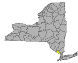
South – West NY Drainage Area
|
Low Flows
|
Impaired
Water
Bodies 303d list
|
HABs
|
Boil Water Advisories
|
Hazardous
Spills
|
|
Allegheny River
|
2
|
14
|
1
|
0
|
6
|
|
Chemung River
|
4
|
9
|
1
|
0
|
2
|
|
Susquehanna River
|
5
|
18
|
0
|
0
|
3
|
|
Ramapo River
|
0
|
14
|
0
|
0
|
1
|
|
Totals
|
11
|
55
|
2
|
0
|
12
|
Table updated June 12, 2023
Allegheny River Watershed
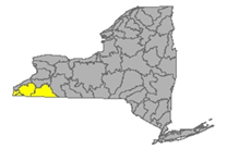 The Allegheny River originates in Pennsylvania, curving north to take a short loop through southwest New York and back down into PA. Tributaries to the Allegheny system include Chadakoin River, Conewango Creek, Cassadaga Creek, Olean Creek, Great Valley Creek, French Creek. Important water bodies include the Allegheny Reservoir and popular recreational destination, Chautauqua Lake.
Flows taking in parts of Chautauqua and Cattaraugus County
Chadakoin River drains an area of 194 sq miles of Chautauqua County. Normal flow at Falconer is around 700 cfs and 2.5 ft deep (flood stage 4ft)
Allegheny River drains an area of 1608 sq miles of Cattaraugus County. The flow
- at Olean is unrated, around 2000 cfs and 3.7 ft deep (flood stage 12 ft)
- at Salamanca normal flow is around 2800 cfs and 4.4 ft deep, (flood stage 12 ft) temperature is recorded here
Dodge Creek drains an area of 47.7 sq miles in Cattaraugus County. The flow at Portville is unrated, 3.8 ft deep
Low Flows (2)
Allegheny River is flowing much below normal at Salamanca - slowing to 2.76 ft deep and 365 cubic feet per second
Chadokoin River is flowing much below normal at Falconer - slowing to unreadable ft deep and 45.6 cubic feet per second
Impaired Water Bodies (14)
14 water bodies appear on the 2022 Draft 303(d) list for Allegheny River Watershed, up from 8 in the last list. Of the 14 total, 2 are affected by a proposed delisting in 2022, in whole or in part.
For more details, check out the posted list under the SW tab.
Drinking Water Advisories (0)
HABs (1)
May 31 Chautaqua Lake - small localized bloom confirmed in Chautauqua County near shore off Watson Rd - reported by the Chautauqua Lake Association
Spills (6)
- June 5 - unknown amount of liquid material reported spilled in a residential area on Hahn Rd in Fredonia – Chautauqua
- June 6 - unknown amount of fire run off reported spilled at a commercial location on Union St in Allegany – Cattaraugus
- June 9 - unknown amount of home heating oil reported spilled at Olean Intermediate Middle School on West Sullivan St in Olean – Cattaraugus
- June 9 - unknown amount of unknown petroleum reported spilled on Bixby Hill Rd in Freedom – Cattaraugus
- June 9 - 200 crude oil reported spilled from vandalism at a commercial location on Bixby Hill Rd in Arcade – Cattaraugus
- June 10 - unknown amount of unknown material reported deliberately dumped into a residential pond on Mt Pleasant Rd in Sherman - Chautauqua - impact to Chautauqua Lake *
Chemung River Watershed
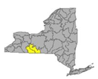
The Chemung River drains a portion of the southern state picking up runoff from the southwest and flowing east, joins the Susquehanna River and exits the state and out to the Atlantic Ocean via Chesapeake Bay.
Includes tributaries Cohocton River, Tioga River, Canisteo River and lakes including Lamoka Lake/Mill Pond, Waneta Lake, Almond Lake taking surface runoff from parts of Steuben and Chemung Counties.
Chemung River drains an area of 2506 sq miles in Steuben and Chemung Counties. The flow
- at Corning normal flow is around 1700 cfs and 16 ft deep (flood stage is 29ft)
- at Elmira in Chemung County, flow is unrated around 2000 cfs and 2 ft deep (flood stage 12 ft)
- at Chemung normal flow is 2500 cfs and 5 ft deep. (flood stage 16 ft)
Canisteo River drains an area of 40 sq miles of Steuben County. The flow
- at Arkport normal flow is around 30 cfs and 1 ft deep
;
- below Canacadea Creek at Hornell in Steuben County normal flow is around 100 cfs and 1.3 ft deep (flood stage 9ft)
- at West Cameron in Steuben County flow is normal, 300 cfs and 4.5 ft deep (flood stage 17ft).
Canacadea Creek drains an area of 57.9 sq miles in Steuben County. Normal flow is around 110 cfs and 1.2 ft deep
Cohocton River drains an area of 370 sq miles of Steuben County. The flow
- near Avoca flow is unrated, around 250 cfs and 3 ft deep (flood stage 9ft)
- at Bath flow is 3.7 ft deep (flood stage 11ft)
- near Campbell in Steuben County normal flow is around 600 cfs and 3.5 ft deep (flood stage 10ft).
Tuscarora Creek drains an area of 102 sq miles sq miles in Steuben County before joining the Tioga River, flowing north to the Chemung system. The flow above South Addison is unrated, around 80 cfs and under a foot deep (flood stage 9 ft)
Tioga River drains an area of 1377 sq miles in Steuben County. The flow
- at Tioga Junction, PA normal flow is 90 cfs and 5.5 ft deep, temp and conductance is measured here
- at Lindley, NY, normal flow is around 900 cfs and 5 ft deep
- near Erwins normal flow is around 1500 cfs and 2.7 ft deep (flood stage 18ft)
Low Flows (4)
Canisteo River is flowing
- low at Arkport - down overnight -running .67 ft deep and 1.53 cubic feet per second
- much below normal below Canacadea Creek at Hornell - down overnight - running .6 ft deep and 26 cubic feet per second
- much below normal at West Cameron - down overnight - running 3.56 ft deep and 45.3 cubic feet per second
Canacadea Creek is flowing much below normal near Hornell - running .89 ft deep and 9.13 cubic feet per second
Tioga River is flowing
- much below normal at Lindley - down overnight- running 2.97 ft deep and 69.9 cubic feet per second
- low near Erwins - down again overnight - running .57 ft deep and 129 cubic feet per second
Chemung River is flowing
much below normal at Corning - running 14.65 ft deep and 279 cubic feet per second
much below normal at Chemung - running 3.65 ft deep and 297 cubic feet per second
Impaired Water Bodies (9)
9 water bodies appear on the 2022 Draft 303(d) list for Chemung River Watershed, up from one in the previous list. Of the 9 total, 2 are affected by a proposed delisting in 2022, in whole or in part.
For more details, check out the posted list under the SW tab.
Drinking Water Advisories (0)
HABs (1)
June 8 - Lamoka Lake - small localized bloom confirmed on the east shore off Lamoka Lake Rd in Schuyler County - reported by the public
Spills (2)
- June 7 - unknown amount of gasoline reported spilled from a traffic accident on Mitchellville Hill Rd in Urbana – Steuben
- June 9 - unknown amount of motor oil reported spilled deliberately on Cleveland Hill Rd in Caton – Steuben
Susquehanna River Watershed
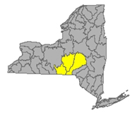
The Susquehanna River drains 27,500 square miles of New York, Pennsylvania and Maryland before emptying into the Atlantic Ocean at Chesapeake Bay. The flow begins in south New York State and flows in a westerly direction close to the south state line before departing into PA. Includes tributaries: Chenango River, Tioughnioga River, Unadilla River, Owego Creek; includes Otsego Lake, Canadarago Lake, Whitney Point Lake/Reservoir taking runoff from parts of Otsego, Broome, Chenango and Cortland Counties
Susquehanna River drains an area of 4773 sq miles of Otsego and Broome Counties, flows from its headwaters at Otsego Lake in a south-westerly direction, crossing the border into Pennsylvania near Waverly NY. The flow
- Normal flow at Unadilla is around 2200 cfs and 4.8 (flood stage 11 ft) ft deep
- at Bainbridge flow is unrated, we have seen it around 3500 cfs and 4.5 ft deep (flood stage 15 ft)
- at Windsor, flow is unrated, around 3500 cfs and 6.29 ft deep (flood stage 17ft)
- at Conklin, normal flow is around 4900 cfs and 6 ft deep (flood stage 12 ft)
- at Binghamton, the flow is not rated, 3.7 ft deep, (flood stage 14 ft)
- at Vestal in Broome County normal flow is 6500 cfs and 6.5 ft deep (flood stage 18 ft)
- at Owego flow is unrated, 7000 cfs and 16 ft deep (flood stage 30 ft)
- at Waverly, normal flow is 8000 cfs and 4 ft deep (flood stage 13 ft)
Owego Creek drains an area of 185 sq miles in Tioga County. Normal flow near Owego is unrated, often around 300 cfs and under 2 ft deep (flood stage 9 ft)
Chenango River drains an area of 1483 sq miles in Broome and Chenango Counties. The flow
- Normal flow at Sherburne is around 400 cfs and 3 ft deep (flood stage 8.5 ft )
- at Oxford in Chenango is unrated, we see this around 650 cfs and 9.3 ft deep
- normal flow at Greene in Chenango County flow is around 1000 and 4 ft deep; (flood stage 13 ft)
- normal flow at Chenango Forks in Broome County is around 2500 cfs and 4.2 ft deep (flood stage 10ft)
Tioughnioga River drains an area of 292 sq miles in Cortland County. The flow
- normal flow at Cortland is around 700 cfs and 4 ft deep
- at Lisle, unrated, measuring around 3.2 ft deep (flood stage 9ft)
- at Itaska the flow is not rated, flows measure around 3 to 3.5 ft deep (flood stage 7 ft)
Otselic River drains an area of 147 sq miles in Cortland County. Normal flow at Cincinnatus is around 250 cfs and 2 ft deep (flood stage 9 ft)
Unadilla River drains an area of 520 sq miles of Chenango County. Normal flow at Rockdale is around 1000 cfs and 5 ft deep (flood stage 11 ft)
Ouleout Creek drains an area of 103 sq miles in Delaware County. Normal flow at East Sydney is 250 cfs and 2 ft deep (flood stage 4.5 ft)
Low Flows (5)
Susquehanna River is flowing
- low at Unadilla - down considerably overnight to 2.67 ft deep and 320 cubic feet per second
- low at Conklin - down overnight to 2.64 ft deep and 743 cubic feet per second
- low at Vestal - up slightly overnight - 2.57 ft deep and 1100 cubic feet per second
- much below normal at Waverly - running 1.38 ft deep and 1400 cubic feet per second
Unadilla River is flowing much below normal at Rockdale - running 4.34 ft deep and 177 cubic feet per second
Chenango River is flowing
- below normal at Sherburne - up overnight - running 1.88 ft deep and 93.6 cubic feet per second
- much below normal at Chenango Forks - running 2.79 ft deep and 447 cubic feet per second
Tioughnioga River is flowing much below normal at Cortland - running 3.05 ft deep and 117 cubic feet per second
Ouleout Creek is flowing low at East Sydney - running 1.07 ft deep and 15.6 cubic feet per second
Impaired Water Bodies (18)
18 water bodies appear on the 2022 Draft 303(d) list for Susquehanna River Watershed, up from three in the last listing. For more details, check out the posted list under the SW tab.
Drinking Water Advisories (0)
HABs (0)
Spills (3)
June 7 - unknown amount of motor oil reported spilled at a private residence on Camden St in Johnson City – Broome
June 9 - unknown amount of motor oil reported spilled in a residential area on County Route 26 in Fly Creek – Otsego
June 11 - unknown amounts of gasoline reported spilled from a traffic accident on State Route 96 and 38 in Oswego – Tioga
Ramapo River Watershed
 The northern headwaters of the Passaic basin lie within a small portion of southeastern New York State, including the Ramapo and Hackensack Rivers drainage areas, flowing south through New Jersey with outlet into the Atlantic at Chesapeake Bay. Including Ramapo River, Hackensack River, Greenwood Lake, DeForest Lake taking runoff from parts of Rockland and Orange Counties
Mahwah River drains an area of 12 sq miles in Rockland. Normal flow near Suffern is around 50 cfs and 2.5 feet deep (flood stage 5ft)
Ramapo River drains an area of 93 sq miles in Rockland County. The flow
- at Ramapo normal flow is around 300 cfs and 3.5 ft deep (flood stage is 10 ft)
- normal flow near Mahwah NJ is under 500 cfs and 4 ft deep (flood stage 8ft)
- at Suffern, normal flow is under 500 cfs and 4 ft deep (flood stage is 15.2ft)
Hackensack River drains an area of 30.7 sq miles in Rockland County. Normal flow at West Nyack is under 100 cfs and 3.5 ft deep.
Low Flows (0)
Impaired Water Bodies (14)
14 Water bodies appear on the Draft 303(d) list for Ramapo River watershed in 2022, with 5 proposed for delisting, in whole or in part.
For more details, check out the posted list under the Ramapo tab.
HABs (0)
Spills (1)
- June 9 - unknown amount of home heating oil reported spilled due to equipment failure at a private residence on County Club Lane in Pomona – Rockland
Report Key
Flows
WTNY describes the stream flows in each of 17 watersheds, including direction/path of flow, listing monitoring stations in order from headwaters to outlet, indicating the normal flow volume in cubic feet per second (CFS), the gage height (flow depth) during normal conditions and the flood stages, or the gage height at which flooding will occur. Locate your “home body” (the river or stream nearest you) to see where the flow originates, how high the flow must be for minor flooding to occur. Log in to USGS Waterwatch current streamflow for real time measurements at the monitoring station nearest you and sign up there for high flow alerts.
Flow volume can change rapidly during snowmelt and rain events, check your local upstream station flow levels at the USGS WaterWatch Current Streamflow site, or sign up for high flow alerts to your mobile device. Streamflow data is subject to review as sensors at the monitoring stations do malfunction from time to time. See USGS Provisional Data Statement at the end of this report for more information.
EPA Impaired Water Bodies 303d List
The EPA requires all states update a draft list of impaired water bodies (the 303d list) every two years; providing a period for public comments, presenting the draft list to the EPA. The final 303d list is published as approved by the EPA, roughly every two years.
Impaired water bodies are defined as those with contaminants measured above threshold levels, as set by the EPA Clean Water Act, or where the desired use is impaired. The latest Draft List for New York State, covering 2020-2022 has closed for public comments, being submitted to EPA for review. (See the 2020-2022 Draft Impaired Water Bodies 303(d) List, organized by watershed area, here on this site.) The 2020-2022 Draft list includes NYS lakes, creeks, rivers and reservoirs that New York Department of Environmental Conservation has recommended for de-listing, along with water bodies requiring Total Maximum Daily Load (TMDL) plans. The TMDL plan is a type of Clean Water Plans, established by a collaboration of municipal, industrial and environmental groups in an overlay zoning district.
Hazardous Algae Blooms (HABs) Beach Alerts – monitoring is complete for the season, will resume in spring 2023
Hazardous algae blooms are reported here as they are confirmed across the state, as found on the NYS Department of Environmental Conservation NYHABs notification site.
- active blooms are reports current within two weeks, observed reported and confirmed. These are listed by water body with date and time of the report, placed in the applicable watershed, with location information (accuracy of our location description is limited by the accuracy of the location tag in the report to NY DEC).
Contact parks management for the current information on local conditions before heading out and consider using an on-site rapid test for microcystin toxin.
Drinking Water Advisories
Boil Water and Do not Consume advisories issued by drinking water facilities for various reasons, short term disruptions due to water main breaks, repairs, loss of pressure are posted here by watershed area. NYS and EPA Region 2 Drinking water facility notices are posted here.
Spills
NYS Spill Hotline: 1-800-457-7362
National Response Center: 1-800-424-8802
Reporting from the latest records uploaded to the NYS Hazardous Spill Incidents database by County each week.
- Spills of petroleum products of 40 gallons or more are listed weekly in the watershed in which they occur, citing location of the spill, the contaminant spilled (if known), the quantity (if known) and the resource affected (if known) surface water, groundwater, sewer, etc, and any amount recovered at the site.
Spills over 100 gal, very toxic chemical spills and spills that impact state waters are flagged and followed up with the spiller, the state and/or EPA authorities for more information, these are marked with asterisk.*
See NY Spills Tracker for more information on these spills as it becomes available.
Note: DEC receives upward of sixteen thousand spill reports each year; each report is investigated by qualified personnel. Report files are closed when it is determined the spill is contained and under the control of the spiller or state authorities and a clean up plan is in place or completed.
Sources
WaterToday New York aggregates information and data from New York State Department of Environmental Conservation, Department of Health, Region 2- EPA, USGS, NWS, NOAA by watershed area. The accuracy of the information contained in our reports is dependent on these sources. Provisional data statements apply, confirm data with local authorities before taking action.
|
All rights reserved 2026 - WTNY - This material may not be reproduced in whole or in part and may not be distributed,
publicly performed, proxy cached or otherwise used, except with express permission.
|
|
|
