  
2022/7/11
Watershed Report
brought to you in part by

With the Flow – New York State Watershed Report for the Week of July 18 to July 24, 2022
By Gillian Ward
|
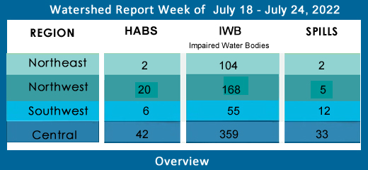
OVERVIEW
 | LAST WEEK

|
SEE BELOW FOR DETAILS
|
Table of Contents - Click on location links to go to information
With the Flow – NY Watersheds Report for the Week July 18-24, 2022
Contents
Introduction. 12
To Flows. 12
To EPA Impaired Water Bodies 303d List 13
To Hazardous Algae Blooms (HABs) Beach Alerts 13
To Spills. 14
Sources: 14
Central NY Watersheds 14
Upper Hudson River Watershed. 14
Flows parts of Essex, Hamilton, Saratoga, Washington, Rensselaer and Warren Counties 15
Impaired Water Bodies (26) 17
Hazardous Algae Bloom (HABs) Beach Alerts (0) 17
Spills (1 new) 17
Mohawk River Watershed. 18
Flows draining parts of Schenectady, Oneida, Herkimer, Montgomery, and Albany Counties 18
Impaired Water Bodies (28) 21
Hazardous Algae Blooms (HABs) Beach Alerts (2 active) 22
Bear Gulch Pond (2 active) 22
Spills (1 new) 22
Lower Hudson River Watershed –. 22
Flows catching parts of Albany, Rensselaer, Dutchess, Columbia, Ulster Counties 23
Impaired Water Bodies (80) 27
Hazardous Algae Bloom (HABs) Beach Alerts (10 active) 27
Nooteeming Lake (0 active) 27
Deer Lake (0 active) 27
Seven Hills Lake (2 active) 27
Putnam Lake (0 active) 28
Lake Carmel (0 active. 28
Lake Casse (0 active) 28
Roaring Brook Lake (1 active) 28
Lake Peekskill (2 active) 28
Lake Lincolndale (0 active) 28
Lake Mohegan (2 active) 28
Lake Tiorati (0 active) 29
Beaverdam Lake (2 active) 29
Lake Welch (1 active) 29
Rockland Lake (0 active) 29
Spills (4 new) 29
Delaware River Watershed. 31
Flows streaming over parts of Delaware, Ulster, Sullivan Counties. 32
Impaired Water Bodies (25) 35
Hazardous Algae Blooms (HABs) Beach Alerts (1 active) 35
Silver Lake (0 active) 35
Evens Lake (1 active) 35
Spills (1 new) 35
Housatonic River Watershed. 35
Flows: parts of Dutchess County. 36
Impaired Water Bodies (0) 36
Hazardous Algae Blooms – HABs (0 new) 36
Spills (2 new) 36
Atlantic Ocean/Long Island Sound Watershed. 36
Flows taking in run-off from parts of Bronx, Queens, Kings, Suffolk, Nassau and New York Counties 37
Impaired Water Bodies (200) 38
Hazardous Algae Blooms - HABs (19 active) 38
Unnamed Water (1 active) 38
Lake Waccabuc (0 active) 39
Sheldrake Lake (0 active) 39
Glenwood Lake (0 active) 39
Harlem Meer(1 active) 39
Turtle Pond (1 active) 39
The Lake in Central Park (2 active) 39
Prospect Park Lake (1 active) 39
Martlings Pond/Richmond Lake (1 active) 39
Clove Lake (1 active) 40
Silver Lake Reservoir (1 active) 40
Goose Pond in Captain Tilly Park (1 active) 40
Kissena Lake (1 active) 40
Roth Pond, on campus of Stony Brook University (0 active) 40
East Marion Lake (1 active) 40
Maratooka Lake (2 active) 40
Wainscott Pond of the Hamptons (1 active) 41
Agawam Lake, near the Hampton Bays (2 active) 41
Mill Pond (Watermill) (2 active) 41
Spills (23 new) 41
Northeast Watersheds 44
Lake Champlain Watershed. 44
Flows. 44
Impaired Water Bodies (29) 45
Hazardous Algae Bloom (HABs) Beach Alerts (1) 45
Lake Champlain (1 active) 45
Spills (1 new) 45
St. Lawrence River Watershed. 46
Flows: parts of St. Lawrence and Franklin Counties 46
Hazardous Algae Blooms (HABs) Beach Alerts (1 active) 48
Black Lake (1 active) 48
Spills (1 new) 48
Northwest Watersheds 49
Lake Ontario and Minor Tributaries 49
Flows considering most of Jefferson and Orleans Counties, parts of Monroe, Oswego, Wayne and Niagara Counties. 49
Impaired Water Bodies (56) 50
Hazardous Algae Blooms (HABs) Beach Alerts (2) 50
Braddock Bay, Lake Ontario (0 active) 50
Mud Bay, Lake Ontario (1 active) 50
Casey Park Pond (1 active) 50
Spills (0 new) 50
Black River Watershed. 51
Flows: Filters and drains most of Jefferson and Lewis Counties along with parts of Herkimer, Hamilton, and Oneida Counties. 51
Impaired Water Bodies (34) 52
Hazardous Algae Blooms (HABs) Beach Alerts (0) 52
Spills (0 new) 52
Niagara River/Lake Erie Watershed. 52
Flows: parts of Niagara, Wyoming and Erie Counties. 52
Impaired Water Bodies (49) 53
Hazardous Algae Bloom (HABs) Beach Alerts (1 active) 54
Ellicott Creek (1 active) 54
Spills (1 new) 54
Genesee River Watershed. 54
Flows parts of Monroe, Livingston, and Allegany Counties. 54
Impaired Water Bodies (23) 56
Hazardous Algae Blooms (HABs) Beach Alerts (7 active) 56
Conesus Lake (2 active) 56
Honeoye Lake (4 active) 56
Avon Marsh Dam Pond (0 active) 57
Silver Lake (1 active) 57
Spills (2 new) 57
Oswego River and Finger Lakes Watershed. 57
Flows draining parts of Oswego, Madison, Cayuga, Tompkins, Seneca, Onondaga, Yates and Ontario Counties. 58
Impaired Water Bodies. 60
Hazardous Algae Blooms (HABs) Beach Alerts (19 active) 60
Cross Lake (1 active) 60
Otisco Lake (6 active) 60
Cayuga Lake (8 active) 61
Jamesville Reservoir (1 Active) 61
Song Lake (1 active) 62
Fairport Reservoir (0 active) 62
Dryden Lake (1 active) 62
Casterline Pond (1 active) 62
Spills (5 new) 62
Southwest Watersheds 63
Allegheny River Watershed. 63
Flows taking in parts of Chautauqua and Cattaraugus County. 64
Impaired Water Bodies (14) 64
Hazardous Algae Blooms (HABs) Beach Alerts (17 active) 64
Chautauqua Lake (17 active) 64
Spills (1 new) 66
Chemung River Watershed. 66
Flows: washing over parts of Steuben and Chemung Counties 66
Impaired Water Bodies (9) 68
Hazardous Algae Blooms (HABs) Beach Alerts (1 active) 68
Tanglewood Lake (1 active) 68
Loon Lake (0 active) 68
Goodhue Lake (0 active) 68
Spills (0 new) 68
Susquehanna River Watershed. 68
Flows parts of Otsego, Broome, Chenango and Cortland Counties 69
Impaired Water Bodies (18) 70
Hazardous Algae Blooms (HABs) Beach Alerts (2 new) 70
Yogi and Boo Boo’s Campground Pond (1 active) 70
Earlville Lake (1 active) 70
Bradley Brook Reservoir (0 active) 70
Lake Moraine (0 active) 70
De Ruyter Reservoir (0 active) 70
Spills (2 new) 71
Ramapo River Watershed. 71
Flows. 71
Impaired Water Bodies (14) 72
Hazardous Algae Blooms (HABs) Beach Alerts (0) 72
Spills (0 new) 72
Introduction
Flows
WTNY describes the stream flows in each of NYS 17 watersheds, including direction/path of flow, listing 1200 monitoring stations in order from headwaters to outlet, including a flow rating (where available), flow volume in cubic feet per second (CFS), the depth of flow in feet and inches, the water temperature and specific conductance (where this information is available). WTNY logs a snapshot of the stream flows through the state’s rivers and tributaries once a month, as per USGS Waterwatch current streamflow monitoring stations.
- Rivers, and creeks flowing much above normal or high (in the top 10% of flow volume recorded for that system) are shown in boldface;
- flows that have breached action stage appear in red,
- flows in flood stage appear in boldface red type
.
- Ice-affected flows are shown in italics.
Flow volume can change rapidly during snowmelt and rain events. All readings are posted as they appear as of our monthly update.
During melting and rain events, check your local upstream station flow levels at the USGS WaterWatch Current Streamflow site or sign up for high flow alerts. Streamflow data is subject to review as sensors at the monitoring stations do malfunction from time to time. See USGS Provisional Data Statement at the end of this report for more information.
EPA Impaired Water Bodies 303d List
The EPA requires all states update a draft list of impaired water bodies (the 303d list) every two years; providing a period for public comments, presenting the draft list to the EPA. The final 303d list is published as approved by the EPA, roughly every two years.
Impaired water bodies are defined as those with contaminants measured above threshold levels, as set by the EPA Clean Water Act, or where the desired use is impaired. The latest Draft List for New York State, covering 2020-2022 has closed for public comments, being submitted to EPA for review. (See the 2020-2022 Draft Impaired Water Bodies 303(d) List, organized by watershed area, here on this site.) The 2020-2022 Draft list includes NYS lakes, creeks, rivers and reservoirs that New York Department of Environmental Conservation has recommended for de-listing, along with water bodies requiring Total Maximum Daily Load (TMDL) plans. The TMDL plan is a type of Clean Water Plans, established by a collaboration of municipal, industrial and environmental groups in an overlay zoning district.
Hazardous Algae Blooms (HABs) Beach Alerts
Hazardous algae blooms are reported here as they are confirmed across the state, as found on the NYS Department of Environmental Conservation NYHABs notification site.
- New confirmed HABs are listed with the diamond bullet ◆ by water body, date and time of the report, placed in the applicable watershed, with location information (accuracy of our location description is limited by the accuracy of the location tag in the report to NY DEC).
- HABs previously reported that remain active status are shown with a dash bullet.
Archived reports for the water body are mentioned in small print.
Contact parks management for the current information on local conditions before heading out and consider using an on-site rapid test for microcystin.
Spills
Reporting from the latest records uploaded to the NYS Hazardous Spill Incidents database by County each week.
- New spills over 40 gallons are listed weekly in the watershed in which they occur, with location of the spill, the contaminant spilled (if known), the quantity (if known) and the resource affected (if known) surface water, groundwater, sewer, etc, and any amounts recovered at the site.
- Spills reported previously and current within 30 days of the report
- Spills over 100 gals, very toxic chemical spills and spills that impact water, the highlighted spills are flagged and tracked with state and/or EPA authorities for more information. See the CrimeBox for details on violations and charges under the Clean Water Act.
The DEC receives over ten thousand spill reports each year; WTNY lists reported spills over 40 gallons, and all spills of unknown amounts, spills of very toxic substances, and all spills impacting state waters, regardless of the amount.
Sources:
WaterToday New York aggregates information and data from New York State Department of Environmental Conservation, Department of Health, Region 2- EPA, USGS, NWS, NOAA by watershed area. The accuracy of the information contained in our reports is dependent on these sources. Provisional data statements apply, confirm data with local authorities before taking action.
Central NY Watersheds
emptying into Atlantic Ocean at Long Island Sound
Upper Hudson River Watershed
The Upper Hudson River Watershed drains the south side of the Adirondack Mountains, originating on Mt. Marcy and flowing south; the watershed management area extends to the Albany-Rensselaer County line. From the confluence of the Mohawk River, the Lower Hudson River gathers volume and carries on south to the Atlantic via Long Island Sound tidal estuary.
Including Sacandaga River, Schroon River, Indian River, Fish Creek, Hoosic River, Batten Kill, Great Sacandaga Lake, Indian Lake, Schroon Lake, Saratoga Lake
Flows parts of Essex, Hamilton, Saratoga, Washington, Rensselaer and Warren Counties
- Upper Hudson River drains an area of 8288 sq miles from headwaters to Albany; flow
- at Newcomb in Essex County is normal, 56.7% above mean at 168 cfs and down a foot, 1.94 ft deep (flood stage 12.5 ft);
- at North Creek in Warren County is normal, 104.8% above mean up to 1210 cfs, and up half a foot, 3.78 ft deep (flood stage 10ft);
- at Hadley flow is below normal, 45.8% above mean, less than half the volume of two weeks ago, 1000 cfs and down a few inches, 2.41 ft deep (flood stage 14 ft);
- at Fort Edward in Washington County is below normal: 42.3% above mean and cut in volume again this week, from over 3000 cfs to 1820 cfs; and down to 20.7 ft deep (flood stage 26 ft);
- at Thomson in Washington County is unrated, 39.85% above mean at two-thirds last week’s volume, 2090 cfs and down to 20 ft deep;
- above Lock 1 near Waterford is flowing much below normal, 42.5% above mean at 2540 cfs and 30.01 ft deep (flood stage 34 ft). (flow information updated 06-23-22)
- Hudson River 303d listed for iron, aluminum and total phenols, copper, pH, listed in 1998 for PCBs, mercury, recommended for delisting in 2022 due to flawed original analysis
- Vanderwhacker Brook Trib 2 drains an area of .35 sq miles in Essex County before entering the Boreas River system. There are no active monitors on the Boreas, which runs through Essex County, and joins the Hudson system. Vanderwhacker Brook is unrated, 42.3% above mean at .11 cfs and .55 ft deep (06-23-22)
- Durgin Brook drains an area of 6.86 sq miles of Essex County before entering the Boreas River system. Flow at Boreas River is unrated, 50.9% above mean flow at 4.76 cfs and 1.98 ft deep, 12.2º (06-23-22)
- Indian River drains an area of 132 sq miles in Hamilton County. The flow near Indian Lake is rated normal at 60.5% above mean flow at 167 cfs and 1.81 ft deep. (06-23-22)
- Schroon River drains an area of 527 sq miles in Warren County; the flow at Riverbank is not rated, registers 2.04 ft deep (flood stage 7ft) (updated 06-23-22)
- Glens Falls Feeder (canal) in Washington County at Dunham Basin is unrated, 30.2% above mean at 30.4 cfs and 2.93 ft deep. (updated 06-23-22)
- Sacandaga River drains an area of 1055 sq miles in Hamilton and Saratoga Counties. The flow
- near Hope is normal, 99.2% above mean at 676 and up half a foot, 2.62 ft deep (flood at 7ft);
- at Stewart’s Bridge near Hadley is flowing below normal, 62% above mean at 1370 cfs and down two feet, 3.26 ft deep (updated 06-23-22)
- Glowegee Creek drains an area of 26 sq miles in Saratoga County. The flow near West Milton is normal, 44.2% above mean, 10.3 cfs, 3.06 ft deep. (updated 06-23-22)
- Batten Kill drains an area of 396 sq miles of Washington County. The flow below Mill at Battenville is below normal, 42% at 196 cfs and 4.3 ft deep (flood stage 12ft). (updated 06-23-22)
- Hoosic River originates in Massachusetts, flowing north in MA and across New York in a westerly direction before joining the upper Hudson. The Hoosic drains an area of 510 sq miles including Rensselaer County. The flow
- near Williamstown, MA is normal, 59.6% above mean at 111 cfs and holding steady around 5.46 ft deep;
- at Eagle Bridge is flowing below normal, 47.1% above mean at 270 cfs and 2.9 ft deep (flood stage 11 ft). (updated 06-23-22)
Hoosic River 303d listed in 1998 for PCBs; proposed for de-listing in 2022 for flawed original analysis
Impaired Water Bodies (26)
New and existing Class 5 impaired water bodies (26), by type, County, year of listing and contaminants/concerns in regular text, with 15 of these water bodies proposed for de-listing in whole or in part – see full list under Central tab
Drinking Water Reservoirs on the Impaired List:
- Schaghticoke Reservoir (1102-0015) in Rensselaer County, listed in 2006 for PCBs, recommended for delisting in 2022 for flawed analysis
Hazardous Algae Bloom (HABs) Beach Alerts (0)
- None reported as of July 17
Spills (1 new)
◆ July 8th, 2022 – Equipment failure at a private residence in Porter Corners (Saratoga), on the 0-100 block of Maple Dr, was reported to have caused a #2 fuel oil spill. The reporting party did now know how much oil was spilled, and apparently, none of the oil was recovered at the time of report. The file is open. (Spill#2203042)
- June 30th, 2022 – In Waterford (Saratoga County), at the Boat Launch at Dead end on 1st Street, was reported to have a diesel fuel spill. The caller did not know how much, and none was reported to be reported recovered from the environment. The Mohawk/Hudson River is noted in this spill. The file remains open. (spill#2202834)
- June 30th, 2022 – On South Glens Falls (Saratoga County), on the 100 block of Main St, contributed to a gasoline spill. We do now know how much was released in this incident, and the file remain open. None of the material was reported recovered. (Spill#2202794)
- June 30th, 2022 – Traffic accident in North Hudson (Essex County), on Route 87 and Mile Marker 99, caused 125 gallons of hydraulic oil to be spilled. No material was reported recovered from the spill. File is open. (Spill#2202819)
- June 30th, 2022 – Equipment failure in Fort Edward (Washington County), on the 1400 block of Saratoga Rd, contributed to a diesel and gasoline spill. The report does not specify the amount spilled. The file is open. No material was reported recovered from the spill site. (Spill#2202828)
-Unknown cause in Washington County, on the 0-100 block of Taylor St, Fort Edward caused unknown amounts of gasoline to be spilled. No material was recovered from the environment.
Mohawk River Watershed
The Mohawk River originates in the western Adirondacks and the Tug Hill Plateau and flows 140 miles to the east where it joins the Hudson River. Sections of the Mohawk River also serve as the New York State Barge (Erie) Canal.
Including Schoharie Creek, West Canada Creek, East Canada Creek; Hinkley Reservoir, Delta Reservoir, Peck Lake, and Schoharie Reservoir; which joins the Hudson River below Albany.
Flows draining parts of Schenectady, Oneida, Herkimer, Montgomery, and Albany Counties
- Mohawk River drains an area of 3450 sq miles in Oneida, Herkimer, Montgomery, Schenectady, and Albany Counties. The flow
- at Delta Dam near Rome in Oneida County is flowing much below normal 57% above mean at 172 cfs and down over two feet from the high flow two weeks back, currently 2.13 ft deep;
- near Utica in Herkimer County is unrated, 57.1% above mean at 519 cfs and down another foot, a full four feet lower than two weeks ago, 4.87 ft deep;
- at Little Falls is above normal, 116.6% above mean and coming back up from last week, 2390 cfs and up nearly half a foot, 6.48 ft deep;
- at Fonda is unrated, 206.6% above mean at three times the flow volume of last week, 6920 cfs and up close to two feet, 21.49 ft deep, 18.8°C;
- at Amsterdam in Montgomery County unrated, 137.3% above mean and triple the flow of last week, 5150 cfs and up more than three feet, 21.18 ft deep, 4°C ;
- at Lock 8 near Schenectady in Schenectady County is up a few inches this week, 12.16 ft deep and 20°C with a specific conductance of 279 µS/cm;
- at Freeman’s Bridge in Schenectady County is unrated, flowing 64.7% above mean at 2450 cfs and coming back up again, 12.18 ft deep (flood stage 20ft);
- at Rexford in Saratoga County the flow is up just slightly, 12.09 ft, 20.3°C and 318 µS/cm;
- at Vischer Ferry Dam is a bit deeper this week, 12.03 ft deep;
- at Cohoes in Albany County is flowing normal, 52.5% above mean at 1860 cfs and down a bit more this week, 9.01 feet deep above the confluence with the Hudson River (flood stage 20ft). (updated 06-23-22)
Listed 303d for aluminum, copper, low oxygen, fecal coliform, PCBs
- Oriskany Creek drains an area of 144 sq miles in Oneida County into the Mohawk River. The flow at Oriskany is unrated, 59.5% above mean at 95.8 cfs and down more than half a foot, 2.6 ft deep (updated 06-23-22)
- Sauquoit Creek drains an area of 59.8 sq miles of Oneida County into the Mohawk River. The flow at Whitesboro is unrated, 84.25% above mean at 46.7 cfs and down further this week, 1.84 ft deep. (updated 06-23-22)
Sauquoit Creek 303d listed in 2002 for PCBs, proposed for delisting in 2022 for flawed original analysis
- Moyer Creek drains an area of 18.2 sq miles in Herkimer County. The flow at Frankfort is unrated, 59.6% above mean at 8.4 cfs and down again, 2.21 ft deep. (updated 06-23-22)
- West Canada Creek drains an area of 560 sq miles in Herkimer County into the Mohawk River. The flow
- near Wilmurt is unrated, 422% above mean at eight times the volume of last week, 2550 cfs and up almost three feet, 5.96 ft deep;
- at Kast Bridge in Herkimer County is rated above normal, 84.1% above mean at 932 cfs and up slightly, 3.13 ft deep. (updated 06-23-22)
West Canada Creek 303d list: Upper and minor tributaries (1203-008) in Herkimer County, listed in 1998, 2004 for pH
- East Canada Creek drains an area of 289 sq miles of Herkimer County into the Mohawk system. The flow at East Creek in Herkimer is rated much above normal, 330.3% above mean flow at 1330 cfs and back up two feet, 29 ft deep (updated 06-23-22)
- Steele Creek drains an area of 26.4 sq miles in Herkimer County into the Mohawk River. The flow at Ilion is unrated, 88.6% above mean at 25.6 cfs and 2.57 ft deep. (updated 06-23-22)
Steele Creek 303d listed in 2004 for total phosphorous; listed in 2004 for silt/sediment, proposed for delisting in 2022 for flawed original analysis
- Fulmer Creek drains an area of 21.7 sq miles of Herkimer County into the Mohawk system. The flow at Mohawk is unrated, 325.45% above mean at 34.4 cfs and 2.56 ft deep. (updated 06-23-22)
- Otsquago Creek drains an area of 61 sq miles in Montgomery County into the Mohawk system. The flow at Fort Plain is much above normal, 342.8% above mean at ten times last week’s volume, 223 cfs and 3.04 ft deep. (updated 06-23-22)
- Canajoharie Creek drains an area of 59.7 sq miles in Montgomery County. The flow at Canajoharie is unrated, 500.5% above mean at 192 cfs and 3.09 ft deep (updated 06-23-22)
- Schoharie Creek drains an area of 886 sq miles of Schoharie County flowing north to join the Mohawk River;
- near Lexington is unrated, 29.1% above mean at 38.8 cfs and 1.93 ft deep;
- at Prattsville is flowing normal, 32.5% above mean at 93.5 cfs and 3.12 ft deep (flood at 12ft);
- at Gilboa is flowing unrated, ---% above mean at 10.3 cfs and 9.38 ft deep (flood stage 17 ft),
- near North Blenheim is unrated, --% above mean at 106 cfs, and 2.25 ft deep;
- at North Blenheim is flowing much below normal, .99% above mean at 4.94 cfs and .84 ft deep;
- at Breakabeen is normal, 33.3% above mean at 92.9 cfs and 1.19 ft deep (flood stage 11ft);
- at Middleburgh is not rated, 73.9% above mean at 120 cfs and 4.42 ft deep;
- at Schoharie is 4.66 ft deep;
- at Esperance is down again, 1.43 ft deep;
- at Burtonsville in Schoharie County is normal, 20.5% above mean, 135 cfs and .97 ft deep, (flood stage 6ft) (updated 06-23-22)
- Fox Creek drains an area of 99 sq miles in Schoharie County. The flow near Schoharie is unrated, 69.7% above mean at 24.1 cfs and 2.38 ft deep. (updated 06-23-22)
- Little Schoharie Creek drains an area of 18.1 sq miles of Schoharie County. The flow near Middleburgh is unrated, 50.3% above mean at 5.3 cfs and 1.9 ft deep. (updated 06-23-22)
- West Kill drains an area of 27 sq miles in Greene County. The flow
- near Spruceton is unrated, 39.7% above mean, 4.24 cfs and .43 ft deep;
- at West Kill is unrated, 42.9% above mean at 20.3 cfs and 3.17 ft deep. (updated 06-23-22)
- East Kill drains an area of 35.6 sq miles in Greene County. The flow near Jewett Center is unrated, 39.7% above mean at 15.3 cfs and 2.66 ft deep. (updated 06-23-22)
- Manor Kill drains an area of sq miles in Schoharie County. The flow at West Conesville near Gilboa is normal, 49.8% above mean at 14.3 cfs and 1.07 ft deep. (updated 06-23-22)
- Platter Kill drains an area of 10.9 sq miles in Schoharie County. Flow at Gilboa is normal, 116.4% above mean at 9.53 cfs and 1.97 ft deep. (updated 06-23-22)
- Mine Kill drains an area of 16.2 sq miles in Schoharie County. The flow at North Blenheim is above normal, 201.2% above mean at 20.3 cfs and 2.17 ft deep. (updated 06-23-22)
- Batavia Kill drains an area of 68.6 sq miles in Greene County before joining with the Schoharie system. The flow at Red Falls near Prattsville is unrated, 39.5% above mean at 29.5 cfs and 1.96 ft deep. (updated 06-23-22)
- Cobleskill Creek drains an area of sq miles in Schoharie County heads north to join the Mohawk River. The flow at S. Grand Street, Cobleskill is unrated, 188.65% above mean at 55.2 cfs and 3.49 ft deep. (updated 06-23-22)
- 303d listed in 2004 for fecal coliforms.
Impaired Water Bodies (28)
28 sites proposed in 2020-2022 Draft 303d, for details see list on this site.
Schoharie Reservoir receives rainfall and snow melt run-off from an area of 315 sq miles in Schoharie County. Schoharie Reservoir (1202-0012), lake/reservoir in Greene County, listed in 1998 for silt/sediment; recommended for de-listing in 2022 for flawed original analysis
Hazardous Algae Blooms (HABs) Beach Alerts (2 active)
Bear Gulch Pond (2 active)
◆ July 12, 6:25 pm widespread/lakewide bloom confirmed in Schoharie County. The location tag indicates the shoreline on the east side of the lake near Bear’s Den Dr. Reported by the public.
- July 7, 7:52 am large localized bloom confirmed in Schoharie County remains active this week. The location tag puts this bloom mid-water in the north end of the lake. Reported by NYS DEC staff.
Vlaie Pond Large localized bloom confirmed in Schoharie County on June 24 has been archived.
North-South Lake Small localized bloom confirmed in the Catskills Mountains Greene County on June 24 has been archived.
Thompsons Lake small localized bloom confirmed June 15 in Albany County has been archived.
Spills (1 new)
◆ <mark>July 7th, 2022 – Equipment failure in a commercial vehicle on the Rt 5 Ramp at Leland Ave, Utica (Oneida County) was reported as the cause of a 400-gallon diesel fuel spill. None of the material was reported recovered and the file is open. (Spill#2203001)</mark>
-June 20, 21 and 23 three separate reports of spills resulting from equipment failure at LS Power 600 Gordon Dr, in Schenectady caused unknown amounts of hydraulic oil, diesel and hydraulic fluid to be spilled to soil or unknown resource. No material was reported recovered from the environment. Files closed June 24.
-<mark>June 24 Deliberate act at a private residence in Schenectady, 400 block of Hedgeman St, caused unknown amounts of raw sewage to be spilled. No material was reported recovered from the environment. </mark>File closed June 24.
Lower Hudson River Watershed –
The Lower Hudson Watershed begins where the Mohawk River joins the Hudson system at the Troy Dam and extends down to Manhattan. The lower end of the Hudson system, 153 miles, is technically a tidal estuary, not a river.
Rondout/Wallkill Rivers, Stockport/Kinderhook Creeks, Catskill Creek, Esopus Creek, Croton River; Ashokan Reservoir, Rondout Reservoir, New Croton Reservoir, Alcove Reservoir, Cross River Reservoir, Muscoot/Upper New Croton Reservoir
Flows catching parts of Albany, Rensselaer, Dutchess, Columbia, Ulster Counties
- Lower Hudson River drains the bottom end of a total area more than 12,600 sq miles in New York State.
- At Green Island in Albany County, the Hudson is flowing below normal, 41.2% above mean at 3910 cfs and down slightly, 15.04 ft deep (flood stage 21.5);
- at Albany is -1.02 ft deep (flood stage 11 ft) 20.9°C;
- at Port of Albany, flow is reporting -.88 ft deep, 21.1°C and 264 µS/cm;
- the tidal estuary near Poughkeepsie station in Dutchess County flow is 2.79 ft deep, 273 µS/cm
- at South Dock at West Point in Orange County is 2.03 ft, 20.7°C with specific conductance of 1670 µS/cm;
- at Piermont the flow is not rated, 3.3 ft deep (USGS flood stage 4.3 ft) 2°C and 5330 µS/cm (temp and conductivity readings are the same last 2 months) (updated 06-23-22)
Lower Hudson 303d listed in 2022 for Aluminum, Copper, Iron and Total Phenols. A listing in 1998 for PCBs is suggested for delisting in 2022 due to flaws in original analysis.
- Normans Kill drains 168 sq miles of Albany County. The flow
- at Karlsfield is not rated, 8.25 ft deep;
- the flow at Albany is unrated, 49.1% above mean at 35.1 cfs and 2.91 ft deep. (updated 06-23-22)
- Esopus Creek drains an area of 419 sq miles of Ulster County;
- below Lost Clove Rd at Big Indian in Ulster the flow is unrated, 91% above mean at 31.8 cfs and 2.97 ft deep;
- at Allaben is normal, 31.4% above mean at 35.8 cfs and up slightly, 3.21 ft;
- at Coldbrook is rated normal, 76% above historic mean at 440 cfs and steady depth, 4.52 ft deep (flood 11ft) and 16.5°C;
- near Lomontville is unrated, 92.9% above mean at 30.6 cfs and 2.53 ft deep;
- at Mount Marion is normal, 30.3% above mean at 108 cfs and 12.87 ft deep (flood stage 20 ft). (updated 06-23-22)
Esopus Creek 303d listed in 2012 for turbidity; Esopus Creek, Upper, including minor tributaries (0007) in Ulster County, listed in 1998 for silt/sediment, considered for delisting in 2022 due to flawed original analysis.
- Stony Clove Creek drains an area of 30.9 sq miles in Ulster County before entering the Ashokan Reservoir. The flow below Ox Clove at Chichester is unrated, 39.4% above mean at 23.8 cfs and 2.35 ft deep. (updated 06-23-22)
- Birch Creek drains an area of 12.5 sq miles in Ulster County and enters the Ashokan Reservoir. The flow at Big Indian is unrated, 48.5% above mean at 10.9 cfs and 2.91 ft deep. (updated 06-23-22)
- Beaver Kill drains an area of sq miles in Ulster County before joining Esopus Creek. The flow at Mount Tremper is unrated, 131.5% above mean at 41.4 cfs and 6.08 ft deep. (updated 06-23-22)
- Woodland Creek drains an area of 20.6 sq miles of Ulster County. The flow
- at Wilmot Way near Woodland is unrated, 5.3 ft deep; (same as last week)
- at Phoenicia is unrated, 42.2% above mean at 11.1 cfs and 3.79 ft deep. (updated 06-23-22)
- Valatie Kill drains an area of 9.8 sq miles of Rensselaer County before joining the Hudson; the flow near Nassau is normal, 23.5% above mean at 1.32 cfs and 1.03 feet deep. (updated 06-23-22)
Valatie Kill 303d listed in 2010 for PCBs, considered for delisting in 2022 due to flaws in the original analysis.
- Bush Kill drains an area of 69.3 sq miles of Ulster County before entering the Ashokan Reservoir. The flow below Maltby Hollow Brook at West Shokan is unrated, 52.3% above mean at 19.6 cfs and 2.43 ft deep. (updated 06-23-22)
- Hollow Tree Brook drains an area of 1.95 sq miles in Greene County, joining the Stony Clove Brook and entering Ashokan Reservoir. The flow at Lanesville is unrated, 42.3% above mean at 1.9 cfs and 2.15 ft deep. (updated 06-23-22)
- Myrtle Brook drains an area of 1.81 sq miles in Greene County. Flow at Edgewood is unrated, 58.5% above mean at 1.62 cfs and 3.86 ft deep. (updated 06-23-22)
- Warner Creek drains an area of 8.71 sq miles in Ulster County. Flow at Chichester is unrated, 101% above mean at 13.8 cfs and 1.41 ft deep. (updated 06-23-22)
- Kinderhook Creek drains an area of 329 sq miles in Columbia County before joining the Hudson River. The flow at Rossman is normal, 52.7% above mean at 143 cfs and 2.14 ft deep. (updated 06-23-22)
- Wappinger Creek drains an area of 181 sq miles of Dutchess County; the flow at Wappinger Falls is normal, 43.5% above mean at 76.8 cfs and 3.02 ft deep (flood stage 8ft) (updated 06-23-22)
- Rondout Creek drains an area of 383 sq miles in Ulster County;
- at Lowe’s Corners is normal, 72.2% above mean at 54.8 cfs and 2.89 ft deep;
- at Rosendale is normal, 26.8% above mean at 129 cfs and 9.1 ft deep (flood stage 18 ft)(updated 06-23-22)
- Chestnut Creek drains an area of 20.9 sq miles in Sullivan County. The flow at Grahamsville is normal at 98.75% above mean at 29.2 cfs and .7 ft deep. (updated 06-23-22)
- Croton River drains an area of 378 sq miles of Westchester County into the Croton Reservoir for the New York City water supply. The flow at New Croton Dam near Croton-on-Hudson is rated above normal at 79% above mean at 187 cfs and 2.16 ft deep. (updated 06-23-22)
Croton Reservoir 303d listed in 2018 for low dissolved oxygen and total phosphorous in excess of standard
- West Branch Croton River drains 80.4 sq miles of the Croton River basin in Westchester County. The flow
- at Richardsville is unrated, 44% above historic mean at 5.41 cfs and .96 ft deep;
- below dam near Kent Cliffs is unrated, 31.5% above historic mean at 9.98 cfs and 1.27 ft deep;
- near Carmel flow is 25.85% above historical mean flow at 9.4 cfs and .91 ft deep; (reading same as last week)
- near Croton Falls is unrated, 27.6% above historical mean flow at 31.4 cfs and 3.18 ft deep (updated 06-23-22)
- East Branch Croton River drains an area of 81 sq miles of the Croton River basin in Westchester County. The flow
- near Putnam Lake is unrated, 53.9% above historic mean at 41.3 cfs and 3.09 ft deep;
- at Brewster is unrated, flowing 53.3% above historic mean at 55.8 cfs and 3.14 ft deep;
- at Croton Falls is 59.2% above mean at 50 cfs and 1.65 ft deep (reading same as last week (updated 06-23-22)
- Horse Pound Brook drains an area of 3.94 sq miles in Putnam County, east of the Hudson River, into the New Croton Reservoir. The flow near Lake Carmel is 41.85% above mean at 1.9 cfs and .6 ft deep. (updated 06-23-22)
- Cross River drains an area of 29.9 sq miles of the Croton River basin in Westchester County. The flow
- near Cross River is 37.9% above mean at 7.98 cfs and 1.77 ft deep,
- at Katonah is 27% above historic mean at 9.83 cfs and 1.33 ft deep. (updated 06-23-22)
- Titicus River drains an area of 23.8 sq miles of the Croton River basin in Westchester County. The flow
- at Salem Centre is unrated, 22.5% above mean at 4.99 cfs and 1.76 ft deep;
- at Purdys Station is unrated: 27.2% above mean at half last week’s volume, 8.52 cfs and 1.57 ft deep; (updated 06-23-22)
- Muscoot River drains an area of 19.7 sq miles of the Croton River basin in Westchester County into the Croton River and New Croton Reservoir. The flow
- below dam at Amawalk is unrated, 45.7% above mean at 12.2 cfs and 8.24 ft deep;
- at Baldwin Place is 24.8% above historical mean at 4.45 cfs and 3.97 ft deep. (updated 06-23-22)
Muscoot River 303d listed in 2018 for ammonia and low dissolved oxygen
- Wallkill River drains an area of 695 sq miles in Ulster County. The flow at Gardiner is normal, 30.4% above mean at less than half last week’s flow, 211 cfs and down half a foot, 34 ft deep (flood stage 13 ft) (updated 06-23-22)
Wallkill River 303d listed in 2022 for pH, and 2018 for total phosphorous.
Impaired Water Bodies (80)
80 distinct water bodies appear on the new Draft list in the Lower Hudson River Watershed. Note that each lake/reservoir or section of creek/river may have multiple impairments listed, and each impairment has its own line in the official list, but for our purposes here, we count an impaired water body once. Of the 80 listed, 8 are reservoirs; 14 sites have been put forward for one or more contaminants being delisted. See full listing at wtny.us
- Wiccopee Reservoir (0153) in Putnam County, listed in 2022 for iron in excess of standards
- Melzingah Reservoir (0183) in Dutchess County, listed in 2022 for iron
- Vly Creek Reservoir (0234) in Albany County, listed in 2022 for low dissolved oxygen
- Croton Falls Reservoir minor tributaries (0001) in Putnam County
- Browns Pond Reservoir (0013) in Orange County, listed in 2018 for total phosphorous
- Beacon/Cargill Reservoir (0017) in Putnam County, listed in 2022 for dissolved oxygen, iron and pH
- Ashokan Reservoir (0004) in Ulster County, listed in 1998 for silt/sediment is now considered for delisting in 2022 due to flawed original analysis
- Basic Creek Reservoir (0001) in Albany County, listed in 2022 for low dissolved oxygen
- Watervliet Reservoir (0001) in Albany County listed in 2018 for low dissolved oxygen, listed in 2022 for iron and manganese
Hazardous Algae Bloom (HABs) Beach Alerts (10 active)
Nooteeming Lake (0 active)
A small localized bloom confirmed in Dutchess County on June 29 has been archived.
Deer Lake (0 active)
A small localized bloom confirmed June 30 in Dutchess County has been archived.
A second small localized bloom is confirmed at what appears to be the same site on Deer Lake as of June 29 has been archived.
Seven Hills Lake (2 active)
◆ July 10, 11:30 am a widespread/lakewide bloom has been confirmed in Putnam County. The location tag for this report is mid-lake. Reported to NY DEC by CSLAP.
◆ July 9, 10 am small localized bloom confirmed in Putnam County, location appears mid-lake also. Reported by CSLAP.
Putnam Lake (0 active)
A widespread/lakewide bloom confirmed June 29 in Putnam County has been archived.
A small localized bloom confirmed June 29 in Putnam County has been archived.
Lake Carmel (0 active) flows into the west branch of the Croton River, and eventually reaches the Croton Reservoir, City of New York water source
Two small localized blooms confirmed June 26 in Putnam County by NYS DOH have been archived.
Lake Casse (0 active)
Small localized bloom confirmed on June 23 has been archived. Reported in Putnam County by NYS DOH. Another 2022 bloom record was posted for this lake on June 13 has been archived.
Roaring Brook Lake (1 active)
◆ July 13, 3:56 pm small localized bloom confirmed in Putnam County. The location tag is placed on the beach at the end of Spur Rd, a point in the south end of the water body.
Three previous bloom events this season have been archived.
Lake Peekskill (2 active)
- July 2 11:45 am small localized bloom confirmed in Putnam County remains active this week. The location tag on NYHABS puts this on the east shore near the point.
- July 2, 11:45 am small localized bloom confirmed in Putnam County remains active this week. The location tag puts this one in the north end.
A small localized bloom confirmed on June 29 has been archived.
A small localized bloom confirmed June 26 north of the point, along the east shore has been archived.
Another small localized bloom confirmed June 26 appears from the map tag right onshore in the north end of the lake off Northway Rd has been archived.
Lake Lincolndale (0 active)
A large localized bloom confirmed June 19 has been archived. A previous bloom on this lake reported June 5 has been archived.
Lake Mohegan (2 active)
- July 7, 3:48 pm small localized bloom confirmed in Westchester remains active this week. The location tag places this bloom mid-lake.
- July 5, 9:50 am small localized bloom confirmed in Westchester County at Mohegan Park Beach remains active this week. Reported by NYS DOH.
A small localized bloom confirmed June 28 has been archived; a widespread/lakewide bloom confirmed June 19 has been archived.
Lake Tiorati (0 active)
A large localized bloom confirmed June 24 has been archived.
Beaverdam Lake (2 active)
◆ July 14, 11:05 am small localized bloom confirmed in Orange County, appears to be located on the east side, just before the lake narrows going north. Reported by the public.
◆ July 13, 9:39 pm large localized bloom confirmed in Orange County, appears to be located in the eastern-most point at the shore. Reported by the public.
June 30 bloom has been archived; a bloom reported June 29 has been archived.
Another Eight previous bloom reports this season for Beaverdam Lake have been archived.
Lake Welch (1 active)
◆ July 12, 3pm widespread/lakewide bloom confirmed in Rockland County near the location of the first bloom this season, mid-lake in the north end. Reported by NYS Parks.
A widespread/lakewide bloom confirmed June 26 has been archived.
Rockland Lake (0 active)
A small localized bloom confirmed in May has been archived.
Spills (4 new)
◆ July 8th, 2022 – In South Nyack (Rockland County), on the 0-100 block of Smith Ave, a spill of unknown petroleum has been reported. We don’t know how much was spilled; none of the material has been reported cleaned up from the site. File was closed on July 8th, 2022. (Spill#2203025)
◆ July 8th, 2022 – Equipment failure at a private dwelling in Brewster (Putnam), on the 200 block of Foggintown Rd, was the reported cause of a spill of #2 fuel oil. We don’t know how much was spilled, and the file is still open. None of the material was recovered from the environment. (Spill#2203031)
◆ July 7th, 2022 – Equipment failure at a private dwelling in Mahopac (Putnam), on the 500 block of Barrett Rd, was reported the cause of a spill of #2 fuel oil. We don’t know how much was spilled here. None of the material was reported recovered from the spill location. The file is open. (Spill#2203002)
◆ July 8, 2022 Equipment failure at a residential address on Waverly Rd in Yorktown (Westchester) caused an unknown amount of #2 fuel oil to spill. None of the oil was reported recovered at the site. The file is open. (Spill#2203038)
◆ July 2nd, 2022 – Human error in East Greenbush, (Rensselaer County) on the 300 block of Columbia Turnpike, contributed to a gasoline spill. We do not know how much was spilled, and none of the material was reported recovered from the environment. File is open. (Spill#2202872)
◆ June 30th, 2022 – Traffic accident in Selkirk (Albany County), south of Albany on Route 144 and Lyons, contributed to an oil spill. The caller who reported this incident did not know the volume of material spilled or type of oil. No material was reported recovered from the spill. File is open. (Spill#2202844)
◆ June 29th, 2022 – Equipment failure in Voorheesville (Albany County), on the 2300 block of New Scotland Rd, contributed to a hydraulic oil spill. Once again, the caller of this incident did not know the volume of material spilled. No material was reported recovered from the spill. File is open. (Spill#2202768)
◆ June 29th, 2022 – An oil spill was reported in in Redhook (Dutchess County) on the 0-100 block of East Market Street. The cause or amount of this spill is unknown, and no material was reported recovered from the environment. File is open. (Spil#2202789)
◆ July 1st, 2022 – Equipment failure in Clinton Corners (Dutchess County) contributed to #2 fuel oil being spilled on the 0-100 block of Shadblow Lane. The caller did not know how much of the fuel oil was spilled. Once again, no material was reported recovered from the spill location. File is open. (Spill#2202848)
◆ June 30th, 2022 – Equipment failure in Poughkeepsie (Dutchess County), on the 0-100 block of Fitchett Way, caused an unknown amount of diesel fuel to be spilled. There was no material reported recovered from the spill location. File is open. (Spill#2202817)
◆ June 30th, 2022 – Equipment failure in Walden, (Orange County) on the 0-100 block of East Main Street, contributed to a #2 fuel oil spill. Caller did not report how much was spilled, and none was recovered from the site. File is open. (Spill#2202815)
◆ July 1st, 2022 – Equipment failure in Chester, (Orange County) on the 0-100 block of Booth Rd, contributed to a spill of #2 fuel oil. It is unknown as to how much was spilled, and no material was reported recovered from the spill site. File was closed on July 1st, 2022. (Spill#2202851)
◆ July 1st, 2022 – Equipment failure in Highland Falls, (Orange County) on the 0-100 block of Hillside Ave, contributed to a transformer oil spill. The caller did not know how much was spilled, and none of the oil was reported recovered from the site. File remains open. (Spill#2202861)
◆ June 29th, 2022 – Equipment failure in Goshen, (Orange County) on the 0-100 block of Lark Terrace, contributed to a #2 fuel oil spill. We don’t know much was spilled during the incident. None reported recovered. File is open. (Spill#2202769)
◆ June 30th, 2022 – Equipment failure in New Windsor (Orange County), on the 0-100 block of Clintonwood Dr, contributed to a spill of #2 fuel oil. We don’t know how much was spilled, and none was reported recovered from the environment. File is open. (Spill#2202814)
◆ June 30th, 2022 – Equipment failure in Middletown, on the 0-100 block of Black Stallion Court, contributed to a #2 fuel oil spill. We don’t know how much was spilled. None of the material was reported recovered and the file remains open. (Spill#2202798)
◆ June 29th, 2022 – Equipment failure in Montrose (Westchester County), on the 0-100 block of White Lion Dr, contributed to a #2 fuel oil spill. We do not know how much was spilled. None of the oil was reported recovered. The file is open. (Spill#2202775)
◆ <mark>June 30th, 2022 – In Irvington (Westchester County), on the 0-100 block of North Broadway, was reported to be a 229 gallon spill of #2 fuel oil. We do not know what caused it or contributed to the spill. None of the fuel was reported recovered. File is open. (Spill#2202808) </mark>
◆ June 30th, 2022 – Equipment failure in Peekskill (Westchester County), on the 600 block of Highland Ave, contributed to a transformer oil spill. We do not know how much oil was spilled but none of it was reported recovered from the spill location. File was closed on June 30th 2022. (Spill#2202816)
Delaware River Watershed
Delaware River headwaters flow down from the Catskill Mountains into Delaware Bay/Atlantic Ocean. The watershed area includes East Branch Delaware River, West Branch Delaware River, Neversink River, Mongaup River, Pepacton Reservoir, Cannonsville Reservoir and Neversink Reservoir.
Flows streaming over parts of Delaware, Ulster, Sullivan Counties
- East Branch Delaware River drains an area of 458 sq miles in Delaware County. The flow
- at Roxbury is unrated
- at Margaretville is normal, 80.4% above mean at 158 cfs and 2.85 ft deep (flood stage 11ft) 15.5°C and 105 µS/cm;
- at Downsville in Delaware County reporting normal, 54.8% above mean, 135 cfs and 3.12 ft deep (flood stage 9ft) 5.9°C;
- at Harvard, flow is above normal, 184.5% above mean at 648 cfs and 3.85 ft deep, (flood stage 10 ft) 12.3°C;
- at Fishs Eddy is above normal, 203.4% above mean at 1840 cfs and up half a foot, 6.07 ft deep, (flood stage 13 ft) 13.8°C; (updated 06-23-22)
- West Branch Delaware River drains an area of 595 sq miles of Delaware County. The flow
- at Hobart is unrated, 44.2% above mean at 8.03 cfs and .97 ft deep;
- upstream from Delhi is normal, 106.7% above mean at 151 cfs and 2.7 ft deep (flood stage 8ft);
- at Walton in Delaware County is above normal, 187.9% above mean at 639 cfs and up more than a foot, 4.75 ft deep, (flood stage 9.5) 16.6°C and 121 µS/cm;
- at Stilesville in Delaware County is normal, 86.75% above mean at 496 cfs and 8.03 ft deep, 8°C;
- at Hale Eddy in Delaware County is normal, 108.9% above mean flow at 797 cfs and down half a foot, 3.39 ft deep, (flood stage 11 ft) 11.8°C; (updated 06-23-22)
- West Brook drains an area of sq miles in Delaware County. The flow at Austin Lincoln Park at Walton is unrated, 395% above mean at 84.9 cfs and 4.2 ft deep. (updated 06-23-22)
- Town Brook drains 14.3 sq miles in Delaware County. The flow southeast of Hobart is unrated, 62.2% above historic mean, 9.79 cfs and 1.29 ft (flood stage 7 ft) (updated 06-23-22)
- Dry Brook drains an area of 82.2 sq miles in Delaware County. The flow at Arkville is unrated, 59.3% above mean at 81.2 cfs and 1.79 ft deep. (flood stage 10.5 ft) (updated 06-23-22)
- Trout Creek drains an area of 20.2 sq miles in Delaware County direct to the Delaware River. The flow at Trout Creek is above normal, 201.2% above mean, 37 cfs and 3.69 ft deep (flood stage 6.3 ft). (updated 06-23-22)
- Little Delaware River drains an area of 49.8 sq miles in Delaware County into the Delaware River. The flow near Delhi is above normal, 131.2% above mean at 64.5 cfs and 2.56 ft deep. (updated 06-23-22)
- Platte Kill drains an area of 34.9 sq miles in Delaware County. The flow at Dunraven is above normal, 105.95% above mean at 39.9 cfs and 3.18 ft deep (flood stage 7ft) (updated 06-23-22)
- Beaver Kill drains an area of 241 sq miles in Delaware County. The flow at Cooks Falls is above normal, 164.25% above mean at 625 cfs and up half a foot, 3.02 ft deep, (flood stage 10 ft) 14.4°C. (updated 06-23-22)
- Tremper Kill drains an area of 33 sq miles of Delaware County; the flow near Andes is above normal, 153.3% above mean at 34.7 cfs and 2.85 ft deep, (flood stage 6.8 ft) 14.7°C and 92 µS/cm (updated 06-23-22)
- Mill Brook drains an area of 25.2 sq miles in Delaware County. The flow at Dunraven is normal, 81.7% above mean at 30.3 cfs and 3.07 ft deep, 13.7°and 43 µS/cm (updated 06-23-22)
- Neversink River drains an area of 93 sq miles in Ulster, Orange, and Sullivan Counties. Neversink River
- near Claryville in Sullivan County is above normal, 102.7% above mean at 151 cfs and 6.55 ft deep, (reading the same as last week) 13.1°C and 28 µS/cm;
- at Neversink is flowing above normal, 94.5% above mean at 131 cfs and 3.53 ft deep, (reading same as last two weeks) 7.7°C and 28 µS/cm;
- at Bridgeville is not rated, 145.35% above mean at 370 cfs and 5.48 ft deep (flood stage 13 ft), 13.7°C and 85 µS/cm;
- at Godeffroy in Orange County is above normal, 103.9% above mean at 482 cfs and 4.05 ft deep (flood stage 10ft), 15.8°C and 98 µS/cm. (updated 06-23-22)
- West Branch Neversink River drains an area of 33.8 sq miles in Sullivan County.
- At Winnisook Lake near Frost Valley headwaters, the flow is unrated, 59% above mean at .72 cfs and 1.26 ft deep, 10ºC and 13 µS/cm;
- at Claryville the flow is unrated, 94.6% above mean at 68.3 cfs and 6.16 ft deep, 13°C and 29 µS/cm (updated 06-23-22)
- East Branch Neversink River drains an area of 22.9 sq miles in Ulster County. The flow
- northeast of Denning flow is not rated, 69.1% above mean at 14.3 cfs and 1.16 ft deep, 11.1°C and 12 µS/cm;
- near Claryville is not rated, 96.3% above mean at 50.1 cfs and 4.96 ft deep, 12.5°C and 20 µS/cm; (updated 06-23-22)
- Delaware River drains an area of 1820 sq miles of Delaware County and across the state line to empty into. The flow
- at Lordville is unrated, 221.7% above mean at 5480 cfs and up half a foot, 8.98 ft deep, (flood stage 20 ft) 15°and 58 µS/cm;
- at Callicoon is much above normal, 411.4% above mean at 8340 cfs and up half a foot, 5.41 ft deep, (flood stage 12 ft) 15ºC and 51 µS/cm;
- near Barryville is much above normal, 416.7% above mean at 10400 cfs and up over a foot, 6.99 ft deep (flood stage 17ft) 16.2°C;
- at Port Jervis the flow is above normal, 186% above mean at 7690 cfs and 4.67 ft deep; (flood stage 18 ft) 17.8°C and 87 µS/cm. (updated 06-23-2022)
- Callicoon Creek drains an area of 110 sq miles in Sullivan County. The flow at Callicoon is much above normal, 201.9% above mean at 268 cfs and 1.93 ft deep (flood stage 7ft) 16.1°C, (updated 06-23-2022)
- Mongaup River drains an area of 200 sq miles in Sullivan County. The flow
- near Mongaup Valley is unrated, 135.15% above mean at 200 cfs and 3.65 ft deep (flood stage 14ft),
- near Mongaup flow is normal, 62.2% above mean at 155 cfs and down to half last week’s depth, 1.64 ft deep, 16.9°C and 120 µS/cm (updated 06-23-2022)
Impaired Water Bodies (25)
25 Water bodies appear on the latest Draft 303(d) list for the Delaware River watershed in 2022, with 2 suggestions for delisting, in whole or in part.
For more details, check out the posted list under the Delaware tab.
Hazardous Algae Blooms (HABs) Beach Alerts (1 active)
Silver Lake (0 active)
A widespread/lakewide bloom confirmed in Sullivan County on June 30 has been archived.
Evens Lake (1 active)
◆ July 11, 6 am large localized bloom confirmed in Sullivan County. The location tag appears at the centre of the lake. Reported by the public.
Spills (1 new)
◆ <mark>July 9th, 2022 – In Fallsburg (Sullivan), in the Neversink River WWTP reported a spill of an unknown amount of chlorine into the Neversink River. None of the contaminant material was reported recovered from the water body. The file closed July 11th, 2022. (Spill#2203057)</mark>
◆ July 8th, 2022 – Housekeeping incident at Lang Enviroventures in Narrowsburg (Sullivan), on the 0-100 block of Arena Court, caused an unknown volume of raw sewage to be spilled. None of the material was recovered. The file was closed July 8th, 2022. (Spill#2203019)
- ♦<mark>July 2nd, 2022 – Storm in Port Ewen (Ulster County), on the 0-100 block of Broadway, contributed to 1000 gallons of wastewater being released, and Rondout Creek is noted in this incident report. None of the material was reported recovered from the spill. File is open. (Spill#2202864)</mark>
Housatonic River Watershed
A small portion of the headwaters of the Housatonic lie in eastern New York State. These waters drain the Taconic and Berkshire Mountains before joining the Housatonic and eventually emptying into Long Island Sound. Includes Tenmile River, Green River, Indian Lake, Swift/Crane Ponds
Flows: parts of Dutchess County
- Housatonic River drains an area of 282 sq miles in Dutchess County. The river itself is not located in New York state, but it does receive run-off from Dutchess County; near Great Barrington, MA is flowing normal, 51.5% above mean at 193 cfs and 2.1 ft deep; (06-23-22)
- Green River drains an area of 51 sq miles of Dutchess County. The flow
- near Williamstown, MA is normal, 65.8% above mean at 34.4 cfs and 1.77 ft deep;
- at Great Barrington is normal, 34.8% above historic mean at 20.5 cfs and .69 ft deep. (updated 06-23-22)
Impaired Water Bodies (0)
Hazardous Algae Blooms – HABs (0 new)
Unnamed Water Body (Pawling) widespread or lakewide bloom confirmed in Dutchess County on June 21 is archived.
Spills (2 new)
◆ July 7, 2022 equipment failure at a private dwelling on Overlook Dr in Pawling (Dutchess County) caused a spill of unknown amount of #2 fuel oil. The file is open. No material was reported recovered at the site. (Spill#2202986)
◆ July 8, 2022 equipment failure at a private dwelling on Charles St. in Pawling (Dutchess) caused a spill of an unknown amount of #2 fuel oil. None of the product was reported recovered at the time of the report. (Spill#2203035)
- July 2, 2022 – Main St, Dover Plains (Dutchess County), a gasoline spill occurred at a gas station/other PBS facility. The cause and contributing factors to the spill are unknown, as is the volume of gas spilled. The file is open (Spill# 220876)
- June 29th, 2022 – Tank test failure in Pawling (Dutchess County), at Mistover Way Barn, contributed to an unknown amount of #2 fuel oil to be spilled. No material was reported recovered from the spill location. File is open. (Spill#220778)
Atlantic Ocean/Long Island Sound Watershed
The Atlantic Ocean/Long Island Sound Watershed drains most of the New York City Metropolitan Area and all of Long Island. The drainage area includes all marine waters in New York Harbor, Long Island Sound, Block Island Sound, and along the South Shore of Long Island, and the fresh waters that drain into them.
Includes 1415 square miles of marine estuary waters, the Bronx River, Mamaroneck River, Mianus River, Peconic River, Kensico Reservoir, Lake Ronkonkoma.
Flows taking in run-off from parts of Bronx, Queens, Kings, Suffolk, Nassau and New York Counties
- Bronx River drains an area of 38.4 sq miles of Bronx County. The flow at NY Botanical Garden is unrated, 50.8% above mean at 36.4 cfs and .7 ft deep (flood stage 3ft) 18°C and 930µS/cm (updated 06-24-22)
- Valley Stream drains 3.77 sq miles in Nassau County. The flow at Valley Stream has been monitored for 65 years. This week flow is normal, 77.15% above mean at 2.33 cfs and 1.04 ft deep. (updated 06-24-22)
- East Meadow Brook drains an area of 28.7 sq miles of Nassau County. The flow at Freeport is below normal, 15.6% above mean at 1.81 cfs and .27 ft deep (updated 06-24-22)
- Massapequa Creek drains an area of 38.6 sq miles in Nassau County. The flow at Massapequa is below normal, 42.2% below mean at 3.66 cfs and .68 ft deep. (updated 06-24-22)
- Carlls River drains an area of 35.4 sq miles in Suffolk County. The flow at Babylon is normal, ---% above mean, 18.8 cfs and down three quarters of a foot, .68 ft deep. (updated 06-24-22)
- Sampawams Creek drains an area of 22.7 sq miles in Suffolk County. The flow at New Babylon is below normal, 63.7% above mean at 6.1 cfs and .58 ft deep (updated 06-24-22)
- Bellmore Creek tributary drains less than 1 sq mile in Suffolk County. The flow near Bellmore is normal, 8.7 % above mean at .21 cfs and 2.06 ft deep. (06-24-22)
- Connetquot Brook drains an area of 21.9 sq miles in Suffolk County. The flow at Central Islip is normal: 103.5% above mean at 28.2 cfs and 2.88 ft deep. (updated 06-24-22)
- Swan River drains an area of 8 sq miles in Suffolk County. The flow at East Patchogue is below normal, 79.5% above at 10.3 cfs and .54 ft deep. (readings same as last week) (updated 06-24-22)
- Carmans River drains an area of 73 sq miles in Suffolk County. The flow at Yaphank is normal, 102.5% above mean at 25.8 cfs and 1.22 ft deep (reading same as last week) (06-24-22)
- Peconic River drains an area of 74.7 sq miles of Suffolk and Nassau Counties. The flow
- at Riverhead is normal: 67.7% above mean at 25.7 cfs and .45 ft deep;
- at County Hwy 105 is not rated, tidal flow depth 2.12 ft deep (flood stage 4.44 ft) 22.9°C and 40600µS/cm (updated 06-24-22)
- Mill Neck Creek drains an area of 8.58 sq miles of Nassau County. The flow at Mill Neck is normal, 107.8% above mean at 9.29 cfs and .23 feet deep. (updated 06-24-22)
- Cold Spring Brook drains an area of 7.83 sq miles in Nassau County. The flow at Cold Spring Harbour is normal, 104.1% above mean at 2.78 cfs and .26 ft deep (updated 06-24-22)
- Nissequogue River drains an area of 27 sq miles in Nassau County. The flow at Smithtown is normal, 88.55% above mean at 38.5 cfs and .7 ft deep, (reading same as last week) 17.9ºC and 250µS/cm (updated 06-24-22)
Impaired Water Bodies (200)
200 water bodies appear on the Draft 303(d) list for the Atlantic Ocean/Long Island Sound watershed in 2020-2022, up from 49 sites on the 2018 list. Of the 200, 49 are proposed for delisting, in whole or in part.
For more details, check out the posted list under the Atlantic/LIS tab.
Hazardous Algae Blooms - HABs (19 active)
Unnamed Water (1 active)
- July 5, 11:30 am widespread/lakewide bloom confirmed in Westchester County remains active this week. The location tag places this at South Salem, between Cross River Rd and Sabbathday Hill Rd. Reported by the public.
Lake Waccabuc (0 active)
A widespread/lakewide bloom confirmed June 26 has been archived.
Sheldrake Lake (0 active)
A Large localized bloom confirmed June 22 has been archived.
Glenwood Lake (0 active)
A widespread/lakewide bloom confirmed on June 21 has been archived.
Harlem Meer(1 active)
J◆ uly 12, 12:53 pm small localized bloom confirmed in Manhattan. NYC Parks reporting.
A small localized bloom confirmed on the north end of Central Park June 30 has been archived.
Turtle Pond (1 active)
◆ July 12, 11:30 am large localized bloom confirmed in Manhattan. NYC Parks made the report.
Large localized bloom confirmed in Central Park June 30 has been archived.
The Lake in Central Park (2 active)
◆ July 12, 11:18 am widespread/lakewide bloom confirmed in Manhattan. Reported by NYC Parks.
- July 6, 11 am widespread/lakewide bloom confirmed in New York County remains active this week.
Four previous blooms confirmed this season have been archived.
Prospect Park Lake (1 active)
◆ July 15, 11 am widespread/lakewide bloom confirmed in Kings County (Brooklyn). Reported by NYC Parks.
Two widespread/lakewide blooms confirmed June 24 and July 1have been archived, along with two previous blooms this season.
Martlings Pond/Richmond Lake (1 active)
◆ July 14, 2:31 small localized bloom confirmed in Richmond County (Staten Island). Reported by NYC Parks.
Clove Lake (1 active)
◆ July 14, 2:11 pm large localized bloom confirmed in Richmond County (Staten Island). Reported by NYC Parks.
Silver Lake Reservoir (1 active)
◆ July 14, 3:11 pm widespread/lakewide bloom confirmed in Staten Island. Reported by NYC Parks.
Goose Pond in Captain Tilly Park (1 active)
◆ July 11, 11:03 pm widespread/lakewide bloom confirmed in Queens. Reported by NYC Parks.
Widespread/lakewide bloom confirmed June 21 has been archived, along with a bloom confirmed earlier this season.
Kissena Lake (1 active)
◆ July 14, 11:53 am widespread/lakewide bloom confirmed in Queens. Reported by the NYC Parks.
Roth Pond, on the campus of Stony Brook University (0 active)
A widespread/lakewide bloom confirmed June 22 has been archived, along with seven previously confirmed algae blooms this season.
East Marion Lake (1 active)
- July 5, 4:14 pm a bloom of unreported extent confirmed in Suffolk County remains active this week.
Maratooka Lake (2 active)
◆ July 12, 4:48 pm a bloom of unreported extent has been confirmed in Suffolk County. Reported by Stony Brook University.
- July 5, 4:13 pm a bloom of unreported extent confirmed in Suffolk County remains active this week.
A bloom confirmed June 27 has been archived.
Wainscott Pond of the Hamptons (1 active)
- July 6, 3:07 pm widespread/lakewide bloom confirmed in Suffolk County remains active this week.
Six previous bloom reports for the 2022 season have been archived.
Agawam Lake, near the Hampton Bays (2 active)
◆ July 12, 4:47 pm widespread/lakewide bloom confirmed in Suffolk County. Reported by Stony Brook University.
- July 6, 3:11 pm widespread/lakewide bloom confirmed in Suffolk County remains active this week.
Seven blooms have been recorded previously this season and archived.
Mill Pond (Watermill) (2 active)
◆ July 12, 4:48 pm widespread/lakewide bloom confirmed in Suffolk County. Reported by Stony Brook University.
- July 6, 3:10 pm widespread/lakewide bloom confirmed in Suffolk County remains active this week. Reported by Stony Brook University.
Four previous blooms for the season have been archived.
Spills (23 new)
◆ July 7th, 2022 Equipment failure at a private dwelling in Harrison (Westchester), on the 0-100 block of Rose Ave, contributed to a #2 fuel oil spill. We don’t know how much spilled. None of the oil was reported recovered from the environment. File is open. (Spill#2202996)
◆ July 7th, 2022 – In the Bronx, 700 block of Grand Concourse, a spill was reported, the caller could not identify the specific contaminant here, or the amount spilled, only that there was a foul smell. The file was closed on July 8th, 2022. None of the material was reported recovered. (Spill#2203016)
◆ July 9th, 2022 – Equipment failure in the Bronx, on the 0-100 block of Lincoln Ave, was reported as contributing to a hydraulic oil spill of 50 gallons. None of the material was reported recovered. The file was closed on July 11th, 2022. (Spill#2203056)
◆ July 9th, 2022 – In the Bronx on Commerce Ave, a spill of unknown petroleum was reported. We don’t know how much was spilled. None of the petroleum was reported recovered. (Spill#2203039)
◆ <mark>July 8th, 2022 – In Wantagh (Nassau), on the 2800 block of Hempstead Lane, caller reported a gasoline spill from a vessel impacting Bellmore Canal. The amount spilled was not reported. The file was closed on July 11, 2022. (Spill#2203046)</mark>
◆ July 9th, 2022 – Equipment failure at a private residence in Massapequa (Nassau), on the 100 block of Boston Ave N caused a #2 fuel oil spill. The amount of fuel spilled is unknown. The file remains open. None of the material was recovered. (Spill#2203065)
◆ July 7th, 2022 – Equipment failure at a residence in Levittown (Nassau), on the 0-100 block of Andrew Lane, was reported to have caused a #2 fuel oil spill. Again, we don’t know how much was spilled. None of this material was reported covered. File is open. (Spill#2202985)
◆ July 8th, 2022 – In Baldwin (Nassau), a commercial parking lot on the 1000 block of Merrick Rd, a report was made of a raw sewage spill. The amount of the spill was reported as unknown. The file was closed on July 11th, 2022. None of the sewage was recovered from the spill site. (Spill#2203063)
◆ July 8th, 2022 – Equipment failure at a residence in Elmont (Nassau) on the 300 block of Lehrer Ave caused a transformer oil spill. The amount spilled was not reported, and the file is open. None of the material was reported recovered. (Spilll#2203048)
◆ July 8th, 2022 – Tank test failure is thought to have caused abandoned drums in Manhattan (New York) to leak on the 100 block of 66th St E releasing an unknown quantity of #2 fuel oil. The file is still open. None of the material was reported recovered. (Spill#2203034)
◆ July 7th, 2022 – Equipment failure in Manhattan (New York), on Cabrini Blvd, was reported as the cause of a spill of unknown petroleum. The volume of the spill is unknown. The file was closed on July 7th. None of the material was reported recovered. (Spill#2202988)
◆ July 7th, 2022 – A commercial/industrial construction-brownfield site in Rego Park (Queens), on the 0-100 block of Woodhaven Blvd saw a spill of unknown petroleum. We don’t know how much was spilled. None of the material was reported recovered. The file is open. (Spill#2203004)
◆ July 8th, 2022 – Equipment failure at a Senior care facility in Eastchester (Westchester) on the 100 block of Main St, contributed to a spill of #2 fuel oil. We don’t know how much was spilled from the report. None of the material was reported recovered. The file is open. (Spill#220303)
◆ July 8, 2022 Con Ed Substation in White Plains (Westchester) reports failure of commercial/industrial equipment, releasing an unknown volume of dielectric fluid. None of the contaminant is reported recovered. The file was closed the same day. (Spill#2203027)
◆ July 8th, 2022 – Equipment failure at a commercial/industrial site at Pole 26789 Staten Island (Richmond), 200 block of Richmond Lane, caused a spill of dielectric fluid. The caller did not report how much was spilled. Nothing was reported recovered from the site. File is open. (Spill#2203036)
◆ July 9th, 2022 – Equipment failure at a residence on Staten Island (Richmond), on the 0-100 block of Laguna Lane contributed to a spill of raw sewage. We don’t know how much was spilled; the file was closed on July 12, 2022. Nothing of the material was reported recovered from the environment. (Spill#2203067)
◆ July 8th, 2022 – A commercial/industrial site on Staten Island (Richmond), on the 100 block of Lake Ave, reported a gasoline spill of unknown amount. None of the gasoline was reported recovered from the location. The file is open. (Spill#2203044)
◆ July 8th, 2022 – In Brooklyn (Kings), on the 9000th block of 7th Ave, was reported to be a gasoline spill of undetermined volume from a gas station. The file remains open. No material was recovered from the environment. (Spill#2203043)
◆ July 8th, 2022 – Equipment failure in Huntington (Suffolk), on the 0-100 block of Assembly Place, was reported to have a #2 fuel oil spill, unknown amount. None of it was reported cleaned up from the spill location. The file is still open. (Spill#2203040)
◆ <mark>July 8th, 2022 – At Huntington Yacht Club (Suffolk County), on the 0-100 block of Shore Rd, was reported to have a gasoline spill impacting a harbour in Long Island Sound. The report does not say how much was spilled. None of the petroleum product was reported recovered. The file was closed on July 11th, 2022. (Spill#2203051)</mark>
◆ July 8th, 2022 – A private residence in Bay Shore (Suffolk), on the 1000 block of Manor Lane, reported a spill of unknown volume of #2 fuel oil. None of the material is reported recovered. File closed on July 11th, 2022.
◆ July 8, 2022 Equipment failure at a private residence on Poulsen St in Holbrook (Suffolk County) is reported to have caused a spill of an unknown volume of #2 fuel oil. None of the material is reported recovered. File is open.
◆ July 8, 2022 Cove West Marina on West Water Street in Sag Harbor (Suffolk) reported a spill of 1 gallon of gasoline that went into the harbor. The file is closed.
Northeast Watersheds
emptying into Atlantic Ocean via St. Lawrence River
Lake Champlain Watershed
The Lake Champlain Watershed drains the area between the Adirondack Mountains in northeastern New York State and the Green Mountains in northwestern Vermont.
Includes the Ausable River, Saranac River, Great Chazy River, Boquet River, Mettawee River, Ticonderoga Creek/Lake George, Lake George,
Upper Saranac Lake, Lower Saranac Lake, Lake Placid, Lake Champlain
Flows concerning parts of Washington, Essex, and Clinton Counties
- Mettawee River drains an area of 167 sq miles of Washington County into Lake Champlain. The flow near Middle Granville is below normal, 31.4% above mean at 47 cfs and 3.26 feet deep (flood stage 7 ft) (updated 06-24-22)
- Boquet River drains an area of 207 sq miles of Essex County. The flow at Willsboro is normal, 103.8% above mean, 279 cfs and 2.98 ft deep. (updated 06-24-22)
- Ausable River drains an area of 198 sq miles of Clinton County. The flow near Au Sable Forks is above normal, 149.2% above mean at 958 cfs and up a foot, 2.59 ft deep (updated 06-24-22)
- East Branch Ausable River drains an area of 198 sq miles in Essex County. The flow at Au Sable Forks is above normal, 98.7% above mean at 288 cfs and up half a foot, 2.02 ft deep; (updated 06-24-22)
- Little Ausable River near Valcour is unrated, 168.1% above mean at 88 cfs and up half a foot, 1.76 ft deep. (updated 06-24-22)
- Salmon River drains an area of 63 sq miles in Clinton County. The flow at South Plattsburgh is much above normal, 282.4% above mean at 154 cfs and 2.03 ft deep (updated 06-24-22)
- Saranac River drains an area of 608 sq miles. The flow at Plattsburgh is above normal, 176.3% above mean at 1300 cfs and up over half a foot, 4.39 ft deep (flood stage 9ft) (updated 06-24-22)
- Great Chazy River drains an area of 243 sq miles in Clinton County. The flow at Perry Mills is flowing high, 1112% above mean at more than quadruple the flow volume, 1880 cfs and up more than a foot and a half, 5.28 ft deep, (flood stage 9ft) (updated 06-24-22)
- Little Chazy River drains an area of 50 sq miles in Clinton County. The flow near Chazy is much above normal, 481% above mean at 212 cfs and up more than a foot, 3.39 feet deep. (updated 06-24-22)
Impaired Water Bodies (29)
29 water bodies appear on the 2022 Draft 303(d) list for Lake Champlain Watershed up from 6 in the last list. Of the 29 total, 12 water bodies are proposed for delisting, in whole or in part.
For more details, check out the posted list under the NE tab.
Hazardous Algae Bloom (HABs) Beach Alerts (1)
Lake Champlain (1 active)
◆ July 13, 3:30 pm small localized bloom confirmed at a point just north of the Pointe au Roche State Park in Clinton County. Reported by NYS Department of Health.
Spills (1 new)
◆ July 8th, 2022 – Equipment failure in Cadyville (Clinton), on the 100 block of Trudeau Rd, contributed to a 100-gallon spill of kerosene. The file remains open, and there was no material reported recovered from the site. (Spill#2203055)
- June 30th, 2022 – In Champlain (Clinton County), at 103 Route 276 an undetermined amount of oil was spilled. The caller reporting the incident did not know the type of oil. No material was reported recovered from the location of spill. File is open. (Spill#2202805)
- July 1st, 2022 – Equipment failure in Saranac Lake (Franklin County) contributed to a hydraulic oil spill on a newly developed lot. The caller did not report how much was spilled. None of the spilled oil was cleaned from the site. The file is open. (Spill#2202855)
- July 2nd, 2022 – Equipment failure in Bolton Landing (Warren County), on the 5000 block of Lake Shore Dr, contributed to a motor oil spill. We do not know how much was spilled but it is noted that Lake George is associated with this report. None of the material was reported recovered and the file remains open. (Spill#2202867)
St. Lawrence River Watershed
185 km of the St. Lawrence River catches the runoff from the northern and western Adirondack Mountains, drawing from portions of eight states, a combined area of 5600 square miles.
St. Lawrence Watershed collects the flow from eleven thousand miles of freshwater rivers and streams, including the Oswegatchie River, Raquette River, Saint Regis River, Grass River and Indian River; including Black Lake, Cranberry Lake, Raquette Lake, Tupper Lake and Long Lake. Densely forested woodlands, peatlands and areas of flat agricultural plains make up the natural surface water filtration system of this watershed area.
Flows: parts of St. Lawrence and Franklin Counties
- Raquette River drains 1125 sq miles of St. Lawrence County. The flow
- at Piercefield is normal, 110.5% above mean at 1210 cfs and up almost a foot, 5.67 ft deep (flood stage 12.5 ft);
- at South Colton is much below normal, 4.3% above mean at 63.7 cfs and down almost three feet, 1.97 feet deep (flood stage is 10ft);
- at Raymondville is below normal, 60.5% above mean at half last week’s volume 1020 cfs and down more than half a foot, 2.43 ft deep (updated 06-24-22)
- Regis River drains an area of 612 sq miles in St. Lawrence County. The flow at Brasher Centre is much above normal, 504% above mean at 3860 cfs and up two feet, 8.38 ft deep (floods at 11ft). (updated 06-24-22)
- West Branch St. Regis River drains an area of 171 sq miles in St. Lawrence County. The flow near Parishville is high, 623.55% above mean at 1750 cfs and up two feet, 3.76 ft deep. (updated 06-24-22)
- Little Salmon River drains an area of 92 sq miles of Franklin County. The flow at Bombay is much above normal, 384% above mean at 344 cfs and up two feet, 4.32 ft deep. (updated 06-24-22)
- Grass River drains an area of 598 sq miles in Franklin County. The flow at Chase Mills is unrated, 194.2% at 1300 cfs and up three-quarters of a foot, 5.22 ft deep. (updated 06-24-22)
- Oswegatchie River drains an area of 986 sq miles in St. Lawrence County. The flow
- at Oswegatchie is much above normal, 204.9% above mean at 865 cfs and up half a foot, 3.73 ft deep;
- at Heuvelton is above normal, 178.6% above mean at 1810 cfs and 2.74 ft deep. (updated 06-24-22)
- West Branch Oswegatchie River drains an area of 258 sq miles in St. Lawrence County. The flow near Harrisville is above normal, 160.3% above mean at 583 cfs and up more than half a foot, 3.28 ft deep. (updated 06-24-22)
Impaired Water Bodies (41)
41 water bodies appear on the 2022 Draft 303(d) list for St. Lawrence Watershed, up from 4 in the last list. Of the 41 total, 5 are proposed for delisting, in whole or in part.
For more details, check out the posted list under the NE tab.
Hazardous Algae Blooms (HABs) Beach Alerts (1 active)
Black Lake (1 active)
- July 7, 1:13 pm the large localized bloom confirmed in St. Lawrence County on the north/west shore, half way down the shoreline remains active this week.
Spills (1 new)
◆ <mark>July 8th, 2022 – In the Village of Alexandria Bay (Jefferson County), the Hills Motor Court and Marina on Bethune St was implicated for a spill of raw sewage into Alexandria Bay. The report did not give the amount spilled. The file was closed on July 12th, 2022. (Spill #2203045)</mark>
WTNY contacted Hills Motor Court and Marina for more information. According to the business owner, there has been no sewage spill from the property. The property, including rental cabins and a small marina on Alexandria Bay, were purchased by the current owner six years ago. Hills Motor Court does not provide marine fuel and does not offer marine septic pump-out service on the water. The cabins are connected to the Village of Alexandria Bay for water and wastewater services.
Hill Motor Court owner states that he holds a wastewater technician’s license himself; that he upgraded the property’s sewage lift stations with new and larger pumps in 2021, for the extra capacity to insure against backup or overflow.
WTNY confirmed with local wastewater operator that Hills Motor Court and Marina is a commercial ratepayer connected to the Village services.
July 7th, 2022 – Abandoned drums in Hammond (St. Lawrence County), on the 0-100 block of Harbor Cove, was a spill of some type. We do not know what was spilled, or how much was spilled but the St. Lawrence River is noted in this report. File was closed on July 5th, 2022. (Spill#2202870)
- July 2nd, 2022 – Traffic accident in Moira (Franklin County), on 392 US-11, caused 2500 gallons of milk to be spilled in Franklin County. No material was reported recovered from the spill site and the file is open. (Spill#2202865)</mark>
- July 1st 2022 – Tank Test Failure in Alexandria Bay (Franklin County), on the 45560 NY Route 12, contributed to unknown amounts of gasoline being spilled in Jefferson County. No material was reported recovered from this spill. File is open. (Spill#2202854)
Northwest Watersheds
emptying into Atlantic Ocean via Great Lakes and St. Lawrence River
Lake Ontario and Minor Tributaries
This watershed drains 2460 square miles of northwest New York State, including three areas between the Niagara, Genesee, Oswego and Black Rivers). It is divided into western, central and eastern sections that stretch all along the Lake Ontario Shoreline.
*Includes Salmon River Reservoir, Sodus Bay, North Pond, Irondequoit Bay and Perch Lake, Salmon River, Oak Orchard Creek, Irondequoit Creek, Sandy Creek
Flows considering most of Jefferson and Orleans Counties, parts of Monroe, Oswego, Wayne and Niagara Counties
- Northrup Creek drains an area of 10.1 sq miles in Monroe County. The flow at North Greece in Monroe County is below normal, 26.9% above mean, less than half the volume of two weeks ago, at 2.59 cfs and holding depth around .99 ft deep and 20.2°C (updated 06-24-22)
- Sandy Creek drains an area of 137 sq miles in Jefferson County. The flow at Adams is normal, 86.25% above mean at 108 cfs and 1.96 ft deep. (updated 06-24-22)
- North Branch Salmon River drains an area of 82.5 sq miles in Oswego County. The flow at Redfield is unrated, 101.5% above mean at 54.8 cfs and down inches again this week, 1.33 ft deep. (updated 06-24-22)
- Salmon River drains 238 sq miles in Oswego County. The flow at Pineville is unrated: 47.2% above mean at 260 cfs and down not quite half a foot this week, 5.47 feet deep. (updated 06-24-22)
- Eighteenmile Creek drains an area of 84.8 sq miles in Niagara County. The flow at Burt is unrated, 56.1% above historical mean, 80.9 cfs and 2.92 ft deep, 23.1°C and 830 µS/cm; (updated 06-17-22)
- Oak Orchard Creek drains an area of 202 sq miles in Orleans County. The flow
- near Shelby is unrated, 28.8% above mean at 23 cfs and 5.64 ft deep, 23.1°C and 1860 µS/cm;
- at Kenyonville is unrated, 32.6% above mean at 115 cfs and 2.4 ft deep, 22°C and 789 µS/cm. (updated 06-24-22)
- Irondequoit Creek drains an area of 142 sq miles in Monroe County. The flow
- near Fishers is unrated, 82.5% above mean at 21.4 cfs and 4.23 ft deep;
- above Blossom Rd. near Rochester is normal, 80.4% above mean at 69.9 cfs and 2.89 ft deep, 1110 µS/cm; (updated 06-24-22)
Impaired Water Bodies (56)
56 water bodies appear on the 2022 Draft 303(d) list for Lake Ontario and minor tributaries Watershed, up from six in the last list. Of the 56 total, 38 are affected by a proposed delisting in 2022, in whole or in part.
For more details, check out the posted list under the NW tab.
Hazardous Algae Blooms (HABs) Beach Alerts (2)
Braddock Bay, Lake Ontario (0 active)
Two small localized blooms confirmed June 20 and a lakewide bloom confirmed July 1 have been archived.
Mud Bay, Lake Ontario (1 active)
- July 4, 8:24 am large localized bloom confirmed in Mud Bay at the Kents Creek outlet in Jefferson County remains active this week.
Casey Park Pond (1 active)
- July 4, 10:34 am small localized bloom confirmed at the west end of Casey Park Pond in Wayne County remains active this week. Casey Park Pond is a long narrow body of water running east-west. It is located south of Kenyon Road off Ontario Centre Rd.
Spills (0 new)
- No new spills reported
- July 2nd, 2022 – In Tonawanda (Erie County), on the 2600 block of Sheridan Dr, was reported to have had a spill. The caller did not mention what was spilled or how much. There was also no material reported recovered from this spill location. The file was closed on July 5th, 2022. (Spill#2202868)
- July 1st, 2022 – In Tonawanda, on the 100th block of Wales Ave, was a spill of auto waste fluids. The caller of this incident did not know the amount that was spilled. No material was reported recovered from the spill location. File is open. (Spill#2202839)
- June 26th, 2022 – Equipment failure in Williamsville (Erie County), on the 5000 block of Main St, contributed to a gasoline spill. The spill amount is unknown, but the file remains open. There was no material reported recovered from the location. (Spill#2202776)
- July 1st, 2022 – In Niagara Falls (Niagara County) Pine and 15th Street, was reported a spill of raw sewage. Caller did not report cause, or how much was spilled in this incident. The file remains open. No material was reported recovered from the site either. (Spill#2202859)
Black River Watershed
The Black River headwaters begin in the Adirondack mountains, scoop southwest and then curve northwest, the flow proceeds north-northwest, hooks west and empties into Lake Ontario. Major tributaries in the system include Moose River, Beaver River, Independence River and Deer River, Stillwater Reservoir, Fulton Chain of Lakes, Lake Lila and Big Moose Lake.
Flows: Filters and drains most of Jefferson and Lewis Counties along with parts of Herkimer, Hamilton, and Oneida Counties.
- Black River drains an area of 1864 sq miles of Jefferson County. The flow
- near Boonville is below normal, 42.25% above mean at 220 cfs and down a foot, 4.04 ft deep (flood stage 10ft);
- at Watertown flow is normal, 63.45% above mean, 1740 cfs and down half a foot, 3.21 feet deep (flood at 10ft). (updated 06-24-22)
- Beaver River drains 291 sq miles in Lewis County. The flow at Croghan is normal: 80.5% above mean at 430 cfs and up inches, 2.63 ft deep. (updated 06-24-22)
- Independence River drains an area of 88.7 sq miles in Lewis County. The flow at Donnatsburgh is normal, 77.2% above mean at 121 cfs and 3.77 feet deep, 16.5°C (updated 06-24-22)
Impaired Water Bodies (34)
34 water bodies appear on the 2022 Draft 303(d) list for Black River Watershed, up from one in the last list. Of the 34 total, 2 are proposed for delisting in 2022, in whole or in part.
For more details, check out the posted list under the NE tab.
Hazardous Algae Blooms (HABs) Beach Alerts (0)
Spills (0 new)
-<mark>Equipment failure in Watertown (Jefferson County), on the 22000 block of Fisher Rd, caused unknown amounts of biohazardous waste to be spilled. No material was reported recovered from the environment. </mark>
Niagara River/Lake Erie Watershed
Draining an area encompassing more than 265,000 square miles in the north-central United States and south-central Canada, including Tonawanda Creek, Cattaraugus Creek, Buffalo River; Attica Reservoir and Lime Lake.
Flows: parts of Niagara, Wyoming and Erie Counties
- Niagara River drains an area of 265100 sq miles. The flow at Port Erie is --- ft deep, station not reporting. (updated 06-24-22)
- Tonawanda Creek drains an area of 349 sq miles in Niagara, Genesee and Wyoming Counties. The flow
- at Attica is much below normal, 18.95% above mean at 11.6 cfs and 3.32 ft deep (flood stage 8ft);
- at Batavia in Genesee County is below normal: 8% above mean; today flowing at 26.9 cfs and down a few inches, 1.58 feet deep (flood stage 9ft);
- at Rapids is below normal, 16.15% above mean at 38.8 cfs and 1.32 ft deep (flood stage 12ft) (updated 06-24-22)
- Ellicott Creek drains an area of 82 sq miles in Niagara County. The flow at Williamsville is normal, 61.7% above mean at 45.4 cfs and holding steady at 1.96 ft deep (flood stage 8ft). (updated 06-24-22)
- Cayuga Creek drains an area of 96 sq miles in Erie County. The flow at Lancaster is flowing normal, 15% above mean at half last week’s volume, 9.05 cfs and 2.81 ft deep (flood stage 8ft) (updated 06-24-22)
- Cazenovia Creek drains an area of 135 sq miles in Erie County. The flow at Ebenezer is normal, 42.5% above mean at 65.9 cfs and 2.57 ft deep. (flood stage 10 ft) (updated 06-24-22)
- Buffalo Creek drains an area of 142 sq miles in Erie County. The flow at Gardenville is normal, 19% above mean at 27.8 cfs and .6 ft deep (flood stage 7ft) (updated 06-24-22)
- Cattaraugus Creek drains an area of 436 sq miles in Erie County. The flow at Gowanda is normal, 33.1% above mean at 216 cfs and 1.53 ft deep, (flood stage 10ft) 21.4°C and 430 µ/cm. (updated 06-24-22)
- Eighteenmile Creek drains an area of 36.6 sq miles in Erie County. The flow
- at Hamburg is unrated, 35.4% above mean at 14.1 cfs and 2.74 ft deep;
- S Branch flow at Bley Rd at Eden Valley is unrated, 24.2% above mean at 3.93 cfs and 3.16 ft deep. (updated 06-24-22)
- Big Sister Creek drains an area of 48.4 sq miles in Erie County. The flow at Evans Center is unrated, 21.3% above mean at less than half the volume of two weeks ago, 5.81 cfs and 3.09 ft deep. (updated 06-24-22)
- Canadaway Creek drains an area of 32.9 sq miles in Cattaraugus County. The flow at Fredonia is unrated, 39% above mean at 10.7 cfs and 2.08 ft deep. (updated 06-24-22)
- Chautauqua Creek drains an area of 35 sq miles in Chautauqua County. The flow below Westfield is unrated, 37.5% above mean at 12.3 cfs and .4 ft deep (updated 06-24-22)
Impaired Water Bodies (49)
49 water bodies appear on the 2022 Draft 303(d) list for Niagara River and Lake Erie Watershed, up from 11 on the last list. Of the 49 total, 24 are affected by a proposed delisting in 2022, in whole or in part.
For more details, check out the posted list under the NW tab.
Hazardous Algae Bloom (HABs) Beach Alerts (1 active)
Ellicott Creek (1 active)
- July 7, 2:30 pm widespread/lakewide bloom confirmed in Erie County remains active this week. The location tag appears in Ellicott Creek County Park. Reported by the public.
Spills (1 new)
◆ July 7th, 2022 – In Angola (Erie), on the 1800 block of Eden Evans Center Rd, an oil spill of unknown volume was reported. The file was closed on July 7th, 2022. (Spill#2203010)
- July 1st, 2022 – Equipment failure in Akron (Erie County), on the 1200 block of Stage Rd, caused a spill. The caller did not know the type of material spilled or the amount. No material was reported recovered from the environment. The file is open. (Spill#2202860)
Genesee River Watershed
Genesee River originates in north-central Pennsylvania. The Genesee runs right through New York state, flowing generally north from the south state line up to Lake Ontario at Rochester. The watershed includes the following tributary flows, lakes and reservoirs: Conesus Lake, Silver Lake, Mount Morris Reservoir, Hemlock Lake, Honeoye Lake; Cassadaga Creek, Honeoye Creek, Oatka Creek, Black Creek
Flows parts of Monroe, Livingston, and Allegany Counties
- Genesee River drains an area of 2474 sq miles in Monroe, Livingston and Allegany Counties. The flow
- at Wellsville in Allegany County is below normal, 27.2% above mean at 57.2 cfs and 4.38 ft deep (flood stage 11 ft);
- at Portageville in Wyoming County is flowing normal, 24.8% above mean at 221 cfs and holding steady around 8.55 ft deep (flood stage 19ft);
- near Mount Morris in Livingston County is below normal, 23.8% above mean at 286 cfs and down half a foot, 2.6 ft deep;
- at Avon flow is below normal, 22.95% above mean at 318 cfs and down nearly three feet, 14.48 ft deep (flood stage 33 ft);
- flow is unrated at Ballantyne Bridge near Mortimer, 374 cfs and 11.8 ft deep;
- at Ford St. Bridge in Rochester, Monroe County, flow is much below normal, 18.15% above mean at 395 cfs and 12.83 ft deep, 24°C and 740 µS/cm. (updated 06-24-22)
- Allen Creek drains an area of 28.9 sq miles in Monroe County. The flow near Rochester flow is normal, 49.9% above mean at 12.4 cfs and 2.46 ft (updated 06-24-22)
- Honeoye Creek drains an area of 196 sq miles of Monroe County. The flow at Honeoye Falls in Monroe County is normal, 28% above mean at 19.7 cfs and down more than a foot, 2.35 ft deep (flood stage 6.5 ft) (updated 06-24-22)
- Conesus Creek drains an area of 72 sq miles in Livingston County. The flow is below normal near Lakeville in Livingston County, 28.5% above mean at 13 cfs and .62 ft deep. (updated 06-24-22)
- Canaseraga Creek drains an area of 88.9 sq miles of Livingston County. The flow
- above Dansville is below normal, 34.45% above mean at 17.1 cfs and .25 ft deep;
- at Shakers Crossing in Livingston County is normal, 33.1% above mean at 69.8 cfs and down inches this week, 3.68 ft deep. (updated 06-24-22)
- Keshequa Creek drains an area of 68.3 sq miles in Livingston County, flowing north to join the Genesee River. The flow at Sonyea is unrated, 41.05% above mean at half the flow volume, 10.9 cfs and .25 ft deep. (updated 06-24-22)
- Oatka Creek drains an area of 200 sq miles in Monroe County. The flow
- at Warsaw is normal, 24.6% above mean at 7.73 cfs and 3.09 ft deep;
- at Garbutt is below normal, 29.7% above mean at 52.3 cfs and 2.4 ft deep (flood stage 6ft). (updated 06-24-22)
- Black Creek drains an area of 130 sq miles in Monroe County. The flow at Churchville is normal: 18.8% above historic mean for this time of year, at 14.5 cfs and 1.5 ft deep, (flood stage 6ft,) (updated 06-24-22)
Impaired Water Bodies (23)
23 water bodies appear on the 2022 Draft 303(d) list for Genesee River Watershed, up from 11 in the last list. Of the 23 total, 6 are affected by a proposed delisting in 2022, in whole or in part.
For more details, check out the posted list under the NW tab.
Hazardous Algae Blooms (HABs) Beach Alerts (7 active)
Conesus Lake (2 active)
◆ July 13, 2:37 pm small localized bloom confirmed in Livingston County. The bloom appears to be east shore, in the south end of the lake, near Turkey Hill, about halfway between Walkleys Landing and Excelsior Springs. Reported by NYS DOH.
◆ July 12, 11 am large localized bloom confirmed in Livingston County, appears by the location tag and report to be near the east shore at Camp Stella. Reported by NYS DOH.
Honeoye Lake (4 active)
◆ July 11, 10:18 am open water bloom confirmed in Ontario County. The location tag shows this bloom to be midlake, from Pickerel Point. Reported by the Honeoye Lake Watershed Task Force.
- July 8, 10:36 am large localized bloom confirmed in Ontario County, south end of the lake, east shore just north of the NYS Boat Launch on Honeoye Lake State Park Rd remains active this week.
- July 7, 9:22 am small localized bloom confirmed in Ontario County south of the boat launch remains active this week. The location tag nearest land location is Laura Lane.
- July 4, 12:58 pm widespread/lakewide bloom confirmed in Ontario County remains active this week. Location appears just offshore between Sleepy Hollow Lake and Joe Bear Dr.
Six blooms confirmed in June have been archived.
Avon Marsh Dam Pond (0 active)
A widespread/lakewide bloom confirmed June 28 has been archived
Silver Lake (1 active)
- July 3, 9:59 am small localized bloom confirmed in Wyoming County remains active this week. The location tag appears at the south end of the lake, off the shore Silver Lake State Park.
A previous bloom report from June 24 has been archived.
Spills (2 new)
◆ July 8th, 2022 – In Henrietta (Monroe), on the 1600 block of East Henrietta Rd, was a diesel fuel spill of unknown amount. None of the material was reported recovered from the environment. File is open. (2203050)
◆ July 9th, 2022 – Equipment failure in Rochester (Monroe), on the 400 block of Plymouth Ave, contributed to a diesel fuel spill. Once again, the amount of diesel spilled was not reported. The file remains open. None of the fuel was reported recovered. (Spill#2203062)
- July 2nd, 2022 – Equipment failure in Webster (Monroe County), on the 1200 block of Stanford Crescent, contributed to a spill of hydraulic oil. No mention of how much was spilled, and none of it was reported as recovered from the site. File remains open. (Spill#2202877)
- June 29th, 2022 – Equipment failure in Rochester (Monroe County), on the 1200 bock of Mount Hope Ave, caused hydraulic oil to be released. The caller did not know the amount of the spill and the file remains open. No material was reported recovered. (Spill#2202762)
Oswego River and Finger Lakes Watershed
The Oswego River originates in the Adirondacks, with the combined flows of the Seneca River and many tributaries, drains a large area of northern New York to Lake Ontario. The water bodies found in this drainage basin include the Finger Lakes: Otisco, Skaneateles, Owasco, Cayuga, Oneida, Seneca, Keuka, Canandaigua and Canadice Lakes; Oneida River, Clyde River, Cayuga Lake Tributaries and Seneca Lake Tributaries
Flows draining parts of Oswego, Madison, Cayuga, Tompkins, Seneca, Onondaga, Yates and Ontario Counties
- Oswego River drains an area of 5100 sq miles of Oswego, Madison, Cayuga, Tompkins, Seneca, Onondaga, Yates and Ontario counties. The flow
- near Phoenix is not rated, 45.5% above historic mean at 2660 cfs and 3.01 ft deep;
- at Lock 7 in Oswego County is normal, 51.1% above mean at 2570 cfs and down a foot, 3.36 ft deep, 23.4°C and 814 µS/cm. (updated 06-24-22)
- Seneca River drains an area of 3130 sq miles of Onandaga County. The flow
- near Seneca Falls is unrated, 92.4% above mean at 526 cfs and 5.61 ft deep;
- at Free Bridge Corners is unrated, 20.1% above mean at 371 cfs and 5.66 ft deep;
- near Port Byron is unrated, 40.7% above mean at 1090 cfs and down a foot, 3.6 ft deep;
- near Baldwinsville in Onondaga County is below normal, 32.75% above mean, barely a quarter of last week’s volume, 900 cfs and 2.68 ft deep (updated 06-24-22)
- Ganaragua Creek drains an area of 115 sq miles in Wayne County before joining the Oswego River. The flow at Macedon is unrated, 65.4% above mean at 38.2 cfs and down half a foot, 2.08 ft deep. (updated 06-24-22)
- Canandaigua Outlet drains 195 sq miles of Ontario County. The flow at Chapin in Ontario County is much below normal, 15.8% above mean at 22.3 cfs and 3.27 ft deep (flood stage 7ft) (updated 06-24-22)
- Owasco Inlet drains an area of 106 sq miles in Cayuga County. The flow
- below Aurora St at Moravia is unrated 54.6% above mean flow at double the flow volume, 43.5 cfs and 1.91 ft deep;
- at Owasco Outlet at Genesee St Auburn is unrated, 38.2% above mean at 77.2 cfs and down three-quarters of a foot, 1.04 ft deep (flood stage 8 ft) (updated 06-24-22)
- Skaneateles Creek drains an area of 85.9 sq miles in Onandaga County. The flow at Skaneateles Junction is unrated, 22.8% above mean at 22.5 cfs and 1.92 ft deep. (updated 06-24-22)
- Flint Creek drains an area of 102 sq miles of Ontario County. The flow at Phelps in Ontario County is normal, 21.5% above mean at 18.9 cfs and down nearly half a foot, 1.34 ft deep. (updated 06-24-22)
- Keuka Lake drains an area of 207 sq miles in Yates County. At the outlet near Dresden in Yates County, the flow is below normal, 14.8% above mean at 23.6 cfs and 2.08 ft deep. (reading same as last week) (updated 06-24-22)
- Fish Creek drains an area of 403 sq miles in Oneida County. The flow at Becks Grove is unrated, 50.3% above mean at 499 cfs and 5.29 ft deep. (updated 06-24-22)
- East Branch Fish Creek drains 188 sq miles in Oneida County. The flow at Taberg is normal, 65.5% above mean at 185 cfs and down another half a foot, 4.51 ft deep. (updated 06-24-22)
- Oneida Creek drains an area of 113 sq miles in Oneida County. The flow at Oneida is normal, 48.2% above mean at 53.8 cfs and 2.06 ft deep (flood 11ft) (updated 06-24-22)
- Oneida River drains an area of 1349 sq miles of Oneida County. The flow near Euclid is unrated, 14.71% above mean at 293 cfs and 307 ft deep (updated 06-24-22)
- Scriba Creek drains an area of 38.4 sq miles in Oswego County. The flow at Constantia is unrated, 88.6% above mean at 31.3 cfs and down slightly again this week, 1.96 ft deep. (updated 06-24-22)
- Chittenango Creek drains an area of 66.3 miles of Madison County, flowing into Oneida Lake, into Oneida River and joining the Oswego River. The flow near Chittenango is unrated, 106.1% above historic mean at 57.6 cfs and 1.36 ft deep. (flood stage 6ft) (updated 06-24-22)
- Onandaga Creek drains an area of 110 sq miles of Onandaga County. The flow
- at Dorwin Ave in Syracuse is normal, 48.3% above mean at 45.2 cfs and down half a foot, 1.73 ft deep,
- at Spencer St in Syracuse is above normal, 64% above mean at 88.5 cfs and down over half a foot, 72 ft deep. (updated 06-24-22)
- Salmon Creek drains an area of 87.7 sq miles in Tompkins County. The flow at Ludlowville is unrated, 31.5% above mean at 18.6 cfs and .67 ft deep. (updated 06-24-22)
- Sixmile Creek drains an area of 39 sq miles in Tompkins County. Flow
- at Brooktondale is unrated, 53.1% above mean at 10.1 cfs and .45 ft deep;
- at Bethel Grove is unrated, 60.8% above mean at 21.8 cfs and .8 ft deep. (updated 06-24-22)
- Fall Creek drains an area of 126 sq miles of Tompkins County. The flow near Ithaca is normal, 28.5% above mean at 42.2 cfs and .74 ft deep (flood stage 6ft). (updated 06-24-22)
Impaired Water Bodies
40 water bodies appear on the 2022 Draft 303(d) list for Oswego River Watershed, up from 7 in the last list. Of the 40 total, 11 are affected by a proposed delisting in 2022, in whole or in part.
For more details, check out the posted list under the NW tab.
Hazardous Algae Blooms (HABs) Beach Alerts (19 active)
Cross Lake (1 active)
- July 4, 9:49 am widespread/lakewide bloom confirmed in Cayuga County on the north side of Erie Canal inlet to Cross Lake remains active this week.
Otisco Lake (6 active)
◆ July 15, 12:30 pm small localized bloom confirmed in Onandaga County, in the shallow water off Lundy Point. Reported by the public.
◆ July 11, 8:43 am large localized bloom confirmed in Onandaga County. The tag appears on the east shore, south of Fitzgerald Pt. Reported by the public.
◆ July 10, 10:43 am large localized bloom confirmed in Onandaga County. The tag places this bloom on the east shore, in the same general location as the Jul 11 confirmed bloom, with a photo looking very similar to the Jul 11 bloom. Reported by the public.
◆ Jul 10, 2:30 pm small localized bloom confirmed in Onandaga County, appears toward the south end, east shore, near the Rice Brook outlet. Reported by the public.
- July 7, 6:06 pm small localized bloom confirmed in Onandaga County remains active this week. The location tag places this bloom south of Williams Grove off the beach nearest Otisco Valley Rd.
- July 7, 10:17 pm small localized bloom confirmed in the vicinity of Rice Grove, Onandaga County remains active this week.
Cayuga Lake (8 active)
◆ July 15, 12:19 pm small localized bloom confirmed in Tompkins County (west shore), appears near Trumansburg access. Reported by NYS Parks.
◆ July 13, 10:15 am small localized bloom confirmed in Tompkins County appears off west shore around the area of Trumansburg. Reported by the Community Science Institute.
◆ July 13, 3:30 pm small localized bloom confirmed in Tompkins County (west shore) south of Trumansburg access. Reported by Community Science Institute.
◆ July 13, 10:45 am small localized bloom confirmed in Cayuga County. The location tag places this bloom on the east shore, south of the point nearest the intersection of Lake St. and Lower Lake Rd. Reported by the Community Science Institute.
◆ July 13, 4:23 pm small localized bloom confirmed in Cayuga County,
- July 8, 11:51 am small localized bloom confirmed in Cayuga County, east shore near Lake St and Lower Lake Rd remains active this week.
- July 8, 12 noon small localized bloom confirmed in Cayuga County remains active this week. By the location tag, this bloom appears on the beach south of the boat launch at Lake St.
- July 7, 4pm small localized bloom confirmed in Cayuga County remains active this week. This bloom appears north of the boat launch, in line with Genesee St.
Small localized bloom confirmed Jul 2 in Cayuga County has been archived.
Jamesville Reservoir (1 Active)
◆ July 13, 2pm small localized bloom confirmed in Onandaga County, appears as a scum on Jamesville Beach. Reported by NYS DOH.
Song Lake (1 active)
◆ July 15, 8:22 am small localized bloom confirmed in Cortland County, reported by the public. By the location tag, it appears closer to the west shore, about halfway down the length of the lake starting from the northwest corner.
A small localized bloom confirmed June 25 in Cortland County has been archived.
Fairport Reservoir (0 active)
The large localized bloom confirmed June 23 at the north end of the western reservoir has been archived.
Dryden Lake (1 active)
◆ July 13, 11 am bloom of unreported extent confirmed mid-water in Tompkins County. Reported by the public.
Casterline Pond (1 active)
◆ July 11, 5:16 pm widespread/lakewide bloom confirmed in Cortland County. Location tag indicates the south bowl of this small water body near Homer; from the photos, the bloom appears extensive.
Spills (5 new)
◆ <mark>July 8th, 2022 – In Camden (Oneida County), on the 0-100 block of Liberty Street, was a 100-gallon spill of #2 fuel oil. None of the material was recovered and the file remains open. (Spill#2203018)</mark>
◆ July 8th, 2022 – In Watkin Glens (Schuyler County), on 4th Street and Decatur St, a spill was reported of an unknown amount of an unknown contaminant. We don’t know much about this spill from the report offered. None of the material was reported recovered. The file is open. (Spill#2203049)
◆ July 8th, 2022- A commercial/industrial maintenance facility in Verona (Oneida), at or around Exit 33 of the I-90 was reported to have a spill of unknown petroleum. The report does not indicate the amount of the spill. The file is open. (Spill#2203023)
◆ July 8, 2022 The cause is unknown for a commercial vehicle incident releasing “tractor fluid” at the I-90 eastbound rest area near Exit 33 in Verona (Oneida County). This report #2203047 may be a duplicate of above report #2203023.
◆ July 9th, 2022 – A drain at a commercial/industrial site is implicated in a spill of fire foam reported in Cicero (Onondaga), on the 8700 block of Brewerton Rd. We don’t know how much was spilled. The file was closed on July 11, 2022. (Spill#2203064)
- June 30th, 2022 – Equipment failure in Oneida, (Madison County) on the 1500 block of Lake Rd, contributed to a spill of #2 fuel oil. The caller did not mention in his report how much was spilled. There was no material reported recovered from the site. File is open. (Spill#2202823)
- June 30th, 2022 – In Chittenango, (Madison County) on the 900 block of East Genesee St, there was a spill of a metal substance. The caller does not know how much, or what type of metal was spilled out. No material was reported recovered from the environment. File is closed on July 1st, 2022. (Spill#2202826)
- June 30th, 2022 – Human error in Jamesville (Onandaga County), on the 4800 block of Solvay Rd Exit, contributed to 55 gallons of hydraulic oil being spilled. No material was recovered from the site. The file was closed on July 5th, 2022. (Spill#2202841)
- June 30th, 2022 – Equipment failure in Minetto, (Oswego County) on the 2735 State RT 48, contributed to a transformer oil spill. The volume of the spill was recorded as unknown. The file is closed as of June 30th, 2022. None of the material was reported recovered. (Spill#2202797)
Southwest Watersheds
Allegheny: emptying into the Gulf of Mexico via Ohio River/Mississippi River; Chemung and Susquehanna emptying into the Atlantic Ocean via Chesapeake Bay
Allegheny River Watershed
(flowing west into Ohio River system)
The Allegheny River originates in Pennsylvania, curving north to take a short loop through southwest New York and back down into PA. Tributaries to the Allegheny system include Chadakoin River, Conewango Creek, Cassadaga Creek, Olean Creek, Great Valley Creek, and French Creek. Important water bodies include the Allegheny Reservoir and popular recreational destination, Chautauqua Lake.
Flows taking in parts of Chautauqua and Cattaraugus County
- Chadakoin River drains an area of 194 sq miles of Chautauqua County. The flow at Falconer is below normal, 24.9% above mean at 50.1 cfs and --- ft deep (flood stage 4ft) (06-24-22)
- Allegheny River drains an area of 1608 sq miles of Cattaraugus County. The flow
- at Olean is unrated, 30.25% above mean at 452 cfs and up a few inches, 1.62 ft deep (flood stage 12 ft);
- at Salamanca is normal, 33.7% above mean at 762 cfs and 3.17 ft deep, (flood stage 12 ft) 18.2°C. (updated 06-24-22)
- Dodge Creek drains an area of 47.7 sq miles in Cattaraugus County. The flow at Portville is unrated, 4.6 ft deep (no change in four weeks, the sensor is likely malfunctioning) (updated 06-24-22)
Impaired Water Bodies (14)
14 water bodies appear on the 2022 Draft 303(d) list for Allegheny River Watershed, up from 8 in the last list. Of the 14 total, 2 are affected by a proposed delisting in 2022, in whole or in part.
For more details, check out the posted list under the SW tab.
Hazardous Algae Blooms (HABs) Beach Alerts (17 active)
Chautauqua Lake (17 active)
All HABs appear in the south half of the lake, south of Long Point. The north end appears clear so far.
◆ July 11, 10:15 am widespread bloom confirmed in Chautauqua County, location tag shows east shore, the beach nearest Cheney Dr. Reported by CLA.
◆ July 11, 10:55 am large localized bloom confirmed in Chautauqua County, appears to be located on the south beach nearest Front St and E Terrace Ave, between Celoron and Lakewood. Reported by CLA.
◆ July 11, 3:26 pm large localized bloom confirmed in Chautauqua County, near W Summit Street. Reported by CLA.
The following 14 blooms remain active this week:
- July 8, 9:51 am large localized bloom confirmed at Celeron in the south end near the inlet, reported by the public.
- July 8, 9:59 am large localized bloom confirmed on the north shore of the south end of the lake, along the shoreline where Denslow Ave curves and heads north. Reported by the Chautauqua Lake Association.
- July 8, 10:55 am large localized bloom confirmed off W Summit St. Reported by the public.
- July 8, 11:10 am large localized bloom confirmed off shore, nearest land location is Bittersweet Rd N. Reported by the Chautauqua Lake Association.
- July 8, 11:20 am large localized bloom confirmed on the beach nearest the dead end of Bell Ave. Reported by the Chautauqua Lake Association.
- July 8, 11:30 am large localized bloom confirmed, near Duquette St. Reported by the Chautauqua Lake Association.
- July 8, 11:54 am large localized bloom confirmed at the Lakewood launch, reported by the Chautauqua Lake Association.
- July 8, 12:27 pm large localized bloom confirmed at YW Beach off Front St. Reported by the Chautauqua Lake Association.
- July 8, 12:35 pm small localized bloom confirmed off Lakewood Beach, at Richard Harley Park. Reported by the Chautauqua Lake Association.
- July 8, 12:42 pm small localized bloom confirmed at the Sherman Launch, reported by CLA.
- July 8 1:05 pm small localized bloom confirmed in the VU canal, appears to be located north of the Edward F. Loomis Park around the point nearest Keller Rd, Lakeshore Drive. Reported by the Chautauqua Lake Association.
- July 7, 1:00 pm small localized bloom confirmed at Celeron, south end near the inlet. Reported by the public.
- July 7 10:56 am large localized bloom confirmed south of Long Point, reported by NYS Parks.
- July 4, 9:45 am small localized bloom confirmed at the beach near East Lake Rd and Bellevue Heights. Reported by the public.
A small localized bloom confirmed June 22 at the south end of the lake has been archived.
A small localized bloom was confirmed June 21 at Bemus Bay has been archived. Reported by Chautauqua Lake Association in Chautauqua County.
Small localized bloom confirmed June 20 at Long Park Point Marina has been archived.
Spills (1 new)
◆ July 8th, 2022 – Tank Test Failure in Belmont (Allegany), on 5255 NY RT 19, contributed to a gasoline spill. We don’t know how much was released during the spill. The file remains open. None of the fuel was reported recovered from the spill site. (Spill #2203032)
- July 2nd, 2022 – In Bemus Point (Chautauqua County), on the 4459 NY 430, was a gasoline spill. We are not sure of how much gasoline was released, and no material was reported recovered from this spill. Cause is unknown. Spill associated to Chautauqua Lake. File closed July 2nd, 2022. (Spill#2202871)
Chemung River Watershed
The Chemung River flows across the western portion of the Southern Tier of New York State before joining the Susquehanna River and eventually emptying into the Chesapeake Bay.
Including Chemung River, Cohocton River, Tioga River, Canisteo River; Lamoka Lake/Mill Pond, Waneta Lake, Almond Lake
Flows: washing over parts of Steuben and Chemung Counties
- Chemung River drains an area of 2506 sq miles in Steuben and Chemung Counties. The flow
- at Corning is normal, 39.3% above mean, 520 cfs and 15.04 ft deep (flood stage is 29ft);
- at Elmira in Chemung County, flow is unrated, 64.5% above mean at 612 cfs and 1.35 ft deep (flood stage 12 ft);
- at Chemung is normal, 25.6% above mean at 606 cfs and 3.3 ft deep. (flood stage 16 ft) (updated 06-24-22)
- Canisteo River drains an area of 40 sq miles of Steuben County. The flow
- at Arkport is much below normal, 6.7% above mean at 1.99 cfs and .68 ft deep;
- below Canacadea Creek at Hornell in Steuben County is below normal, 16.4% above mean at 27.6 cfs and .62 ft deep (flood stage 9ft);
- at West Cameron in Steuben County much below normal, 15.5% above mean at 32.4 cfs and 3.57 ft deep (flood stage 17ft). (updated 06-24-22)
- Canacadea Creek drains an area of 57.9 sq miles in Steuben County. The flow near Hornell is below normal, 11.73% above historic mean at 9.59 cfs and down half a foot, .9 ft deep. (flood stage 5ft)(updated 06-24-22)
- Cohocton River drains an area of 370 sq miles of Steuben County. The flow
- near Avoca is unrated, 33.4% above mean at 36.1 cfs and 2.41 ft deep (flood stage 9ft);
- at Bath is 2.41 ft deep (flood stage 11ft);
- near Campbell in Steuben County is below normal, 22.9% above mean at half last week’s volume, 84 cfs and down to 2.31 ft deep (flood stage 10ft). (updated 06-24-22)
- Tuscarora Creek drains an area of 102 sq miles sq miles in Steuben County before joining the Tioga River, flowing north to the Chemung system. The flow above South Addison is unrated, 18.2% above mean at one-third the flow volume of last week, 6.21 cfs and .15 ft deep. (flood stage 9 ft) (updated 06-24-22)
- Tioga River drains an area of 1377 sq miles in Steuben County. The flow at headwaters in PA,
- at Tioga Junction, PA is above normal, 80.45% above mean at four times the flow volume of last week, 253 cfs and up over half a foot deeper, 7.32 ft deep, 21.9ºC and 203 µS/cm;
- at Lindley, NY is normal, 40% above mean at 252 cfs and up half a foot, 3.7 ft deep;
- near Erwins is normal, 41.5% above mean at 383 cfs and up nearly half a foot, 1.22 ft deep (flood stage 18ft); (updated 06-24-22)
Impaired Water Bodies (9)
9 water bodies appear on the 2022 Draft 303(d) list for Chemung River Watershed, up from one in the previous list. Of the 9 total, 2 are affected by a proposed delisting in 2022, in whole or in part.
For more details, check out the posted list under the SW tab.
Hazardous Algae Blooms (HABs) Beach Alerts (1 active)
Tanglewood Lake (1 active)
- July 4, 10:30 am small localized bloom confirmed mid-lake in Steuben County remains active this week. Reported by CSLAP.
Loon Lake (0 active)
The large localized bloom confirmed June 25 has been archived.
A large localized bloom reported June 22 in the centre of the lake has been archived.
Goodhue Lake (0 active)
Widespread/lakewide bloom confirmed June 11 in Steuben County has been archived.
Spills (0 new)
Susquehanna River Watershed
The Susquehanna River drains 27,500 square miles covering large parts of New York, Pennsylvania and Maryland before emptying into the Chesapeake Bay. The flow begins in south New York State and flows in a westerly direction close to the south state line before departing into PA.
Including: Chenango River, Tioughnioga River, Unadilla River, Owego Creek; Otsego Lake, Canadarago Lake, Whitney Point Lake/Reservoir
Flows parts of Otsego, Broome, Chenango and Cortland Counties
- Susquehanna River drains an area of 4773 sq miles of Otsego and Broome Counties, flows from its headwaters at Otsego Lake in a south-westerly direction, crossing the border into Pennsylvania near Waverly NY. The flow
- at Unadilla is above normal, 181.1% above mean at 1510 cfs and up a foot and a half from last week, 4.28 (flood stage 11 ft) ft deep;
- at Bainbridge is unrated, 81.25% above mean at double last week’s volume, 1710 cfs and up more than a foot, 3.01 ft deep (flood stage 15 ft);
- at Windsor, unrated, 52.2% above mean at 1360 cfs and up half a foot, 3.97 ft deep (flood stage 17ft);
- at Conklin flow is normal, 58.25% above mean at 1280 cfs and holding around 3.18 ft deep (flood stage 12 ft);
- at Binghamton, the flow is not rated, holding steady around 2.67 ft deep, (flood stage 14 ft);
- at Vestal in Broome County is normal, 60.8% above mean at 2010 cfs and down inches, 3.51 ft deep (flood stage 18 ft);
- at Owego is unrated, 44.3% above mean is 2130 cfs and 14.02 ft deep (flood stage 30 ft);
- at Waverly flow is normal, 40.9% above mean at 2230 cfs and down half a foot, 1.79 ft deep (flood stage 13 ft). (updated 06-24-22)
- Owego Creek drains an area of 185 sq miles in Tioga County. The flow near Owego is unrated, 59.7% above mean, 85 cfs and .96 ft deep (flood stage 9ft) (updated 06-24-22)
- Chenango River drains an area of 1483 sq miles in Broome and Chenango Counties. The flow
- at Sherburne is normal, 41% above mean at 93.6 cfs and 1.88 ft deep (flood stage 8.5 ft);
- at Oxford in Chenango is unrated, 34.1% above mean at 213 cfs and holding steady at 7.51 ft deep;
- at Greene in Chenango County flow is normal, 52.2% above mean at 250 cfs and holding steady depth around 2.37 ft deep;
- at Chenango Forks in Broome County is normal, 33.4% above mean at 536 cfs and down inches, 2.89 ft deep (flood stage 10ft). (updated 06-24-22)
- Tioughnioga River drains an area of 292 sq miles in Cortland County. The flow
- at Cortland is normal, 38.7% above mean at 144 cfs and 3.12 ft deep;
- at Itaska the flow is not rated, down almost half a foot from last week, 1.37 ft deep (flood stage 7 ft). (updated 06-24-22)
- Otselic River drains an area of 147 sq miles in Cortland County. The flow at Cincinnatus is normal, 52.8% above mean at 66.8 cfs and .8 ft deep (flood stage 9 ft) (updated 06-19-22)
- Unadilla River drains an area of 520 sq miles of Chenango County. The flow at Rockdale is normal, 63.4% above mean at 343 cfs and three inches lower, 4.73 ft deep (flood stage 11 ft). (updated 06-12-22)
- Ouleout Creek drains an area of 103 sq miles in Delaware County. The flow at East Sydney is much above normal, 511% above mean at more than ten times the flow volume of last week, 443 cfs and up over a foot, 2.46 ft deep (flood stage 4.5 ft) (updated 06-24-22)
Impaired Water Bodies (18)
18 water bodies appear on the 2022 Draft 303(d) list for Susquehanna River Watershed, up from three in the last listing. For more details, check out the posted list under the SW tab.
Hazardous Algae Blooms (HABs) Beach Alerts (2 new)
Yogi and Boo Boo’s Campground Pond (1 active)
◆ July 14, 3:20 pm small localized bloom confirmed in Broome County (reported on NY HABs as Wyoming County. Northeast of the intersection of Brownton and Jennings Rds.
Earlville Lake (1 active)
◆ July 10, 11 am Small localized bloom confirmed in Madison County. The location tag places this bloom in the northwest corner, off Craine Lake Rd. Reported by CSLAP under the heading Craine Lake
Bradley Brook Reservoir (0 active)
A small localized bloom confirmed on June 29 in Madison County has been archived.
Lake Moraine (0 active)
A small localized bloom confirmed in June in south Madison County has been archived.
De Ruyter Reservoir (0 active)
The bloom confirmed in June in southwest Madison County has been archived.
Spills (2 new)
◆ July 7th, 2022 – Traffic accident in Lisle (Broome), on the 0-100 block of Church Rd, contributed to a manure spill. The reported did not say how much was spilled. The file remains open. There was no material reported recovered from the spill location. (Spill#2203005)
◆ July 7th, 2022 – In Cortland (Cortland), on the 0-100 block of Cleveland St, was report of a spill of 45 gallons of diesel. None of this spill was reported recovered from the environment. File was closed on July 11th, 2022. (Spill#22030007)
Ramapo River Watershed
The northern headwaters of the Passaic basin lie within a small portion of southeastern New York State, including the Ramapo and Hackensack Rivers drainage areas, flowing south through New Jersey with outlet into the Atlantic at Chesapeake Bay. Including Ramapo River, Hackensack River, Greenwood Lake, and DeForest Lake.
Flows: concerned with parts of Rockland and Orange Counties
- Mahwah River drains an area of 12 sq miles in Rockland. The flow near Suffern is normal, 33.5% above historical mean at 7.34 cfs and 1.69 feet deep (flood stage 5ft) (updated 06-23-22)
- Ramapo River drains an area of 93 sq miles in Rockland County. The flow
- at Ramapo is normal, 26.3% above mean at 28.4 cfs and 1.81 ft deep (flood stage is 10 ft);
- near Mahwah NJ is normal, 69.2% above mean at 97.8 cfs and 3.04 ft deep (flood stage 8ft);
- at Suffern, normal, 34.8% above mean, 38.2 cfs and down, 2.19 ft deep (flood stage is 15.2ft) (updated 06-23-22)
- Hackensack River drains an area of 30.7 sq miles in Rockland County. The flow at West Nyack is below normal, 26.3% above historical mean flow at 11.9 cfs and down a foot and a half, 2.56 ft deep. (updated 06-23-22)
Impaired Water Bodies (14)
14 Water bodies appear on the Draft 303(d) list for Ramapo River watershed in 2022, with 5 proposed for delisting, in whole or in part.
For more details, check out the posted list under the Ramapo tab.
Hazardous Algae Blooms (HABs) Beach Alerts (0)
A bloom reported in May has been archived.
Spills (0 new)
|
All rights reserved 2026 - WTNY - This material may not be reproduced in whole or in part and may not be distributed,
publicly performed, proxy cached or otherwise used, except with express permission.
|
|
