Introduction. 11
To Flows. 11
To Impaired Water Bodies 12
To Spills. 12
To HABs. 13
Sources: 13
Central NY Watersheds 13
Upper Hudson River Watershed. 13
Flows parts of Essex, Hamilton, Saratoga, Washington, Rensselaer and Warren Counties 14
Impaired Water Bodies (26) 15
Spills (12) 15
Saratoga County (3): 15
Washington County (2): 16
Warren County (7): 16
Hamilton County. 16
Mohawk River Watershed. 16
Flows draining parts of Schenectady, Oneida, Herkimer, Montgomery, and Albany Counties 17
Impaired Water Bodies (28) 20
Spills (12) 20
Montgomery County (2) 20
Schoharie County (0) 20
Herkimer County (1) 20
Greene County (1) 20
Schenectady County (6): 20
Fulton County (2): 20
Lower Hudson River Watershed –. 21
Flows catching parts of Albany, Rensselaer, Dutchess, Columbia, Ulster Counties 21
Impaired Water Bodies (80) 25
Spills (12) 26
Westchester County (7): 26
Putnam County (1): 26
Columbia County (3): 26
Rensselaer County (1): 26
Delaware River Watershed. 26
Flows streaming over parts of Delaware, Ulster, Sullivan Counties. 27
Impaired Water Bodies (25) 29
Spills (12) 29
Sullivan County (2): 29
Delaware County (7): 30
Ulster County (3): 30
Housatonic River Watershed. 30
Flows: parts of Dutchess County. 30
Impaired Water Bodies (0) 31
Spills (3) 31
Dutchess County: 31
Ramapo River Watershed. 31
Flows. 31
Impaired Water Bodies (14) 32
Spills (10) 32
Rockland County (5): 32
Orange County (5): 32
Atlantic Ocean/Long Island Sound Watershed. 32
Flows taking in run-off from parts of Bronx, Queens, Kings, Suffolk, Nassau and New York Counties 33
Impaired Water Bodies (200) 34
Spills (22) 34
New York County (3) (Manhattan): 34
Kings County (Brooklyn): None reported. 35
Queens County (4): 35
Nassau County (4): 35
Suffolk County (6): 35
Richmond County (3): 35
Bronx County (2): 36
Northeast Watersheds 36
Lake Champlain Watershed. 36
Flows. 36
Impaired Water Bodies (29) 37
Spills (2) 37
Clinton County (1): 37
Essex County (1): 37
St. Lawrence River Watershed. 37
Flows: parts of St. Lawrence and Franklin Counties 38
Impaired Water Bodies (41) 39
Spills (2) 39
Franklin County (1): 39
St. Lawrence County (1): 39
Black River Watershed. 39
Flows: Filters and drains most of Jefferson and Lewis Counties along with parts of Herkimer, Hamilton, and Oneida Counties. 39
Impaired Water Bodies (34) 40
Spills (6) 40
Jefferson County (5) 40
Lewis County (1) 40
Northwest Watersheds 40
Lake Ontario and Minor Tributaries 40
Flows considering most of Jefferson and Orleans Counties, parts of Monroe, Oswego, Wayne and Niagara Counties. 41
Impaired Water Bodies. 42
Spills (8) 42
Orleans County (1) 42
Wayne County (3): 42
Oswego County (4): 42
Niagara River/Lake Erie Watershed. 42
Flows: parts of Niagara, Wyoming and Erie Counties. 43
Impaired Water Bodies (49) 44
Spills (5)) 44
Erie County (3): 44
Niagara County (2): 44
Genesee River Watershed. 44
Flows parts of Monroe, Livingston, and Allegany Counties. 45
Impaired Water Bodies (23) 46
Spills (5) 46
Livingston County (1) 46
Allegany County (0) 46
Monroe County (3): 46
Genesee County (1) 46
Wyoming County (0) 46
Oswego River and Finger Lakes Watershed. 46
Flows draining parts of Oswego, Madison, Cayuga, Tompkins, Seneca, Onondaga, Yates and Ontario Counties. 47
- At Brooktondale is unrated, 58.6% above mean at 30.4 cfs and .59 ft deep; 49
- At Bethel Grove is unrated, 69.5% above mean at 47.7 cfs and 1.13 ft deep. 49
- (updated 05-03-22) 49
Impaired Water Bodies. 49
Spills (10) 49
Seneca County (0) 49
Cayuga County (0) 49
Onondaga County (1): 49
Schuyler County (2) 49
Yates County (0) 49
Ontario County (2): 49
Madison County (1): 49
Oneida County. 50
Southwest Watersheds 50
Allegheny River Watershed. 50
Flows taking in parts of Chautauqua and Cattaraugus County. 50
Impaired Water Bodies (14) 51
Spills (2) 51
Cattaraugus County (2) 51
Chautauqua County (0) 51
Chemung River Watershed. 51
Flows: washing over parts of Steuben and Chemung Counties 51
Impaired Water Bodies (9) 52
Spills (1) 53
Chemung County (1) 53
Steuben County (0) 53
Susquehanna River Watershed. 53
Flows parts of Otsego, Broome, Chenango and Cortland Counties 53
Impaired Water Bodies (18) 54
Spills (9) 55
Broome County (3): 55
Chenango County (3): 55
Cortland County (1) 55
Otsego County (2): 55
Report Key: 55
Introduction
To Flows
Find information on the river flows in your watershed each week. WTNY logs a snapshot of the volume of water flowing through the state’s rivers and tributaries, as per USGS Waterwatch current streamflow monitoring stations. The report captures your watershed flows from headwaters to outlet as of the date indicated.
- Rivers, creeks flowing much above normal or high (in the top 10% of flow volume recorded for that system) are shown in boldface;
- flows that have breached action stage appear in red,
- flows in flood stage appear in boldface red type
.
Ice-affected flows are shown in italics.
Flow volume can change rapidly during snowmelt and rain events. All readings are posted as they appear as of our weekly update. During melting and rain events, check your local upstream station flow levels at the USGS WaterWatch Current Streamflow site or sign up for high flow alerts. Streamflow data is subject to review as sensors at the monitoring stations do malfunction from time to time. See USGS Provisional Data Statement at the end of this report for more information.
To Impaired Water Bodies
The EPA requires all states update a draft list of impaired water bodies (the 303d list) every two years; providing a period for public comments, and presenting the draft list to the EPA. The final 303d list is published as approved by the EPA, roughly every two years.
Impaired water bodies are defined as with contaminants measured above threshold levels set by the EPA Clean Water Act, or where the desired use is impaired. The latest Draft List for New York State, covering 2020-2022 has closed for public comments, being submitted to EPA for review. (See the 2020-2022 Draft Impaired Water Bodies 303(d) List, organized by watershed area, here on this site.) The 2020-2022 Draft list includes NYS lakes, creeks, rivers and reservoirs that New York Department of Environmental Conservation has recommended for de-listing, along with water bodies requiring Total Maximum Daily Load (TMDL) plans. The TMDL plan is a type of Clean Water Plan, established by a collaboration of municipal, industrial, and environmental groups in an overlay zoning district.
Spills
Reporting from the latest records uploaded to the NYS Hazardous Spill Incidents database by County each week. Spills are included in the relevant in watershed section, with the location of the spill, the contaminant spilled (if known), the quantity (if known) and the resource affected (if known, including air, soil, impervious surface, surface water, groundwater, sewer, etc). The DEC receives over ten thousand spill reports each year; WTNY list the reports as they are reported in each County, roughly in the watersheds where they occur, to the best of our knowledge.
HABs
Hazardous algae blooms are reported here as they are confirmed across the state, beginning in May of each year, as found on the DEC HABs notification page. These reports are listed by County, for each watershed area. Contact parks management for more information on local conditions before heading out and consider using an on-site rapid test for cyano-toxin.
Sources:
WaterToday New York aggregates information and data from New York State Department of Environmental Conservation, Department of Health, Region 2- EPA, USGS, NWS, NOAA by watershed area. The accuracy of the information contained in our reports is dependent on these sources. Provisional data statements apply, confirm data with local authorities before taking action.
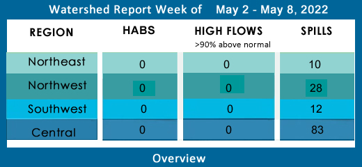
Central NY Watersheds
emptying into Atlantic Ocean at Long Island Sound
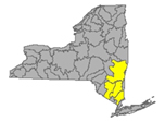
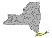
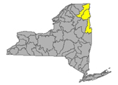
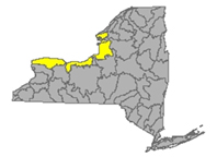
Upper Hudson River Watershed
The Upper Hudson River Watershed drains the south side of the Adirondack Mountains, originating on Mt. Marcy and flowing south; the watershed management area extends to the Albany-Rensselaer County line. From the confluence of the Mohawk River, the Lower Hudson River gathers volume and carries on south to the Atlantic via Long Island Sound tidal estuary.
Including Sacandaga River, Schroon River, Indian River, Fish Creek, Hoosic River, Batten Kill, Great Sacandaga Lake, Indian Lake, Schroon Lake, Saratoga Lake
Flows parts of Essex, Hamilton, Saratoga, Washington, Rensselaer and Warren Counties
- The Upper Hudson River drains an area of 8288 sq miles from headwaters to Albany, flow
- at Newcomb in Essex County is below normal, 38.9% above mean at 497 cfs and 3.02 ft deep (flood stage 12.5 ft);
- at North Creek in Warren County is below normal, 47.2% above mean at 1950 cfs, 5.17 ft deep (flood stage 10ft);
- at Hadley flow is normal, 57.8% above mean at 4330 cfs and 4.88 ft deep (flood stage 14 ft);
- at Fort Edward in Washington County is normal: 80% above mean at 8180 cfs and 22.42 ft deep (flood stage 26 ft);
- at Thomson in Washington County is unrated, 79.7% above mean at 8470 cfs and 21.34 ft deep;
- above Lock 1 near Waterford is flowing normal, 69.5% above mean at 10500 cfs and 21.65 ft deep (flood stage 34 ft). (flow information updated 05-02-22)
- Hudson River 303d listed for iron, aluminum and total phenols, copper, pH, listed in 1998 for PCBs, mercury, recommended for delisting in 2022 due to flawed original analysis
- Vanderwhacker Brook Trib 2 drains an area of .35 sq miles in Essex County before entering the Boreas River system. There are no active monitors on the Boreas, which runs through Essex County and joins the Hudson system. Vanderwhacker Brook is unrated, 15.1% above mean at .18 cfs and .62 ft deep (05-02-22)
- Durgin Brook drains an area of 6.86 sq miles of Essex County before entering the Boreas River system. Flow at Boreas River is unrated, 24.5% above mean flow at 12 cfs and 2.49 ft deep, (05-02-22)
- Indian River drains an area of 132 sq miles in Hamilton County. The flow near Indian Lake is rated above normal at 107.7% above mean flow at 360 cfs and 2.53 ft deep. (05-02-22)
- Schroon River drains an area of 527 sq miles in Warren County; the flow at Riverbank is not rated, registers 4.4 ft deep (flood stage 7ft) (updated 05-02-22)
- Glens Falls Feeder (canal) in Washington County at Dunham Basin is unrated, 3.8% above mean at 3.08 cfs and 2.21 ft deep. (updated 05-02-22)
- Sacandaga River drains an area of 1055 sq miles in Hamilton and Saratoga Counties. The flow near Hope is normal, 106.1% above mean at 3990 and 4.6 ft deep (flood at 7ft); at Stewart’s Bridge near Hadley is flowing much normal, 133.7% above mean at 3450 cfs and 5.09 ft deep (updated 05-02-22)
- Glowegee Creek drains an area of 26 sq miles in Saratoga County. The flow near West Milton is normal, 53.9% above mean, 32.4 cfs, 3.37 ft deep. (updated 05-02-22)
- Batten Kill drains an area of 396 sq miles of Washington County. The flow below Mill at Battenville is normal, 62.7% at 854 cfs and 5.51 ft deep (flood stage 12ft). (updated 05-02-22)
- Hoosic River originates in Massachusetts, flowing north in MA and across New York in a westerly direction before joining the upper Hudson. The Hoosic drains an area of 510 sq miles including Rensselaer County. The flow
- near Williamstown, MA is normal, 53.6% above mean at 244 cfs and 5.8 ft deep;
- at Eagle Bridge is flowing normal, 64.6% above mean at 1060 cfs and 3.99 ft deep (flood stage 11 ft). (updated 05-02-22)
Hoosic River 303d listed in 1998 for PCBs; proposed for de-listing in 2022 for flawed original analysis
Impaired Water Bodies (26)
New and existing Class 5 impaired water bodies (26), by type, County, year of listing and contaminants/concerns in regular text, with 15 of these water bodies proposed for de-listing in whole or in part – see full list under Central tab
Drinking Water Reservoirs on the Impaired List:
- Schaghticoke Reservoir (1102-0015) in Rensselaer County, listed in 2006 for PCBs, recommended for delisting in 2022 for flawed analysis
Spills (12)
Saratoga County (3):
-Equipment failure in Milton caused 5 gallons of transformer oil to be spilled on an unknown resource 04/20/22, unresolved
-Equipment failure in Balston Spa caused 10 gallons of engine oil to be spilled on an unknown resource 04/21/22, unresolved
-Equipment failure in Waterford caused 0.5 gallons of silicone to be spilled on an unknown resource 04/24/22, unresolved
Washington County (2):
-Storm in Putnam Station caused 5 gallons of transformer oil to be spilled in the soil 04/20/22, unresolved
-Deliberate cause in Whitehall caused unknown amounts of hydraulic oil to be spilled in the soil and sewer 04/21/22, unresolved
Warren County (7):
-Storm in Hadley caused 25 gallons of transformer oil to be spilled on an unknown resource 04/20/22, unresolved
-Equipment failure in Hague caused 50 gallons of hydraulic oil to be spilled in the soil 04/20/22, unresolved
-Storm in Chestertown caused 5 gallons of transformer oil to be spilled in the soil 04/21/22, unresolved
-Traffic accident in Lake Luzerne caused 5 gallons of transformer oil to be spilled in the soil 04/23/22, unresolved
-Storm in Balton caused 25 gallons of transformer oil to be spilled in the soil 04/23/22, unresolved
-Deliberate cause in Lake George caused unknown amounts of kerosene to be spilled on an unknown resource 04/24/22, unresolved
-Other cause in Glens Falls caused unknown amounts of other material to be spilled on an unknown resource 04/25/22, unresolved
Hamilton County: None reported
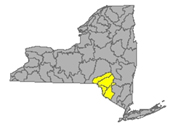
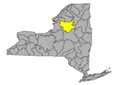
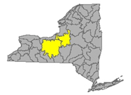
Mohawk River Watershed
The Mohawk River originates in the western Adirondacks and the Tug Hill Plateau and flows 140 miles to the east where it joins the Hudson River. Sections of the Mohawk River also serve as the New York State Barge (Erie) Canal.
Including Schoharie Creek, West Canada Creek, East Canada Creek; Hinkley Reservoir, Delta Reservoir, Peck Lake, and Schoharie Reservoir; joins the Hudson River below Albany.
Flows draining parts of Schenectady, Oneida, Herkimer, Montgomery, and Albany Counties
- Mohawk River drains an area of 3450 sq miles in Oneida, Herkimer, Montgomery, Schenectady, and Albany Counties. The flow
- at Delta Dam near Rome in Oneida County is flowing normal: 62.75% above mean at 280 cfs and 2.46 ft deep;
- near Utica in Herkimer County is unrated, 55.6% above mean at 1050 cfs and 6.21 ft deep;
- at Little Falls is normal, 70% above mean at 3190 cfs and 7 ft deep;
- at Fonda is unrated, 52.65% above mean at 3810 cfs and 12.18 ft deep, 10.6°C;
- at Amsterdam in Montgomery County unrated, 55.3% above mean at 5440 cfs and 11.09 ft deep, 2°C ;
- at Lock 8 near Schenectady in Schenectady County is 10.08 ft deep and 11.3°C with a specific conductance of 267 µS/cm;
- at Freeman’s Bridge in Schenectady County is unrated, flowing 37% above mean at 3640 cfs and 10ft deep (flood stage 20ft);
- at Rexford in Saratoga County the flow is 9.87 ft deep, 11.4°C and 318 µS/cm;
- at Vischer Ferry Dam is 9.81 ft deep;
- at Cohoes in Albany County is flowing below normal, 38.5% above mean at 3450 cfs and 9.92 feet deep above the confluence with the Hudson River (flood stage 20ft). (updated 05-03-22)
Listed 303d for aluminum, copper, low oxygen, fecal coliform, PCBs
- Oriskany Creek drains an area of 144 sq miles in Oneida County into the Mohawk River. The flow at Oriskany is unrated, 67.85% above mean at 299 cfs and 3.47 ft deep (updated 05-02-22)
- Sauquoit Creek drains an area of 59.8 sq miles of Oneida County into the Mohawk River. The flow at Whitesboro is unrated, 64.35% above mean at 100 cfs and 2.42 ft deep. (updated 05-02-22)
Sauquoit Creek 303d listed in 2002 for PCBs, proposed for delisting in 2022 for flawed original analysis
- Moyer Creek drains an area of 18.2 sq miles in Herkimer County. The flow at Frankfort is unrated, 32.1% above mean at 16.2 cfs and 2.54 ft deep. (updated 05-02-22)
- West Canada Creek drains an area of 560 sq miles in Herkimer County into the Mohawk River. The flow near Wilmurt is unrated, 37.1% above mean at 466 cfs and 3.36 ft deep; at Kast Bridge in Herkimer County is rated normal, 70.8% above mean at 1920 cfs and 3.82 ft deep. (updated 05-02-22)
West Canada Creek 303d list: Upper and minor tributaries (1203-008) in Herkimer County, listed in 1998, 2004 for pH
- East Canada Creek drains an area of 289 sq miles of Herkimer County into the Mohawk system. The flow at East Creek in Herkimer is rated normal, 53.3% above mean flow at 720 cfs and 2.55 ft deep (updated 05-02-22)
- Steele Creek drains an area of 26.4 sq miles in Herkimer County into the Mohawk River. The flow at Ilion is unrated, 97.8% above mean at 59.1 cfs and 2.87 ft deep. (updated 05-02-22)
Steele Creek 303d listed in 2004 for total phosphorous; listed in 2004 for silt/sediment, proposed for delisting in 2022 for flawed original analysis
- Fulmer Creek drains an area of 21.7 sq miles of Herkimer County into the Mohawk system. The flow at Mohawk is unrated, 74.7% above mean at 30.6 cfs and 2.32 ft deep. (updated 05-02-22)
- Otsquago Creek drains an area of 61 sq miles in Montgomery County into the Mohawk system. The flow at Fort Plain is normal, 30.6% above mean at 38 cfs and 1.5 ft deep. (updated 05-02-22)
- Canajoharie Creek drains an area of 59.7 sq miles in Montgomery County. The flow at Canajoharie is unrated, 25.7% above mean at 26.2 cfs and 2.08 ft deep (updated 05-02-22)
- Schoharie Creek drains an area of 886 sq miles of Schoharie County flowing north to join the Mohawk River;
- near Lexington is unrated, 45.7% above mean at 175 cfs and 2.83 ft deep;
- at Prattsville is flowing normal, 57.3% above mean at 440 and 4 ft deep (flood at 12ft);
- at Gilboa is flowing normal, % above mean at 701 cfs and 11.7 ft deep (flood stage 17 ft),
- near North Blenheim is unrated, 58.2% above mean at 663 cfs and 3.83 ft deep;
- at North Blenheim is flowing normal, 119.85% above mean at 987 cfs and 3.72 ft deep;
- at Breakabeen is normal, 85.2% above mean at 1060 cfs and 3.17 ft deep (flood stage 11ft);
- at Middleburgh is not rated, 68.6% above mean at 1110 cfs and 6.29 ft deep;
- at Schoharie is 6.63 ft deep;
- at Esperance is 3.21 ft deep;
- at Burtonsville in Schoharie County is normal, 71% above mean, 1380 cfs and 1.93 ft deep. (flood stage 6ft) (updated 05-03-22)
- Fox Creek drains an area of 99 sq miles in Schoharie County. The flow near Schoharie is unrated, 33.4% above mean at 138 cfs and 3.01 ft deep. (updated 05-02-22)
- Little Schoharie Creek drains an area of 18.1 sq miles of Schoharie County. The flow near Middleburgh is unrated, 58.5% above mean at 26.1 cfs and 2.35 ft deep. (updated 05-02-22)
- West Kill drains an area of 27 sq miles in Greene County. The flow near Spruceton is unrated, 71.9% above mean, 18.5 cfs and .82 ft deep; flow at West Kill is unrated, 51.7% above mean at 61.9 cfs and 3.61 ft deep. (updated 05-02-22)
- East Kill drains an area of 35.6 sq miles in Greene County. The flow near Jewett Center is unrated, 51.1% above mean at 77.8 cfs and 3.4 ft deep. (updated 05-02-22)
- Manor Kill drains an area of sq miles in Schoharie County. The flow at West Conesville near Gilboa is normal, 53.6% above mean at 49.4 cfs and 1.38 ft deep. (updated 05-02-22)
- Platter Kill drains an area of 10.9 sq miles in Schoharie County. Flow at Gilboa is above normal, 136.2% above mean at 29.7 cfs and 2.17 ft deep. (updated 05-02-22)
- Mine Kill drains an area of 16.2 sq miles in Schoharie County. The flow at North Blenheim is normal, 78% above mean at 33.6 cfs and 2.36 ft deep. (updated 05-02-22)
- Batavia Kill drains an area of 68.6 sq miles in Greene County before joining with the Schoharie system. The flow at Red Falls near Prattsville is unrated, 55.3% above mean at 138 cfs and 2.52 ft deep. (updated 05-02-22)
- Cobleskill Creek drains an area of sq miles in Schoharie County heads north to join the Mohawk River. The flow at S. Grand Street, Cobleskill is unrated, 47.2% above mean at 141 cfs and 3.94 ft deep. (updated 05-02-22)
- 303d listed in 2004 for fecal coliforms.
Impaired Water Bodies (28)
28 sites proposed in 2020-2022 Draft 303d, for details see list on this site.
Schoharie Reservoir receives rainfall and snowmelt run-off from an area of 315 sq miles in Schoharie County. Schoharie Reservoir (1202-0012), lake/reservoir in Greene County, listed in 1998 for silt/sediment; recommended for de-listing in 2022 for flawed original analysis
Spills (12)
Montgomery County (2):
-Equipment failure in Amsterdam caused 10 gallons of hydraulic oil to be spilled in the soil 04/21/22, unresolved
-Equipment failure in Amsterdam caused 9 gallons of hydraulic oil to be spilled on an unknown resource 04/21/22, unresolved
Schoharie County (0)
Herkimer County (1):
-Unknown cause in Ohio caused unknown amounts of unknown hazardous material to be spilled in the soil and surface water 04/22/22, unresolved
Greene County (1):
-Other cause in Test caused unknown amounts of diesel to be spilled in the soil 04/20/22, resolved 04/20/22
Schenectady County (6):
-Unknown cause in Glenville caused unknown amounts of unknown petroleum to be spilled on an unknown resource 04/20/22, unresolved
-Equipment failure in Rotterdam caused 5 gallons of diesel to be spilled in the soil 04/21/22, resolved 04/21/22
-Equipment failure in Schenectady caused 7 gallons of hydraulic oil to be spilled on an unknown resource 04/21/22, unresolved
-Human error in Schenectady caused 7 gallons of diesel to be spilled on an unknown resource 04/21/22, unresolved
-Unknown cause in Rotterdam caused unknown amounts of gasoline to be spilled on an unknown resource 04/22/22, unresolved
-Equipment failure in Rotterdam Junction caused unknown amounts of gasoline to be spilled in the soil 04/22/22, unresolved
Fulton County (2):
-Storm in Broadalbin caused 2 gallons of transformer oil to be spilled on an unknown resource 04/20/22, unresolved
-Storm in Broadalbin caused 2 gallons of non-PCB oil to be spilled in the soil 04/20/22, unresolved
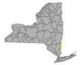
Lower Hudson River Watershed –
The Lower Hudson Watershed begins where the Mohawk River joins the Hudson system at the Troy Dam and extends down to Manhattan. The lower end of the Hudson system, 153 miles, is technically a tidal estuary, not a river.
Rondout/Wallkill Rivers, Stockport/Kinderhook Creeks, Catskill Creek, Esopus Creek, Croton River; Ashokan Reservoir, Rondout Reservoir, New Croton Reservoir, Alcove Reservoir, Cross River Reservoir, Muscoot/Upper New Croton Reservoir
Flows catching parts of Albany, Rensselaer, Dutchess, Columbia, Ulster Counties
- Lower Hudson River drains the bottom end of a total area more than 12,600 sq miles in New York State.
- At Green Island in Albany County, the Hudson is flowing normal, 70.85% above mean at 17400 cfs and 17.03 ft deep (flood stage 21.5);
- at Albany is 5.05 ft deep (flood stage 11 ft) 11.5°C;
- at Port of Albany, flow is reporting 4.77 ft deep, 11.1°C and 195 µS/cm;
- the tidal estuary near Poughkeepsie station in Dutchess County flow is 1.17 ft deep, equipment malfunction affecting the specific conductance reading;
- at South Dock at West Point in Orange County is -.61 ft, 8.9°C with specific conductance of 209 µS/cm;
- at Piermont the flow is not rated, -1.13 ft deep (USGS flood stage 4.3 ft) 2°C and 5330 µS/cm (temp and conductivity readings are the same last two weeks) (updated 04-22-22)
Lower Hudson 303d listed in 2022 for Aluminum, Copper, Iron and Total Phenols. A listing in 1998 for PCBs is suggested for delisting in 2022 due to flaws in original analysis.
- Normans Kill drains 168 sq miles of Albany County. The flow
- at Karlsfield is not rated, 8.63 ft deep;
- the flow at Albany is unrated, 40.3% above mean at 89.8 cfs and 3.3 ft deep. (updated 05-02-22)
- Esopus Creek drains an area of 419 sq miles of Ulster County;
- below Lost Clove Rd at Big Indian in Ulster the flow is unrated, 48.8% above mean at 81.9 cfs and 3.55 ft deep;
- at Allaben is normal, 78.7% above mean at 170 cfs and 3.83 ft;
- at Coldbrook is rated normal, 64.5% above historic mean at 591 cfs and 4.83 ft deep (flood 11ft) and 9.2°C;
- near Lomontville is unrated, 20.7% above mean at 59.6 cfs and 2.78 ft deep;
- at Mount Marion is normal, 39.5% above mean at 312 cfs and 13.68 ft deep (flood stage 20 ft). (updated 05-03-22)
Esopus Creek 303d listed in 2012 for turbidity; Esopus Creek, Upper, including minor tributaries (0007) in Ulster County, listed in 1998 for silt/sediment, considered for delisting in 2022 due to flawed original analysis.
- Stony Clove Creek drains an area of 30.9 sq miles in Ulster County before entering the Ashokan Reservoir. The flow below Ox Clove at Chichester is unrated, 62.1% above mean at 72.7 cfs and 2.66 ft deep. (updated 05-03-22)
- Birch Creek drains an area of 12.5 sq miles in Ulster County and enters the Ashokan Reservoir. The flow at Big Indian is unrated, 58 cfs and 3.45 ft deep. (updated 04-22-22)
- Beaver Kill drains an area of sq miles in Ulster County before joining Esopus Creek. The flow at Mount Tremper is unrated, 68.1% above mean at 41.4 cfs and 6.58 ft deep. (updated 05-03-22)
- Woodland Creek drains an area of 20.6 sq miles of Ulster County. The flow
- at Wilmot Way near Woodland is unrated, 5.3 ft deep;
- at Phoenicia is unrated, 60.1% above mean at 47 cfs and 4.32 ft deep. (updated 05-03-22)
- Valatie Kill drains an area of 9.8 sq miles of Rensselaer County before joining the Hudson; the flow near Nassau is above normal, 151% above mean at 29.8 cfs and 2.03 feet deep. (updated 04-22-22)
Valatie Kill 303d listed in 2010 for PCBs, considered for delisting in 2022 due to flaws in the original analysis
- Bush Kill drains an area of 69.3 sq miles of Ulster County before entering the Ashokan Reservoir. The flow below Maltby Hollow Brook at West Shokan is unrated, 79.8% above mean at 49.7 cfs and 2.81 ft deep. (updated 05-03-22)
- Hollow Tree Brook drains an area of 1.95 sq miles in Greene County, joining the Stony Clove Brook and entering Ashokan Reservoir. The flow at Lanesville is unrated, 66.9% above mean at 5.3 cfs and 2.42 ft deep. (updated 05-03-22)
- Myrtle Creek drains an area of 1.81 sq miles in Greene County. Flow at Edgewood is unrated, 37.3% above mean at 4.68 cfs and 4.12 ft deep. (updated 05-03-22)
- Warner Creek drains an area of 8.71 sq miles in Ulster County. Flow at Chichester is unrated, 74.2% above mean at 26.2 cfs and 1.69 ft deep. (updated 05-03-22)
- Kinderhook Creek drains an area of 329 sq miles in Columbia County before joining the Hudson River. The flow at Rossman is normal, 86.4% above mean at 585 cfs and 3.24 ft deep. (updated 05-03-22)
- Wappinger Creek drains an area of 181 sq miles of Dutchess County; the flow at Wappinger Falls is normal, 99.3% above mean at 325 cfs and 4 ft deep (flood stage 8ft) (updated 05-03-22)
- Rondout Creek drains an area of 383 sq miles in Ulster County;
- at Lowe’s Corners is normal, 64.8% above mean at 88.1 cfs and 3.09 ft deep;
- at Rosendale is normal, 71.5% above mean at 506 cfs and 9.87 ft deep (flood stage 18 ft)(updated 05-03-22)
- Chestnut Creek drains an area of 20.9 sq miles in Sullivan County. The flow at Grahamsville is below normal at 51% above mean at 25.2 cfs and 1.01 ft deep. (updated 05-03-22)
- Croton River drains an area of 378 sq miles of Westchester County into the Croton Reservoir for the New York City water supply. The flow at New Croton Dam near Croton-on-Hudson is rated above normal at 163.2% above mean at 821 cfs and 3.09 ft deep. (updated 05-03-22)
Croton Reservoir 303d listed in 2018 for low dissolved oxygen and total phosphorous in excess of standard
- West Branch Croton River drains 80.4 sq miles of the Croton River basin in Westchester County. The flow
- at Richardsville, is unrated, 69.9% above historic mean at 17.7 cfs and 1.37 ft deep;
- below dam near Kent Cliffs is unrated, 91.25% above historic mean at 41.6 cfs and 1.85 ft deep;
- near Carmel flow is 211.7% above historical mean flow at 81.3 cfs and 1.73 ft deep;
- near Croton Falls is unrated, 155.35% above historical mean flow at 298 cfs and 4.15 ft deep (updated 05-03-22)
- East Branch Croton River drains an area of 81 sq miles of the Croton River basin in Westchester County. The flow
- near Putnam Lake is unrated, 81% above historic mean at 118 cfs and 4.3 ft deep;
- at Brewster is unrated, flowing 119.5% above historic mean at 187 cfs and 3.73 ft deep;
- at Croton Falls is 54.2% above mean at 61.6 cfs and 1.69 ft deep (updated 05-03-22)
- Horse Pound Brook drains an area of 3.94 sq miles in Putnam County, east of the Hudson River, into the New Croton Reservoir. The flow near Lake Carmel is 63.7% above mean at 6.17 cfs and .81 ft deep. (updated 05-03-22)
- Cross River drains an area of 29.9 sq miles of the Croton River basin in Westchester County. The flow
- near Cross River is 73.6% above mean at 29.5 cfs and 2.29 ft deep,
- at Katonah is 84.7% above historic mean at 57.3 cfs and 1.73 ft deep. (updated 05-03-22)
- Titicus River drains an area of 23.8 sq miles of the Croton River basin in Westchester County. The flow
- at Salem Centre is unrated, 91.9% above mean at 24.5 cfs and 2.22 ft deep;
- at Purdys Station is unrated: 47% above mean at 26.6 cfs and 1.96 ft deep; (updated 05-03-22)
- Muscoot River drains an area of 19.7 sq miles of the Croton River basin in Westchester County into the Croton River and New Croton Reservoir. The flow
- below dam at Amawalk is unrated, 78.4% above mean at 30.4 cfs and 8.8 ft deep;
- at Baldwin Place is 79.5% above historical mean at 21.8 cfs and 4.35 ft deep. (updated 05-03-22)
Muscoot River 303d listed in 2018 for ammonia and low dissolved oxygen
- Wallkill River drains an area of 695 sq miles in Ulster County. The flow at Gardiner is normal, 91% above mean at 1110 cfs and 6 ft deep (flood stage 13 ft) (updated 05-03-22)
Wallkill River 303d listed in 2022 for pH, and 2018 for total phosphorous.
Impaired Water Bodies (80)
80 distinct water bodies appear on the new Draft list in the Lower Hudson River Watershed. Note that each lake/reservoir or section of creek/river may have multiple impairments listed, and each impairment has its own line in the official list, but for our purposes here, we count an impaired water body once. Of the 80 listed, 8 are reservoirs; 14 sites have been put forward for one or more contaminants being delisted. See full listing at wtny.us
- Wiccopee Reservoir (0153) in Putnam County, listed in 2022 for iron in excess of standards
- Melzingah Reservoir (0183) in Dutchess County, listed in 2022 for iron
- Vly Creek Reservoir (0234) in Albany County, listed in 2022 for low dissolved oxygen
- Croton Falls Reservoir minor tributaries (0001) in Putnam County
- Browns Pond Reservoir (0013) in Orange County, listed in 2018 for total phosphorous
- Beacon/Cargill Reservoir (0017) in Putnam County, listed in 2022 for dissolved oxygen, iron and pH
- Ashokan Reservoir (0004) in Ulster County, listed in 1998 for silt/sediment is now considered for delisting in 2022 due to flawed original analysis
- Basic Creek Reservoir (0001) in Albany County, listed in 2022 for low dissolved oxygen
- Watervliet Reservoir (0001) in Albany County listed in 2018 for low dissolved oxygen, listed in 2022 for iron and manganese
Spills (12)
Westchester County (7):
-Equipment failure in White Plains caused 15 gallons of jet fuel to be spilled on an impervious surface 04/20/22, resolved 04/20/22
-Storm in Crompond caused unknown amounts of raw sewage to be spilled in the soil and surface water 04/21/22, resolved 04/21/22
-Equipment failure in Ossining caused 0.25 gallons of dielectric fluid to be spilled in the soil 04/21/22, resolved 04/21/22
-Equipment failure in Mount Pleasant caused 1 gallon of dielectric fluid to be spilled in the soil 04/21/22, unresolved
-Equipment failure in White Plains caused 15 gallons of hydraulic oil to be spilled on an impervious surface 04/21/22, resolved 04/21/22
-Equipment failure in New Rochelle caused unknown amounts of #2 fuel oil to be spilled in the soil 04/22/22, unresolved
-Equipment failure in Rye caused unknown amounts of transformer oil to be spilled in the soil and impervious surface 04/22/22, resolved 04/22/22
Putnam County (1):
-Equipment failure in Patterson caused unknown amounts of #2 fuel oil to be spilled in the soil 04/25/22, unresolved
Columbia County (3):
-Traffic accident in Livingston caused 30 gallons of transformer oil to be spilled in the soil 04/20/22, unresolved
-Equipment failure in Hudson caused unknown amounts of gasoline to be spilled in the soil 04/25/22, unresolved
-Equipment failure in Tivoli caused unknown amounts of #2 fuel oil to be spilled in the soil 04/25/22, unresolved
Rensselaer County (1):
-Equipment failure in Poestenkill caused unknown amounts of #2 fuel oil to be spilled in the soil 04/20/22, unresolved
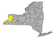
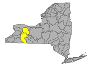
Delaware River Watershed
Delaware River headwaters flow down from the Catskill Mountains into Delaware Bay/Atlantic Ocean. The watershed area includes East Branch Delaware River, West Branch Delaware River, Neversink River, Mongaup River, Pepacton Reservoir, Cannonsville Reservoir and Neversink Reservoir.
Flows streaming over parts of Delaware, Ulster, Sullivan Counties
- East Branch Delaware River drains an area of 458 sq miles in Delaware County. The flow
- at Roxbury is unrated, 65.7% above mean at 26.4 cfs and 3.62 ft deep;
- at Margaretville is normal, 82% above mean at 362 cfs and 3.43 ft deep (flood stage 11ft) 8.8°C and 72 µS/cm;
- at Downsville in Delaware County reporting normal, 120.3% above mean, 576 cfs and 3.8 ft deep (flood stage 9ft) 5.5°C;
- at Harvard, flow is above normal, 142.2% above mean at 984 cfs and 4.18 ft deep, (flood stage 10 ft) 6.4°C;
- at Fishs Eddy is normal, 100.8% above mean at 1730 cfs and 5.93 ft deep, (flood stage 13 ft) 8.5°C; (updated 05-03-22)
- West Branch Delaware River drains an area of 595 sq miles of Delaware County. The flow
- at Hobart is unrated, 93.5% above mean at 31 cfs and 1.12 ft deep;
- upstream from Delhi is normal, 70% above mean at 213 cfs and 2.81 ft deep (flood stage 8ft);
- at Walton in Delaware County is below normal, 53.7% above mean at 410 cfs and 4.77 ft deep, (flood stage 9.5) 10.8°C and 100 µS/cm;
- at Stilesville in Delaware County is above normal, 171.4% above mean at 1360 cfs and 8.78 ft deep and 6.1°C;
- at Hale Eddy in Delaware County is above normal, 143.7% above mean flow at 1600 cfs and 4.53 ft deep, (flood stage 11 ft) 6.8°C; (updated 05-03-22)
- West Brook drains an area of sq miles in Delaware County. The flow at Austin Lincoln Park at Walton is unrated, 52.5% above mean at 38 cfs and 3.87 ft deep. (updated 05-03-22)
- Town Brook drains 14.3 sq miles in Delaware County. The flow southeast of Hobart is unrated, 67.4% above historic mean, 22.1 cfs and 1.47 ft (flood stage 7 ft) (updated 05-03-22)
- Dry Brook drains an area of 82.2 sq miles in Delaware County. The flow at Arkville is unrated, 96.3% above mean at 221 cfs and 2.43 ft deep. (flood stage 10.5 ft) (updated 05-03-22)
- Trout Creek drains an area of 20.2 sq miles in Delaware County direct to the Delaware River. The flow at Trout Creek is normal, 108% above mean, 48.8 cfs and 3.47 ft deep (flood stage 6.3 ft). (updated 05-03-22)
- Little Delaware River drains an area of 49.8 sq miles in Delaware County into the Delaware River. The flow near Delhi is below normal, 37.9% above mean at 45.6 cfs and 2.61 ft deep. (updated 05-03-22)
- Platte Kill drains an area of 34.9 sq miles in Delaware County. The flow at Dunraven is normal, 125.65% above mean at 125 cfs and 3.34 ft deep (flood stage 7ft) (updated 05-03-22)
- Beaver Kill drains an area of 241 sq miles in Delaware County. The flow at Cooks Falls is normal, 78.3% above mean at 581 cfs and 2.92 ft deep, (flood stage 10 ft) 9°C. (updated 05-03-22)
- Tremper Kill drains an area of 33 sq miles of Delaware County; the flow at Andes is unrated, under review or revision, 2.98 ft deep, 8.6°C and 78 µS/cm (updated 05-03-22)
- Mill Brook drains an area of 25.2 sq miles in Delaware County. The flow at Dunraven is normal, 71% above mean at 56.5 cfs and 3.33 ft deep, 8°and 35 µS/cm (updated 05-03-22)
- Neversink River drains an area of 93 sq miles in Ulster, Orange, and Sullivan Counties. Neversink River
- near Claryville in Sullivan County is normal, 81.9% above mean at 226 cfs and 6.65 ft deep, 7.4°C and 23 µS/cm;
- at Neversink is flowing above normal, 273.3% above mean at 265 cfs and 3.82 ft deep, 6.5°C and 27 µS/cm;
- at Bridgeville is not rated, 101.1% above mean at 284 cfs and 5.42 ft deep (flood stage 13 ft), 8.4°C and 65 µS/cm;
- at Godeffroy in Orange County is normal, 94.8% above mean at 542 cfs and 4.09 ft deep (flood stage 10ft), 10.5°C and 92 µS/cm. (updated 05-03-22)
- West Branch Neversink River drains an area of 33.8 sq miles in Sullivan County.
- At Winnisook Lake near Frost Valley headwaters, the flow is unrated, 54.8% above mean at 2.24 cfs and 1.35 ft deep, 5.5ºC and 14 µS/cm;
- at Claryville the flow is unrated, 71.2% above mean at 92.2 cfs and 6.27 ft deep, 7.5°C and 27 µS/cm (updated 05-03-22)
- East Branch Neversink River drains an area of 22.9 sq miles in Ulster County. The flow
- northeast of Denning flow is not rated, 58.3% above mean at 23.5 cfs and 1.38 ft deep, 5.9°C and 12 µS/cm;
- near Claryville is not rated, 72.7% above mean at 62.8 cfs and 5.06 ft deep, 6.8°C and 20 µS/cm; (updated 05-03-22)
- Delaware River drains an area of 1820 sq miles of Delaware County and across the state line to empty into. The flow
- at Lordville is unrated, 104.1% above mean at 3660 cfs and 8.06 ft deep, (flood stage 20 ft) 8.4°and 75 µS/cm;
- at Callicoon is normal, 97.2% above mean at 3940 cfs and 4.42 ft deep, (flood stage 12 ft) 9.7ºC and 68 µS/cm;
- near Barryville is normal, 106.9% above mean at 4820 cfs and 4.87 ft deep (flood stage 17ft) 11.1°C;
- at Port Jervis the flow is normal, 91.8% above mean at 5870 cfs and 6.37 ft deep; (flood stage 18 ft) 11.7°C and 85 µS/cm. (updated 05-03-2022)
- Callicoon Creek drains an area of 110 sq miles in Sullivan County. The flow at Callicoon is normal, 97.2% above mean at 3940 cfs and 4.42 ft deep (flood stage 7ft) 10°C, 74 µS/cm (updated 05-03-2022)
- Mongaup River drains an area of 200 sq miles in Sullivan County. The flow
- near Mongaup Valley is unrated, 98.5% above mean at 157 cfs and 3.48 ft deep (flood stage 14ft),
- near Mongaup flow is below normal, 40.3% above mean at 182 cfs and 1.73 ft deep, 10.3°C and 124 µS/cm (updated 05-03-2022)
Impaired Water Bodies (25)
25 Water bodies appear on the latest Draft 303(d) list for the Delaware River watershed in 2022, with 2 suggestions for delisting, in whole or in part.
For more details, check out the posted list under the Delaware tab.
Spills (12)
Sullivan County (2):
-Equipment failure in Thompson caused unknown amounts of gasoline to be spilled in the soil and ground water 04/21/22, unresolved
-Equipment failure in Glen Spey caused 10 gallons of hydraulic oil to be spilled in surface water 04/22/22, resolved 04/28/22
Delaware County (7):
-Storm in Delhi caused 2 gallons of transformer oil to be spilled in the soil 04/21/22, unresolved
-Traffic accident in Deposit caused unknown amounts of diesel to be spilled on an unknown resource 04/21/22, unresolved
-Traffic accident in Davenport Center caused 3000 gallons of other material to be spilled on an unknown resource 04/21/22, unresolved
-Storm in deposit caused 2 gallons of transformer oil to be spilled in the soil 04/21/22, unresolved
-Traffic accident in Deposit caused 5 gallons of transformer oil to be spilled in the soil 04/22/22, unresolved
-Unknown cause in Unadilla caused unknown amounts of motor oil to be spilled in the soil and surface water 04/22/22, unresolved
-Storm in Walton caused 10 gallons of transformer oil to be spilled in the soil 04/22/22, unresolved
Ulster County (3):
-Equipment failure in Kingston caused unknown amounts of other material to be spilled on an unknown resource 04/21/22, unresolved
-Equipment failure in Woodstock caused 5 gallons of #2 fuel oil to be spilled in the soil 04/21/22, unresolved
-Other cause in Olive caused unknown amounts of unknown material to be spilled into the air 04/23/22, unresolved
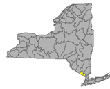
Housatonic River Watershed
A small portion of the headwaters of the Housatonic lies in eastern New York State. These waters drain the Taconic and Berkshire Mountains before joining the Housatonic and eventually emptying into Long Island Sound. Includes Tenmile River, Green River, Indian Lake, Swift/Crane Ponds
Flows: parts of Dutchess County
- Housatonic River drains an area of 282 sq miles in Dutchess County. The river itself is not located in New York state, but it does receive run-off from Dutchess County; near Great Barrington, MA is flowing normal, 64.3% above mean at 492 cfs and 2.76 ft deep; (05-03-22)
- Green River drains an area of 51 sq miles of Dutchess County. The flow near Williamstown, MA is normal, 69% above mean at 91.5 cfs and 2.38 ft deep; at Great Barrington is above normal, 49.5% above historic mean at 67.7 cfs and 1.12 ft deep. (updated 05-03-22)
Impaired Water Bodies (0)
Spills (3)
Dutchess County:
-Equipment failure in Poughkeepsie caused 100 gallons of raw sewage to be spilled on an unknown resource 04/20/22, unresolved
-Equipment failure in Poughkeepsie caused 30 lbs of freon to be spilled into the air 04/21/22, resolved 04/21/22
-Other cause in Beacon caused unknown amounts of sealants to be spilled into the soil 04/25/22, resolved 04/25/22
Ramapo River Watershed
The northern headwaters of the Passaic basin lie within a small portion of southeastern New York State, including the Ramapo and Hackensack Rivers drainage areas. It is the smallest watershed in New York State. Including Ramapo River, Hackensack River, Greenwood Lake, and DeForest Lake.
Flows: concerned with parts of Rockland and Orange Counties
- Mahwah River drains an area of 12 sq miles in Rockland. The flow near Suffern is normal, 66.1% above historical mean at 18.1 cfs and 2.04 feet deep (flood stage 5ft) (updated 05-03-22)
- Ramapo River drains an area of 93 sq miles in Rockland County. The flow
- at Ramapo is normal, 76% above mean at 145 cfs and 2.55 ft deep (flood stage is 10 ft);
- near Mahwah NJ is normal, 82.9% above mean at 215 cfs and 3.52 ft deep (flood stage 8ft);
- at Suffern, normal, 62.5% above mean, 124 cfs and 2.98 ft deep (flood stage is 15.2ft) (updated 05-03-22)
- Hackensack River drains an area of 30.7 sq miles in Rockland County. The flow at West Nyack is normal, 46.2% above historical mean flow at 19.9 cfs and 2.74 ft deep. (updated 05-03-22)
Impaired Water Bodies (14)
14 Water bodies appear on the Draft 303(d) list for the Ramapo River watershed in 2022, with 5 proposed for delisting, in whole or in part.
For more details, check out the posted list under the Ramapo tab.
Spills (10)
Rockland County (5):
-Unknown cause in Blauvelt caused unknown amounts of cooking grease to be spilled on an unknown resource 04/20/22, resolved 04/20/22
-Traffic accident in Congers caused unknown amounts of transformer oil to be spilled on an unknown resource 04/20/22, unresolved
-Traffic accident in New City caused 1 gallon of non-PCB oil to be spilled in the soil 04/20/22, unresolved
-Equipment failure in Pomona caused unknown amounts of #2 fuel oil to be spilled in the soil 04/22/22, unresolved
-Equipment failure in Fredonia caused unknown amounts of transformer oil to be spilled on an unknown resource 04/25/22, unresolved
Orange County (5):
-Traffic accident in Slate Hill caused 2 gallons of transformer oil to be spilled in the soil 04/20/22, unresolved
-Equipment failure in Monroe caused 0.25 gallons of hydraulic oil to be spilled in the soil 04/21/22, resolved 04/21/22
-Equipment failure in Washingtonville caused 1 gallon of transformer oil to be spilled in the soil 04/21/22, resolved 04/21/22
-Human error in Montgomery caused 0.25 gallons of other material to be spilled in the soil 04/22/22, resolved 04/22/22
-Equipment failure in Port Jervis caused unknown amounts of diesel to be spilled in the soil 04/22/22, unresolved
Atlantic Ocean/Long Island Sound Watershed
The Atlantic Ocean/Long Island Sound Watershed drains most of the New York City Metropolitan Area and all of Long Island. The drainage area includes all marine waters in New York Harbor, Long Island Sound, Block Island Sound, and along the South Shore of Long Island, and the fresh waters that drain into them.
Includes 1415 square miles of marine estuary waters, the Bronx River, Mamaroneck River, Mianus River, Peconic River, Kensico Reservoir, Lake Ronkonkoma.
Flows taking in run-off from parts of Bronx, Queens, Kings, Suffolk, Nassau and New York Counties
- Bronx River drains an area of 38.4 sq miles of Bronx County. The flow at NY Botanical Garden is unrated, 47.5% above mean at 50.9 cfs and .73 ft deep (flood stage 3ft) 13.4°C and 980 µS/cm (updated 05-03-22)
- Valley Stream drains 3.77 sq miles in Nassau County. The flow at Valley Stream has been monitored for 65 years. This week flow is above normal, 203.7% above mean at 5.99 cfs and 1.14 ft deep. (reading same as last week) (updated 05-03-22)
- East Meadow Brook drains an area of 28.7 sq miles of Nassau County. The flow at Freeport is below normal, 26% above mean at 4.17 cfs and .38 ft deep (updated 05-03-22)
- Massapequa Creek drains an area of 38.6 sq miles in Nassau County. The flow at Massapequa is below normal, 33.2% below mean at 4.05 cfs and .69 ft deep. (updated 05-03-22)
- Carlls River drains an area of 35.4 sq miles in Suffolk County. The flow at Babylon is normal; 23.2 cfs and .68 ft deep. (updated 05-03-22)
- Sampawams Creek drains an area of 22.7 sq miles in Suffolk County. The flow at New Babylon is below normal, 43.4% above mean at 5.36 cfs and .6 ft deep (updated 05-03-22)
- Bellmore Creek tributary drains less than 1 sq mile in Suffolk County. The flow near Bellmore is below normal, % above mean at .91 cfs and 2.15 ft deep. (05-03-22)
- Connetquot Brook drains an area of 21.9 sq miles in Suffolk County. The flow at Central Islip is normal: 113.8% above mean at 35.9 cfs and 3.09 ft deep. (updated 05-03-22)
- Swan River drains an area of 8 sq miles in Suffolk County. The flow at East Patchogue is normal, 100.3% above at 14.1 cfs and .56 ft deep. (flow volume and depth are the same as last two weeks) (updated 05-03-22)
- Carmans River drains an area of 73 sq miles in Suffolk County. The flow at Yaphank is normal, 81.65% above mean at 22.6 cfs and 1.2 ft deep (05-03-22)
- Peconic River drains an area of 74.7 sq miles of Suffolk and Nassau Counties. The flow
- at Riverhead is normal: 61.6% above mean at 29.9 cfs and .45 ft deep;
- at County Hwy 105 is not rated, 1.5 ft deep (flood stage 4.44 ft) 14°C and 39400µS/cm (updated 05-03-22)
- Mill Neck Creek drains an area of 8.58 sq miles of Nassau County. The flow at Mill Neck is normal, 97% above mean at 9.29 cfs and .23 feet deep. (updated 05-03-22)
- Cold Spring Brook drains an area of 7.83 sq miles in Nassau County. The flow at Cold Spring Harbour is normal, 104.2% above mean at 3 cfs and .27 ft deep (updated 05-03-22)
- Nissequogue River drains an area of 27 sq miles in Nassau County. The flow at Smithtown is normal, 92.7% above mean at 45.2 cfs and .72 ft deep, 14.2ºC and 250µS/cm (updated 05-03-22)
Impaired Water Bodies (200)
200 water bodies appear on the Draft 303(d) list for the Atlantic Ocean/Long Island Sound watershed in 2020-2022, up from 49 sites on the 2018 list. Of the 200, 49 are proposed for delisting, in whole or in part.
For more details, check out the posted list under the Atlantic/LIS tab.
Spills (22)
New York County (3) (Manhattan):
-Equipment failure in Manhattan caused 3 gallons of hydraulic oil to be spilled in the sewer 04/21/22, resolved 04/22/22
-Equipment failure in Manhattan caused unknown amounts of nitric oxide to be spilled into the air 04/21/22, resolved 04/25/22
-Human error in Manhattan caused unknown amounts of mercury to be spilled on an unknown resource 04/24/22, unresolved
Kings County (Brooklyn): None reported
Queens County (4):
-Equipment failure in Long Island City caused unknown amounts of gasoline to be spilled on an unknown resource 04/20/22, unresolved
-Equipment failure in Queens caused 10 gallons of hydraulic oil to be spilled in the soil 04/21/22, resolved 04/22/22
-Equipment failure in Jamaica caused 6lbs of hydraulic oil to be spilled on an unknown resource 04/21/22, unresolved
-Abandoned drums in Queens caused unknown amounts of waste oil to be spilled on an unknown resource 04/23/22, resolved 04/25/22
Nassau County (4):
-Equipment failure in Freeport caused 10 gallons of #2 fuel oil to be spilled in the soil and impervious surface 04/20/22, unresolved
-Equipment failure in East Meadow caused 10 gallons of #2 fuel oil to be spilled in the soil and impervious surface 04/20/22, unresolved
-Equipment failure in merrick caused 5 gallons of #2 fuel oil to be spilled on an impervious surface 04/21/22, unresolved
-Equipment failure in Great Neck caused unknown amounts of transformer oil to be spilled in the soil and impervious surface 04/25/22, unresolved
Suffolk County (6):
-Equipment failure in Bay Shore caused 120 gallons of gasoline to be spilled in drinking water 04/20/22, unresolved
-Unknown cause in East Patchogue caused unknown amounts of cooking grease to be spilled in the sewer 04/20/22, resolved 04/20/22
-Deliberate cause in Shoreham caused unknown amounts of unknown material to be spilled in the soil 04/20/22, unresolved
-Unknown cause in Mastic Beach caused unknown amounts of #2 fuel oil to be spilled in the soil and impervious surface 04/20/22, unresolved
-Unknown cause in North Babylon caused unknown amounts of #2 fuel oil to be spilled in the soil and groundwater 04/20/22, unresolved
-Equipment failure in Shelter Island caused 1 gallon of transformer oil to be spilled in the soil 04/21/22, unresolved
Richmond County (3):
-Unknown cause in Staten Island caused unknown amounts of waste oil to be spilled in the soil 04/20/22, unresolved
-Equipment failure in Staten Island caused 1 gallon of dielectric fluid to be spilled in the soil 04/22/22, unresolved
-Equipment failure in Staten Island caused unknown amounts of transformer oil to be spilled on an unknown resource 04/23/22, unresolved
Bronx County (2):
-Storm in Bronx caused unknown amounts of raw sewage to be spilled in the surface water 04/25/22, resolved 04/25/22
-Equipment failure in Bronx caused unknown amounts of #2 fuel oil to be spilled on an unknown resource 04/25/22
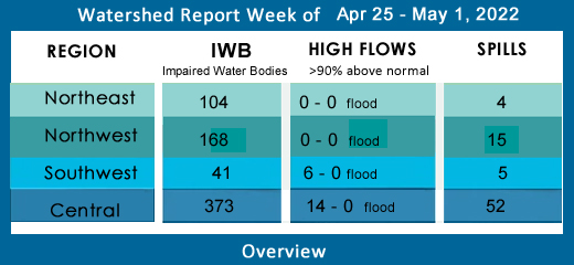
Northeast Watersheds
emptying into Atlantic Ocean via St. Lawrence River
Lake Champlain Watershed
The Lake Champlain Watershed drains the area between the Adirondack Mountains in northeastern New York State and the Green Mountains in northwestern Vermont.
Includes the Ausable River, Saranac River, Great Chazy River, Boquet River, Mettawee River, Ticonderoga Creek/Lake George, Lake George,
Upper Saranac Lake, Lower Saranac Lake, Lake Placid, Lake Champlain
Flows concerning parts of Washington, Essex, and Clinton Counties
- Mettawee River drains an area of 167 sq miles of Washington County into Lake Champlain. The flow near Middle Granville is normal, 70% above mean at 289 cfs and 4.21 feet deep (flood stage 7 ft) (updated 05-03-22)
- Boquet River drains an area of 207 sq miles of Essex County. The flow at Willsboro is below normal, 52.5% above mean, 387 cfs and 3.17 ft deep. (updated 05-03-22)
- Ausable River drains an area of 198 sq miles of Clinton County. The flow near Au Sable Forks is below normal, 46.3% above mean at 941 cfs and 2.57 ft deep (updated 05-03-22)
- East Branch Ausable River drains an area of 198 sq miles in Essex County. The flow at Au Sable Forks is below normal, 37.3% above mean at 413 cfs and 2.32 ft deep; (updated 05-03-22)
- Little Ausable River near Valcour is unrated, 61.8% above mean at 60.4 cfs and 1.64 ft deep. (updated 05-03-22)
- Salmon River drains an area of 63 sq miles in Clinton County. The flow at South Plattsburgh is normal, 66.8% above mean at 67.1 cfs and 1.35 ft deep (updated 05-03-22)
- Saranac River drains an area of 608 sq miles. The flow at Plattsburgh is normal, 70.9%above mean at 1310 cfs and 4.5 ft deep (flood stage 9ft) (updated 05-03-22)
- Great Chazy River drains an area of 243 sq miles in Clinton County. The flow at Perry Mills is normal, 54% above mean at 319 cfs and 2.71 ft deep, (flood stage 9ft) (updated 05-03-22)
- Little Chazy River drains an area of 50 sq miles in Clinton County. The flow near Chazy is normal, 48.6% above mean at 57.6 cfs and 2.53 feet deep. (updated 05-03-22)
Impaired Water Bodies (29)
29 water bodies appear on the 2022 Draft 303(d) list for Lake Champlain Watershed up from 6 in the last list. Of the 29 total, 12 water bodies are proposed for delisting, in whole or in part.
For more details, check out the posted list under the NE tab.
Spills (2)
Clinton County (1):
-Equipment failure in Champlain caused unknown amounts of kerosene to be spilled on an unknown resource 04/25/22, unresolved
Essex County (1):
-Storm in Keeseville caused 5 gallons of transformer oil to be spilled in the soil 04/20/22, unresolved
St. Lawrence River Watershed
185 km of the St. Lawrence River catches the runoff from the northern and western Adirondack Mountains, drawing from portions of eight states, a combined area of 5600 square miles.
St. Lawrence Watershed collects the flow from eleven thousand miles of freshwater rivers and streams, including the Oswegatchie River, Raquette River, Saint Regis River, Grass River and Indian River; including Black Lake, Cranberry Lake, Raquette Lake, Tupper Lake and Long Lake. Densely forested woodlands, peatlands and areas of flat agricultural plains make up the natural surface water filtration system of this watershed area.
Flows: parts of St. Lawrence and Franklin Counties
- Raquette River drains 1125 sq miles of St. Lawrence County. The flow
- at Piercefield is normal, 71.5% above mean at 2690 cfs and 7.7 ft deep (flood stage 12.5 ft);
- at South Colton is normal, 86.1% above mean at 3370 cfs and 6.07 feet deep (flood stage is 10ft);
- at Raymondville is normal, 74.9% above mean at 3280 cfs and 3.85 ft deep (updated 05-03-22)
- Regis River drains an area of 612 sq miles in St. Lawrence County. The flow at Brasher Centre is normal, 60.8% above mean at 1300 cfs and 6.9 ft deep (floods at 11ft). (updated 05-03-22)
- West Branch St. Regis River drains an area of 171 sq miles in St. Lawrence County. The flow near Parishville is below normal, 62% above mean at 379 cfs and 1.98 ft deep. (updated 05-03-22)
- Little Salmon River drains an area of 92 sq miles of Franklin County. The flow at Bombay is normal, 65.7% above mean at 125 cfs and 3.05 ft deep. (updated 05-03-22)
- Grass River drains an area of 598 sq miles in Franklin County. The flow at Chase Mills is unrated, 34.75% and 627 cfs and 4.88 ft deep. (updated 05-03-22)
- Oswegatchie River drains an area of 986 sq miles in St. Lawrence County. The flow
- at Oswegatchie is below normal, 39% above mean at 331 cfs and 2.73 ft deep;
- at Heuvelton is below normal, 49.05% above mean at 1310 cfs and 2.27 ft deep. (updated 05-03-22)
- West Branch Oswegatchie River drains an area of 258 sq miles in St. Lawrence County. The flow near Harrisville is below normal, 43.7% above mean at 391 cfs and 2.83 ft deep. (updated 05-03-22)
Impaired Water Bodies (41)
41 water bodies appear on the 2022 Draft 303(d) list for St. Lawrence Watershed, up from 4 in the last list. Of the 41 total, 5 are proposed for delisting, in whole or in part.
For more details, check out the posted list under the NE tab.
Spills (2)
Franklin County (1):
-Equipment failure in Tupper Lake caused 10 gallons of kerosene to be spilled in the soil 04/26/22, unresolved
St. Lawrence County (1):
-Deliberate cause in Gouverneur caused unknown amounts of other material to be spilled on an unknown resource 04/24/22, unresolved
Black River Watershed
The Black River headwaters begin in the Adirondack mountains, scoop southwest and then curve northwest, the flow proceeds north-northwest, hooks west and empties into Lake Ontario. Major tributaries in the system include Moose River, Beaver River, Independence River and Deer River, Stillwater Reservoir, Fulton Chain of Lakes, Lake Lila and Big Moose Lake.
Flows: Filters and drains most of Jefferson and Lewis Counties along with parts of Herkimer, Hamilton, and Oneida Counties.
- Black River drains an area of 1864 sq miles of Jefferson County. The flow
- at Boonville is below normal, 46.9% above mean at 668 cfs and 4.97 ft deep (flood stage 10ft);
- at Watertown flow is below normal, 47.9% above mean, 3460 cfs and 4.37 feet deep (flood at 10ft). (updated 05-03-22)
- Beaver River drains 291 sq miles in Lewis County. The flow at Croghan is normal: 79.5% above mean at 650 cfs and 3.11 ft deep. (updated 05-03-22)
- Independence River drains an area of 88.7 sq miles in Lewis County. The flow at Donnatsburgh is below normal, 42.35% above mean at 144 cfs and 3.89 feet deep, 11.2°C (updated 05-03-22)
Impaired Water Bodies (34)
34 water bodies appear on the 2022 Draft 303(d) list for Black River Watershed, up from one in the last list. Of the 34 total, 2 are proposed for delisting in 2022, in whole or in part.
For more details, check out the posted list under the NE tab.
Spills (6)
Jefferson County (5):
-Equipment failure in LeRay caused 30 gallons of diesel to be spilled in the soil 04/20/22, unresolved
-Traffic accident in Wilna caused 50 gallons of diesel to be spilled in the soil and surface water 04/21/22, unresolved
-Traffic accident in Wilna caused unknown amounts of diesel to be spilled in the soil and surface water 04/21/22, unresolved
-Unknown cause in Watertown caused unknown amounts of diesel to be spilled in the soil 04/23/22, unresolved
-Equipment failure in Clayton caused 10 gallons of hydraulic oil to be spilled in the soil 04/26/22, unresolved
Lewis County (1):
-Other cause in Lowville caused 4.9 gallons of bentonite to be spilled in the soil 04/26/22, unresolved
Northwest Watersheds
emptying into Atlantic Ocean via Great Lakes and St. Lawrence River
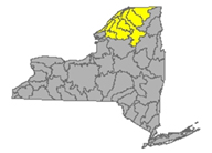
Lake Ontario and Minor Tributaries
This watershed drains 2460 square miles of northwest New York State, including three areas between the Niagara, Genesee, Oswego and Black Rivers) . It is divided into western, central, and eastern sections that stretch all along the Lake Ontario Shoreline.
*Includes Salmon River Reservoir, Sodus Bay, North Pond, Irondequoit Bay and Perch Lake, Salmon River, Oak Orchard Creek, Irondequoit Creek, Sandy Creek
Flows considering most of Jefferson and Orleans Counties, parts of Monroe, Oswego, Wayne and Niagara Counties
- Northrup Creek drains an area of 10.1 sq miles in Monroe County. The flow at North Greece in Monroe County is below normal, 34.5% above mean, 6.52 cfs and 1.11 ft deep and 14.2°C (updated 05-03-22)
- Sandy Creek drains an area of 137 sq miles in Jefferson County. The flow at Adams is normal, 57.7% above mean at 212 cfs and 2.15 ft deep. (updated 05-03-22)
- Salmon River drains 238 sq miles in Oswego County. The flow at Pineville is unrated: 38.9% above mean at 430 cfs and 5.82 feet deep. (updated 05-03-22)
- North Branch Salmon River drains an area of 82.5 sq miles in Oswego County. The flow at Redfield is unrated, 17.3% above mean at 129 cfs and 1.91 ft deep. (updated 05-03-22)
- Eighteenmile Creek drains an area of 84.8 sq miles in Niagara County. The flow at Burt is unrated, 40.3% above historical mean, 108 cfs and 2.91 ft deep, 11.7°C and 876 µS/cm; (updated 05-03-22)
- Oak Orchard Creek drains an area of 202 sq miles in Orleans County. The flow
- near Shelby is unrated, 76.1% above mean at 186 cfs and 7.25 ft deep, 13.2°C and 969 µS/cm;
- at Kenyonville is unrated, 66.7% above mean at 328 cfs and 2.59 ft deep, 14.1°C and 872 µS/cm. (updated 05-03-22)
- Irondequoit Creek drains an area of 142 sq miles in Monroe County. The flow
- near Fishers is unrated, 62.5% above mean at 33.5 cfs and 4.37 ft deep;
- above Blossom Rd. near Rochester is normal, 53.2% above mean at 93.1 cfs and 3.24 ft deep, 1320 µS/cm; (updated 05-03-22)
Impaired Water Bodies
56 water bodies appear on the 2022 Draft 303(d) list for Lake Ontario and minor tributaries Watershed, up from six in the last list. Of the 56 total, 38 are affected by a proposed delisting in 2022, in whole or in part.
For more details, check out the posted list under the NW tab.
Spills (8)
Orleans County (1):
-Unknown cause in Carlton caused unknown amounts of #2 fuel oil to be spilled in the soil 04/22/22, unresolved
Wayne County (3):
-Traffic accident in Ontario caused 20 gallons of hydraulic oil to be spilled on an unknown resource 04/20/22, resolved 04/21/22
-Traffic accident in Macedon caused 5 gallons of motor oil to be spilled in the soil and surface water 04/21/22, unresolved
-Traffic accident in Sodus caused unknown amounts of diesel to be spilled in the soil and #2 fuel oil to be spilled in the soil 04/22/22, unresolved
Oswego County (4):
-Equipment failure in Oswego caused 1.75 gallons of hydraulic oil to be spilled on an unknown resource 04/20/22, resolved 04/20/22
-Equipment failure in Oswego caused unknown amounts of diesel to be spilled on an unknown resource 04/20/22, unresolved
-Equipment failure in Palermo caused unknown amounts of #2 fuel oil to be spilled in the soil 04/22/22, unresolved
-Unknown cause in Cleveland caused unknown amounts of unknown material to be spilled on an unknown resource 04/25/22, unresolved
Niagara River/Lake Erie Watershed
Draining an area encompassing more than 265,000 square miles in the north-central United States and south-central Canada, including Tonawanda Creek, Cattaraugus Creek, Buffalo River; Attica Reservoir and Lime Lake.
Flows: parts of Niagara, Wyoming and Erie Counties
- Niagara River drains an area of 265100 sq miles. The flow at Port Erie is 246.81 ft deep. (updated 05-03-22)
- Tonawanda Creek drains an area of 349 sq miles in Niagara, Genesee and Wyoming Counties. The flow
- at Attica is normal, 71.65% above mean at 95.1 cfs and 3.66 ft deep (flood stage 8ft);
- at Batavia in Genesee County is normal: 1% above mean; today flowing at 205 cfs and 2.36 feet deep (flood stage 9ft);
- at Rapids is normal, 98.9% above mean at 497 cfs and 2.57 ft deep (flood stage 12ft) (updated 05-03-22)
- Ellicott Creek drains an area of 82 sq miles in Niagara County. The flow at Williamsville is above normal, 135.8% above mean at 189 cfs and 2.67 ft deep (flood stage 8ft). (updated 05-03-22)
- Cayuga Creek drains an area of 96 sq miles in Erie County. The flow at Lancaster is flowing normal, 92.1% above mean at 130 cfs and 4.08 ft deep (flood stage 8ft) (updated 05-03-22)
- Cazenovia Creek drains an area of 135 sq miles in Erie County. The flow at Ebenezer is above normal, 110.2% above mean at 240 cfs and 3.24 ft deep. (flood stage 10 ft) (updated 05-03-22)
- Buffalo Creek drains an area of 142 sq miles in Erie County. The flow at Gardenville is above normal, 107.4% above mean at 212 cfs and 1.36 ft deep (flood stage 7ft) (updated 05-03-22)
- Cattaraugus Creek drains an area of 436 sq miles in Erie County. The flow at Gowanda is normal, 111.3% above mean at 916 cfs and 2.72 ft deep, (flood stage 10ft) 10.8°C and 324 µ/cm. (updated 05-03-22)
- Eighteenmile Creek drains an area of 36.6 sq miles in Erie County. The flow
- at Hamburg is unrated, 105.1% above mean at 116 cfs and 3.2 ft deep;
- S Branch flow at Bley Rd at Eden Valley is unrated, 96.2% above mean at 61.5 cfs and 3.68 ft deep. (updated 05-03-22)
- Big Sister Creek drains an area of 48.4 sq miles in Erie County. The flow at Evans Center is unrated, 150% above mean at 99.8 cfs and 3.85 ft deep. (updated 05-03-22)
- Canadaway Creek drains an area of 32.9 sq miles in Cattaraugus County. The flow at Fredonia is unrated, 97.4% above mean at 60.8 cfs and 2.35 ft deep. (updated 05-03-22)
- Chautauqua Creek drains an area of 35 sq miles in Chautauqua County. The flow below Westfield is unrated, 142.1% above mean at 83.1 cfs and 1.1 ft deep (updated 05-03-22)
Impaired Water Bodies (49)
49 water bodies appear on the 2022 Draft 303(d) list for Niagara River and Lake Erie Watershed, up from 11 on the last list. Of the 49 total, 24 are affected by a proposed delisting in 2022, in whole or in part.
For more details, check out the posted list under the NW tab.
Spills (5))
Erie County (3):
-Unknown cause in Tonawanda caused unknown amounts of unknown petroleum to be spilled in the soil and surface water 04/23/22, unresolved
-Housekeeping in Buffalo caused 5 gallons of jet fuel to be spilled on an impervious surface 04/25/22, unresolved
-Equipment failure in Buffalo caused unknown amounts of auto waste fluids to be spilled on an impervious surface 04/26/22, unresolved
Niagara County (2):
-Other cause in Niagara Falls caused 10 gallons of unknown petroleum to be spilled on an impervious surface 04/21/22, unresolved
-Equipment failure in Lockport caused 10 gallons of transformer oil to be spilled in the soil 04/23/22, unresolved
Genesee River Watershed
Genesee River originates in north-central Pennsylvania. The Genesee runs right through New York state, more or less straight north from the south state line up to Lake Ontario at Rochester. The watershed includes the following tributary flows, lakes, and reservoirs: Conesus Lake, Silver Lake, Mount Morris Reservoir, Hemlock Lake, Honeoye Lake; Cassadaga Creek, Honeoye Creek, Oatka Creek, Black Creek
Flows parts of Monroe, Livingston, and Allegany Counties
- Genesee River drains an area of 2474 sq miles in Monroe, Livingston and Allegany Counties. The flow
- at Wellsville in Allegany County is normal, 51.4% above mean at 254 cfs and 4.87 ft deep (flood stage 11 ft);
- at Portageville in Wyoming County is flowing normal, 56.1% above mean at 910 cfs and 9.69 ft deep (flood stage 19ft);
- near Mount Morris in Livingston County is normal, 65.6% above mean at 1590 cfs and 4.49 ft deep;
- at Avon flow is normal, 56.9% above mean at 1540 cfs and 18.73 ft deep (flood stage 33 ft);
- flow is normal near Mortimer is 1830 cfs and 11.93 ft deep;
- at Ford St. Bridge in Rochester, Monroe County, below normal, 39.9% above mean at 1590 cfs and 12.69 ft deep, 12.3°C and 537 µS/cm. (updated 05-03-22)
- Allen Creek drains an area of 28.9 sq miles in Monroe County. The flow near Rochester flow is below normal, 39.2% above mean at 13.2 cfs and 2.48 ft (updated 05-03-22)
- Honeoye Creek drains an area of 196 sq miles of Monroe County. The flow at Honeoye Falls in Monroe County is normal, 92% above mean at 194 cfs and 3.54 ft deep (flood stage 6.5 ft) (updated 05-03-22)
- Conesus Creek drains an area of 72 sq miles in Livingston County. The flow is below normal near Lakeville in Livingston County, 25.15% above mean at 28.6 cfs and .89 ft deep. (updated 05-03-22)
- Canaseraga Creek drains an area of 88.9 sq miles of Livingston County. The flow
- above Dansville is normal, 56.6% above mean at 82 cfs and .89 ft deep;
- at Shakers Crossing in Livingston County is normal, 66.3% above mean at 284 cfs and 4.27 ft deep. (updated 05-03-22)
- Keshequa Creek drains an area of 68.3 sq miles in Livingston County, flowing north to join the Genesee River. The flow at Sonyea is unrated, 82.8% above mean at 48.4 cfs and .73 ft deep. (updated 05-03-22)
- Oatka Creek drains an area of 200 sq miles in Monroe County. The flow
- at Warsaw is normal, 73% above mean at 41.2 cfs and 3.58 ft deep;
- at Garbutt is normal, 72.3% above mean at 208 cfs and 2.94 ft deep (flood stage 6ft). (updated 05-03-22)
- Black Creek drains an area of 130 sq miles in Monroe County. The flow at Churchville is normal: 66% above historic mean for this time of year, at 103 cfs and 2.11 ft deep, (flood stage 6ft,) (updated 05-03-22)
Impaired Water Bodies (23)
23 water bodies appear on the 2022 Draft 303(d) list for Genesee River Watershed, up from 11 in the last list. Of the 23 total, 6 are affected by a proposed delisting in 2022, in whole or in part.
For more details, check out the posted list under the NW tab.
Spills (5)
Livingston County (1):
-Human error in Avon caused 175 gallons of lube oil to be spilled on an unknown resource 04/22/22, unresolved
Allegany County (0)
Monroe County (3):
-Equipment failure in Rochester caused 1 gallon of #2 fuel oil to be spilled on an impervious surface 04/22/22, unresolved
-Equipment failure in Greece caused unknown amounts of unknown petroleum to be spilled in the soil and ground water 04/22/22, unresolved
-Equipment failure in Churchville caused 0.5 gallons of transformer oil to be spilled in the soil 04/24/22, unresolved
Genesee County (1):
-Equipment failure in Pembroke caused 12 gallons of diesel to be spilled on an unknown resource 04/21/22, unresolved
Wyoming County (0)
Oswego River and Finger Lakes Watershed
The Oswego River originates in the Adirondacks, with the combined flows of the Seneca River and many tributaries, drains a large area of northern New York to Lake Ontario. The water bodies found in this drainage basin include the Finger Lakes: Otisco, Skaneateles, Owasco, Cayuga, Oneida, Seneca, Keuka, Canandaigua, and Canadice Lakes; Oneida River, Clyde River, Cayuga Lake Tributaries and Seneca Lake Tributaries
Flows draining parts of Oswego, Madison, Cayuga, Tompkins, Seneca, Onondaga, Yates and Ontario Counties
- Oswego River drains an area of 5100 sq miles of Oswego, Madison, Cayuga, Tompkins, Seneca, Onondaga, Yates and Ontario counties. The flow
- near Phoenix is not rated, 21.8% above historic mean at 2260 cfs and 3.07 ft deep;
- at Lock 7 in Oswego County is below normal, 34.9% above mean at 3500 cfs and 3.8 ft deep, 12.5°C and 692 µS/cm. (updated 05-03-22)
- Seneca River drains an area of 3130 sq miles of Onandaga County. The flow
- near Seneca Falls is unrated, 68.4% above mean at 692 cfs and 5.66 ft deep;
- at Free Bridge Corners is 1.75% above mean at 35.1 cfs and 5.34 ft deep;
- near Port Byron is unrated, -2% above mean at -79.3 cfs and 3.4 ft deep;
- near Baldwinsville in Onondaga County is much below normal, 3.1% above mean, 141 cfs and 2.47 ft deep (updated 05-03-22)
- Ganaragua Creek drains an area of 115 sq miles in Wayne County before joining the Oswego River. The flow at Macedon is unrated, 50.1% above mean at 105 cfs and 2.53 ft deep. (updated 05-03-22)
- Canandaigua Outlet drains 195 sq miles of Ontario County. The flow at Chapin in Ontario County is normal, 39.3% above mean at 117 cfs and 3.53 ft deep (flood stage 7ft) (updated 05-03-22)
- Owasco Inlet drains an area of 106 sq miles in Cayuga County. The flow
- below Aurora St at Moravia is unrated 61.6% above mean flow at 131 cfs and 2.63 ft deep;
- at Owasco Outlet at Genesee St Auburn is unrated, 47.9% above mean at 187 cfs and 1.71 ft deep (flood stage 8 ft) (updated 05-03-22)
- Skaneateles Creek drains an area of 85.9 sq miles in Onandaga County. The flow at Skaneateles Junction is unrated, 88.65% above mean at 79.8 cfs and 2.56 ft deep. (updated 05-03-22)
- Flint Creek drains an area of 102 sq miles of Ontario County. The flow at Phelps in Ontario County is normal, 78.9% above mean at 92.7 cfs and 1.98 ft deep. (updated 05-03-22)
- Keuka Lake drains an area of 207 sq miles in Yates County. At the outlet near Dresden in Yates County, the flow is much below normal, 11.1% above mean at 30.5 cfs and 2.12 ft deep. (updated 05-03-22)
- Fish Creek drains an area of 403 sq miles in Oneida County. The flow at Becks Grove is unrated, 44.6% above mean at 860 cfs and 6.24 ft deep. (updated 05-03-22)
- East Branch Fish Creek drains 188 sq miles in Oneida County. The flow at Taberg is below normal, 30.6% above mean at 357 cfs and 5.1 ft deep. (updated 05-03-22)
- Oneida Creek drains an area of 113 sq miles in Oneida County. The flow at Oneida is above normal, 82.2% above mean at 164 cfs and 2.58 ft deep (flood 11ft) (updated 05-03-22)
- Oneida River drains an area of 1349 sq miles of Oneida County. The flow near Euclid is unrated, 7.4% above mean at 292 cfs and 3.04 ft deep (updated 05-03-22)
- Scriba Creek drains an area of 38.4 sq miles in Oswego County. The flow at Constantia is unrated, 47.9% above mean at 55.6 cfs and 2.29 ft deep. (updated 05-03-22)
- Chittenango Creek drains an area of 66.3 miles of Madison County, flowing into Oneida Lake, into Oneida River and joining the Oswego River. The flow near Chittenango is unrated, 104% above historic mean at 141 cfs and 1.82 ft deep. (flood stage 6ft) (updated 05-03-22)
- Onandaga Creek drains an area of 110 sq miles of Onandaga County. The flow
- at Dorwin Ave in Syracuse is normal, 84.5% above mean at 141 cfs and 2.28 ft deep,
- at Spencer St in Syracuse is normal, 81.6% above mean at 195 cfs and 3.2 ft deep. (updated 05-03-22)
- Salmon Creek drains an area of 87.7 sq miles in Tompkins County. The flow at Ludlowville is unrated, 56.7% above mean at 63.1 cfs and .93 ft deep. (updated 05-03-22)
- Sixmile Creek drains an area of 39 sq miles in Tompkins County. Flow
- At Brooktondale is unrated, 58.6% above mean at 30.4 cfs and .59 ft deep;
- At Bethel Grove is unrated, 69.5% above mean at 47.7 cfs and 1.13 ft deep.
- (updated 05-03-22)
- Fall Creek drains an area of 126 sq miles of Tompkins County. The flow near Ithaca is normal, 64.3% above mean at 152 cfs and 1.38 ft deep (flood stage 6ft). (updated 05-03-22)
Impaired Water Bodies
40 water bodies appear on the 2022 Draft 303(d) list for Oswego River Watershed, up from 7 in the last list. Of the 40 total, 11 are affected by a proposed delisting in 2022, in whole or in part.
For more details, check out the posted list under the NW tab.
Spills (10)
Seneca County (0)
Cayuga County (0)
Onondaga County (1):
-Equipment failure in Dewitt caused 10 gallons of lube oil to be spilled on an impervious surface 04/20/22, resolved 04/22/22
Schuyler County (2):
-Unknown cause in Watkins Glen caused unknown amounts of gasoline to be spilled in the soil 04/22/22, unresolved
-Equipment failure in Odessa caused 10 gallons of gasoline to be spilled on an unknown resource 04/24/22, resolved 04/28/22
Yates County (0)
Ontario County (2):
-Equipment failure in Bloomfield caused 5 gallons of transformer oil to be spilled in the soil 04/21/22, resolved 04/25/22
-Unknown cause in Canandaigua caused unknown amounts of unknown petroleum to be spilled in surface water 04/26/22, resolved 04/27/22
Madison County (1):
-Equipment failure in Bridgeport caused 1lbs of other material to be spilled in the soil 04/25/22, unresolved
Tompkins County (4):
-Equipment failure in Ithaca caused unknown amounts of unknown petroleum to be spilled in the soil and ground water 04/21/22, unresolved
Oneida County:
-Unknown cause in Utica caused unknown amounts of unknown petroleum to be spilled in the soil 04/20/22, unresolved
-Storm in Oriskany Falls caused unknown amounts of transformer oil to be spilled on an unknown resource 04/20/22, unresolved
-Storm in Waterville caused unknown amounts of transformer oil to be spilled in the soil 04/24/22, unresolved
Southwest Watersheds
Allegheny: emptying into Gulf of Mexico via Ohio River/Mississippi River; Chemung and Susquehanna emptying into Atlantic Ocean via Chesapeake Bay
Allegheny River Watershed
(flowing west into Ohio River system)
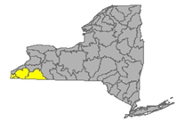
The Allegheny River originates in Pennsylvania, curving north to take a short loop through southwest New York and back down into PA. Tributaries to the Allegheny system include Chadakoin River, Conewango Creek, Cassadaga Creek, Olean Creek, Great Valley Creek, French Creek. Important water bodies include the Allegheny Reservoir and popular recreational destination, Chautauqua Lake.
Flows taking in parts of Chautauqua and Cattaraugus County
- Chadakoin River drains an area of 194 sq miles of Chautauqua County. The flow at Falconer is much above normal, 267.3% above mean at 978 cfs and 2.83 ft deep (flood stage 4ft) (05-03-22)
- Allegheny River drains an area of 1608 sq miles of Cattaraugus County. The flow
- at Olean is unrated, 56.5% above mean at 1900 cfs and 3.55 ft deep (flood stage 12 ft);
- at Salamanca is normal, 70.8% above mean at 2720 cfs and 4.42 ft deep, (flood stage 12 ft) 10°C. (updated 05-03-22)
- Dodge Creek drains an area of 47.7 sq miles in Cattaraugus County. The flow at Portville is unrated, 7.35 ft deep (updated 05-03-22)
Impaired Water Bodies (14)
14 water bodies appear on the 2022 Draft 303(d) list for Allegheny River Watershed, up from 8 in the last list. Of the 14 total, 2 are affected by a proposed delisting in 2022, in whole or in part.
For more details, check out the posted list under the SW tab.
Spills (2)
Cattaraugus County (2):
-Equipment failure in Salamanca caused 10 gallons of hydraulic oil to be spilled in the soil 04/21/22, unresolved
-Unknown cause in Olean caused unknown amounts of 4-dioxane to be spilled in the soil and ground water 04/21/22, unresolved
Chautauqua County (0)
Chemung River Watershed
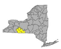
The Chemung River flows across the western portion of the Southern Tier of New York State before joining the Susquehanna River and eventually emptying into the Chesapeake Bay.
Including Chemung River, Cohocton River, Tioga River, Canisteo River; Lamoka Lake/Mill Pond, Waneta Lake, Almond Lake
Flows: washing over parts of Steuben and Chemung Counties
- Chemung River drains an area of 2506 sq miles in Steuben and Chemung Counties. The flow
- at Corning is normal, 77.3% above mean, 2790 cfs and 16.68 ft deep (flood stage is 29ft);
- at Elmira in Chemung County, flow is unrated, 77.2% above mean at 3190 cfs and 2.73 ft deep (flood stage 12 ft);
- at Chemung is normal, 78% above mean at 3770 cfs and 5.27 ft deep. (flood stage 16 ft) (updated 04-23-22)
- Canisteo River drains an area of 40 sq miles of Steuben County. The flow
- at Arkport is normal, 56.7% above mean at 22.4 cfs and .98 ft deep;
- below Canacadea Creek at Hornell in Steuben County is normal, 58.6% above mean at 115 cfs and 1.36 ft deep (flood stage 9ft);
- at West Cameron in Steuben County normal, 43.6% above mean at 199 cfs and 4.19 ft deep (flood stage 17ft). (updated 05-03-22)
- Canacadea Creek drains an area of 57.9 sq miles in Steuben County. The flow near Hornell is normal, 63.4% above historic mean at 49.7 cfs and 1.28 ft deep. (flood stage 5ft) (updated 05-03-22)
- Cohocton River drains an area of 370 sq miles of Steuben County. The flow
- near Avoca is unrated, 55.1% above mean at 151 cfs and 2.86 ft deep (flood stage 9ft);
- at Bath is 3.23 ft deep (flood stage 11ft);
- near Campbell in Steuben County is below normal, 51.2% above mean at 325 cfs and 3.14 ft deep (flood stage 10ft). (updated 05-03-22)
- Tuscarora Creek drains an area of 102 sq miles sq miles in Steuben County before joining the Tioga River, flowing north to the Chemung system. The flow above South Addison is unrated, 39.6% above mean at 40.1 cfs and .55 ft deep. (flood stage 9 ft) (updated 05-03-22)
- Tioga River drains an area of 1377 sq miles in Steuben County. The flow at headwaters in PA,
- at Tioga Junction, PA is normal, 39.6% above mean at 321 cfs and 7.51 ft deep, 13.3ºC and 142 µS/cm;
- at Lindley, NY is below normal, 38.4% above mean at 436 cfs and 4.18 ft deep;
- near Erwins is normal, 41% above mean at 846 cfs and 2 ft deep (flood stage 18ft); (updated 05-03-22)
Impaired Water Bodies (9)
9 water bodies appear on the 2022 Draft 303(d) list for Chemung River Watershed, up from one in the previous list. Of the 9 total, 2 are affected by a proposed delisting in 2022, in whole or in part.
For more details, check out the posted list under the SW tab.
Spills (1)
Chemung County (1):
-Other cause in Van Etten caused unknown amounts of kerosene to be spilled on an unknown resource 04/22/22, resolved 04/26/22
Steuben County (0)
Susquehanna River Watershed
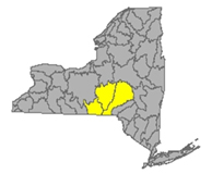
The Susquehanna River drains 27,500 square miles covering large parts of New York, Pennsylvania and Maryland before emptying into the Chesapeake Bay. The flow begins in south New York State and flows in a westerly direction close to the south state line before departing into PA.
Including: Chenango River, Tioughnioga River, Unadilla River, Owego Creek; Otsego Lake, Canadarago Lake, Whitney Point Lake/Reservoir
Flows parts of Otsego, Broome, Chenango and Cortland Counties
- Susquehanna River drains an area of 4773 sq miles of Otsego and Broome Counties, flows from its headwaters at Otsego Lake in a south-westerly direction, crossing the border into Pennsylvania near Waverly NY. The flow
- at Unadilla is normal, 85.2% above mean at 2030 cfs and 4.77 (flood stage 11 ft) ft deep;
- at Bainbridge is unrated, 68.3% above mean at 2810 cfs and 4.5 ft deep (flood stage 15 ft);
- at Windsor, unrated, 75.7% above mean at 3660 cfs and 5.99 ft deep (flood stage 17ft);
- at Conklin flow is normal, 81.75% above mean at 4000 cfs and 4.97 ft deep (flood stage 12 ft);
- at Binghamton, the flow is not rated, 3.91 ft deep, (flood stage 14 ft);
- at Vestal in Broome County is normal, 89.1% above mean at 8030 cfs and 6.71 ft deep (flood stage 18 ft);
- at Owego is unrated, 71.7% above mean is 7620 cfs and 15.79 ft deep (flood stage 30 ft);
- at Waverly flow is normal, 76.35% above mean at 7960 cfs and 3.88 ft deep (flood stage 13 ft). (updated 05-03-22)
- Owego Creek drains an area of 185 sq miles in Tioga County. The flow near Owego is unrated, 32.8% above mean, 197 cfs and 1.43 ft deep (flood stage 9ft) (updated 05-03-22)
- Chenango River drains an area of 1483 sq miles in Broome and Chenango Counties. The flow
- at Sherburne is above normal, 126% above mean at 673 cfs and 3.13 ft deep (flood stage 8.5 ft);
- at Oxford in Chenango is unrated, 85.7% above mean at 788 cfs and 9.4 ft deep;
- at Greene in Chenango County flow is normal, 84.9% above mean at 1010 cfs and 4.29 ft deep;
- at Chenango Forks in Broome County is normal, 82% above mean at 2520 cfs and 4.33 ft deep (flood stage 10ft). (updated 05-03-22)
- Tioughnioga River drains an area of 292 sq miles in Cortland County. The flow
- at Cortland is normal, 88.2% above mean at 570 cfs and 4.02 ft deep,
- at Itaska the flow is not rated, 2.87 ft deep (flood stage 7 ft). (updated 05-03-22)
- Otselic River drains an area of 147 sq miles in Cortland County. The flow at Cincinnatus is normal, 72.4% above mean at 237 cfs and 1.76 ft deep (flood stage 9 ft) (updated 05-03-22)
- Unadilla River drains an area of 520 sq miles of Chenango County. The flow at Rockdale is normal, 79.5% above mean at 897 cfs and 5.32 ft deep (flood stage 11 ft). (updated 05-03-22)
- Ouleout Creek drains an area of 103 sq miles in Delaware County. The flow at East Sydney is normal, 47.1% above mean at 88.7 cfs and 1.54 ft deep (flood stage 4.5 ft) (updated 05-03-22)
Impaired Water Bodies (18)
18 water bodies appear on the 2022 Draft 303(d) list for Susquehanna River Watershed, up from three in the last listing. For more details, check out the posted list under the SW tab.
Spills (9)
Broome County (3):
-Storm in Vestal caused 5 gallons of transformer oil to be spilled in the soil 04/20/22, unresolved
-Storm in Whitney Point caused 1 gallon of transformer oil to be spilled in the soil 04/20/22, unresolved
-Storm in Chenango Forks caused unknown amounts of transformer oil to be spilled in the soil 04/21/22, unresolved
Chenango County (3):
-Other cause in Plymouth caused unknown amounts of waste oil to be spilled on an unknown resource 04/22/22, unresolved
-Storm in Guilford caused 5 gallons of transformer oil to be spilled in the soil 04/24/22, resolved 04/25/22
-Unknown cause in Norwich caused unknown amounts of #2 fuel oil to be spilled on an unknown resource 04/26/22, unresolved
Cortland County (1):
-Storm in Marathon caused 3 gallons of transformer oil to be spilled in the soil 04/24/22, unresolved
Otsego County (2):
-Equipment failure in Oneonta caused unknown amounts of transformer oil to be spilled in the soil 04/22/22, unresolved
-Other cause in Maryland caused 0.5 gallons of transformer oil to be spilled in the soil 04/22/22, unresolved
Report Key:
Flows: USGS Monitoring stations vary in the amount of data collected, certain stations report flow depth and flood stage only, the majority of stations included in this report show the variability of the flow, with a rating of low, normal, above normal, much above normal or high.
Water quality parameters are detected at certain sites, including temperature (°C) and specific conductance (µS/cm). Specific conductance is an important measurement of water quality. This is a measure of the way that electrical current moves through the water; any change in this number is an early warning of changing contaminant loads. The measurement taken by USGS is temperature adjusted to 25°C, allowing for comparison of the specific value from week to week.
National Weather Service: high water terminology here https://www.weather.gov/aprfc/terminology
Impaired Water Bodies (these are lakes, reservoirs, rivers, or parts of rivers with water quality tests indicating the system is impaired; these are listed in the New York State 2018 Final Section 303 (d) list, along with the contaminant of concern and suspected source of contamination. The NYS DEC recommends the water body for a Total Maximum Daily Load (TMDL) watershed protection plan.
Spills Report– hazardous materials spill incidents by county, as appearing in the NYS Environmental Sites - Spill Incidents Database, from week to week as records are uploaded.
See Watershed Basics Glossary for more details.