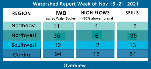
Central NY Watersheds emptying into Atlantic Ocean at Long Island Sound
Upper Hudson River Watershed –
The Upper Hudson River Watershed drains the south side of the Adirondack Mountains, originating on Mt. Marcy and flowing south; the watershed management area extends to the Albany-Rensselaer County line. From the confluence of the Mohawk River, the Lower Hudson River gathers volume and carries on south to the Atlantic via Long Island Sound tidal estuary.
Including Sacandaga River, Schroon River, Indian River, Fish Creek, Hoosic River, Batten Kill, Great Sacandaga Lake, Indian Lake, Schroon Lake, Saratoga Lake
Flows – 3 systems reporting above 90th percentile (flows above 90th percentile are shown in boldface, flows in action stage or flood stage appear in red)
- Hudson River at Newcomb is flowing much above normal, 304% above mean at 1260 cfs; at North Creek is 243% above mean at 3700 cfs; above Hadley is flowing much above normal, 281% above normal at 7410 cfs; Hudson River above Lock 1 near Waterford is flowing much above normal, 206% above normal at 16100 cfs;
- Batten Kill below Mill at Battenville is flowing much above normal, 261% above mean at 1650 cfs
- Hoosic River below Eagle Bridge is flowing much above normal, 238% above mean, 2190 cfs
- Schroon River drains an area of 527 sq miles in Warren County;
Upper Hudson River – Black River Regulating District operates the largest reservoir in the state, the Conklingville Dam, 37.7 billion cubic ft of storage from which flows 40% of the Hudson River volume.
Impaired Water Bodies (3 recommended for total maximum daily load TDML plan)
These are lakes, reservoirs, rivers or parts of rivers where water quality tests indicate the system is impaired, with excess nutrients or contaminants; the water body is placed on New York State 2018 Final Section 303 (d) list, along with the contaminant of concern and suspected source of contamination. The NYS DEC recommends the water body for a Total Maximum Daily Load (TMDL) watershed protection plan.
- Dwaas Kill and tributaries
- Ballston Lake
- Tributaries to Lake Lonely
When the impaired water body is also a drinking water source, see below.
Drinking Water Source Protection Program (DWSP2) –
According to NYS DEC advice, an overlay district is a special zoning area placed over the “base” zoning district(s) for the purpose of protecting a resource such as a waterbody or historic area, addressing a special problem, or to guide development within a special area.
In the case of waterbodies, an overlay district may be established to protect streams, wellheads, establish buffer areas, restrict activities within buffers, and more. The overlay zone is protecting water quality by setting additional standards for development and incorporating site-specific review procedures. Overlay districts, like other comprehensive zoning tools, aid with controlling or limiting non-point source pollution and future development.
The Drinking Water Source Protection Plan should contain the overlay zone boundaries, defined standards, stakeholder engagement and review procedures. Funding may be available, consult NYS Department of Environmental Conservation.
Drinking Water Sources:
Saratoga County: Saratoga County Water Authority (SCWA) draws and treats water from the Upper Hudson River for delivery to residents of Moreau, Wilton, Ballston Spa, Clifton Park Water Authority, Halfmoon, Malta, Stillwater Town and Village, Luther Forest Tech Campus. The treatment plant uses a coagulant, membrane filtration and active carbon filtration, followed by pH adjustment with soda and an anti-corrosive. As of 2020 annual report, the water supply was clear of the common contaminants. Check the Annual Water Quality Report at SCWA on line. Mechanicville draws drinking water from the Mechanicville Reservoir; Saratoga Springs draws from Loughberry Lake.
Great Sacandaga Lake Reservoir in Fulton and Saratoga Counties, Adirondack Park is managed by the Upper Hudson River – Black River Regulating District. A series of dams in the system is set to release an increasing volume of water each day for the week of Nov 15-21; averaging 2000 cfs Monday to 3800 cfs by Sunday from Great Sacandaga Lake, Indian Lake and Stillwater Reservoirs are set to release a steady rate of 407 cfs and 600 cfs daily, respectively. Sixth Lake and Old Forge Reservoirs are set to release slightly less by the end of the week, dropping from 74 to 72 cfs and 176 to 171 cfs respectively. (From Gauge Data and Release Plans, Upper Hudson – Black River Regulating District.)
- Water Quality at USGS #01318500 Lat 43°19'08", long 73°50'39" Saratoga County, NY, Hydrologic Unit 02020001, on right bank at Hadley, 400 ft downstream from outlet of Lake Luzerne, and 0.3 mi upstream from Sacandaga River: remarks: Some diurnal fluctuation caused by powerplant on Schroon River. Flow regulated by Indian Lake (station 01314500), Lake Abanakee and other reservoirs upstream from station.
Washington County: Fort Edward draws water from four reservoirs, according to Hudson Riverkeepers.
Warren County: Queensbury, Glens Falls draw from Upper Hudson River.
Rensselaer County: The Tomhannock Reservoir near Troy is the drinking water source for several communities, including Troy, Brunswick, East Greenbush, North Greenbush, Poestenkill and Schaghticoke, Waterford, Schuylerville, Victory, Menands and Renssselaer. As of May 2021, two cast iron main lines installed in 1914 are being replaced from the Tomhannock Reservoir to the water treatment plant. The four miles of pipe for this project is estimated to take another year to year and a half to complete.
Spill Report
Saratoga County:
-Equipment failure in Waterford caused unknown amounts of hydraulic oil to be spilled in the soil 11/10/21, resolved 11/10/21
-Equipment failure in West Milton caused 1 gallon of hydraulic oil to be spilled in the soil 11/10/21, resolved 11/10/21
-Equipment failure in Charlton caused 1 gallon of transformer oil to be spilled in the soil 11/10/21, unresolved
-Equipment failure in Malta caused 3 gallons of hydraulic oil to be spilled in the soil 11/10/21, resolved 11/10/21
Washington County: None reported
Warren County:
-Equipment failure in Glens Falls caused 5 gallons of unknown material to be spilled on an unknown resource 11/10/21, unresolved
-Equipment failure in Bolton Landing caused unknown amounts of diesel to be spilled on an unknown resource 11/10/21, unresolved
Hamilton County: None reported
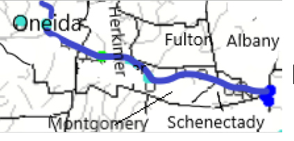
Mohawk River Watershed
The Mohawk River originates in the western Adirondacks and the Tug Hill Plateau and flows 140 miles to the east where it joins the Hudson River. Sections of the Mohawk River also serve as the New York State Barge (Erie) Canal.
Including Schoharie Creek, West Canada Creek, East Canada Creek; Hinkley Reservoir, Delta Reservoir, Peck Lake, Schoharie Reservoir; joins the Hudson River below Albany.
Flows: 3 systems are reporting above 90th percentile
- Mohawk River drains an area of 3450 sq miles in Oneida, Herkimer, Montgomery, Schenectady and Albany Counties. The flow at Delta Dam near Rome is flowing much above normal, 224% above mean at 909 cfs; near Utica in Herkimer County is flowing much above normal, 205% above mean flow at 2740 cfs; at Fonda is flowing 175% above mean at 8090 cfs; at Amsterdam is flowing 189% above mean at 11100 cfs, and 3.47 ft deep; at Freeman’s Bridge in Schenectady County is flowing 212% above mean at 11600 cfs and 11.31 ft deep; at Cohoes in Albany County is flowing 252% above mean at 14300 cfs as it joins the Hudson River.
Mohawk River
- West Canada Creek at Cast Bridge in Herkimer County is flowing normal, 91% above mean at 1380 cfs;
- East Canada Creek at East Creek in Herkimer, flowing above normal, 200% above mean flow 1460 cfs
- Schoharie Creek drains an area of 886 sq miles of Schoharie County; at North Blenheim is flowing much above normal, 385% above mean at 1050 cfs; at Breakabeen is flowing much above normal, 336% above mean and 1370 cfs; at Burtonsville in Schoharie County is flowing much above normal at 343% above mean, 2500 cfs
- Platter Kill at Gilboa is flowing much above normal at 247% above mean flow, 23.7 cfs
Impaired Water Bodies (9 recommended for TDML plan)
These are lakes, reservoirs, rivers or parts of rivers where water quality tests indicate the system is impaired; the water body is placed on New York State 2018 Final Section 303 (d) list, along with the contaminant of concern and suspected source of contamination. The NYS DEC recommends the water body for a Total Maximum Daily Load (TMDL) watershed protection plan.
- Mohawk River main stem, portion 12 and 13 (Herkimer, Oneida)
- Utica Harbor (Oneida)
- Ann Lee (Shakers) Pond, Stump Pond
- Collins Lake
- Mariaville Lake
- Schoharie Reservoir
- Cobleskill Creek and lower tributaries
- Steel Creek
- Ballou, Nail Creeks
Drinking Water Source Profile: Hinckley Reservoir (01343900)– (from USGS Water Quality Watch)
Located on West Canada Creek in Herkimer County, Hinckley Reservoir collects streamflow from an undeveloped natural area of 374 square miles in the Adirondack Mountains,
And supplies drinking water for the City of Utica. The earth and concrete dam began storing water in 1914, with diversion for the city of Utica beginning several years later. Drinking water treatment and distribution is provided by Mohawk Valley Water Authority, serving 126,250 customers through 650 miles of pipe to 38,900 service connections. The water treatment plant at Prospect (1992) double filters to remove organic matter and chlorinates the water to kill bacteria. Fluoride is added, along with lime and soda ash to render the water non-corrosive to pipes and plumbing. Water quality is monitored by the MVWA certified laboratory staff. The Annual Water Quality Report 2020 is available here https://www.mvwa.us/WaterQuality/2020AWQR.pdf
Hinckley Reservoir was selected for intensive (monthly) sampling through the NYSDEC Division of Water’s Lake Classification and Inventory (LCI) program in the summer of 2011. The lake was classified as mesotrophic, or moderately productive. (Lake Classification and Inventory Survey, Lake Water Summary, Newman et al, NYS DEC 2011)
More information about contaminants and potential health effects can be obtained by calling the EPA’s Safe Drinking Water Hotline at
800-426-4791 or the Oneida County Health Department at 315-798-5064.
Spill Report
Montgomery County: None reported
Schoharie County: None reported
Herkimer County: None reported
Greene County:
-Unknown cause in Coxsackie caused 0.25 gallons of diesel to be spilled in the soil 11/10/21, unresolved
Schenectady County:
-Equipment failure in Schenectady caused 5 gallons of hydraulic oil to be spilled on an unknown resource 11/09/21, resolved 11/10/21
-Equipment failure in Schenectady caused unknown amounts of hydraulic oil to be spilled on an unknown resource 11/10/21, unresolved
Fulton County: None reported
Lower Hudson River Watershed –
The Lower Hudson Watershed begins where the Mohawk River joins the Hudson system at the Troy Dam and extends down to Manhattan. The lower end of the Hudson system, 153 miles, is technically a tidal estuary, not a river.
Rondout/Wallkill Rivers, Stockport/Kinderhook Creeks, Catskill Creek, Esopus Creek, Croton River; Ashokan Reservoir, Rondout Reservoir, New Croton Reservoir, Alcove Reservoir, Cross River Reservoir, Muscoot/Upper New Croton Reservoir
Flows: 2 systems reporting flows above 90th percentile
- Hudson River at Green Island is flowing above normal, 213% above mean to 26,900 cfs
- Esopus Creek drains an area of 419 sq miles of Ulster County; below Lost Clove Rd at Big Indian the flow is above normal, 211% over mean at 93 cfs; at Allaben is 255% above mean at 358 cfs;
at Mount Marion is much above normal, 388% above mean at 1720 cfs and 16.27 ft deep
- Valatie Kill drains an area of 9.8 sq miles of Rensselaer County before joining the Hudson; the flow near Nassau is above normal 179% above mean at 21.9 cfs
- Kinderhook Creek drains an area of 329 sq miles in Columbia County before joining the Hudson River. The flow at Rossman is much above normal, 320% above mean at 1110 cfs
- Wappinger Creek drains an area of 181 sq miles of Dutchess County; the flow at Wappinger Falls is above normal, 164% above mean at 325 cfs.
- Rondout Creek drains an area of 383 sq miles in Ulster County; the flow at Lowe’s Corners is above normal, 183% above mean, 928 cfs and 10.5 ft deep
Impaired Water Bodies (25 listed for Total Maximum Daily Load plan, as of June 2020)
- Sawmill River, Lake Shenorock, Lake Lincolndale, Lake Katonah, Truesdale Lake, Teatown Lake, Lake Meahagh, Wallace Pond, Lake Mohegan in Westchester County
- Hillside Lake, Wappingers Lake, Falkill Creek in Dutchess County
- Krumkill Creek, Patroon Creek, Minor tributaries west of Hudson River in Albany County
- Sparkill Creek in Rockland County
- Lost Lake, Putnam Lake in Putnam County
- Monhagen Brook in Orange County
- Ashokan Reservoir and Esopus Creek in Ulster County
- Robinson Pond in Columbia County
- Sleepy Hollow Lake in Greene County
- Duane Lake in Schenectady County
- Nassau Lake and Snyders Lake in Rensselaer County
Public Drinking Water Systems – Surface Water Sources
Poughkeepsie Town wide Water District serves 43000 in Dutchess County, Highland Water District, serving 4000 in Ulster County, Kingston Water District, Ulster County, United Wappinger Water Improvement District, serving 14000 in Dutchess County. Beacon City PWS serves 19000 in Dutchess County, Newburgh City serves 28000 in Orange County, Cornwall on Hudson serves 23000 in Orange County.
New Windsor Consolidated Water District serves 30000 in Orange County
According to the latest annual water quality report, 2019, source includes surface water drawn from the Ashokan Reservoir via the Catskill Aqueduct. The water is treated with chemicals and filtered, with chlorine added to sanitize and pH balancers (caustic soda) added to prevent corrosion of pipes. Annual water quality reports can be found online at water.ny.gov, searchable by location, PWS (public water supply) number, or county.
Spill Report
Westchester County:
-Equipment failure in Yonkers caused unknown amounts of gasoline to be spilled on an unknown resource 11/07/21, unresolved
-Equipment failure in Ardsley caused 2 gallons of dielectric fluid to be spilled in the soil 11/08/21, resolved 11/08/21
-Equipment failure in Pleasantville caused unknown amounts of #2 fuel oil to be spilled in the soil 11/08/21, unresolved
-Equipment failure in Tarrytown caused 150 gallons of #2 fuel oil to be spilled in the soil 11/09/21, unresolved
Orange County:
-Equipment failure in highland caused unknown amounts of #2 fuel oil to be spilled in the soil 11/07/21, resolved 11/08/21
-Equipment failure in Montgomery caused 30 gallons of other material to be spilled on an unknown resource 11/10/21, resolved 11/10/21
-Equipment failure in Wallkill caused unknown amounts of #2 fuel oil to be spilled in the soil 11/10/21, unresolved
-Equipment failure in New Windsor caused 300 gallons of diesel to be spilled in surface water 11/10/21, resolved 11/10/21
-Unknown cause in Otisville caused unknown amounts of gasoline to be spilled on an unknown resource 11/10/21, unresolved
-Equipment failure in Newburgh caused 30 gallons of #2 fuel oil to be spilled on an unknown resource 11/12/21, unresolved
Putnam County: None reported
Columbia County:
-Equipment failure in Hudson caused 2 gallons of hydraulic oil to be spilled in the soil 11/08/21, unresolved
-Equipment failure in Hudson caused 0.5 gallons of hydraulic oil to be spilled in the soil 11/10/21, unresolved
Rensselaer County:
-Equipment failure in North Greenbush caused 30 gallons of antifreeze to be spilled on an unknown resource 11/09/21, unresolved
-Storm in Troy caused 20 gallons of transformer oil to be spilled in the soil 11/12/21, unresolved
-Unknown cause in Nassau caused unknown amounts of gasoline to be spilled on an unknown resource 11/13/21, unresolved
Delaware River Watershed
The headwaters flow down from the Catskill Mountains into Delaware Bay/Atlantic Ocean. The watershed area includes East Branch Delaware River, West Branch Delaware River, Neversink River, Mongaup River, Pepacton Reservoir, Cannonsville Reservoir and Neversink Reservoir.
Flows: 4 systems have flow over 90th percentile this week
- East Branch Delaware River drains an area of 458 sq miles in Delaware County. The flow at Roxbury is above normal, 157% above mean at 33.9 cfs, at Margaretville 228% above mean at 660cfs; at Downsville in Delaware County is flowing much above normal, 386% above mean, 697 cfs and 3.84 ft deep; at Harvard 317% above mean, 1160 cfs and 4.64 ft deep
- West Branch Delaware River drains an area of 595 sq miles of Delaware County. The flow at Stilesville in Delaware County is much above normal at 444% above mean at 1460 cfs and 8.83 ft deep; at Walton in Delaware County is 258% above mean at 480 cfs and 6 ft deep; at Hale Eddy in Delaware County is flowing much above normal, 340% above mean flow at 2170 cfs and 5 ft deep
- Tremper Kill drains an area of 33 sq miles of Delaware County; the flow is 217% above normal at 129 cfs and 3.25 ft deep
- Neversink River at Neversink is flowing much above normal, 371% above mean at 166 cfs and 3.6 ft deep.
- Delaware River drains an area of 1820 sq miles of Delaware County. The flow at Callicoon is much above normal, 239% above meat at 6260 cfs and 5 ft deep, near Barryville is 242% above mean at 6760 cfs and 5.9 ft deep
Impaired Water Bodies (6 recommended for Total Maximum Daily Load plan development, as of June 2020)
Sullivan County
- Davies Lake, Pleasure Lake, Evens Lake, Swan Lake, Bodine/Montgomery Lake
Broome County
Spill Report:
Sullivan County:
-Equipment failure in Ferndale caused unknown amounts of diesel to be spilled on an unknown resource 11/11/21, unresolved
-Traffic accident in Woodbourne caused 3 gallons of transformer oil to be spilled on an unknown resource 11/11/21, unresolved
-Unknown cause in Harleysville caused unknown amounts of unknown petroleum to be spilled in the soil 11/13/21, unresolved
Delaware County:
-Equipment failure in Arkville caused unknown amounts of diesel to be spilled on an unknown resource 11/09/21, unresolved
Ulster County:
-Equipment failure in lake Katrine caused 5 gallons of hydraulic oil to be spilled on an unknown resource 11/08/21, unresolved
-Equipment failure in Olive Bridge caused 0.25 gallons of hydraulic oil to be spilled in the soil 11/09/21, unresolved
-Equipment failure in Clintondale caused unknown amounts of other material to be spilled in the soil 11/09/21, resolved 11/09/21
Housatonic River Watershed
A small portion of the headwaters of the Housatonic lie in eastern New York State. These waters drain the Taconic and Berkshire Mountains before joining the Housatonic and eventually emptying into Long Island Sound. Includes Tenmile River, Green River, Indian Lake, Swift/Crane Ponds
High Flow:
Housatonic and Green Rivers are flowing at normal range, as noted in monitoring stations at Great Barrington, Vermont.
Impaired Water Bodies
Spill Report:
Dutchess County:
-Unknown cause in Union Vale caused unknown amounts of #2 fuel oil to be spilled on an unknown resource 11/09/21, resolved 11/09/21
-Unknown cause in Union Vale caused unknown amounts of #2 fuel oil to be spilled on an unknown resource 11/09/21, resolved 11/09/21
-Equipment failure in Pine Plains caused 5 gallons of hydraulic oil to be spilled on an unknown resource 11/10/21, unresolved
-Unknown cause in Red Hook caused unknown amounts of auto waste fluids to be spilled on an unknown resource 11/12/21, resolved 11/12/21
Ramapo River Watershed –
The northern headwaters of the Passaic basin lie within a small portion of southeastern New York State, including the Ramapo and Hackensack Rivers drainage areas. It is the smallest watershed in New York State. Including Ramapo River, Hackensack River, Greenwood Lake, DeForest Lake.
High Flow: all systems below 90th percentile this week
- Ramapo River drains an area of 93 sq miles in Rockland County. The flow at Suffern is normal this week, 92% above mean at 181 cfs and 3.3 ft deep.
Impaired Water Bodies (2 recommended for TDML plan)
Rockland County
- Rockland Lake
- Congers Lake/Swartout Lake
Spills Report:
Rockland County:
-Equipment failure in Nanuet caused unknown amounts of transformer oil to be spilled on an unknown resource 11/08/21, resolved 11/08/21
-Equipment failure in Pomona caused 2lbs of diesel to be spilled on an unknown resource 11/09/21, unresolved
-Equipment failure in Pomona caused unknown amounts of #2 fuel oil to be spilled on an unknown resource 11/09/21, unresolved
Atlantic Ocean/Long Island Sound Watershed
The Atlantic Ocean/Long Island Sound Watershed drains most of the New York City Metropolitan Area and all of Long Island. The drainage area includes all marine waters in New York Harbor, Long Island Sound, Block Island Sound, and along the South Shore of Long Island, and the fresh waters that drain into them.
Includes 1415 square miles of marine estuary waters, the Bronx River, Mamaroneck River, Mianus River, Peconic River, Kensico Reservoir, Lake Ronkonkoma.
High Flow:
- Sampawams Creek drains an area of 23 sq miles in Suffolk County. The flow at Babylon is much above normal, 194% above mean at 17.1 cfs and less than 1 ft deep.
Impaired Water Bodies (49 recommended for TDML plans)
Richmond County
- Arthur Kill (oxygen demand)
- Grasmere Lake/Brady’s Pond (phosphorous)
New York County
- The Lake in Central Park (phosphorous)
- Harlem Meer (phosphorous)
Bronx County
- Van Cortlandt Lake (phosphorous)
- Reservoir #1/ Lake Isle (phosphorous)
Westchester County
- Bronx River, Upper and tributaries (oxygen demand, fecal coliform)
- Larchmont Harbour (fecal coliform)
- Hutchison River, upper and tributaries (oil and grease, oxygen demand, fecal coliform)
- Mamaroneck Harbour (fecal coliform)
- Mamaroneck River, lower, Upper, tributaries (oxygen demand, silt/sediment)
- Sheldrake River (phosphorous, silt/sediment)
- Silver Lake (phosphorous)
- Milton Harbor/Lower Blind Brook (fecal coliform)
- Port Chester Harbor/Lower Byram River (fecal coliform)
Nassau County
- Manhasset Bay and tidal tributaries (fecal coliform)
- Hempstead Harbour (fecal coliform)
- Beaver Lake (phosphorous)
- Massapequa Cove, Upper Creek and Tributaries (fecal coliform, phosphorous)
- Seaford, Seamans Creeks, tidal tributaries (fecal coliform)
- Tributaries to East Bay (freshwater silt/sediment and phosphorous)
- Camaans Pond (phosphorous)
- East Meadow Brook upper and tributaries (silt/sediment)
- Milburn/Parsonage Creek and tributaries (phosphorous)
- Hempstead Bay and tributaries /Broad Channel (phosphorous, nitrogen)
- Hewlett Bay (nitrogen)
- Browserer Bay (nitrogen)
- Hog Island Channel (nitrogen)
- East Rockaway Channel (nitrogen)
- Hempstead Lake (phosphorous)
- Grant Park Pond (phosphorous)
- Woodmere Channel (nitrogen)
- Bannister Creek/Bay (nitrogen)
- Prospect Park Lake (phosphorous)
Queens County
- Meadow Lake (phosphorous)
- Willow Lake (phosphorous)
- Kissena Lake (phosphorous)
- Little Neck Bay (fecal coliform)
Suffolk County
- Millers Pond (phosphorous, low oxygen)
- Long Island Sound (fecal coliform)
- Mattituck/ Marratooka Pond (phosphorous, low oxygen)
- Agawam Lake (Phosphorous, low oxygen)
- Shinnecock Bay (Nitrogen)
- Quantuck Bay (Nitrogen, low oxygen)
- Moriches Bay, East and West, tidal tributaries (Nitrogen, low oxygen, fecal coliforms in west tributaries)
- Great South Bay, East, Middle and West (low oxygen, nitrogen)
- Canaan Lake (phosphorous, silt/sediment)
- Lake Ronkonkoma (fecal coliform, phosphorous)
- Champlin Creek, upper and tributaries (thermal changes)
Spill Report:
Kings (Brooklyn):
-Equipment failure in Brooklyn caused unknown amounts of #2 fuel oil to be spilled in the soil 11/10/21, unresolved
-Equipment failure in Brooklyn caused 3 gallons of dielectric fluid to be spilled in the soil 11/11/21, unresolved
-Equipment failure in Brooklyn caused 10 gallons of hydraulic oil to be spilled on an unknown resource 11/13/21, unresolved
-Equipment failure in Brooklyn caused 50 gallons of dielectric fluid to be spilled on an unknown resource 11/13/21, unresolved
Queens County:
-House keeping in Queens caused unknown amounts of motor oil to be spilled in the soil 11/08/21, unresolved
-Unknown cause in Ridgewood caused unknown amounts of gasoline to be spilled into the air 11/08/21, resolved 11/09/21
-Equipment failure in Queens caused 1 gallon of hydraulic oil to be spilled in the soil 11/09/21, unresolved
Nassau County:
-Equipment failure in Port Washington caused unknown amounts of #2 fuel oil to be spilled in the soil 11/08/21, unresolved
-Equipment failure in Valley Stream caused 1 gallon of transformer oil to be spilled in the soil 11/08/21, unresolved
-Equipment failure in Hicksville caused 2 gallons of #2 fuel oil to be spilled on an unknown resource 11/09/21, unresolved
-Equipment failure in Bellmore caused 2 gallons of #2 fuel oil to be spilled on an unknown resource 11/10/21, unresolved
-Deliberate cause in Elmont caused unknown amounts of other material to be spilled on an unknown resource 11/10/21, resolved 11/12/21
Suffolk County:
-Equipment failure in West Islip caused 3 gallons of transformer oil to be spilled on an impervious surface 11/07/21, unresolved
-Equipment failure in East Patchogue caused 10 gallons of #2 fuel oil to be spilled on an impervious surface 11/07/21, unresolved
-Unknown cause in Greenport caused unknown amounts of gasoline to be spilled on an unknown resource 11/08/21, unresolved
-Unknown cause in Holtsville caused unknown amounts of unknown petroleum to be spilled into the sewer and impervious surface 11/08/21,unresolved
-Equipment failure in Amityville caused unknown amounts of #2 fuel oil to be spilled in the soil 11/08/21, unresolved
-Equipment failure in Holbrook caused 50 gallons of hydraulic oil to be spilled on an impervious surface 11/08/21, resolved 11/16/21
Richmond County:
-Equipment failure in Staten Island caused unknown amounts of transformer oil to be spilled on an unknown resource 11/10/21, unresolved
-Traffic accident in Staten Island caused unknown amounts of gasoline to be spilled on an unknown resource 11/13/21, resolved 11/15/21
-Storm in Staten Island caused 10 gallons of transformer oil to be spilled in the soil 11/13/21, unresolved
Bronx County:
-Equipment failure in Bronx caused 50 gallons of #2 fuel oil to be spilled on an unknown resource 11/09/21, resolved 11/09/21
-Equipment failure in the Bronx caused unknown amounts of hydraulic oil to be spilled in the soil 11/10/21, unresolved
Northeast Watersheds– emptying into Atlantic Ocean via St. Lawrence River
Lake Champlain Watershed
The Lake Champlain Watershed drains the area between the Adirondack Mountains in northeastern New York State and the Green Mountains in northwestern Vermont.
Includes the Ausable River, Saranac River, Great Chazy River, Boquet River, Mettawee River, Ticonderoga Creek/Lake George, Lake George,
Upper Saranac Lake, Lower Saranac Lake, Lake Placid, Lake Champlain
High Flows: all flows in normal range
Impaired Water Bodies (6 recommended for TDML plan)
Clinton County –
- Great Chazy River, lower main stem (silt/sediment from agriculture and erosion)
Warren County-
- Lake George and its tributaries, including east tributaries and lake village (silt/sediment from urban stormwater drainage and erosion)
- Huddle/Finkel Brook and tributaries (silt/sediment from urban stormwater drainage and erosion)
- Indian Brook and tributaries (silt/sediment from urban stormwater drainage and erosion)
- Hague Brook and tributaries (silt/sediment from urban stormwater drainage and erosion)
Washington County-
- Wood Creek/Champlain Canal and tributaries (phosphates, low oxygen, fecal coliforms)
Spill Report:
Clinton County:
-Equipment failure in Champlain caused 2 gallons of ethylene glycol to be spilled on an unknown resource 11/10/21, unresolved
-Traffic accident in Keysville caused 10 gallons of transformer oil to be spilled in the soil 11/10/21, unresolved
Essex County: None reported
St. Lawrence River Watershed
185 km of the St. Lawrence River catches the runoff from the northern and western Adirondack Mountains, drawing from portions of eight states, a combined area of 5600 square miles.
St. Lawrence Watershed collects the flow from eleven thousand miles of freshwater rivers and streams, including the Oswegatchie River, Raquette River, Saint Regis River, Grass River and Indian River; including Black Lake, Cranberry Lake, Raquette Lake, Tupper Lake and Long Lake. Densely forested woodlands, peatlands and areas of flat agricultural plains make up the natural surface water filtration system of this watershed area.
High Flows: all flows in normal range
Impaired Water Bodies (4 recommended for TDML plan)
St. Lawrence County
- Raquette River lower and minor tributaries (fecal coliform from onsite WTS)
- Black Lake Outlet, Black Lake (phosphorous, agriculture)
- Fish Creek and minor tributaries (phosphorous from OWTS, sanitary discharge)
- Little River and tributaries (priority organics from industrial site and landfill)
Spill Report
Franklin County: None reported
St. Lawrence County:
-Traffic accident in Colton caused unknown amounts of gasoline and diesel to be spilled on an unknown resource 11/11/21, resolved 11/12/21
-Storm in Star Lake caused 15 gallons of transformer oil to be spilled in the soil 11/12/21, unresolved
Black River Watershed
Filters and drains most of Jefferson and Lewis Counties along with parts of Herkimer, Hamilton and Oneida Counties.
Major tributaries in the system include Moose River, Beaver River, Independence River and Deer River, Stillwater Reservoir, Fulton Chain of Lakes, Lake Lila and Big Moose Lake.
High Flows:
- Beaver River drains 291 sq miles in Lewis County. The flow at Croghan is much above normal, 158% above mean, 971 cfs and 3.5 ft deep.
Impaired Water Bodies (1 recommended for TDML plan)
Lewis County
- Mill Creek south branch and tributaries (nutrients and fecal coliform from agriculture)
Spill Report :
Jefferson County:
-Unknown cause in Worth caused unknown amounts of unknown material to be spilled in the surface water 11/07/21, resolved 11/08/21
Lewis County: None reported
Northwest Watersheds – empty into Atlantic Ocean via Great Lakes and St. Lawrence River
Lake Ontario and Minor Tributaries
This watershed includes the areas between the larger rivers (including Genesee, Oswego and Black Rivers) that empty into Lake Ontario. It is divided into western, central and eastern sections that stretch all along the Lake Ontario Shoreline.
*Includes Salmon River Reservoir, Sodus Bay, North Pond, Irondequoit Bay and Perch Lake; Salmon River, Oak Orchard Creek, Irondequoit Creek, Sandy Creek
High Flows:
- Northrup Creek drains an area of 10.1 sq miles in Monroe County. The flow at North Greece in Monroe County is much above normal, 214% above mean at 34.8 cfs and a foot and a half deep.
Impaired Water Bodies (6 recommended for TMDL plans)
Wayne County
- Lake Ontario Shoreline Central (fecal coliform from urban stormwater runoff)
Monroe County
- Rochester Embayment East and West, (fecal coliform from urban stormwater runoff)
- Buck Pond (phosphorous from urban stormwater/runoff)
- Long Pond (phosphorous from urban stormwater/runoff)
- Cranberry Pond (phosphorous from urban stormwater/runoff)
Orleans County
- Lake Ontario Shoreline, Western (fecal coliform from agriculture source, municipal and other sources)
Spill Report
Orleans County:
-Equipment failure in Holly caused 40 gallons of #2 fuel oil to be spilled into the soil and air 11/07/21, unresolved
Wayne County: None reported
Oswego County:
-Equipment failure in Richland caused 5 gallons of gasoline to be spilled on an unknown resource 11/09/21, resolved 11/09/21
Niagara River/Lake Erie Watershed
The Niagara River drains an area encompassing more than 265,000 square miles in the north central United States and south-central Canada, including Tonawanda Creek, Cattaraugus Creek, Buffalo River, Attica Reservoir and Lime Lake.
High Flows: all flows below 90th percentile this week
Impaired Water Bodies (11 recommended for TDML plan)
Niagara County:
- Gill Creek and tributaries (unknown biological from urban runoff, contaminated sediment)
- Hyde Park Lake (phosphorous from urban stormwater runoff)
- Bergholtz Creek and tributaries (phosphorous and fecal coliform from urban runoff)
Erie County:
- Ransom Creek Upper Lower and tributaries (oxygen demand and fecal coliforms from onsite wastewater treatment system)
- Two Mile Creek and tributaries (oxygen demand and fecal coliform from combined sewer overflow (CSO’s), municipal source)
- Scajaquada Creek, upper, middle and lower (phosphorous, low oxygen, fecal coliform from combined sewer overflows (CSO), urban runoff)
- Delaware Park Pond (phosphorous from urban storm runoff)
- Lake Erie (fecal coliform from urban runoff)
- Rush Creek and tributaries (fecal coliform and phosphorous, from CSOs, urban runoff and municipal sources)
- Green Lake (phosphorous from urban runoff)
Chautauqua County:
- Lake Erie, main lake south, Dunkirk Harbor (fecal coliform from urban storm runoff)
Spill Report
Erie County:
-Equipment failure in Buffalo caused unknown amounts of motor oil to be spilled in the sewer 11/08/21, resolved 11/09/21
-Traffic accident in Brant caused 200 gallons of diesel to be spilled in the soil 11/09/21, unresolved
-Traffic accident in Wales caused unknown amounts of unknown petroleum to be spilled on an unknown resource 11/09/21, resolved 11/10/21
-Other cause in North Collins caused unknown amounts of manure to be spilled in the surface water 11/09/21, resolved 11/09/21
-Human error in Tonawanda caused unknown amounts of transformer oil to be spilled on an unknown resource 11/10/21, resolved 11/10/21
-Equipment failure in Angola caused unknown amounts of other material to be spilled on an unknown resource 11/10/21, unresolved
-Unknown cause in Clarence Center caused unknown amounts of unknown material to be spilled on an unknown resource 11/11/21, resolved 11/12/21
-Tank Test Failure in Cheektowaga caused unknown amounts of gasoline to be spilled on an unknown resource 11/11/21, unresolved
-Storm in Hamburg caused 10 gallons of transformer oil to be spilled in the soil 11/11/21, unresolved
Niagara County:
-Equipment failure in Niagara Falls caused unknown amounts of #2 fuel oil to be spilled in the soil 11/12/21, unresolved
-Equipment failure in Niagara Falls caused 0.5 gallons of transformer oil to be spilled in the soil and sewer 11/12/21, unresolved
-Equipment failure in Middleport caused unknown amounts of motor oil to be spilled on an unknown resource 11/13/21, unresolved
Genesee River Watershed
Including: Conesus Lake, Silver Lake, Mount Morris Reservoir, Hemlock Lake, Honeoye Lake; Cassadaga Creek, Honeoye Creek, Oatka Creek, Black Creek
High Flows: 2 systems reporting over 90th percentile
- Genesee River drains an area of 2474 sq miles in Monroe, Livingston, and Allegany Counties. The flow at Wellsville in Allegany County is normal, 97% above mean at 405 cfs; at Portageville in Wyoming County is above normal 138% above mean at 2020 cfs and 10.6 ft deep; near Mount Morris in Livingston County is above normal, 143% above mean at 2680 cfs and 6 ft deep; at Avon 163% above mean flow, 3090 cfs and 22.8 ft deep; above normal at Ford St Bridge in Rochester, Monroe County, 146% above mean at 3830 cfs and 12.8 ft deep
- Honeoye Creek drains an area of 196 sq miles of Monroe County. The flow at Honeoye Falls in Monroe County is much above normal, 268% above mean at 264 cfs and 3.8 ft deep
- Conesus Creek drains an area of 72 sq miles in Livingston County. The flow is much above normal near Lakeville in Livingston County, 298% above mean at 210 cfs and 2.4 ft deep
- Canaseraga Creek drains an area of 88.9 sq miles of Livingston County. The flow above Dansville is above normal, 112% above mean, at 118 cfs; at Shakers Crossing in Livingston County is flowing above normal as well
Impaired Water Bodies (11 recommended for TDML plan)
Monroe County:
- Black Creek, Lower and minor tributaries (phosphorous from ag and municipal sources)
- Mill Creek Blue Pond Outlet and tributaries (phosphorous from agriculture)
Genessee County:
- Mill Pond (phosphorous from ag)
- Oatka Creek Middle and minor tributaries (phosphorous from agriculture, municipal sources)
- LeRoy Reservoir (phosphorous from agricultural sources)
- Black Creek, Upper and minor tributaries (phosphorous from agriculture and municipal sources)
Ontario County:
- Honeoye Lake (phosphorous and low oxygen demand from agriculture and onsite Waste treatment system)
Livingston County
- Conesus Lake (phosphorous and low oxygen from internal loading)
- Christie Creek and tributaries (phosphorous from agriculture source)
Allegany County:
- Andover Pond (phosphorous from agriculture source)
- Amity Lake/Saunders Pond (phosphorous from unknown source)
Spill Report:
Livingston County:
-Human error in Avon caused 30 gallons of diesel to be spilled in the soil 11/09/21, unresolved
Allegany County:
-Other cause in Cuba caused unknown amounts of gasoline to be spilled in the soil 11/10/21, unresolved
Monroe County:
-Unknown cause in Rochester caused unknown amounts of unknown petroleum to be spilled in the soil 11/08/21, unresolved
-Equipment failure in Scottsville caused 3 gallons of gasoline to be spilled on an unknown resource 11/09/21, unresolved
-Unknown cause in Gates caused unknown amounts of unknown petroleum to be spilled in the soil and ground water 11/09/21, unresolved
-Unknown cause in West Henrietta caused unknown amounts of gasoline to be spilled in the soil 11/09/21, unresolved
Genesee County:
-Other cause in Corfu caused unknown amounts of unknown petroleum to be spilled in the soil 11/08/21, unresolved
Wyoming County: None reported
Oswego River and Finger Lakes Watershed
Including Otisco, Skaneateles, Owasco, Cayuga, Oneida, Seneca, Keuka, Canandaigua, and Canadice Lakes; Oneida River, Clyde River, Cayuga Lake Tributaries and Seneca Lake Tributaries
High Flows: 3 systems flowing above 90th percentile
- Oswego River drains an area of 5100 sq miles of Oswego, Madison, Cayuga, Tompkins, Seneca, Onandaga, Yates and Ontario counties. The flow at Lock 7 in Oswego County is much above normal, 277%, at 18600 cfs and 8.8 ft deep
- Seneca River drains an area of 3130 sq miles of Onandaga County. The flow near Baldwinsville in Onandaga County is much above normal, 294% above mean, at 10600 cfs and 4.9 ft deep
- Canandaigua Outlet drains 195 sq miles of Ontario County. The flow at Chapin in Ontario County has slowed slightly, but still ranked high, 594% above mean at 642 cfs and 5.1 ft deep
- Flint Creek drains an area of 102 sq miles of Ontario County. The flow at Phelps in Ontario County is above normal, 142% above mean flow at 117 cfs and 2.1 ft deep
- Keuka Lake drains an area of 207 sq miles in Yates County. At the outlet near Dresden in Yates County, the flow is above normal, 145% above mean, 291 cfs and 3.6 ft deep
Impaired Water Bodies (7 recommended for TDML plan)
Oswego County:
- Lake Neatahwanta (phosphorous from urban stormwater runoff)
- Pleasant Lake (phosphorous from unknown source
Madison County:
- Canastota Creek, lower and tributaries (fecal coliform, oxygen demand from municipal sources and combined sewer overflows)
Cayuga County:
- Owasco Upper Inlet and tributaries (nutrients from municipal and agricultural source)
- Duck Lake (phosphorous from unknown source)
Tompkins County:
- Cayuga Lake (phosphorous and silt/sediment from agriculture and urban stormwater runoff)
Seneca County:
- Reeder Creek and tributaries (phosphorous from unknown source)
Spill Report:
Seneca County: None reported
Cayuga County:
-Traffic accident in Genoa caused 1000 lbs of milk, and 0.5 gallons of motor oil to be spilled in the soil and surface water 11/07/21, resolved 11/07/21
-Human error in Weedsport caused 11 gallons of diesel to be spilled in the soil 11/08/21, unresolved
Onondaga County:
-Equipment failure in Syracuse caused 1 gallon of antifreeze to be spilled on an impervious surface 11/08/21, resolved 11/08/21
Schuyler County: None reported
Yates County:
-Unknown cause in Starkey caused unknown amounts of other material to be spilled on an unknown resource 11/12/21, unresolved
-Traffic accident in Penn Yan caused unknown amounts of gasoline and motor oil to be spilled in the soil and surface water 11/12/21, unresolved
Ontario County:
-Traffic accident in Farmington caused 250 gallons of diesel to be spilled in the sewer 11/07/21, resolved 11/09/21
Madison: None reported
Tompkins:
-Other cause in Lansing caused 2000 gallons of manure to be spilled on an unknown resource 11/09/21, resolved 11/15/21
-Unknown cause in Ithaca caused 1 gallon of diesel to be spilled on an unknown resource 11/09/21, unresolved
Oneida:
-Unknown cause in Whitesboro caused unknown amounts of other material to be spilled into the air 11/08/21, resolved 11/09/21
-Human error in Whitesboro caused 30 gallons of sodium hydroxide to be spilled on an unknown resource 11/08/21, unresolved
-Other cause in Westmoreland caused unknown amounts of unknown hazardous material to be spilled on surface water 11/09/21, resolved 11/09/21
-Equipment failure in Rome caused unknown amounts of transformer oil to be spilled on an unknown resource 11/09/21, unresolved
-Traffic accident in Vienna caused 8000 gallons of milk to be spilled in the soil 11/11/21, unresolved
-Storm in Marshall caused unknown amounts of manure to be spilled into surface water 11/12/21, unresolved
Southwest Watersheds – Allegheny, emptying into Gulf of Mexico via Ohio River/Mississippi River; Chemung and Susquehanna emptying into Atlantic Ocean via Chesapeake Bay
Allegheny River Watershed (flowing west into Ohio River system)
Including Allegheny River, Chadakoin River, Conewango Creek, Canaseraga Creek, Cassadaga Creek, Olean Creek, Great Valley Creek, French Creek, Allegheny Reservoir, Chautauqua Lake
High Flows: all flows in normal range or below 90th percentile this week
Impaired Water Bodies (8 recommended for TDML)
Cattaraugus County:
- Allegheny River/Reservoir (phosphorous from unknown source)
- Linlyco/Club Pond (phosphorous from unknown source)
- Case Lake (phosphorous from unknown source)
- Beaver Lake/Alma Pond (phosphorous from internal loading)
Chautauqua County:
- Middle Cassadaga Lake (phosphorous from agriculture)
- Chadakoin River and tributaries (phosphorous from urban/industrial runoff)
- Hulburt/Clymer Pond (phosphorous from agriculture)
- Findlay Lake (low oxygen demand from agricultural source)
Spill Report:
Cattaraugus County: None reported
Chautauqua County:
-Equipment failure in Villanova caused 5 gallons of antifreeze to be spilled on an unknown resource 11/08/21, unresolved
-Unknown cause in Westfield caused unknown amounts of unknown petroleum to be spilled in the soil 11/10/21, unresolved
Chemung River Watershed
The Chemung River flows across the western portion of Southern Tier of New York State before joining the Susquehanna River and eventually emptying into the Chesapeake Bay.
Including Chemung River, Cohocton River, Tioga/Canisteo River; Lamoka Lake/Mill Pond, Waneta Lake, Almond Lake
High Flows:
- Canisteo River drains an area of 40 sq miles of Steuben County. The flow below Canacadea Creek at Hornell in Steuben County is flowing above normal 129% above mean, 219 cfs and 1.8 ft deep; at West Cameron is flowing above normal, 177% above mean, 456 cfs and 4.9 ft deep
- Cohocton River drains an area of 370 sq miles of Steuben County. The flow near Campbell in Steuben County is above normal, 197% above mean, 812 cfs, 3.9 ft deep
Impaired Water Bodies
Steuben County:
- Smith Pond (phosphorous from onsite waste treatment system (WTS))
Spill Report:
Chemung County:
-Human error in Elmira caused unknown amounts of cooling oil to be spilled on an unknown resource 11/08/21, resolved 11/08/21
-Human error in Horseheads caused unknown amounts of other material to be spilled in the soil, surface water and impervious surface 11/12/21, unresolved
Steuben County:
-Traffic accident in Painted Post caused unknown amounts of motor oil to be spilled in the soil 11/07/21, unresolved
-Equipment failure in West Union caused 5 gallons of hydraulic oil to be spilled in the soil and impervious surface 11/08/21, resolved 11/09/21
-Equipment failure in Canisteo caused unknown amounts of gear fluid to be spilled in the soil 11/09/21, unresolved
-Traffic accident in Cameron caused 3000 gallons of other material to be spilled in the soil and surface water 11/12/21, unresolved
Susquehanna River Watershed
The Susquehanna River drains 27,500 square miles covering large parts of New York, Pennsylvania and Maryland before emptying into the Chesapeake Bay.
Including: Chenango River, Tioughnioga River, Unadilla River, Owego Creek; Otsego Lake, Canadarago Lake, Whitney Point Lake/Reservoir
High Flows : 2 systems are flowing above 90th percentile
- Susquehanna River drains an area of 4773 sq miles of Otsego and Broome Counties. The flow at Unadilla is much above normal, 224% above mean at 3110 cfs and 5.6 ft deep; at Bainbridge is 223% above mean at 5040 cfs and 6.2 ft deep; at Windsor, 227% above mean at 5840 cfs and 7.4 ft deep; at Vestal in Broome County much above normal, 281% above mean at 12900 cfs and 9.2 ft deep Waverly above normal, 184% above mean, 14900 cfs and 5.7 ft deep
- Chenango River drains an area of 1483 sq miles in Broome and Chenango Counties. The flow at Sherburne is much above normal, 206% above mean at 875 cfs and 4ft deep; at Greene in Chenango County is 256% above mean and 1980 cfs; at Chenango Forks in Broome County is much above normal, 206% above mean, 5480.
Impaired Water Bodies (3 recommended for TDML plan)
Broome County:
- Whitney Point Lake/Reservoir (phosphorous from agriculture source)
Cortland County:
- Dean Pond (phosphorous from agriculture source)
Herkimer County:
- North Winfield Creek and tributaries (fecal coliform from onsite WTS)
Spills –
Broome County:
-Equipment failure in Sanford caused 0.5lbs of hydraulic oil to be spilled in the soil 11/08/21, resolved 11/15/21
-Equipment failure in Sanford caused 1lb of antifreeze to be spilled in the soil 11/08/21, unresolved
-Equipment failure in Sanford caused 1 gallon of diesel to be spilled in the soil 11/09/21, resolved 11/15/21
Chenango County:
-Unknown cause in Preston caused 3 gallons of diesel to be spilled in the soil 11/09/21, unresolved
Cortland County: None reported
Otsego County:
-Deliberate cause in Hartwick caused unknown amounts of raw sewage to be spilled on an unknown resource 11/07/21, resolved 11/08/21
Report Key:
High Flows: WTNY reports systems with flows rated “much above normal” or “high” in boldface each week; flows in action stage or flood stage will appear in red. Data is gathered from the USGS WaterWatch real time streamflow.
See also, National Weather Service high water terminology here https://www.weather.gov/aprfc/terminology
Impaired Water Bodies (these are lakes, reservoirs, rivers or parts of rivers with water quality tests indicating the system is impaired; these are listed in New York State 2018 Final Section 303 (d) list, along with the contaminant of concern and suspected source of contamination. The NYS DEC recommends the water body for a Total Maximum Daily Load (TMDL) watershed protection plan.
Spills Report– hazardous materials spill incidents by county, listed in the pertinent watershed, as appearing in the NYS Environmental Sites Database, Spill Incidents Database as records are uploaded
See Watershed Basics Glossary for more details.