|
|

|
  
Watersheds
Watersheds Basics
A watershed is an area of land that drains snow melt and rainfall into a specific body of water. Watersheds include networks of rivers, streams, and lakes and the land area surrounding them. Watersheds are separated by high elevation geographic features (mountains, hills, ridges).
Developed areas in a watershed, cities, towns and industrial sites have paved surfaces, roads, parking lots and buildings that repel water rather than absorbing it, concentrating rainfall into the storm sewer systems. The storm water from developed sites is released back to the environment in various ways from controlled release of treated wastewater to overflow release, depending on the system.
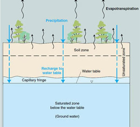
Forested areas and agricultural land in the watershed will absorb or “shed” the snow melt in spring, and rain. Some of the moisture will be absorbed by trees, shrubs and grasses, agricultural crops; the excess water will run along the surface in creeks, streams, finding its way into ponds, lakes and reservoirs, and on into rivers and eventually back to the sea. Some of this moisture will soak down through the ground into the aquifers, the underground water bodies.
Surface water – pools of water that accumulate in low areas, including ponds, creeks, streams, rivers lakes and reservoirs. Stormwater swales are low areas that may have water for a short period following heavy rain and completely drain off and dry up between rain events. Surface water can soak into the ground and join the underground water bodies (aquifers), be taken up by growing plants and trees, with excess water following the lay of the land by gravity, flowing down into other water bodies and/or evaporating and accumulating in the atmosphere.
Search for information on your local surface water quality at US Geological Survey here.
Ground water – the moisture that seeps through layers of sand, silt and clay, flows between layers of rock and gravel underground. According to the US Geological Survey, there is 1000 times more water underground than in all the surface rivers and lakes.
What is groundwater? - USGS (Click on image)
Water is a solvent, meaning that particles of various materials can be picked up by the stream, and dissolved or suspended in water. As the water flows through the watershed’s sand, silt, clay and rock, every trickle of water picks up microscopic living organisms like bacteria, fungus, protozoa, ciliates, nematodes along with minerals, metals, and chemical compounds in the path of the stream.
Check the New York State Department of Environmental Conservation for surface and groundwater quality reports for your watershed.
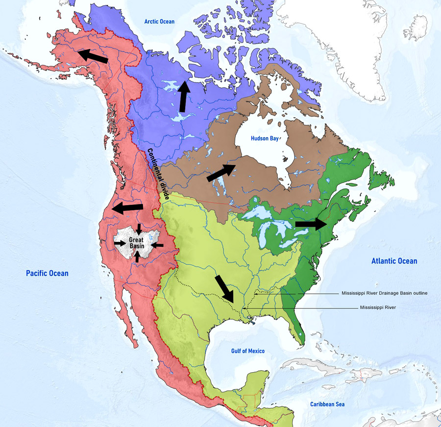
The North American Continent Outflows
Drinking water quality is impacted by human activities and natural processes occurring on the higher ground above the watershed’s outflow point.
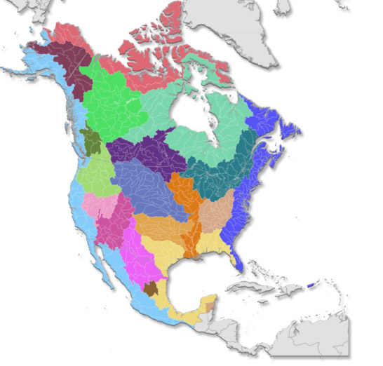
What defines a drainage basin is the point of outflow; all of the land that drains water to the outflow point is the watershed for that outflow location. Each major drainage basin contains many sub-watersheds.
"Watershed" is a term used interchangeably with “drainage basin” or “catchment”.
High elevations (mountains, hills, ridges) separating watersheds are called the “drainage divide”.
Lakes, streams, reservoirs and wetlands are “surface water”.
“Ground water” is that which pools underground, also called “aquifers”, this is accessed with wells.
New York State Watersheds
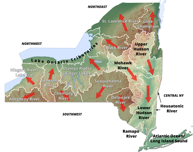
The Appalachians are the high elevation drainage divide that sends water in two directions, two major watersheds, into the Atlantic Ocean to the east and into the Ohio River system to the west, emptying into the Gulf of Mexico via the Mississippi river.
Lakes, streams and rivers are influenced by the dissolved nutrients that flow in from a variety of sources, from the breakdown of organic matter in the environment, from the expansion of micro-
organisms, from road salts and spills of all kinds of contaminants. These factors impact drinking water, alter recreational enjoyment of the water bodies, and influence the suitability of fish for human consumption.
Understanding where you are located within the drainage basin gives a better understanding where to look for water quality impacts.
In our weekly reports:
High Flows: US Geological Survey WaterWatch, NYS monitoring stations as at Jul 28/21
This section highlights the creeks and rivers in each NYS Watershed that are flowing more than 90% above normal levels, “much higher than normal” to “high”. Each system reporting high flow shows percentage increase over mean flow rate, with discharge in cubic feet per second as of the report date.
HABs Report: from the NYS Department of Environmental Conservation
Cyanobacteria, formerly known as “blue-green algae”, and reported as HABs (hazardous algal blooms), refers to an ancient species of bacteria that grows in water bodies where nutrients have accumulated in excess.
Cyanobacteria blooms are a serious health concern for people and animals. Contact with cyanobacteria and its toxins in lakes and ponds can cause symptoms ranging from skin rashes, nausea, diarrhea and vomiting to respiratory difficulties; the most severe impacts are liver and/or neurological damage leading to death.
Cyanobacteria may appear as spilled paint, pea soup or grass clippings floating on the water. As we cannot accurately predict when cyanobacteria will release toxins, it is recommended that all suspected blooms be avoided and reported.
Avoid contact with the bloom or the water around it; do not camp, boat or fish near a bloom as breathing in the airborne droplets can also be harmful. If you see cyanobacteria, make a report to the local health authorities or on-line through the NYS Department of Environmental Conservation.
Confirmed Bloom: means that DEC staff have determined the report fits the criteria of cyanobacteria as described by visual observation, digital images and lab test results.
Confirmed with High Toxins: means that lab test results are in excess of the defined threshholds:
- greater than or equal to 20 micrograms per liter at the shoreline
- or, greater than or equal to 10 micrograms per liter in open water.
Extent of the Bloom
means the cyanobacteria has been spotted in a defined area, extending from one to several neighbouring properties.
- “large localized” means the bloom extends to many properties, or occupies an entire cove, spread out along a large section of shoreline, or fills a specific part of the water body
- Widespread or Lakewide means that the entire body of water contains cyanobacteria, or most of the shoreline.
- Open water bloom – means cyanobacteria is found at the centre of a water body. Extra caution should be taken when open water bloom is confirmed with high toxins; this indicates that concentrations can be higher at the shoreline.
Reported By
DEC accepts reports from the public, the State Lake Associations, Department of Health and Citizens Statewide Lake Assessment Program (CSLAP) volunteers.
Spills Report:
NYS Hazardous Spills database records for the week are included for each county in the watershed, giving the date of record, the location of the spill, the cause of the spill, the contaminant and amount spilled (if known) and the resource impacted, sewer, soil, air, water.
The status of the spill is given as either open record (unresolved) or closed record (requiring no further action).
Glossary - DEC Spill Incident Terms
The DEC Spill Response program receives and compiles reports of hazardous material spills occurring anywhere in New York State. These reports are submitted through the Spill Hotline and other mechanisms, and entered by DEC spill response staff into the state's official data base of Spill Incidents Reports.
To help the user interpret the information provided in the on-line Spill Incidents Report data base, the alphabetical list below gives definitions and descriptions for the data fields that make up each spill incident report.
Address
The street address where the spill occurred, e.g. 23 South Main Street
Date Received
The date the spill was reported to the department
Cause
The action that best represents the spill cause. Below is the list of the possible causes used in spill incident reports:
- Human Error (01)
- Traffic Accident (02)
- Equipment Failure(03)
- Vandalism (04)
- Tank Test Failure (05)
- Housekeeping (06)
- Deliberate (07)
- Abandoned Drum (08)
- Tank Failure (09)
- Tank Overfill (10)
- Other (11)
- Unknown (12)
City
The town, city or village in which the spill occurred
County
The name of the New York State county in which the spill occurred
Material Spilled
The name (literal) of the hazardous material spilled. There are currently over a thousand substances in the department's list of possible materials, including hazardous chemicals, hazardous wastes, sewage and petroleum products.
Region
Numbers from 1 to 9 denote the DEC Regional Office in which the case manager for the spill incident works.
Date Spill Closed
The date the spill case was closed by the case manager in the Department of Environmental Conservation (the Department). The spill case was closed because either; a) the records and data submitted indicate that the necessary cleanup and removal actions have been completed and no further remedial activities are necessary, or b) the case was closed for administrative reasons (e.g., multiple reports of a single spill consolidated into a single spill number). The Department however reserves the right to require additional remedial work in relation to the spill, if in the future it determines that further action is necessary.
Resource Affected
The item that best represents the natural resource most affected by the spill. Below is the list of the possible resources used in DEC spill incident reports:
- On Land (1)
- In Sewer (2)
- Groundwater (3)
- Surface Water (4)
- Air (5)
Source
The item that best represents the source of the spill. The following is a list of the possible sources:
- Commercial/Industrial (01)
- Non-Commercial/Institutional (02)
- Major Facility 400,000 gal or more (03)
- Non-Major Facility 1,101 gal to 400,000 gal(04)
- Gas Station (05)
- Passenger Vehicle (06)
- Commercial Vehicle (07)
- Tank Truck (08)
- Private Dwelling (09)
- Vessel (10)
- Railroad Car (11)
- Unknown (12)
Spill Number
The identification number assigned to the incident report. The first two digits represent New York State fiscal year; the last five digits are assigned in numerical order as spills are reported. These numbers are automatically generated by the computer at the dispatch center.
Spill Date
The date the spill occurred. If the date is not known, field may be left blank, or an estimate made.
Spill Time
The time (hour and minute) the spill occurred, expressed in 24-hour format. If the time is not known, field may be left blank, or an estimate made.
Spill Name
The place or facility where the spill occurred, e.g. Tony's Pizza - Main St.
Spilled
The amount of the material spilled, in gallons or pounds. The amount field often contains an estimate made at the time the spill is reported.
Time of Call Received
The time the spill was reported to the department, expressed in 24-hour format
Unit
The units (gallons or pounds) in which the amount of material spilled is expressed
Waterbody
The name of any body of surface water affected by the spill
|
|
All rights reserved 2026 - WTNY - This material may not be reproduced in whole or in part and may not be distributed,
publicly performed, proxy cached or otherwise used, except with express permission.
|
|