2021/8/25
Watershed Report
With the Flow – NYS Watershed Report for the Week of August 23-29
By Gillian Ward
OVERVIEW
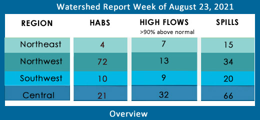
SEE BELOW FOR DETAILS
With the Flow – New York State Watershed Report for the Week of Aug 23 – 29
High Flows – Action Stage Engaged at Watertown
Report Key:
High Flows: WTNY reports systems flowing more than 90% over mean flow rate, categorized as “much above normal” and “high”, based on USGS WaterWatch real-time streamflow for Aug 23 and 24.
**Several systems are reporting peak flows approaching flood stage**, visit USGS WaterWatch for real-time stream flows.
According to Stephen Huddleston from the USGS New York Water Science Center, “Action Stage - the stage which, when reached by a rising stream, represents the level where the NWS or a partner/user needs to take some type of mitigation action in preparation for possible significant hydrologic activity. The type of action taken varies for each gage location. Gage data should be closely monitored by any affected people if the stage is above action stage.” Visit https://water.weather.gov/ahps/ NWC hydrologic prediction service for more information.
HABs – reporting all confirmed blooms of active status reported on NYHABs, reporting as of Aug 23-24
Spills Report– hazardous materials spill incidents by county, listed in the pertinent watershed, as appearing in the NYS Environmental Sites Database, Spill Incidents Database as records are uploaded, Aug 23-24.
See Watershed Basics Glossary for details on each report, or see National Weather Service high water terminology here https://www.weather.gov/aprfc/terminology
Northeast Watersheds– emptying into Atlantic Ocean via St. Lawrence River
Lake Champlain Watershed –
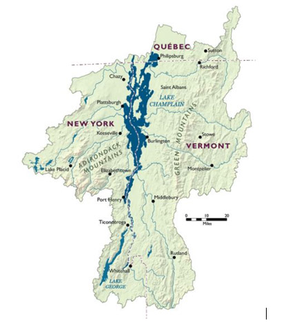
The Lake Champlain Watershed drains the area between the Adirondack Mountains in northeastern New York State and the Green Mountains in northwestern Vermont.
Includes the Ausable River, Saranac River, Great Chazy River, Boquet River, Mettawee River, Ticonderoga Creek/Lake George, Lake George,
Upper Saranac Lake, Lower Saranac Lake, Lake Placid, Lake Champlain
High Flows:
- East Branch Ausable River at Au Sable Forks is up 214% above mean to 199 cfs
- Bouquet River at Willsboro is up 250% over mean to 281 cfs
HABs:
Lake Champlain Basin Program is a multi-jurisdiction cooperative effort to protect water quality, funded by federal EPA, Vermont, New York state and Province of Quebec departments of Health and Environment.
Lake Champlain Basin
Lake Champlain: one new bloom reported
Aug 20 Lake Champlain small localized bloom confirmed in Clinton County
Check local conditions for the day of your visit, cyanobacteria blooms conditions change rapidly. For more information see the 2021 State of the Lake Report, or visit lcbp.org
Spill Report:
Clinton County:
-Equipment failure in Cadyville caused 1 gallon of hydraulic oil to be spilled on the soil 08/19/21, unresolved
Essex County:
-Unknown cause in Ticonderoga caused unknown amounts of unknown petroleum to be spilled in surface water 08/19/21, unresolved
-Equipment failure in Ticonderoga caused 200 gallons of hydraulic oil to be spilled on an unknown resource 08/17/21, unresolved
-Equipment failure in Ticonderoga caused 0.5 gallons of unknown petroleum to be spilled in the soil 08/18/21, unresolved
-Traffic accident in Minerva caused 5 gallons of motor oil and unknown amounts of anti freeze to be spilled in the soil 08/19/21, unresolved
Black River Watershed – Filters and drains most of Jefferson and Lewis Counties along with parts of Herkimer, Hamilton and Oneida Counties.
Major tributaries in the system include Moose River, Beaver River, Independence River and Deer River, Stillwater Reservoir, Fulton Chain of Lakes, Lake Lila and Big Moose Lake.
High Flows: Action Stage reached at Watertown
Black River at Boonville is flowing much above normal, up 264% to 920 cfs; Black River at Watertown peaked Sunday at 9.5 ft, just 6” from flood stage gage height of 10 ft. Gage height is down as of Aug 23 to 8.3 ft; the flow is up 889% above mean, at 15,700 cfs
Independence River at Donnattsburg is flowing much above normal, up 250% above mean flow to 209 cfs, Independence River flows into Black River.
HABs –
Spill Report :
Jefferson County:
-Human error in LeRay caused 10 gallons of gasoline to be spilled on the soil 08/16/21, unresolved
-Equipment failure in LeRay caused 20 gallons of non-PCB oil to be spilled in the soil 08/16/21, unresolved
-traffic accident in LeRay caused unknown amounts of motor oil to be spilled in the soil 08/16/21, unresolved
-Equipment failure in LeRay caused unknown amounts of hydraulic oil to be spilled in the soil, surface water, and sewer 08/17/21, unresolved
-Equipment failure in Water Town caused 300 gallons of diesel to be spilled un the soil 08/17/21, unresolved
-Human error in LeRay caused 10 gallons of antifreeze to be spilled in the soil 08/18/21, unresolved
Lewis County:
- Aug 20 Equipment failure at a gas station in Castorland caused 4lb of waste oil to spill on the pavement, the record is open
St. Lawrence River Watershed -
185 km of the St. Lawrence River catches the runoff from the northern and western Adirondack Mountains, drawing from portions of eight states, a combined area of 5600 square miles.
St. Lawrence Watershed collects the flow from eleven thousand miles of freshwater rivers and streams, including the Oswegatchie River, Raquette River, Saint Regis River, Grass River and Indian River; including Black Lake, Cranberry Lake, Raquette Lake, Tupper Lake and Long Lake. Densely forested woodlands, peatlands and areas of flat agricultural plains make up the natural surface water filtration system of this watershed area.
High Flows:
- Oswegatchie River near Oswegatchie is up 307% above mean, flowing at 919 cfs; gage height as of Aug 23 3.81 ft; at Heuvelton up 322% above mean to 1860 cfs
- West Branch Oswegatchie River near Harrisville is up 423% to 689 cfs
- Raquette River at Piercefield is flowing much above normal, up 273% above mean to 1530 cfs; at South Colton station is flowing much above normal, up 173% above mean to 2030 cfs
HAB’s report:
Aug 14 Hyde Lake large localized bloom confirmed in St. Lawrence County
Aug 18 Black Lake small localized bloom, lakewide bloom confirmed in St. Lawrence County
Spill Report
Franklin County:
-Equipment failure in Paul Smiths caused 5 gallons of motor oil to be spilled in the soil 08/19/21, unresolved
St. Lawrence County:
-Other cause in Massena caused 2 gallons of unknown material to be spilled in the soil and surface water 08/16/21, unresolved
-Equipment failure in Massena caused 10 gallons of diesel to be spilled in the soil and surface water 08/20/21, unresolved
Northwest Watersheds – empties into Atlantic Ocean via Great Lakes and St. Lawrence River
Lake Ontario and Minor Tributaries
This watershed includes the areas between the larger rivers that drain into Lake Ontario. It is divided into western, central and eastern sections that stretch all along the Lake Ontario Shoreline.
*Includes Salmon River Reservoir, Sodus Bay, North Pond, Irondequoit Bay and Perch Lake; Salmon River, Oak Orchard Creek, Irondequoit Creek, Sandy Creek
High Flows:
- Oswego River is flowing high this week at Oswego, up 867% above mean flow at 21,700 cfs
- Seneca River near Baldwinsville is flowing high, up 716% above mean to 10,400 cfs
- Sandy Creek at Adams is flowing much above normal up 412% to 213 cfs
HABs:
Aug 14 North Sandy Pond small localized bloom confirmed in Oswego County
Aug 17 Lake Neahtahwanta widespread/lakewide bloom confirmed in Fulton County
Aug 18 Hyde Park Lake large localized bloom confirmed in Niagara County
Aug 20 Gill Creek small localized bloom confirmed in Niagara County
North Sandy Pond – widespread or lakewide bloom confirmed Aug 5 in Oswego County has been archived.
Spill Report
Orleans County: no spills reported
Wayne County: no spills reported
Oswego County:
- Housekeeping at a private residence on Ontario Street in Oswego caused an unknown amount of an unknown contaminant on Aug 14, the record is open
- Equipment failure at a private residence in Phoenix caused an unknown amount of kerosene to spill on the soil on Aug 17, the record is open
- For unknown reasons, unknown amounts of engine oil and gasoline were spilled from a vessel on Lake Oneida near Constantia, the record is open
- North Sandy Pond was the scene of an incident with a mini-excavator, the commercial equipment became submerged an unknown amount of diesel fuel entered the surface water and soil, Aug 20, the record was closed Aug 23
- On Aug 21 at Sandy Pond Marina, a commercial vehicle leaked an unknown amount of hydraulic oil into surface water at Sandy Creek
Niagara River/Lake Erie Watershed
The Niagara River drains an area encompassing more than 265,000 square miles in the north central United States and south central Canada, including Tonawanda Creek, Cattaraugus Creek, Buffalo River; Attica Reservoir and Lime Lake.
High Flows:
Cattaraugus Creek at Gowanda is flowing much above normal, up 173% above mean at 483 cfs
HABs:
Aug 16 Java Lake open water bloom confirmed for Wyoming County
Spill Report
Erie County:
-Equipment failure in Buffalo caused 1 gallon of hydraulic oil to be spilled on an unknown resource 08/16/21, resolved 08/16/21
-Unknown cause in Buffalo caused unknown amounts of unknown petroleum to be spilled in the soil 08/16/21, unresolved
-Other cause in Clarence caused unknown amounts of other material to be spilled on an unknown resource 08/16/21, unresolved
-Equipment failure in Hamburg caused 20 gallons of gasoline to be spilled in the soil and sewer 08/16/21, resolved 08/16/21
-Equipment failure in Tonawanda caused 3 gallons of transformer oil to be spilled in the soil 08/17/21, unresolved
-Equipment failure in Buffalo caused 1 gallon of transformer oil to be spilled on an unknown resource 08/18/21, resolved 08/18/21
-Equipment failure in Buffalo caused 3 gallons of non-PCB oil to be spilled in the soil 08/19/21, resolved 08/20/21
-Unknown cause in Buffalo caused unknown amounts of unknown petroleum to be spilled on an unknown surface 08/20/21, unresolved
Niagara County:
-Equipment failure in Lewiston caused unknown amounts of water treatment comp to be spilled on an unknown resource 08/17/21, resolved 08/17/21
-Unknown cause in Lockport caused unknown amounts of unknown petroleum to be spilled in surface water 08/17/21, unresolved
-Traffic accident in Royalton caused 30 gallons of diesel to be spilled on an unknown resource 08/17/21, unresolved
-Equipment failure in Lockport caused unknown amounts of transformer oil to be spilled on an unknown resource 08/19/21, unresolved
Oswego River and Finger Lakes Watershed
Including Otisco, Skaneateles, Owasco, Cayuga, Oneida, Seneca, Keuka, Canandaigua and Canadice Lakes; Oneida River, Clyde River, Cayuga Lake Tributaries, and Seneca Lake Tributaries
High Flow:
- Canandaigua Outlet at Chapin is flowing high this week, up 1128% above mean at 555 cfs; gage height has leveled out at just over 5 ft, up 2ft from last week at this time
- Keuka Lake Outlet at Dresden is flowing high, up 1869% above mean at 1090 cfs; gage height is just under 5 ft, down by almost half since Aug 19
- Flint Creek at Phelps is flowing much above normal, 745% above mean at 120 cfs
- Onandaga Creek at Spencer St. Syracuse is much above normal, up 652% above mean to 577 cfs
- Tioughnioga River at Cortland is flowing high, up 1129% above mean at 1720 cfs
- Otselic River at Cincinnatus is flowing high, up 4319% above mean to 2880 cfs, gage height peaked just above 6ft on Aug 23
- Fall Creek near Ithaca is much above normal, up 515% to 309 cfs
- East Branch of Fish Creek at Taberg is flowing much above normal, up 271% to 504 cfs
HABs: The total number of HABs reported went from 26 to 58 over the course of two days:
Aug 10 Yogi and Boo Boo’s Campground Pond lakewide bloom remains active
Aug 11-22 Skaneateles Lake, 7 active HABs including small localized blooms confirmed in Cortland County remains active
Aug 13 Owasco Outlet, small localized bloom confirmed in Cayuga County remains active
Aug 14 Cayuga Lake, small localized bloom confirmed in Cayuga County
Aug 15-16 Owasco Lake 10 new HABs reported, small and large localized confirmed in Cayuga County
Aug 15 Canandaigua Lake, 13 new HABs including small and large localized blooms confirmed in Ontario County
Aug 16 Keuka Lake, widespread bloom confirmed in Yates County, small localized bloom confirmed in Yates County
Aug 20 Keuka Lake, 4 new HABs including small and large localized blooms confirmed in Steuben and Yates Counties
Aug 15-22 Owasco Lake, 10 active HABs including small and large localized blooms confirmed in Cayuga County
Aug 20 Cayuga Lake, 9 new HABs including large and small localized blooms confirmed in Cayuga County
Check local conditions before venturing out to the lakes this week, HABs appear rapidly and toxins may remain in the water for a period after the bloom is gone.
Spill Report:
Seneca County:
-Currently no spills for this week
Cayuga County:
-Deliberate cause in Gorton caused unknown amounts of manure to be spilled in the soil 08/16/21, resolved 08/16/21
Schuyler County:
-Currently no spills for this week
Yates County:
-Currently no spills for this week
Ontario County:
-Other cause in Victor caused unknown amounts of transformer oil to be spilled on an unknown resource 08/17/21, unresolved
-Unknown cause in Canandaigua caused 1 gallon of gasoline to be spilled in surface water 08/18/21, unresolved
Genesee River Watershed
Including: Conesus Lake, Silver Lake, Mount Morris Reservoir, Hemlock Lake, Honeoye Lake; Cassadaga Creek, Honeoye Creek, Oatka Creek, Black Creek
High Flows:
- Genesee River at Ford Street Bridge, Rochester is much above normal, flowing at 556% above mean at 5660 cfs; at Avon flowing high, 831% above mean at 4900 cfs; at Mt. Morris flowing high, 995% above mean at 4710 cfs; at Portageville 566% much above mean at 1780 cfs; at Wellsville reached flood stage, peaking at 11ft Aug 19, flowing 610% above mean at 605 cfs, gage height is down to 5.45 ft Aug 24
HABs:
Aug 17 Conesus Lake, large localized bloom confirmed in Livingston County
Aug 17 Avon Marsh Dam Pond, large localized bloom confirmed on the north shore, Livingston County
Aug 19-22 Honeoye Lake, 7 new HABs reported, including small and large localized blooms, confirmed in Ontario County
Spill Report:
Livingston County:
-Currently no records for this week
Allegany County:
-Currently no records for this week
Monroe County:
-Equipment failure in Rochester caused 7 gallons of hydraulic oil to be spilled on an unknown resource 08/16/21, unresolved
-Equipment failure in north Greece caused unknown amounts of gasoline to be spilled on an unknown resource 08/16/21, unresolved
-Equipment failure in Rochester caused 10 gallons of gasoline to be spilled on an unknown resource 08/17/21, unresolved
-Equipment failure in Wheatland caused 1 gallon of hydraulic oil to be spilled on the soil 08/18/21, unresolved
-unknown cause in Rochester caused unknown amounts of other material to be spilled on the soil and ground water 08/18/21, unresolved
-Equipment failure in Webster caused unknown amounts of antifreeze to be spilled on an unknown resource 08/20/21, resolved 08/20/21
-Equipment failure in Webster caused 1 gallon of transformer oil to be spilled in the soil 08/20/21, unresolved
-Equipment failure in Rochester caused 1 gallon of transformer oil to be spilled in the soil 08/20/21, unresolved
Genesee County:
-Human error in Pembrooke caused 15 gallons of diesel to be spilled on an unknown surface 08/19/21, unresolved
-Other cause in Pembrooke caused 15 gallons of diesel to be spilled on aan unknown resource 08/19/21, unresolved
Wyoming County:
-Equipment failure in Varysburg caused 5 gallons of transformer oil to be spilled on the soil 08/20/21, unresolved
Southwest Watersheds – emptying into Gulf of Mexico via Ohio River/Mississippi River; emptying into Atlantic Ocean via Chesapeake Bay
Allegheny River Watershed (flowing west into Ohio River system)
Including Allegheny River, Chadakoin River, Conewango Creek, Canaseraga Creek, Cassadaga Creek, Olean Creek, Great Valley Creek, French Creek, Allegheny Reservoir, Chautauqua Lake
High Flows:
- Chadakoin River at Falconer is flowing much above normal, up 398% above mean flow, 304 cfs
- Allegheny River at Salamanka is flowing much above normal, up 362% above mean, 2520 cfs
- Canaseraga Creek above Dansville is flowing much above normal, up 242% above mean flow to 57 cfs
HABs:
Aug 13 Red House Lake small localized bloom confirmed in Cattaraugus County remains active
Aug 14 Chautauqua Lake large localized bloom confirmed in Cattaraugus County remains active
Aug 15 Quaker Lake, new small localized bloom confirmed in Cattaraugus County
Aug 16, 17 Allegheny Reservoir, 2 new large localized blooms confirmed in Cattaraugus County
Aug 20 Chautauqua Lake, 1 new small localized bloom confirmed in Chautauqua County
Aug 20-22 Chautauqua Lake 2 new widespread/lakewide blooms confirmed in Chautauqua County
Spill Report:
Cattaraugus County:
-Currently no records for this week
Chautauqua County:
-Equipment failure in Cassadaga caused unknown amounts of diesel to be spilled on an unknown resource 08/16/21, resolved 08/16/21
-Storm in Poland caused 10 gallons of transformer oil to be spilled on the soil 08/18/21, unresolved
-Vandalism in Bemus point caused 5 gallons of gasoline to be spilled on the soil 08/19/21, unresolved
Chemung River Watershed
The Chemung River flows across the western portion of Southern Tier of New York State before joining the Susquehanna River and eventually emptying into the Chesapeake Bay.
Including Cohocton River, Tioga/Canisteo River; Lamoka Lake/Mill Pond, Waneta Lake, Almond Lake
High Flows:
- Canisteo River at Arkport is flowing much above normal up 331% to 14.3 cfs; below Canacadea Creek at Hornell up 317% above mean flow to 129 cfs; up 745% at West Cameron to 460 cfs and gage height 5ft
- Tiogo River near Erwins is flowing much above normal, up 703% to 3070 cfs
- Chemung River at Corning is flowing much above normal, up 806% above mean to 4690 cfs, gage height 17 ft (flood stage is 29 ft); at Chemung, much above normal, up 720% above mean to 6310 cf
HABs: none reported
Spill Report:
Chemung County:
-Currently no spills for this week
Steuben County:
-Equipment failure in Wayland caused 4 gallons of hydraulic oil to be spilled on an unknown resource 08/16/21, resolved 08/18/21
-Traffic accident in Wayland caused 4 gallons of transformer oil to be spilled in the soil 08/16/21, unresolved
-Unknown cause in Hornell caused unknown amounts of gasoline to be spilled in the soil 08/18/21, unresolved
Susquehanna River Watershed
The Susquehanna River drains 27,500 square miles covering large parts of New York, Pennsylvania and Maryland before emptying into the Chesapeake Bay.
Including: Chenango River, Tioughnioga River, Unadilla River, Owego Creek; Otsego Lake, Canadarago Lake, Whitney Point Lake/Reservoir
High Flows
- Susquehanna River at Unadilla is up 484% to 1660 cfs; at Conklin up 472% above mean flow to 5170 cfs, at Vestal flowing high, up 867% to 14400 cfs, gage height 9.82 ft; near Waverly is flowing high, up 801% to 16,400 cfs;
- Unadilla River at Rockdale is flowing much above normal, up 369% to 810 cfs
- Chenango River at Green is flowing high, up 1371% to 2640 cfs; near Chenango Forks flow is up 1154% above mean, 9120 cfs
HABs –
Aug 16 Unnamed water, small localized bloom confirmed in Broome County
Aug 22 Beaver Lake, small localized bloom confirmed in Broome County
Spill Report:
Broome County:
-Equipment failure in Stanford caused unknown amounts of hydraulic oil to be spilled in the soil 08/16/21, resolved 08/23/21
-Human error in Binghamton caused 3 gallons of motor oil to be spilled in the soil, and sewer 08/17/21, resolved 08/23/21
-Equipment failure in Maine caused 0.25 gallons of diesel to be spilled on an unknown surface 08/18/21, unresolved
-Equipment failure in Endicott caused 15 gallons of fertilizers to be spilled in the soil 08/19/21, resolved 08/20/21
-Other cause in Binghamton caused 5 gallons of paint to be spilled on an unknown resource 08/20/21, unresolved
-Equipment failure in vestal caused unknown amounts of transformer oil to be spilled in the soil 08/20/21, unresolved
Chenango County:
-Equipment failure in Gilford caused unknown amounts of #2 fuel oil to be spilled on the soil 08/17/21, resolved 08/23/21
Cortland County:
-Traffic accident in Cortland Ville caused unknown amounts of gasoline to be spilled on an unknown resource 08/19/21, unresolved
-Other cause in Homer caused unknown amounts of wastewater to be spilled on an unknown resource 08/20/21, resolved 08/20/21
Otsego County:
-Deliberate cause in South Edmeston caused unknown amounts of manure to be spilled on an unknown resource 08/20/21, resolved 08/20/21
Tioga County:
-Equipment failure in Newark Valley caused unknown amounts of Kerosene to be spilled on the soil 08/16/21, unresolved
Central NY Watersheds emptying into Altantic Ocean at Long Island Sound
Mohawk River Watershed
The Mohawk River originates in the western Adirondacks and the Tug Hill Plateau and flows 140 miles to the east where it joins the Hudson River. Sections of the Mohawk River also serve as the New York State Barge (Erie) Canal.
Including Schoharie Creek, West Canada Creek, East Canada Creek; Hinkley Reservoir, Delta Reservoir, Peck Lake, Schoharie Reservoir; joins the Hudson River below Albany.
High Flows:
- Mohawk River below Delta Dam near Rome is flowing much above normal, up 277% above mean to 684 cfs; near Little Falls is much above normal up 285% to 3570 cfs; at Cohoes much above normal at over 1000% above mean and dumping 20,500 cfs into the Hudson system
- Otsquago Creek at Fort Plain is flowing high, up 632% above mean to 59 cfs
- West Canada Creek at Cast Bridge is flowing high, up 316% above mean to 1980 cfs
- Schoharie Creek is flowing much above normal at Prattsville, up 860% to 2630 cfs; picking up speed at North Blenheim, flowing high, up 9537% to 5230 cfs; still high at Breakabeen, up 7371% above mean at 6470 cfs; still high at Burtonsville, up 5758% above mean to 9700 cfs, gage height 4 ft is 2/3 of flood stage
- Manor Kill at West Conesville near Gilboa is rated high, flowing over 900% above mean at 122 cfs
- Mine Kill near North Blenheim is flowing 676% above mean at 33 cfs where it meets up with Schoharie Creek
HABs – none reported
Spill Report
Montgomery County:
-Unknown cause in Fonda caused unknown amounts of diesel to be spilled on an unknown resource 08/19/21, unresolved
Schoharie County:
-Currently no records for this week
Upper Hudson River Watershed
The Upper Hudson River Watershed drains the south side of the Adirondack Mountains and flows south to meet the Mohawk River.
Including Sacandaga River, Schroon River, Fish Creek, Hoosic River, Batten Kill, Great Sacandaga Lake, Indian Lake, Schroon Lake, Saratoga Lake
High Flows
- Hudson River near Newcomb is flowing much above normal this week, up 258% to 420 cfs; flowing much above normal at North Creek, up 361% to 2890 cfs; flowing high this week at Fort Edward, 257% above mean flow, discharging 7990 cfs; at Stillwater is up 187% to 7090 cfs; above Lock 1 near Waterford hits a high flow rate, 354% above mean to 14,100 cfs; at Green Island, just below the confluence with Mohawk River, flow is rated high, up 601% above mean to 37,700 cfs
- Indian River near Indian Lake is flowing much above normal, up 219% above mean flow to 791cfs, Indian River joins Hudson River
- Sacandaga River near Hope is flowing much above normal, up 480% above mean to 1600 cfs; hitting high stride at Stewart’s Bridge near Hadley, flowing 212% above mean at 4080 cfs
- Glowegee Creek at West Milton is flowing much above normal, up 267% to 32 cfs
- Hoosic River near Eagle Bridge is flowing high up 1658% to 3250 cfs
- Batten Kill below Mill at Battenville is flowing much above normal, up 264% to 720 cfs
HABs
Aug 16 Friends Lake small localized bloom confirmed in Warren County
Spill Report
Saratoga County:
-Traffic accident in Saratoga Springs caused 20 gallons of transformer oil to be spilled in the soil 08/16/21, unresolved
-Equipment failure in Saratoga Springs caused 2 lbs of motor oil to be spilled on an unknown resource 08/16/21, resolved 08/17/21
-Equipment failure in Clifton Park caused 2 gallons of hydraulic oil to be spilled on an unknown resource 08/16/21, unresolved
-Equipment failure in Wilton caused unknown amounts of raw sewage to be spilled in the soil 08/16/21, unresolved
-Equipment failure in Balston Lake caused 1 gallon of transformer oil to be spilled in the soil 08/17/21, unresolved
-Unknown cause in Balston Spa caused unknown amounts of unknown petroleum to be spilled on an unknown resource 08/18/21, unresolved
Washington County:
-Currently no records for this week
Warren County:
-Unknown cause in lake George caused unknown amounts of gasoline to be spilled on an unknown resource 08/18/21, unresolved
-Unknown cause in Queensbury caused unknown amounts of unknown petroleum to be spilled on an unknown resource 08/18/21, unresolved
-Unknown cause in Diamond Point caused unknown amounts of motor oil to be spilled on the surface water 08/20/21, unresolved
Lower Hudson River Watershed
The Lower Hudson Watershed begins where the Mohawk River joins the Hudson system at the Troy Dam and extends down to Manhattan. The lower end of the Hudson system, 153 miles, is technically a tidal estuary, not a river.
Rondout/Wallkill Rivers, Stockport/Kinderhook Creeks, Catskill Creek, Esopus Creek, Croton River; Ashokan Reservoir, Rondout Reservoir, New Croton Reservoir, Alcove Reservoir, Cross River Reservoir, Muscoot/Upper New Croton Reservoir
High Flows:
- Platte Kill near Dunraven is flowing high, up 666% to 124 cfs
- Valatie Kill near Nassau is flowing much above normal, up 639% to 39 cfs
- Esopus Creek at Mount Marion is flowing high, up 1269% to 2010 cfs
- Rondout Creek at Rosendale is flowing high 1181% to 2030 cfs
- Kinderhook Creek at Rossman is flowing high, up 2428% to 2740 cfs
- Wappinger Creek near Wappingers Falls is flowing much above normal, up 445% to 371 cfs
- Chestnut Creek at Grahamsville is flowing much above normal, up 241% to 30 cfs
- Croton River at New Croton Dam near Croton-on-Hudson is flowing much above mean, flowing up 949% to 1320 cfs
HABs
Aug 15 Walkill Pond open water bloom confirmed in Ulster County
Aug 19 Glass Lake, lakewide bloom confirmed in Rennselaer County
Aug 16 Orange Lake small localized bloom confirmed in Orange County, the Aug 9 widespread bloom is archived.
Aug 10 Kirk Lake small localized bloom confirmed in Putnam County remains active.
Spill Report
Westchester County:
-Equipment failure in Mohegan Lake caused unknown amounts of #2 fuel oil to be spilled in the soil 08/16/21, unresolved
-Unknown cause in Peekskill caused unknown amounts of gasoline to be spilled on the soil 08/16/21, unresolved
-Equipment failure in White Plains caused unknown amounts of #2 fuel oil to be spilled in the soil 08/16/21, unresolved
-Equipment failures in Somers caused unknown amounts of gasoline to be spilled on an unknown resource 08/18/21, unresolved
-Equipment failure in south salem caused unknown amounts of #2 fuel oil to be spilled on the soil 08/19/21, unresolved
-Unknown cause in Bronxville caused unknown amounts of unknown material to be spilled in the surface water 08/19/21, resolved 08/20/21
-Equipment failure in Millwood caused unknown amounts of motor oil to be spilled on an unknown resource 08/19/21, resolved 08/19/21
-Equipment failure in Bedford caused unknown amounts of #2 fuel oil to be spilled on an unknown resource 08/20/21, unresolved
-Tank Test Failure in Bronxville caused unknown amounts of #2 fuel oil to be spilled in the soil 08/20/21, unresolved
Orange County:
-Equipment failure in Middletown caused unknown amounts of #2 fuel oil to be spilled in the soil 08/16/21, unresolved
-unknown cause in chester caused unknown amounts of unknown petroleum to be spilled on the soil 08/16/21, unresolved
-Traffic accident in Kiryas Ville caused 10 gallons of non PCB oil to be spilled on the soil 08/16/21, unresolved
-Equipment failure in Middletown caused unknown amounts of #2 fuel oil to be spilled on the soil 08/19/21, unresolved
-Other cause in Monroe caused unknown amounts of #2 fuel oil to be spilled on an unknown resource 08/20/21, unresolved
-Equipment failure in Wallkill caused 1 gallon of transformer oil to be spilled on the soil 08/20/21, unresolved
Putnam County:
-Other cause in Southeast caused 3.25 gallons of diesel to be spilled on the soil 08/20/21, unresolved
Columbia County:
-Equipment failure in Canaan caused unknown amounts of #2 fuel oil to be spilled on an unknown resource 08/18/21, unresolved
Delaware River Watershed
The headwaters flow down from the Catskill Mountains into Delaware Bay/Atlantic Ocean. The watershed area includes East Branch Delaware River, West Branch Delaware River, Neversink River, Mongaup River, Pepacton Reservoir, Cannonsville Reservoir and Neversink Reservoir.
High Flows:
- Trout Creek is up 374% to 43 cfs, much above normal at Trout Creek
- West Branch Delaware River at Walton is flowing high, up 980% to 1510 cfs; upstream from Delhi is flowing 632% above mean at 376 cfs
- Little Delaware River near Delhi is flowing high, 1076% above mean at 245 cfs;
- East Branch Delaware near Harvard is flowing 271% above mean at 797 cfs
- Tremper Kill near Andes is flowing high, up 946% above mean at 153 cfs
- Beaver Kill at Cooks Falls is flowing much above normal up 326%, to 944 cfs
- Mill Brook near Dunraven is flowing high 639% above mean at 91 cfs
- Neversink River near Claryville is flowing much above normal, up 358% to 352 cfs; at Goddeferoy is up 348% to 802%
HABS:
Aug 8 Mountain Lake widespread or lakewide bloom confirmed in Sullivan County
Aug 9 Montgomery Lake small localized bloom confirmed in Sullivan County
Aug 10 Cannonsville Reservoir large localized bloom confirmed in Delaware County
Spill Report:
Sullivan County:
-Equipment failure in Wurtsborno caused 1 gallon of #2 fuel oil to be spilled on the soil 08/18/21, resolved 08/19/21
-Abandoned drums in Liberty caused unknown amounts of unknown petroleum to be spilled on an unknown resource 08/19/21, unresolved
-Unknown cause in Wartsboro caused unknown amounts of unknown petroleum to be spilled on the soil, 08/20/21. Unresolved
-Equipment failure in Kiamesha caused unknown amounts of #2 fuel oil to be spilled on the groundwater and soil 08/20/21, unresolved
-unknown cause in Roscoe caused unknown amounts of unknown petroleum to be spilled in the soil 08/20/21, unresolved
Delaware County:
-Equipment failure in Walton caused 10 gallons of hydraulic oil to be spilled in the soil 08/19/21, resolved 08/23/21
Ulster County :
-Equipment failure in Kingston caused unknown amounts of #2 fuel oil to be spilled in the soil 08/18/21, unresolved
-Equipment failure in Woodstock caused 30 gallons of hydraulic oil to be spilled on an Impervious surface 08/20/21, resolved 08/20/21
Housatonic River Watershed
A small portion of the headwaters of the Housatonic lie in eastern New York State. These waters drain the Taconic and Berkshire Mountains before joining the Housatonic and eventually emptying into Long Island Sound. Includes Tenmile River, Green River, Indian Lake, Swift/Crane Ponds
High Flow:
- Housatonic River near Great Barrington is flowing high, up 1036% to 2320 cfs
HABs: none reported
Spill Report:
Dutchess County:
-Unknown cause in Poughkeepsie caused unknown amounts of unknown petroleum to be spilled in the soil 08/16/21, unresolved
Ramapo River Watershed
The northern headwaters of the Passaic basin lie within a small portion of southeastern New York State, including the Ramapo and Hackensack Rivers drainage areas. It is the smallest watershed in New York State. Including Ramapo River, Hackensack River, Greenwood Lake, DeForest Lake.
High Flow:
- Hackensack River has gone from much below normal at 9 cfs to a high flow this week, up 503% above mean flow to 122 cfs
- Mahwah River near Suffern is flowing high, up 1113% to 59 cfs
HABs: none reported
Spills Report
Rockland – Equipment failure in New City caused 5 gallons of transformer oil to be spilled in the soil 08/17/21, unresolved
-Equipment failure in Suffern caused unknown amounts of #2 fuel oil to be spilled in the soil 08/19/21, unresolved
Atlantic Ocean/Long Island Sound Watershed
The Atlantic Ocean/Long Island Sound Watershed drains most of the New York City Metropolitan Area and all of Long Island. The drainage area includes all marine waters in New York Harbor, Long Island Sound, Block Island Sound, and along the South Shore of Long Island, and the fresh waters that drain into them.
Includes 1415 square miles of marine estuary waters, the Bronx River, Mamaroneck River, Mianus River, Peconic River, Kensico Reservoir, Lake Ronkonkoma.
High Flow:
- Carlls River at Babylon is flowing much above normal, 181% above mean flow at 36 cfs as of Aug 25
- Mill Neck Creek at Mill Neck is flowing much above normal, 163% above mean at 13 cfs
HABs
Aug 10 Wainscott Pond 2 new HABs, widespread/lakewide bloom confirmed in Suffolk County
Aug 15 Little Fresh Pond, open water bloom confirmed in Suffolk County
Aug 16 Maratooka Lake widespread bloom confirmed in Suffolk County
Aug 17 Indian Pond lakewide bloom confirmed in Bronx County
Aug 17 Agawam Lake widespread bloom confirmed in Suffolk County
Aug 13, 18 Mill Pond (Watermill) 2 new HABS, lakewide blooms confirmed in Suffolk County
Aug 17 Fort Pond 2 new HABs, widespread/lakewide blooms confirmed in Suffolk County
Aug 18 Prospect Park Lake widespread/lakewide bloom confirmed in Kings County
Aug 18 Georgica Pond, large localized bloom confirmed in Suffolk County is still active
Aug 21 The Lake In Central Park widespread bloom confirmed in Manhattan
Spill Report:
Kings (Brooklyn):
-Equipment failure in Brooklyn caused 0.25 gallons of hydraulic oil to be spilled in the soil 08/18/21, unresolved
-Abandoned drums in Brooklyn caused unknown amounts of unknown material to be spilled on an unknown resource 08/19/21, resolved 08/19/21
-Abandoned drums in Brooklyn caused unknown amounts of unknown petroleum to be spilled on an unknown resource 08/19/21, unresolved
-Unknown cause in Brooklyn caused 0.5 gallons of unknown petroleum to be spilled on the soil 08/20/21, unresolved
Queens County:
-Housekeeping in Queens caused 3 gallons of dielectric fluid to be spilled on the soil 08/16/21, unresolved
-Deliberate cause in Ridgewood caused 5 gallons of motor oil to be spilled on an Impervious surface 08/16/21, unresolved
Nassau County:
-Traffic accident in Hempstead caused 20 gallons of gasoline to be spilled in the soil 08/16/21, unresolved
-Equipment failure in Bellmore caused 3 gallons of transformer oil to be spilled on an impervious surface 08/16/21, unresolved
-Equipment failure in Old Bethpage caused unknown amounts of #2 fuel oil to be spilled in the soil and impervious surface 08/16/21, resolved 08/18/21
-Unknown cause in Great Neck caused unknown amounts of Waste oil to be spilled on an impervious surface 08/17/21, unresolved
-Equipment failure in Elmont caused unknown amounts of #2 fuel oil to be spilled on an unknown surface 08/17/21, unresolved
-Equipment failure in Glen Cove caused 35 gallons of hydraulic oil to be spilled on an unknown surface 08/17/21, unresolved
-Human error in east Norwich caused unknown amounts of #2 fuel oil to be spilled on an unknown resource 08/18/21, unresolved
Suffolk County:
-Equipment failure in Montauk caused 1 gallon of transformer oil to be spilled in the soil 08/16/21, unresolved
-Equipment failure in Bridgehampton caused unknown amounts of diesel to be spilled on an unknown resource 08/16/21, unresolved
-Equipment failure in ISLIP caused 0.25 gallons #2 fuel oil to be spilled on an impervious surface 08/17/21, resolved 08/17/21
-Equipment failure in Port Jefferson caused 4 gallons of diesel to be spilled on the soil 08/19/21, unresolved
-Traffic accident in Muttituck caused 70 gallons of diesel to be spilled in the soil 08/19/21, unresolved
-Other cause in Babylon caused unknown amounts of unknown petroleum to be spilled in the groundwater 08/19/21, resolved 08/19/21
-Equipment failure in Greenlawn caused 30 gallons of hydraulic oil to be spilled in the soil 08/19/21, unresolved
-Equipment failure in Farmingville caused 5 gallons of #2 fuel oil to be spilled in the soil 08/19/21, unresolved
-Equipment failure in Cherry Grove caused 15 gallons of transformer oil to be spilled in the soil 08/20/21, unresolved
-Equipment failure in Lindenhurst caused 1 gallon of #2 fuel oil to be spilled on the soil and impervious surface 08/20/21, unresolved
Richmond County:
-equipment failure in Staten Island caused unknown amounts of dielectric fluid to be spilled on an unknown resource 08/19/21, unresolved
-Unknown cause in Staten Island caused unknown amounts of fuel to be spilled in surface water 08/18/21, resolved 08/19/21
Bronx County:
-Unknown cause in Bronx caused 3 gallons of unknown petroleum to be spilled on the soil and impervious surface 08/16/21, resolved 08/19/21
-Unknown cause in the Bronx caused unknown amounts of unknown petroleum to be spilled in the soil and groundwater 08/20/21, unresolved
-Equipment failure in the Bronx caused 15 gallons of #4 fuel oil to be spilled in the soil 08/20/21, resolved 08/23/21
|