2021/9/1
Watershed Report
With the Flow – NYS Watershed Report for the Week of August 30-September 3
Oswego/Finger Lakes explodes with new HABs, 110 confirmed blooms
By Gillian Ward
OVERVIEW
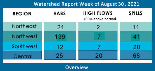
SEE BELOW FOR DETAILS
With the Flow – New York State Watershed Report for the Week of Aug 30 – Sept 5
Oswego/Finger Lakes Explodes with new HABs, 110 confirmed blooms
High Flows – down this week in most parts of NYS
Report Key:
High Flows – WTNY reports systems flowing more than 90% over mean flow rate, categorized as “much above normal” and “high”, based on USGS WaterWatch real-time streamflow for Aug 30-31.
**Several systems are reporting peak flows approaching flood stage**, visit USGS WaterWatch for real-time stream flows.
See also, National Weather Service high water terminology here https://www.weather.gov/aprfc/terminology
HABs – reporting confirmed hazardous algal blooms (cyanobacteria) confirmed as active on NYS HABs Notice, for the period Aug 30-Sep 5
Oswego Finger Lakes Watershed Confirmed HABs Quadrupled this week
Spills Report– hazardous materials spill incidents by county, listed in the pertinent watershed, as appearing in the NYS Environmental Sites Database, Spill Incidents Database as records are uploaded, covering the period Aug 21-28.
See Watershed Basics Glossary for details on each report.
Northeast Watersheds– emptying into Atlantic Ocean via St. Lawrence River
Lake Champlain Watershed –
The Lake Champlain Watershed drains the area between the Adirondack Mountains in northeastern New York State and the Green Mountains in northwestern Vermont.
Includes the Ausable River, Saranac River, Great Chazy River, Boquet River, Mettawee River, Ticonderoga Creek/Lake George, Lake George,
Upper Saranac Lake, Lower Saranac Lake, Lake Placid, Lake Champlain
High Flows: all within normal range or below normal
HABs:
Lake Champlain Basin Program is a multi-jurisdiction cooperative effort to protect water quality, funded by federal EPA, Vermont, New York state and Province of Quebec departments of Health and Environment.
Lake Champlain Basin
Aug 25 Lake Champlain 2 small localized blooms confirmed in Essex County
Aug 23 Lake Champlain 2 small localized blooms confirmed in Clinton County
Aug 21 Lake Champlain large localized bloom confirmed in Essex County, 2 small localized blooms confirmed in Essex County
Lake Champlain small localized bloom confirmed in Clinton County on Aug 20 remains active this week.
Check local conditions for the day of your visit, cyanobacteria blooms conditions change rapidly. For more information see the 2021 State of the Lake Report, or visit lcbp.org
Spill Report:
Clinton County:
-Equipment failure in Saranac caused 15 gallons of hydraulic oil to be spilled on an unknown surface 08/23/21, unresolved
-Other cause in Morrisonville caused 1 gallon of soap and laundry soap to be spilled in the soil 08/26/21, resolved 08/31/21
Essex County:
-Equipment failure in Lake Placid caused unknown amounts of #2 fuel oil to be spilled in the soil 08/25/21, unresolved
-Equipment failure in Saranac Lake caused 0.1 gallons of power steering fluid to be spilled on an impervious surface 08/27/21, unresolved
Black River Watershed – Filters and drains most of Jefferson and Lewis Counties along with parts of Herkimer, Hamilton and Oneida Counties.
Major tributaries in the system include Moose River, Beaver River, Independence River, and Deer River, Stillwater Reservoir, Fulton Chain of Lakes, Lake Lila, and Big Moose Lake.
High Flows:
Black River at Watertown has slowed considerably since last week’s high water triggered an action stage. Still flowing much above normal this week, the Black River is 225% above mean flow, discharging 3960 cfs, down from a peak flow of 15,700 cfs last week. Gage height is back under 5ft this week from a peak last week of 9.5ft.
HABs – none reported
Spill Report :
Jefferson County:
-Equipment failure in Fort Drum caused 3 gallons of hydraulic oil to be spilled in the soil 08/23/21, unresolved
-Human error in Fort Drum caused 3 gallons of gasoline to be spilled in the soil 08/23/21, unresolved
-Equipment failure in Philadelphia caused unknown amounts of #2 fuel oil to be spilled on an unknown resource, 08/25/21, unresolved
Lewis County: -none reported
St. Lawrence River Watershed -
185 km of the St. Lawrence River catches the runoff from the northern and western Adirondack Mountains, drawing from portions of eight states, a combined area of 5600 square miles.
St. Lawrence Watershed collects the flow from eleven thousand miles of freshwater rivers and streams, including the Oswegatchie River, Raquette River, Saint Regis River, Grass River and Indian River; including Black Lake, Cranberry Lake, Raquette Lake, Tupper Lake, and Long Lake. Densely forested woodlands, peatlands and areas of flat agricultural plains make up the natural surface water filtration system of this watershed area.
High Flows:
- Raquette River at Piercefield is still flowing much above normal, up 280% above mean to 1580 cfs; at South Colton station is flowing higher than last week, up 280% above mean to 3180 cfs; and at Raymondville close to its outlet is flowing 235% above mean at 2880 cfs.
HAB’s report:
Aug 22 Hyde Lake open water bloom confirmed in Jefferson County
Aug 21 Hyde Lake large localized bloom confirmed in Jefferson County
Aug 21 Hyde Lake open water bloom confirmed in Jefferson County
Aug 22 Hyde Lake widespread/lakewide bloom confirmed in Jefferson County
Hyde Lake widespread/lakewide bloom confirmed Aug 16 in Jefferson County remains active status.
Aug 18 Black Lake 2 small localized blooms, 2 lakewide blooms, 1 open water bloom confirmed in St. Lawrence County remain on the active list this week
Aug 20 Black Lake 2 large localized blooms confirmed in St. Lawrence County
Aug 21 Black Lake, a small localized bloom confirmed in St. Lawrence County
Spill Report
Franklin County:
-Deliberate cause in Bangor caused 2 gallons of kerosene to be spilled in the soil and surface water 08/23/21, unresolved
-Unknown cause in Malone caused unknown amounts of #2 fuel oil to be spilled in the soil 08/27/21, unresolved
St. Lawrence County:
-Equipment failure in Massena caused unknown amounts of diesel to be spilled on an impervious surface 08/24/21, unresolved
-Equipment failure in Canton caused unknown amounts of garbage to be spilled on an unknown resource 08/25/21, unresolved
Northwest Watersheds – empties into Atlantic Ocean via Great Lakes and St. Lawrence River
Lake Ontario and Minor Tributaries
This watershed includes the areas between the larger rivers that drain into Lake Ontario. It is divided into western, central, and eastern sections that stretch all along the Lake Ontario Shoreline.
*Includes Salmon River Reservoir, Sodus Bay, North Pond, Irondequoit Bay, and Perch Lake; Salmon River, Oak Orchard Creek, Irondequoit Creek, Sandy Creek
High Flows:
- Oswego River is flowing high this week at Oswego Lock 7, still 648% above mean flow, slowing from 21,700 cfs to 14,900 cfs
- Seneca River near Baldwinsville is still flowing high this week, 705% above mean at 9020 cfs
- Sandy Creek at Adams is still flowing much above normal this week, 853% above mean to 447 cfs
HABs:
Aug 24 Lake Neatahwanta widespread/lakewide bloom confirmed in Fulton County
Aug 17 Lake Neatahwanta widespread bloom confirmed in Fulton County
Spill Report
Orleans County:
-Equipment failure in Albion caused unknown amounts of transformer oil to be spilled on the soil 08/27/21, unresolved
-Unknown cause in Holley caused unknown amounts of raw sewage to be spilled on an unknown surface 08/27/21, unresolved
Wayne: - none reported
Oswego:
-Unknown cause in Hannibal caused unknown amounts of organic material to be spilled in the soil 08/23/21, resolved 08/24/21
-Other cause in Mexico caused unknown amounts of other material to be spilled on an unknown resource 08/24/21, resolved 08/30/21
-Equipment failure in Richland caused 0.5 gallons of hydraulic oil to be spilled in the soil 08/25/21, unresolved
-Equipment failure in Mexico caused unknown amounts of hydraulic oil to be spilled on an unknown surface 08/26/21, unresolved
-Equipment failure in Central Square caused 100 gallons of transformer oil to be spilled on an unknown resource 08/26/21, unresolved
Niagara River/Lake Erie Watershed
The Niagara River drains an area encompassing more than 265,000 square miles in the north central United States and south central Canada, including Tonawanda Creek, Cattaraugus Creek, Buffalo River; Attica Reservoir and Lime Lake.
High Flows:
Cattaraugus Creek at Gowanda is still flowing much above normal this week, almost double last week’s flow, 337% above mean at 833 cfs
HABs:
Aug 18 Hyde Park Lake large localized bloom confirmed in Niagara County remains active
Aug 20 Gill Creek small localized bloom confirmed in Niagara County remains active
Java Lake open water bloom confirmed for Wyoming County Aug 16 remains active
Spill Report
Erie County:
-Equipment failure in Depew caused 15 gallons of hydraulic oil to be spilled on an unknown resource 08/23/21, unresolved
-Equipment failure in Tonawanda caused 20 gallons of diesel to be spilled on an unknown resource 08/23/21, unresolved
-Other cause in Tonawanda caused unknown amounts of unknown petroleum to be spilled in the soil 08/23/21, unresolved
-Unknown cause in Cheektowaga caused unknown amounts of #4 fuel oil to be spilled in the soil 08/23/21, unresolved
-Equipment failure in Buffalo caused 1 gallon of mineral oil to be spilled in the soil 08/26/21, resolved 08/26/21
-Equipment failure in Buffalo caused unknown amounts of unknown material to be spilled on an unknown resource 08/26/21, resolved 08/26/21
-Other cause in Tonawanda caused unknown amounts of other material to be spilled on an unknown surface 08/26/21, resolved 08/27/21
-Equipment failure in Tonawanda caused unknown amounts of gasoline to be spilled on an unknown resource 08/26/21, unresolved
-Traffic accident in Buffalo caused 55 gallons of transformer oil to be spilled on an unknown resource 08/27/21, unresolved
-Equipment failure in Buffalo caused 10 gallons of mineral oil to be spilled on the soil 08/27/21, unresolved
Niagara County:
-Vandalism in Niagara Falls caused unknown amounts of mineral oil to be spilled in the soil 08/25/21, unresolved
-Equipment failure in Niagara Falls caused 15 gallons of hydraulic oil to be spilled on an unknown resource 08/25/21, resolved 08/26/21
-Equipment failure in Lewiston caused unknown amounts of #2 fuel oil to be spilled in the soil 08/26/21, unresolved
Oswego River and Finger Lakes Watershed
Including Otisco, Skaneateles, Owasco, Cayuga, Oneida, Seneca, Keuka, Canandaigua, and Canadice Lakes; Oneida River, Clyde River, Cayuga Lake Tributaries, and Seneca Lake Tributaries
High Flow:
- Keuka Lake Outlet at Dresden is still flowing high, 1405% above mean at 770 cfs
HABs: total active blooms has doubled again in a week, going from 56 to 110
Aug 30 Skaneateles Lake, 29 active HABs including small localized blooms confirmed in Cortland County
Aug 30 Cayuga Lake, 23 active HABS confirmed in Cayuga County
Aug 30 Owasco Lake 25 active blooms confirmed, small and large localized confirmed in Cayuga County
Aug 30 Canandaigua Lake, 23 active HABs confirmed this week, including small and large localized blooms confirmed in Ontario County
Aug 30 Keuka Lake, 7 active HABs confirmed from small to large localized and widespread blooms in Yates County
Aug 25, 26 Seneca Lake 3 new blooms confirmed in Yates County
Check local conditions before venturing out to the lakes this week, HABs appear rapidly and toxins may remain in the water for a period after the bloom is gone.
Spill Report:
Seneca County:
-Unknown cause in Savannah caused unknown amounts of unknown material to be spilled on an unknown resource 08/23/21, resolved 08/27/21
-Equipment failure in Waterloo caused unknown amounts of other material to be spilled on an unknown resource 08/25/21, unresolved
-Unknown cause in Seneca Falls caused unknown amounts of transmission fluid to be spilled on an unknown resource 08/26/21, unresolved
Onondaga County:
-Human error in Skaneateles caused 200 gallons of diesel to be spilled on the soil and surface water 08/23/21, unresolved
-Equipment failure in Baldwinsville caused 120 lbs of refrigerant to be spilled into the air 08/24/21, unresolved
-Unknown cause in Jamesville caused unknown amounts of other material to be spilled in the drinking water 08/28/21, resolved 08/30/21
Cayuga County:
-unknown cause in Summer Hill caused unknown amounts of waste oil/used oil to be spilled into the soil and air 08/28/21, unresolved
Schuyler County: none reported
Yates County:
-Other cause in Pen Yann caused unknown amounts of other material to be spilled on an unknown resource 08/24/21, unresolved
Ontario County:
-Equipment failure in Stanley caused 200 gallons of leachate to be spilled into the soil 08/25/21, resolved 08/26/21
Genesee River Watershed
Including: Conesus Lake, Silver Lake, Mount Morris Reservoir, Hemlock Lake, Honeoye Lake; Cassadaga Creek, Honeoye Creek, Oatka Creek, Black Creek
High Flows:
- Genesee River at Wellsville is back down to normal range from last week’s peak near flood stage; at Portageville 236% above mean this week, down to 784cfs from last week’s flow of 1780 cfs; at Ford Street Bridge, Rochester still much above normal, flowing at 197% above mean at 1830 cfs;
- Honeoye Creek at Honeoye Falls is much above normal, 555% above mean at 97 cfs
HABs:
Aug 17 Conesus Lake, large localized bloom confirmed in Livingston County remains active
Aug 17 Avon Marsh Dam Pond, large localized bloom confirmed on the north shore, Livingston County remains active
Aug 20-26 Honeoye Lake, 22 active HABs reported, including small and large localized blooms, open water and widespread blooms confirmed in Ontario County
Spill Report:
Livingston County:
-Equipment failure in Dansville caused unknown amounts of other material to be spilled on an unknown resource 08/25/21, unresolved
-Unknown cause in Dansville caused unknown amounts of gasoline to be spilled in the soil and groundwater 08/26/21, unresolved
-Traffic accident in Groveland caused unknown amounts of diesel to be spilled on an unknown resource 08/27/21, resolved 08/30/21
Allegany County: none reported
Monroe County:
-Equipment failure in Brockport caused 1.5 gallons of hydraulic oil to be spilled on an unknown resource 08/23/21, resolved 08/31/21
-Equipment failure in Rochester caused 50 gallons of diesel to be spilled on an unknown resource 08/23/21, unresolved
-Equipment failure in Irondequoit caused unknown amounts of transformer oil to be spilled in the soil 08/24/21, unresolved
-Equipment failure in Parma caused 10 gallons of diesel to be spilled on an impervious surface 08/24/21, resolved 08/25/21
-Equipment failure in Rochester caused unknown amounts of gasoline to be spilled on an unknown resource 08/25/21, unresolved
-Unknown cause in Fairport caused unknown amounts of unknown material to be spilled in the soil and surface water 08/26/21, unresolved
Genesee County:
-Equipment failure in Penbrook caused unknown amounts of diesel to be spilled on an unknown resource 08/23/21, unresolved
-Human error in Pembrook caused unknown amounts of diesel to be spilled on an unknown resource 08/27/21, unresolved
-Unknown cause in Batavia caused unknown amounts of gasoline to be spilled on an unknown resource 08/27/21, unresolved
Wyoming County: none reported
Southwest Watersheds – emptying into Gulf of Mexico via Ohio River/Mississippi River; emptying into Atlantic Ocean via Chesapeake Bay
Allegheny River Watershed (flowing west into Ohio River system)
Including Allegheny River, Chadakoin River, Conewango Creek, Canaseraga Creek, Cassadaga Creek, Olean Creek, Great Valley Creek, French Creek, Allegheny Reservoir, Chautauqua Lake
High Flows:
- Chadakoin River at Falconer is flowing a bit higher this week, 379% above mean flow, discharging 396 cfs
- Allegheny River at Salamanka is flowing much above normal, up 286% above mean, 2080 cfs
HABs:
Aug 30 Chautauqua Lake 8 active HABs confirmed, from small to large localized blooms in Cattaraugus County
Aug 30 Allegheny Reservoir, 2 new large localized blooms confirmed in Cattaraugus County
Aug 24 Red House Lake small localized bloom confirmed in Cattaraugus County
Spill Report:
Cattaraugus County:
-Unknown cause in South Dayton caused unknown amounts of #2 fuel oil to be spilled on the soil and groundwater 08/25/21, unresolved
-Unknown cause in Cattauragus caused unknown amounts of unknown hazardous material to be spilled on an unknown resource 08/25/21, unresolved
-Storm in Hinsdale caused 1 gallon of transformer oil to be spilled on an unknown resource 08/26/21, resolved 08/26/21
Chautauqua County: none reported
Chemung River Watershed
The Chemung River flows across the western portion of the Southern Tier of New York State before joining the Susquehanna River and eventually emptying into the Chesapeake Bay.
Including Cohocton River, Tioga/Canisteo River; Lamoka Lake/Mill Pond, Waneta Lake, Almond Lake
High Flows:
- Canisteo River at West Cameron is still flowing above 90th percentile, 340% above mean at 245 cfs, all other stations below 90th percentile
- Cohocton River near Campbell is flowing much above normal, 450% above mean at 629 cfs
- Chemung River at Chemung is down this week, still much above normal, 347% above mean to 2480 cfs
HABs: none reported
Spill Report:
Chemung County:
-Equipment failure in Pine City caused 1789184 gallons of diesel to be spilled in the soil, surface water and impervious surface 08/24/21, resolved 08/25/21
-Equipment failure in Elmira Heights caused 1 gallon of transformer oil to be spilled in the soil 08/24/21, unresolved
-Equipment failure in Horsheads caused unknown amounts of hydraulic oil to be spilled in the soil 08/24/21, resolved 08/25/21
-Unknown cause in Elmira caused unknown amounts of diesel to be spilled on an unknown resource 08/25/21, unresolved
-Equipment failure in Elmira caused 31 gallons of machine coolant to be spilled on an unknown resource 08/26/21, resolved 08/26/21
Steuben County:
-Equipment failure in Corning caused unknown amounts of other material to be spilled on an unknown resource 08/23/21, resolved 08/23/21
-Equipment failure in Campbell caused 20 gallons of hydraulic oil to be spilled on the soil 08/25/21, unresolved
-Unknown cause in Bath caused unknown amounts of unknown material to be spilled in the groundwater 08/26/21, unresolved
-Human error in Erwin caused 0.5 gallons of other material to be spilled on an impervious surface 08/27/21, unresolved
Susquehanna River Watershed
The Susquehanna River drains 27,500 square miles covering large parts of New York, Pennsylvania, and Maryland before emptying into the Chesapeake Bay.
Including: Chenango River, Tioughnioga River, Unadilla River, Owego Creek; Otsego Lake, Canadarago Lake, Whitney Point Lake/Reservoir
High Flows
- Susquehanna River at Vestal is down from last week, still flowing over 90th percentile, 203% above mean to 4050 cfs;
- Chenango River at Green is flowing slower this week, still much above normal, 287% above mean at 687 cfs; the rest of the system is flowing below the 90th percentile this week
HABs –
Aug 22 Beaver Lake, small localized bloom confirmed in Broome County remains active this week
Spill Report:
Broome County:
-Equipment failure in Binghamton caused 10 gallons of hydraulic oil to be spilled on an unknown resource 08/23/21, unresolved
-Human error in Lisle caused unknown amounts of diesel to be spilled in the soil 08/24/21, unresolved
-Equipment failure in Windsor caused unknown amounts of hydraulic oil to be spilled on the soil 08/24/21, resolved 08/26/21
Chenango County:
-Equipment failure in Norwich caused unknown amounts of #2 fuel oil to be spilled in the soil 08/24/21, unresolved
Cortland County:
-Equipment failure in Homer caused unknown amounts of hydraulic oil to be spilled on the soil 08/23/21, resolved 08/23/21
Otsego County:
-Currently no records available for the week
Tioga County:
-Unknown cause in Owego caused unknown amounts of unknown material to be spilled on an unknown resource 08/23/21, resolved 08/26/21
-Equipment failure in Owego caused 5 gallons of #2 fuel oil to be spilled on an impervious surface 08/28/21, resolved 08/30/21
Central NY Watersheds emptying into Altantic Ocean at Long Island Sound
Mohawk River Watershed
The Mohawk River originates in the western Adirondacks and the Tug Hill Plateau and flows 140 miles to the east where it joins the Hudson River. Sections of the Mohawk River also serve as the New York State Barge (Erie) Canal.
Including Schoharie Creek, West Canada Creek, East Canada Creek; Hinkley Reservoir, Delta Reservoir, Peck Lake, Schoharie Reservoir; joins the Hudson River below Albany.
High Flows: no high flows this week, the following systems are “much above normal”, over 90th percentile flow
- Mohawk River below Delta Dam near Rome is flowing much above normal, up 170% above mean to 404 cfs; near Little Falls 173% above mean at 2360 cfs; at Cohoes, 158% above mean this week, down to 3450 cfs from last week’s peak of 20,500 cfs at the confluence with the Hudson system
- West Canada Creek at Cast Bridge is flowing slower this week, still much above normal, 225% above mean to 1450 cfs
- Schoharie Creek is flowing much above normal at Prattsville, up 860% to 2630 cfs; at North Blenheim, flowing much above normal, up 702% to 424 cfs; flow has slowed at Breakabeen, still up 621% above mean at 562 cfs; still high at Burtonsville, up 374% above mean to 733 cfs, gage height has dropped by half since last week, below 2ft.
- Mine Kill near North Blenheim has slowed this week, still much above normal at 342% above mean at 11 cfs
HABs – none reported
Spill Report
Montgomery County:
-Deliberate cause in Amsterdam caused unknown amounts of manure to be spilled in drinking water 08/23/21, unresolved
-Traffic accident in Amsterdam caused 1 gallon of transformer oil to be spilled in the soil 08/25/21, unresolved
Schoharie County: none reported
Upper Hudson River Watershed
The Upper Hudson River Watershed drains the south side of the Adirondack Mountains and flows south to meet the Mohawk River.
Including Sacandaga River, Schroon River, Fish Creek, Hoosic River, Batten Kill, Great Sacandaga Lake, Indian Lake, Schroon Lake, Saratoga Lake
High Flows – all systems are below the high rating this week, the following are still rated “much above normal”
- Hudson River is still above 90th percentile at Fort Edward, 193% above mean flow, discharging 6030 cfs; at Green Island, just below the confluence with Mohawk River, flow is rated much above normal this week, still 219% above mean and less than half last week’s volume: down to 14,600 cfs from 37,700 cfs
- Indian River near Indian Lake is down very slightly from last week, still flowing much above normal, 233% above mean flow to 755 cfs
- Sacandaga River at Stewart’s Bridge near Hadley, flowing 231% above mean at 3890 cfs
HABs
Aug 24,26, 27 Moreau Lake three blooms confirmed this week in Saratoga County
Friends Lake small localized bloom confirmed in Warren County on Aug 16 is now archived
Spill Report
Saratoga County:
-Equipment failure in Waterford caused 5 gallons of other material to be spilled into an unknown resource 08/23/21, resolved 08/26/21
-Unknown cause in Clifton park caused unknown amounts of hydraulic oil to be spilled in the sewer 08/23/21, unresolved
-Deliberate cause in Northville caused unknown amounts of other material to be spilled in surface water 08/23/21, resolved 08/23/21
-Equipment failure in Wilton caused 3 gallons of gasoline to be spilled on an unknown resource 08/24/21, unresolved
-Equipment failure in Waterford caused 3 lbs of other material to be spilled on the soil 08/24/21, unresolved
Washington County:
-Human error in Granville caused unknown amounts of gasoline to be spilled on an unknown resource 08/27/21, unresolved
Warren County:
-Human error in Queensbury caused 100 gallons of hydraulic oil to be spilled in the soil 08/23/21, unresolved
-Equipment failure in Chestertown caused unknown amounts of hydraulic oil to be spilled in the soil 08/25/21, unresolved
-Unknown cause in Queensbury caused unknown amounts of unknown hazardous material to be spilled on an unknown resource 08/27/21, unresolved
Lower Hudson River Watershed
The Lower Hudson Watershed begins where the Mohawk River joins the Hudson system at the Troy Dam and extends down to Manhattan. The lower end of the Hudson system, 153 miles, is technically a tidal estuary, not a river.
Rondout/Wallkill Rivers, Stockport/Kinderhook Creeks, Catskill Creek, Esopus Creek, Croton River; Ashokan Reservoir, Rondout Reservoir, New Croton Reservoir, Alcove Reservoir, Cross River Reservoir, Muscoot/Upper New Croton Reservoir
High Flows: flows have slowed this week, none in high range, the following are still much above normal:
- Esopus Creek at Mount Marion is flowing much above normal, 151% above mean to 256 cfs
- Rondout Creek at Lowe’s Corners is much above normal, 150% above mean at 84 cfs; at Rosendale 255% above mean and discharging 489 cfs, just a quarter of last week’s volume
- Kinderhook Creek at Rossman is flowing high, up 321% to 509 cfs
- Croton River at New Croton Dam near Croton on Hudson is flowing much above normal, 568% above mean flow, 651 cfs
HABs
Aug 19 Glass Lake, lakewide bloom confirmed in Rennselaer County remains active
Walkill Pond open water bloom confirmed in Ulster County Aug 15 has been archived.
Spill Report
Westchester County
-Equipment failure in Elmsford caused 1 gallon of other material to be spilled on an unknown resource 08/23/21, resolved 08/23/21
-Equipment failure in Granite Springs caused unknown amounts of #2 fuel oil to be spilled in the soil 08/23/21, unresolved
-Other cause in Port Chester caused 1 gallon of transformer oil to be spilled on an unknown surface 08/23/21, resolved 08/23/21
-Equipment failure in Mount Vernon caused unknown amounts of #2 fuel oil to be spilled in the soil and ground water 08/23/21, unesolved
-Equipment failure in White Plains caused 3 lbs of hydraulic oil to be spilled on an unknown resource 08/23/21, resolved 08/27/21
-Storm in Chappaqua caused 0.25 gallons of dielectric fluid to be spilled on the soil 08/24/21, resolved 08/24/21
-Equipment failure in Mount Vernon caused 2 gallons of transformer oil to be spilled in the soil 08/25/21, resolved 08/31/21
Orange County
-Equipment failure in Westpoint caused 100 gallons of other material to be spilled on an unknown resource 08/23/21, resolved 08/25/21
-Unknown cause in Windsor caused unknown amounts of gasoline to be spilled on an unknown resource 08/23/21, unresolved
-Equipment failure in Monroe caused 75 gallons of gasoline to be spilled on an unknown resource 08/25/21, unresolved
-Equipment failure in Deerpark caused unknown amounts of #2 fuel oil to be spilled in the soil 08/25/21, unresolved
-Equipment failure in Middletown caused 1 lbs of transformer oil to be spilled in the soil 08/26/21, resolved 08/27/21
-Equipment failure in Greenwood Lake caused 2 gallons of transformer oil to be spilled on an unknown resource 08/27/21, resolved 08/27/21
-Equipment failure in Newburgh caused unknown amounts of transformer oil to be spilled on an unknown resource 08/28/21, resolved 08/31/21
Putnam County
-Storm in Mahopac caused 13 gallons of transformer oil to be spilled in the sewer and soil 08/23/21, resolved 08/23/21
-Tank Test Failure in Mahopac caused unknown amounts of #2 fuel oil to be spilled in the soil 08/26/21, unresolved
Columbia County: none reported
Delaware River Watershed
The headwaters flow down from the Catskill Mountains into Delaware Bay/Atlantic Ocean. The watershed area includes East Branch Delaware River, West Branch Delaware River, Neversink River, Mongaup River, Pepacton Reservoir, Cannonsville Reservoir, and Neversink Reservoir.
High Flows:
- Mongaup River at Mongaup is flowing high this week, 425% above mean to 635 cfs
- Neversink River at Neversink is still flowing much above normal, 253% above mean at 211 cfs
- Delaware River at Port Jervis is much above normal, flowing 250% above mean at 6120 cfs
- Callicoon Creek at Callicoon is flowing over 90th percentile this week, 269% above mean at 191 cfs
HABS:
Aug 22 Mountain Lake open water bloom confirmed in Sullivan County, the widespread bloom confirmed Aug 8 is archived
Aug 22 Swinging Bridge Reservoir large localized bloom confirmed in Sullivan County
Aug 23 Cannonsville Reservoir large localized bloom confirmed in Tompkins, the bloom confirmed Aug 10 in Delaware County is archived.
Montgomery Lake small localized bloom confirmed in Sullivan County archived.
Spill Report:
Sullivan County
-Unknown cause in Lake Huntington caused unknown amounts of raw sewage to be spilled in the surface water 08/23/21, resolved 08/23/21
-Unknown cause in Liberty caused unknown amounts of #2 fuel oil to be spilled on the soil 08/26/21, unresolved
Delaware County – none reported
Ulster County
-Unknown cause in Olive caused unknown amounts of diesel to be spilled on an impervious surface 08/23/21, resolved 08/23/21
-Other cause in Marlboro caused unknown amounts of #2 fuel oil to be spilled in the soil and groundwater 08/23/21, unresolved
-Unknown cause in Shokan caused unknown amounts of #2 fuel oil to be spilled in the soil and surface water 08/23/21, unresolved
-Equipment failure in Ellenville caused unknown amounts of #2 fuel oil to be spilled in the soil 08/24/21, unresolved
Housatonic River Watershed
A small portion of the headwaters of the Housatonic lie in eastern New York State. These waters drain the Taconic and Berkshire Mountains before joining the Housatonic and eventually emptying into Long Island Sound. Includes Tenmile River, Green River, Indian Lake, Swift/Crane Ponds
High Flow: none in high range, the following are flowing above 90th percentile, “much above normal”
- Green River near Great Barrington is 800% above mean flow at 198 cfs
- Housatonic River at Great Barrington is reporting 317% above mean flow and 698 cfs this week
HABs: none reported
Spill Report:
Dutchess County
-Equipment failure in Millerton caused 10 gallons of hydraulic oil to be spilled in the soil and sewer 08/23/21, resolved 08/23/21
-Equipment failure in Wappingers Falls caused 4 gallons of transformer oil to be spilled in the soil 08/26/21, resolved 08/31/21
-Traffic accident in Fishkill caused unknown amounts of diesel to be spilled on an unknown resource 08/27/21, unresolved
Ramapo River Watershed
The northern headwaters of the Passaic basin lie within a small portion of southeastern New York State, including the Ramapo and Hackensack Rivers drainage areas. It is the smallest watershed in New York State. Including Ramapo River, Hackensack River, Greenwood Lake, DeForest Lake.
High Flow:
- Ramapo River at Suffern is flowing 238% above mean at 100 cfs
HABs:
Aug 21 Little We Wah Lake small localized bloom confirmed in Orange County
Spills Report
Rockland:
-Equipment failure in Nyack caused 15 gallons of gasoline to be spilled in the sewer 08/25/21, resolved 08/31/21
-Equipment failure in New City caused 1 gallon of transformer oil to be spilled in the soil 0/25/21, resolved 08/26/21
-Equipment failure in Spring Valley caused 3 gallons of transformer oil to be spilled in the soil 08/26/21, resolved 08/27/21
-Equipment failure in Nyack caused unknown amounts of raw sewage to be spilled in the surface water 08/27/21, resolved 08/27/21
-Housekeeping in Piermont caused unknown amounts of paint spray to be spilled into the air 08/27/21, resolved 08/27/21
Atlantic Ocean/Long Island Sound Watershed
The Atlantic Ocean/Long Island Sound Watershed drains most of the New York City Metropolitan Area and all of Long Island. The drainage area includes all marine waters in New York Harbor, Long Island Sound, Block Island Sound, and along the South Shore of Long Island, and the fresh waters that drain into them.
Includes 1415 square miles of marine estuary waters, the Bronx River, Mamaroneck River, Mianus River, Peconic River, Kensico Reservoir, Lake Ronkonkoma.
High Flow:
- Sampawams Creek at Babylon is flowing much above normal this week, 228% above mean, 17 cfs
- Valley Stream at Valley Stream is flowing above 90th percentile, 421% above mean flow, 4.4 cfs
HABs
Aug 18 Georgica Pond, two large localized blooms confirmed in Suffolk County are still active
Aug 21, 24, 30 The Lake In Central Park three widespread blooms confirmed in Manhattan
Aug 24 Fort Pond, three records of widespread/lakewide blooms confirmed in Suffolk County
Aug 24 Turtle Pond large localized bloom confirmed in Manhattan
Aug 24 Agawam Lake widespread bloom confirmed in Suffolk County, the Aug 17 bloom has been archived, along with more than 20 other bloom reports this season
Aug 24 Mill Pond (Watermill) 1 new HAB this week, lakewide blooms confirmed in Suffolk County, Aug 18 bloom is still listed as active
Aug 24 Sagg Pond widespread bloom confirmed in Suffolk County, bloom reported Aug 18 remains active
Aug 26 Prospect Park Lake widespread/lakewide bloom confirmed in Kings County; the Aug 18 bloom is still active
Aug 26 Hallocks Pond, first time this season, large localized bloom has been confirmed in Suffolk County
Spill Report:
Kings (Brooklyn)
-Equipment failure in Brooklyn caused 2 gallons of #4 fuel oil to be spilled on an unknown resource 08/23/21, unresolved
-Equipment failure in Brooklyn caused 0.25 gallons of transformer oil to be spilled on an unknown resource 08/23/21, unresolved
-Unknown cause in Brooklyn caused unknown amounts of waste oil to be spilled on an unknown resource 08/27/21, unresolved
-Equipment failure in Brooklyn caused 0.25 gallons of non-PCB oil to be spilled on an unknown resource
Queens County
-Equipment failure in Queens caused 25 gallons of gasoline to be spilled in the sewer 08/23/21, resolved 08/30/21
-Tank Test Failure in Queens caused unknown amounts of #2 fuel oil to be spilled on an unknown resource 08/23/21
-Tank test Failure in Queens caused unknown amounts of #2 fuel oil to be spilled on an unknown resource 08/23/21, resolved 08/26/21
-Equipment failure in Queens caused 1 gallon of gasoline to be spilled on an unknown resource 08/23/21, resolved 08/24/21
-Unknown cause in Queens caused 2 gallons of hydraulic acid to be spilled in the soil 08/24/21, resolved 08/26/21
-Traffic accident in Long Island City caused unknown amounts of power steering fluid to be spilled in the soil 08/25/21, resolved 08/25/21
-Equipment failure in Queens caused 200 gallons of diesel to be spilled on the soil 08/26/21, unresolved
Nassau County
-Equipment failure in Hempstead caused unknown amounts of other material to be spilled on an unknown resource 08/23/21, unresolved
-Equipment failure in Hicksville caused 1 gallon of #2 fuel oil to be spilled on an unknown resource 08/23/21, unresolved
-Equipment failure in Woodmere caused 150 gallons of #2 fuel oil to be spilled in the soil 08/23/21, unresolved
-Equipment failure in Valley Stream caused 1 gallon of transformer oil to be spilled on an unknown resource 08/24/21, unresolved
-Traffic accident in East Meadow caused 5 gallons of gasoline and a triple F foam to be spilled in the sewer 08/26/21, resolved 08/26/21
Suffolk County
-Unknown cause in Islandia caused unknown amounts of #2 fuel oil to be spilled in the soil 08/23/21, unresolved
-Equipment failure in Centerport caused 10 gallons of #2 fuel oil to be spilled on an impervious surface 08/23/21, resolved 08/25/21
-Equipment failure in Greenlawn caused 10 gallons of gasoline to be spilled on an unknown resource 08/24/21, resolved 08/24/21
-Unknown cause in Bay Shore caused unknown amounts of unknown petroleum to be spilled on the soil and groundwater 08/24/21, resolved 08/25/21
Richmond County
-Unknown cause in Staten Island caused unknown amounts of unknown petroleum to be spilled in the ground water 08/26/21, unresolved
-Other cause in Staten Island caused unknown amounts of #2 fuel oil to be spilled on an unknown resource 08/27/21, resolved 08/30/21
-Storm in Staten Island caused 2 lbs of transformer oil to be spilled on an unknown resource 08/27/21, unresolved
-Equipment failure in Staten Island caused unknown amounts of dielectric fluid to be spilled on an unknown resource 08/28/21, unresolved
-Equipment failure in Staten Island caused 150 gallons of transformer oil to be spilled in the soil 08/28/21, unresolved
Bronx County
-Equipment failure in Bronx caused unknown amounts of gasoline to be spilled in the soil 08/26/21, unresolved
-Abandoned drums in Bronx caused 25 gallons of unknown petroleum to be spilled on an unknown resource 08/28/21, unresolved
|