|
|

|
  
2021/7/23
Watershed Report
With the Flow û NYS Watershed Report for the Week of July 19-25
By Gillian Ward
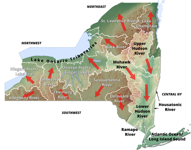
NYS flows begin at high elevation points in the Appalachians, directing snowmelt and rainfall run-off west and north into the Great Lakes/St. Lawrence River, or generally south and east, emptying into the Atlantic via Long Island Sound or further south at Chesapeake Bay.
High Flows: US Geological Survey WaterWatch, NYS as of Jul 21/21
HABS report: as of Jul 16/21 (see WTNY maps for more details)
Spills Report: as of Jul 17/21
Northeast Watersheds û empty into Lake Ontario/St. Lawrence River
Lake Champlain Watershed û
The Lake Champlain Watershed drains the area between the Adirondack Mountains in northeastern New York State and the Green Mountains in northwestern Vermont. The long, narrow and deep lake runs out the north end through the Richelieu River and empties into the Saint Lawrence River.
Includes the Ausable River, Saranac River, Great Chazy River, Boquet River, Mettawee River, Ticonderoga Creek/Lake George, Lake George, Upper Saranac Lake, Lower Saranac Lake, Lake Placid
High Flows
East Branch Ausable River at Au Sable Forks is up 1119% above mean flow, 1720 cfs
Boquet River at Willsboro up 1116%, 1650 cfs
HABs Report
Jul 12/21 Lake Champlain several large blooms have been confirmed in Clinton County
Spill Report
Clinton County: - Equipment failure in West Chazy of an unknown amount of #2 fuel oil on an impervious surface, unresolved (07/14/2021)
-Spill in Plattsburgh of unknown material in unknown amounts, no details available currently (07/12/2021)
Essex County: Currently no spills as of (07/17/2021)
Black River Watershed û
Filters and drains most of Jefferson and Lewis Counties along with parts of Herkimer, Hamilton and Oneida Counties. Major tributaries in the system include Moose River (872 miles) Beaver River (624 miles) Independence River (207 miles) and Deer River (201 miles), including Stillwater Reservoir (6195 lake/reservoir acres), Fulton Chain of Lakes (4310 acres), Lake Lila (1,414 acres) and Big Moose Lake (11,286 acres).
Contact for Black River Regulating District: (518)465-3491 or email hrao@hrbrrd.ny.gov
High Flows
Black River at Watertown is flowing 492% above mean, 9250 cfs
HABs û none reported
Spills Report
Jefferson County: Currently no spills as of (07/17/2021)
Lewis County: Currently no spills as of (07/17/2021)
St. Lawrence River Watershed -
185 km of the St. Lawrence River catching the runoff from the northern and western Adirondack Mountains, drawing from portions of eight states, a combined area of 5600 square miles.
St. Lawrence Watershed collects the flow from eleven thousand miles of freshwater rivers and streams, including the main lines: Oswegatchie River (3,590 river/stream miles), Raquette River (2,016 miles), Saint Regis River (1,734 miles), Grass River (1,607 miles) and Indian River (1,222 miles, included within the Oswegatchie sub-region watershed).
Densely forested woodlands, peatlands and areas of flat agricultural plains make up the natural surface water filtration system of this watershed area.
High Flows
Oswegatchie River near Heuvelton is up 395% to 2820 cfs
HABs
July 7/21 Black Lake, confirmed open water algal bloom in St. Lawrence County
Spill Report
Franklin County: no new spills as of Jul 12/21 to Jul 17/21
St. Lawrence County:
- Equipment failure in Canton resulted in a spill of 0.5 gallons of hydraulic oil on soil on 07/13/2021, resolved on 07/16/2021
- Equipment failure in Harrisville of an unknown amount of gasoline on an impervious surface, unresolved (07/14/2021)
- Equipment failure in Waddington of an unknown amount of manure into surface water, resolved on (07/14/2021)
- Human Error at Cranberry Lake resulted in 70 gallons of #2 fuel oil on an impervious surface, unresolved (07/12/2021)
- Equipment Failure in Norfolk of unknown amount of kerosene on an unknown resource, unresolved (07/16/2021)
Northwest Watersheds û drain to the Great Lakes and St. Lawrence River
Lake Ontario and Minor Tributaries
This watershed includes the areas between the larger rivers that drain into Lake Ontario. It is divided into western, central and eastern sections that stretch all along the Lake Ontario Shoreline.
Includes Salmon River Reservoir, Sodus Bay, North Pond, Irondequoit Bay, Perch Lake; Salmon River, Oak Orchard Creek, Irondequoit Creek, Sandy Creek
High Flows
Sandy Creek is flowing 1031% above mean at Adams NY, 792 cfs
HABs: none reported as of Jul 16/21
Spill Report
Jefferson County: Currently no spills as of (07/17/2021)
Orleans County: - Traffic accident in Holley caused 4 gallons of mineral oil to be spilt on soil, unresolved (07/15/2021)
Niagara River/Lake Erie Watershed
The Niagara River drains an area encompassing more than 265,000 square miles in the north central United States and south central Canada, including Tonawanda Creek, Cattaraugus Creek, Buffalo River; Attica Reservoir, Lime Lake
High Flows
Tonawanda Creek is up 1650% above mean at Rapids, NY, 1860 cfs
HABs: none reported
Spill Report
Erie County:
- Traffic accident in Cheektowaga caused unknown amounts of diesel and auto waste fluids to be spilled on soil, surface water, and another unknown resource, (07/11/2021), unresolved (07/11/2021)
- Traffic accident in West Seneca caused 40 gallons of transformer oil to be spilled on soil, (07/12/2021), unresolved (07/12/2021)
- Traffic Accident in Buffalo caused 100 gallons of transformer oil to be spilled on soil, (07/13/2021), unresolved (07/13/2021)
- Tank test failure in Lackawana of an unknown amount of gasoline on an unknown resource, (07/14/2021), unresolved (07/14/2021)
- Equipment Failure in Buffalo caused an unknown amount of diesel to be spilt on an unknown resource, (07/14/2021), unresolved (07/14/2021)
- Equipment failure in Alden caused 2 gallons of transformer oil to be spilt on soil, (07/15/2021), unresolved (07/15/2021)
- Equipment failure in Tonawanda caused 12 gallons of gasoline to be spilt on an unknown resource, (7/15/2021), resolved (07/19/2021)
- Equipment failure in Boston caused an unknown amount of transformer oil to be spilt on an unknown resource, (06/01/2021, unresolved
Niagara County:
- Equipment failure in Model City resulted in 150 gallons of leachate on an unknown resource, (07/10/2021), resolved (07/14/2021)
- Equipment failure in Niagara Falls resulted in 4000 lbs of freon in the air (07/15/2021), unresolved
- Human error in North Tonawanda caused 60 gallons of diesel to be spilt on soil, (07/16/2021), unresolved
Oswego River and Finger Lakes Watershed
Including Oneida Lake, Cayuga Lake, Seneca Lake, Keuka Lake, Canandaigua Lake; Oneida River, Clyde River, Cayuga Lake Tributaries, Seneca Lake Tributaries
High Flow: none reported
HABs
July 19/21 Cayuga Lake, twenty reports confirmed, small localized to large localized blooms in Tompkins County
Spill Report
Seneca County:
- Housekeeping in Seneca Falls caused 1lb of gasoline to be split in Utility Vault, (07/13/2021), unresolved
Onondaga County:
- Traffic Accident in Syrcause of an unknown amount of unknown petroleum on an unknown resource, (07/11/2021), unresolved
- Storm in Skaneateles caused 20 gallons of gasoline to be spilt in surface water, (07/15/2021), unresolved
- Unknown cause in Syrcause resulted in 2 gallons of hydraulic oil spilt on an impervious surface, (07/16/2021), resolved (07/19/2021)
Cayuga County:
- Currently no spills as of (07/17/2021)
Tompkins County:
- Equipment failure in Ithaca caused 6.6 lbs of refrigerant to be spilt into the air, (07/12/2021), resolved (07/12/2021)
- Equipment failure in Ithaca caused 2 gallons of gasoline to be spilt in the soil, (07/13/2021), resolved (07/14/2021)
- Equipment failure in Ithaca caused 1 gallon of hydraulic oil to be spilt in the soil (07/15/2021), unresolved
Schuyler County:
- Storm in Bradford caused an unknown amount of transformer oil on an unknown resource, (07/14/2021), unresolved
Yates County:
- Currently no spills as of (07/17/2021)
Ontario County:
- Equipment failure in Geneva caused 0.25 lbs of transformer oil on an unknown resource (07/13/2021), unresolved
- Equipment failure in Canadaigua caused an unknown amount of hydraulic oil on groundwater, (07/14/2021), unresolved
- Equipment failure in Naples caused 0.5 gallons of antifreeze to be spilt on soil, (07/14/2021), unresolved
Genesee River Watershed
Including: Conesus Lake, Silver Lake, Mount Morris Reservoir, Hemlock Lake, Honeoye Lake; Cassadaga Creek, Honeoye Creek, Oatka Creek, Black Creek
High Flows
- Black Creek at Churchville is up 1585%, 507 cfs
- Oatka Creek at Garbutt is up 911% to 657 cfs
- Conesus Creek near Lakeville is up 2102% to 368 cfs
HABs Report û Active Blooms
- Jul 18/21 Silver Lake: widespread HAB confirmed in Wyoming County
- Jul 7/21 Conesus Lake, large localized bloom confirmed, Livingston County
- Jul 8/21 Honeoye Lake, small localized bloom confirmed, Ontario County
- Jul 9/21 Conesus Lake, DOH confirms algal blooms at Conesus RV Park Beach, the extent of the bloom was not reported;
-
- Camp Stella beach, extent not reported; Vitale Park, extent not reported:
Jul 12/21 Honeoye Lake, widespread bloom reported in Ontario County
Spill Report
Livingston County:
- Currently no spills as of (07/17/2021)
Allegany County
- Traffic Accident in Almond caused 10 gallons of gasoline to be spilt on soil, (07/12/2021), unresolved
- Storm in Allen caused 3lbs of transformer oil to be spilt on soil, (07/13/2021), resolved (07/15/2021)
- Equipment Failure in Angelica caused 50 gallons of leachate to be spilt on soil, (07/16/2021), resolved (07/16/2021)
Monroe County:
- Unknown cause in Brockport of an unknown amount of unknown petroleum spilt on soil, (07/12/2021), unresolved
- Equipment failure in Rochester caused 8 gallons of hydraulic oil to be spilt on an unknown resource, (07/12/2021), resolved (07/13/2021)
- Equipment failure in Wheatland caused 15 gallons of hydraulic oil to be spilt on soil, (07/12/2021), resolved (07/13/2021)
- Equipment failure in Rochester caused 4.5 lbs of hydraulic oil to be spilt on soil (07/13/2021), unresolved
-Storm in Chruchville caused 1 gallon of transformer oil to be spilt on an unknown resource, (07/13/2021), resolved (07/15/2021)
- Unknown cause in Hilton of an unknown amount of unknown material spilt on an unknown resource, (07/14/2021), unresolved
- Equipment failure in Brighton of an unknown amount of transformer oil spilt on soil (07/15/2021), unresolved
-Human error in Hamlin caused 40 gallons of hydraulic oil to be spilt on soil, (07/16/2021), unresolved
Genesee County:
- Storm in Batavia caused 200 gallons of milk to be spilt in the soil, (07/13/2021), unresolved
- Human error in Pembrook caused 20 gallons of diesel on an unknown resource, (07/14/2021), unresolved
- Deliberate cause in Batavia of an unknown amount of unknown material on an unknown resource, (0714/2021), resolved (07/16/2021)
- Equipment failure in Pembrook of an unknown amount of diesel additive on an impervious surface, (07/14/2021), resolved (07/19/2021)
Wyoming County:
- Currently no spills as of (07/17/2021)
Southwest Watersheds
Allegheny River Watershed
Including Conewango Creek, Cassadaga Creek, Olean Creek, Great Valley Creek, French Creek, Allegheny Reservoir, Chautauqua Lake
High Flow: all flows are in the normal to low range as of Jul 21/21
HABs
- Jul 12/21 9 am Chautauqua Lake Association reports a small localized bloom, confirmed active. Four larger blooms are archived.
Spill Report
- Cattaraugus County: Jul 13/21 A transformer failure in Allegany spilled 5 gallons of mineral oil, the case was resolved and closed the same day.
- Equipment failure resulted in loss of 15 gallons of diesel fuel from a commercial vehicle in Cattaraugus, Jul 15/21 Unresolved.
Chautauqua County
- Jul 17/21 Stedman Road by RT 394 unknown substance spilled, amount and extent unknown
- Jul 17/21 Equipment failure was the cause of a spill of 10 gal of transformer oil at Ashville, RT 474
Chemung River Watershed
The Chemung River flows across the western portion of Southern Tier of New York State before joining the Susquehanna River and eventually emptying into the Chesapeake Bay.
Including Cohocton River, Tioga/Canisteo River; Lamoka Lake/Mill Pond, Waneta Lake, Almond Lake
High Flows
- Jul 21/21 Canisteo River is up 748% above mean flow, discharging 876 cfs
- Tioga River near Erwens, NY is up 932% above mean value, 4370 cfs
- Tioga River at Lindley, NY is up 1058%, discharging 2270 cfs
- Chemung River at Corning, NY is up 1118%, flowing at 7530 cfs
- Chemung River at Chemung, NY up 1252%, flowing 9020 cfs
HABs
- July 7/21 Tanglewood Lake, small localized bloom spotted in Steuben County
- July 11/21 Waneta Lake, confirmed bloom, extent not reported
Spill Report:
Chemung County
- Jul 12/21 A car accident at Elmira released 5 gallons of gasoline onto impervious surface. Record closed the following day.
Steuben County
- Jul 10/21 deliberate act at a residence in Hammondsport; burning of tires, case resolved Jul 13/21
- Jul 12/21 Commercial spill of an unknown amount of diesel fuel onto soil occurred at Prattsburg, unresolved.
- Jul 15/21 Commercial equipment failure released 10 gal muriatic acid to unknown resource on 5600 block of Turnpike Rd, Bath, NY. Record closed Jul 15/21
- Jul 15/21 Raw Sewage may have been released from a private dwelling into Cranberry Pond at Addison, NY. Record closed on Jul 19/21
Susquehanna River Watershed
The Susquehanna River drains 27,500 square miles covering large parts of New York, Pennsylvania and Maryland before emptying into the Chesapeake Bay.
Including: Chenango River, Tioughnioga River, Unadilla River, Owego Creek; Otsego Lake, Canadarago Lake, Whitney Point Lake/Reservoir
High Flow û as of Jul 21/21
Susquehanna River near Waverly, NY is up 944% above mean flow at 22,100 cfs
- At Vestal NY up 1034%, 21000 cfs
- At Conklin, NY up 849%, 10,200 cfs
- At Unadilla, NY up 1042%, 4610 cfs
- Unadilla River is flowing 1711% over mean, at 4520 cfs
- Oueleout Creek at East Sidney is up 1004% at 547 cfs
HABs û no HABs as of Jul 20/21
Spill Report:
Broome County
- Jul 12/21 900 block Pazelli Road, Stanford, equipment failure caused 5 gallons diesel fuel to spill to soil. Record closed Jul 13/21
- Jul 13/21 equipment failure at Endicott caused loss of 25 gallons of gas to an unknown resource, unresolved.
- Jul 16/21 a private dwelling in Conklin reports spill of unknown amount of contaminant ôotherö to soil, record closed Jul 19/21
Chenango County
- Jul 15/21 unknown amount of petroleum product spilled at a private dwelling in Sherburne, unresolved
- Cortland County - No spills reported for the period of Jul 12 - 17
- Otsego County Jul 14/21 equipment failure in Chenevus resulted in 2 gal hydraulic oil spilling to unknown resource, unresolved.
- Tioga County û no spills reported this week
Central NY Watersheds
Mohawk River Watershed
The Mohawk River originates in the western Adirondacks and the Tug Hill Plateau and flows 140 miles to the east where it joins the Hudson River. Sections of the Mohawk River also serve as the New York State Barge (Erie) Canal.
Including Schoharie Creek, West Canada Creek, East Canada Creek; Hinkley Reservoir, Delta Reservoir, Peck Lake, Schoharie Reservoir (1,132 acres)
High Flows: US Geological Survey WaterWatch, NYS as of Jul 21/21
- Jul 21/21 Mohawk River below Delta Dam at Rome, NY is flowing at 608% above mean value.
- Jul 21/21 Mohawk River near Little Falls, NY up 513% above mean value.
Schoharie Creek is up 5042% above mean flow rate,
HABs û no HABs as of Jul 20/21
Spill Report
Montgomery County
- Jul 12/21 unknown petroleum discharged into sewer system at Fonda, record closed Jul 14/21
- Jul 12/21 unknown amount of gasoline spilled into Erie Canal at Tribes Hill, closed same day.
- Jul 15/21 a gas station in Fonda reported spill of unknown amount of gas, unresolved
Schoharie County
- Jul 14/21 5 gallons of #2 fuel oil spilled at a private residence in Carlisle, record closed Jul 19/21
Upper Hudson River Watershed
The Upper Hudson River Watershed drains the south side of the Adirondack Mountains and flows south to meet the Mohawk River.
Including Sacandaga River, Schroon River, Fish Creek, Hoosic River, Batten Kill, Great Sacandaga Lake, Indian Lake, Schroon Lake, Saratoga Lake
High Flows:
Hudson River at Hadley NY up 692%, 9420 cfs
- At North Creek up 586%, 4770 cfs
- At Fort Edward up 288%, 9270 cfs
- At Green Island up 579%, 38,500 cfs
HABs û no HABs as of Jul 20/21
Spill Report
Saratoga County
- Jul 12/21 unknown amount of hydraulic oil spilled to soil at Clifton Park, record closed Jul 16/21
- Jul 12/21 raw sewage spilled to soil and surface water at Mechanicsville, record closed Jul 16/21
- Jul 13/21 50 gallons of gas spilled to soil and sewer from a shop in Schuylerville, unresolved
- Jul 13/21 residential spill of an unknown amount of petroleum affecting soil at Halfmoon, record closed Jul 16/21
- Jul 17/21 commercial spill of 10 gallons of hydraulic oil occurred at Ballston Spa, unresolved
Washington County
- Jul 12/21 equipment failure caused release of 55 gal methanol to soil in Greenwich, record closed Jul 16/21
Warren County
- Jul 13/21 Equipment failure at a residence in Warrensburg released an unknown amount of #2 fuel oil to the soil, unresolved
- Jul 16/21 human error caused lube oil to spill into Lake George, unresolved
Lower Hudson River Watershed
The Lower Hudson Watershed begins where the Mohawk River joins the Hudson system at the Troy Dam and extends down to Manhattan. The lower end of the Hudson system, 153 miles, is technically a tidal estuary, not a river.
Rondout/Wallkill Rivers, Stockport/Kinderhook Creeks, Catskill Creek, Esopus Creek, Croton River; Ashokan Reservoir, Rondout Reservoir, New Croton Reservoir, Alcove Reservoir, Cross River Reservoir, Muscoot/Upper New Croton Reservoir
High Flows:
Kinderhook Creek is up 1331% at Rossman, 2350 cfs
Esopus Creek at Mount Marion is up 1068%, 1340 cfs
HABs
- Jul 10/21 Kinderhook Lake, open water bloom confirmed in Columbia County
- Jul 10/21 Lake Waccabuc, widespread bloom and small localized bloom confirmed in Westchester
- Jul 11/21 Kirk Lake, open water bloom confirmed in Putnam County
- Jul 12/21 Lake Carmel, small localized bloom confirmed in Putnam County
- Jul 12/21 Putnam Lake, large localized bloom confirmed by DOH in Putnam County
- Jul 13/21 Lake Casse, large localized bloom confirmed in Putnam County
- Jul 14/21 Lake Peekskill, two large localized blooms confirmed in Putnam County
- Jul 14/21 Oscawana Lake, 2 large localized and 1 small localized bloom confirmed, Putnam County
- Jul 14/21 Putnam Lake, small localized bloom confirmed by DOH, Putnam County
- Jul 15/21 Lake Taghkanic, large localized bloom confirmed in Columbia County
- Jul 18/21 Chrysler Pond, DEC confirms a bloom of unknown extent in Columbia County
Delaware River Watershed
The headwaters flow down from the Catskill Mountains into Delaware Bay/Atlantic Ocean. The watershed area includes East Branch Delaware River, West Branch Delaware River, Neversink River, Mongaup River, Pepacton Reservoir, Cannonsville Reservoir and Neversink Reservoir
High Flow:
East Branch Delaware at Fishs Eddy up 768%
- At Harvard, up 1013%, 2450 cfs
- At Downsville, up 727%
West Branch Delaware River at Hale Eddy is up 685%, 4160 cfs
- At Walton, up 1415% at 2520 cfs
- Upstream from Delhi up 1436%, 978 cfs
Little Delaware River near Delhi is up 969%, 340 cfs
Delaware River at Calicoon is up 527%, 7010 cfs
- Above Lackawaxen River near Barrywell is up 539% to 7610 cfs
- At Port Jervis up 433% to 10,400 cfs
Neversink River at Neversink is up 657% to 529 cfs
HABS
July 11/21 Mountain Lake, confirmed open water algal bloom in Sullivan County
Spill Report:
Sullivan County
- Jul 12/21 a traffic accident resulted in a spill of 25 gallons of diesel at Wurtsboro, record closed Jul 13/21
- Jul 14/21 unknown amount of gas spilled at gas station in Parksville, unresolved
- Jul 15/21 equipment failure caused spill of #2 fuel oil to the soil at a residence in Liberty, unresolved
- Jul 16/21 deliberate dumping of 5lbs waste oil to the soil occurred in Wurtsboro, unresolved
Delaware County
- Jul 12/21 a turbid discharge of unknown amount from a private dwelling into surface water at Davenport, report closed on Jul 12/21
- Jul 13/21 a commercial/industrial equipment failture caused an unknown amount of diesel spilled on soil at Bloomville, unresolved
- Jul 15/21 an unknown amount of gas was spilled into surface water in a roadside ditch at Walton, unresolved.
Housatonic River Watershed
A small portion of the headwaters of the Housatonic lie in eastern New York State. These waters drain the Taconic and Berkshire Mountains before joining the Housatonic and eventually emptying into Long Island Sound. Includes Tenmile River, Green River, Indian Lake, Swift/Crane Ponds
High Flow: none reported
HABs : no blooms reported as of Jul 20/21
Ramapo River Watershed
The northern headwaters of the Passaic basin lie within a small portion of southeastern New York State, including the Ramapo and Hackensack Rivers drainage areas. It is the smallest watershed in New York State. Including Ramapo River, Hackensack River, Greenwood Lake, DeForest Lake
High Flow: all flows normal
HABs û no blooms reported as of Jul 20/21
Spill Report
Rockland County
- Jul 12/21 transformer failure at Yapank released 5 lbs of transformer oil to the soil, unresolved
- Jul 15/21 unknown amount of #2 fuel oil was dumped on soil at Tompkins Cove by equipment failure at a private dwelling, unresolved
- Jul 16/21 15 gallons of transformer oil spilled on soil at Suffern, record closed Jul 19/21
- Jul 17/21 8 gallons of gas spilled due to traffic incident in Orangetown, record closed Jul 19/21
Orange County
- Jul 12/21 a storm caused a spill of unknown amount of contaminant at New Windsor, unresolved
- Jul 13/21 equipment failure caused a spill of unknown amount of #2 fuel oil at Highland Falls, unresolved
- Jul 14/21 deliberate release of an unidentified contaminant occurred at Campbell Hall
- Jul 14/21 transformer oil spill at Pine Bush, record closed July 15/21
- Jul 15/21 a leaking drum caused an unknown amount of petroleum to spill at Walkill, unresolved
- Jul 15/21 2 gallons of transformer oil spilled on soil at Middle Town, unresolved
- Jul 16/21 equipment failure caused unknown amount of diesel to spill to soil at Otisville, unresolved
- Jul 17/21 a quarter lb of transformer oil spilled at Middle Town, record closed Jul 19
Atlantic Ocean/Long Island Sound Watershed
The Atlantic Ocean/Long Island Sound Watershed drains most of the New York City Metropolitan Area and all of Long Island. The drainage area includes all marine waters in New York Harbor, Long Island Sound, Block Island Sound, and along the South Shore of Long Island, and the fresh waters that drain into them.
Includes 1415 square miles of marine estuary waters, the Bronx River, Mamaroneck River, Mianus River, Peconic River, Kensico Reservoir, Lake Ronkonkoma
High Flow: flows normal or below normal
HABs
- Jul 12/21 Maratooka Lake, algal bloom confirmed, extent not reported in Suffolk County
- Jul 13/21 Mill Pond (Watermill) widespread bloom confirmed in Suffolk County
- Jul 13/21 Wainscott Pond, widespread bloom confirmed in Suffolk County
- Jul 14/21 Agawam Lake, widespread bloom confirmed in Suffolk County
- Jul 15/21 Prospect Park Lake, two widespread blooms confirmed in Brooklyn
|
|
All rights reserved 2026 - WTNY - This material may not be reproduced in whole or in part and may not be distributed,
publicly performed, proxy cached or otherwise used, except with express permission.
|
|