2021/9/29
Watershed Report
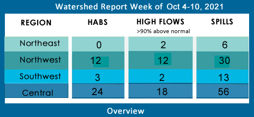
With the Flow – New York State Watershed Report for the Week of Oct 4-10
Number of new HABS blooms are decreasing this week
By Gillian Ward
OVERVIEW
SEE BELOW FOR DETAILS
Report Key:
High Flows: WTNY reports systems flowing more than 90% over mean flow rate, categorized as “much above normal” and “high”, based on USGS WaterWatch real time streamflow
Visit USGS WaterWatch for real time stream flows.
See also, National Weather Service high water terminology here https://www.weather.gov/aprfc/terminology
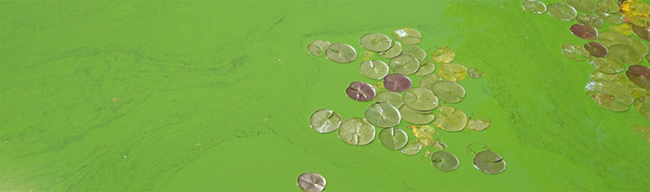
HABs – reporting confirmed hazardous algal blooms (cyanobacteria) confirmed as active on NYS HABs Notifications
Spills Report– hazardous materials spill incidents by county, listed in the pertinent watershed, as appearing in the NYS Environmental Sites Database, Spill Incidents Database as records are uploaded
See Watershed Basics Glossary for details on each report.
Central NY Watersheds emptying into Atlantic Ocean at Long Island Sound
Mohawk River Watershed
The Mohawk River originates in the western Adirondacks and the Tug Hill Plateau and flows 140 miles to the east where it joins the Hudson River. Sections of the Mohawk River also serve as the New York State Barge (Erie) Canal.
Including Schoharie Creek, West Canada Creek, East Canada Creek; Hinkley Reservoir, Delta Reservoir, Peck Lake, Schoharie Reservoir; joins the Hudson River below Albany.
High Flows:
- East Canada Creek is flowing much above normal at East Creek this week, 208% above mean, 738 cfs
- Otsquago Creek at Fort Plain is rising as we write this, flowing 324% above mean, at 85.7 cfs as of Oct 4 at noon EDT
- Schoharie Creek at Burtonsville is flowing high, 1443% above mean, 4500 cfs; at Breakabeen 465% above mean, 1090 cfs
- Mine Kill near North Blenheim is flowing much above normal, 452% above mean at 46 cfs
HABs: none reported
Spill Report
Montgomery County:
-Equipment failure in Amsterdam caused unknown amounts of diesel to be spilled in the soil 09/27/21, unresolved
-Tank Test Failure in Fonda caused unknown amounts of gasoline to be spilled on an unknown resource 09/28/21, unresolved
Schoharie County:
-Equipment failure in Richmondville caused 0.5 gallons of transformer oil to be spilled in the soil 09/25/21, unresolved
Upper Hudson River Watershed
The Upper Hudson River Watershed drains the south side of the Adirondack Mountains and flows south.
Including Sacandaga River, Schroon River, Indian River, Fish Creek, Hoosic River, Batten Kill, Great Sacandaga Lake, Indian Lake, Schroon Lake, Saratoga Lake
High Flows –
- Hudson River above Lock 1 at Waterford is much above normal, 189% above mean at 9060 cfs
- Glowegee Creek is flowing high this week, 728% above mean, 100 cfs
- Hoosic River near Eagle Bridge is flowing much above normal, 299% above mean, 1560 cfs
- Sacandaga River is flowing much above normal at Stewart’s Bridge near Hadley, 209% above mean at 3970 cfs
HABs
- Sep 28 Moreau Lake small localized bloom confirmed in Saratoga County
Spill Report
Saratoga County:
-Traffic accident in Wilton caused 17 gallons of transformer oil to be spilled in the soil 09/26/21, unresolved
-Equipment failure in Selkirk caused 30 gallons of lube oil to be spilled in the soil 09/27/21, unresolved
-Unknown cause in Balston spa caused unknown amounts of gasoline to be spilled in the soil 09/28/21, unresolved
-Equipment failure in Clifton Park caused 2 gallons of transformer oil to be spilled on an unknown resource 09/29/21, unresolved
Washington County:
-Equipment failure in Hudson falls caused 10 gallons of hydraulic oil to be spilled on an unknown resource 09/29/21, unresolved
Warren County: none reported
Lower Hudson River Watershed
The Lower Hudson Watershed begins where the Mohawk River joins the Hudson system at the Troy Dam and extends down to Manhattan. The lower end of the Hudson system, 153 miles, is technically a tidal estuary, not a river.
Rondout/Wallkill Rivers, Stockport/Kinderhook Creeks, Catskill Creek, Esopus Creek, Croton River; Ashokan Reservoir, Rondout Reservoir, New Croton Reservoir, Alcove Reservoir, Cross River Reservoir, Muscoot/Upper New Croton Reservoir
High Flows:
- Valatie Kill near Nassau is flowing high this week, 1026% above mean at 55 cfs
- Kinderhook Creek at Rossman has slowed this week, but still flowing much above normal, 338% above mean at 657 cfs
- Esopus Creek at Mount Marion is flowing much above normal, 385% above mean to 1200 cfs
HABs
Sep 25 Lawson Lake widespread/lakewide bloom confirmed in Albany County (as shown above)
Sep 29 Roaring Brook Lake small localized bloom confirmed in Putnam County, another small localized bloom reported Sep 21 remains active
Sep 21 Lake Mohegan open water bloom confirmed in Westchester County
Tomkins Lake small localized bloom confirmed in Rockland County Sep 20 remains active
Spill Report
Westchester County:
-Equipment failure in Yonkers caused 255 gallons of dielectric fluid to be spilled on an unknown resource 09/25/21, unresolved
-Human error in Ossining caused 4 gallons of #2 fuel oil to be spilled on an unknown resource 09/25/21, unresolved
-Unknown cause in Port Chester caused unknown amounts of unknown petroleum to be spilled in the soil and groundwater 09/26/21, unresolved
-Equipment failure in Cortlandt caused unknown amounts of hydraulic oil to be spilled on an unknown resource 09/27/21, resolved 09/27/21
-Equipment failure in Cortlandt caused unknown amounts of hydraulic oil to be spilled on an unknown resource 09/27/21, resolved 09/27/21
-Unknown cause in Cortlandt caused 25 gallons of hydraulic oil to be spilled on an unknown resource 09/27/21, resolved 09/29/21
Orange County:
-Human error in Montgomery caused 1 gallon of other material to be spilled on an unknown resource 09/25/21, resolved 09/27/21
-Equipment failure in Washingtonville caused unknown amounts of #2 fuel oil to be spilled on an unknown resource 09/25/21, unresolved
-Equipment failure in Middletown caused unknown amounts of #2 fuel oil to be spilled in the soil 09/25/21, unresolved
-Equipment failure in Pine Island caused 1 gallon of transformer oil to be spilled on an unknown resource 09/26/21, resolved 09/27/21
-Equipment failure in Monroe caused 3 gallons of non PCB oil to be spilled on an unknown resource 09/27/21, resolved 09/27/21
-Equipment failure in New Windsor caused unknown amounts of #2 fuel oil to be spilled in the soil 09/28/21, unresolved
Putnam County: None reported
Columbia County: None reported
Delaware River Watershed
The headwaters flow down from the Catskill Mountains into Delaware Bay/Atlantic Ocean. The watershed area includes East Branch Delaware River, West Branch Delaware River, Neversink River, Mongaup River, Pepacton Reservoir, Cannonsville Reservoir and Neversink Reservoir.
High Flows:
- West Branch Delaware at Stilesville is flowing much above normal, 217% above mean at 1410 cfs, at Hale Eddy is still flowing much above normal, 224% above mean, 1710 cfs;
- East Branch Delaware at Downsville 333% above mean, 684 cfs; at Harvard 270% above mean, 835 cfs;
- Neversink River at Neversink is flowing much above normal 288% above mean at 188 cfs
- Beaver Kill at Cook’s Falls is flowing 303% above mean at 965 cfs
- Calicoon Creek at Callicoon is flowing much above normal this week, 528% above mean to 412 cfs
HABS:
Sep 25 Rio Reservoir small localized bloom confirmed in Sullivan County
Spill Report:
Sullivan County:
-Equipment failure in Forestburg caused unknown amounts of #2 fuel oil to be spilled in the soil 09/28/21, unresolved
-Equipment failure in Callicoon caused unknown amounts of #2 fuel oil to be spilled in the soil 10/01/21, unresolved
Delaware County:
-Other cause in Margetville caused unknown amounts of diesel to be spilled on an unknown resource 09/29/21, unresolved
Ulster County:
-Equipment failure in Saugerties caused unknown amounts of #2 fuel oil to be spilled on an unknown resource 09/29/21, unresolved
Housatonic River Watershed
A small portion of the headwaters of the Housatonic lie in eastern New York State. These waters drain the Taconic and Berkshire Mountains before joining the Housatonic and eventually emptying into Long Island Sound. Includes Tenmile River, Green River, Indian Lake, Swift/Crane Ponds
High Flow:
Housatonic and Green Rivers are flowing much above normal as noted in monitoring stations at Great Barrington, Vermont
All New York monitoring stations in Housatonic Watershed are below 90th percentile flows.
HABs: none reported
Spill Report:
Dutchess County:
-Equipment failure in Pine Plains caused unknown amounts of hydraulic oil to be spilled on an unknown resource 09/25/21, resolved 09/26/21
-Equipment failure in Poughkeepsie caused 10 gallons of gasoline to be spilled on an unknown resource 09/27/21, resolved 09/27/21
-Equipment failure in Hopewell Junction caused unknown amounts of #2 fuel oil to be spilled in the soil 09/27/21, unresolved
-Equipment failure in Holmes caused unknown amounts of #2 fuel oil to be spilled in the soil 09/30/21, unresolved
Ramapo River Watershed
The northern headwaters of the Passaic basin lie within a small portion of southeastern New York State, including the Ramapo and Hackensack Rivers drainage areas. It is the smallest watershed in New York State. Including Ramapo River, Hackensack River, Greenwood Lake, DeForest Lake.
High Flow: all flows below 90th percentile
HABs: none reported
Spills Report:
Rockland County:
-Traffic accident in Congers caused unknown amounts of transformer oil to be spilled on an unknown resource 09/25/21, resolved 09/26/21
-Equipment failure in New City caused 1 gallon of transformer oil to be spilled in the soil 09/26/21, resolved 09/27/21
-Equipment failure in Orangeburg caused 1 gallon of transformer oil to be spilled in the soil 09/27/21, resolved 09/27/21
-Equipment failure in Suffern caused 10 gallons of diesel to be spilled on an unknown resource 09/29/21, resolved 09/29/21
-Tank Test Failure in Spring Valley caused unknown amounts of other material to be spilled on an unknown resource 09/30/21, unresolved
Atlantic Ocean/Long Island Sound Watershed
The Atlantic Ocean/Long Island Sound Watershed drains most of the New York City Metropolitan Area and all of Long Island. The drainage area includes all marine waters in New York Harbor, Long Island Sound, Block Island Sound, and along the South Shore of Long Island, and the fresh waters that drain into them.
Includes 1415 square miles of marine estuary waters, the Bronx River, Mamaroneck River, Mianus River, Peconic River, Kensico Reservoir, Lake Ronkonkoma.
High Flow:
- Mill Neck Creek at Mill Neck is flowing much above normal this week, 138% above mean, 11 cfs
- Sampawams Creek at Babylon is flowing much above normal this week, 187% above mean flow at 12 cfs
HABs –
Sept 30 Morningside Pond large localized bloom confirmed in Manhattan
Sep 30 Prospect Park Lake widespread/lakewide bloom confirmed in Kings County; the widespread bloom reported Sep 24 remains active
Sep 30 Agawam Lake widespread bloom confirmed in Suffolk County, the widespread bloom confirmed Sep 20 remains active
Sep 30 Mill Pond (Watermill) widespread/lakewide bloom confirmed in Suffolk County, the widespread bloom confirmed Sep 20 in Suffolk County
Sep 30 Wainscott Pond lakewide/widespread bloom confirmed in Suffolk County; the lakewide bloom confirmed Sept 20 remains active
Sep 28, 29, 30 Georgica Pond large localized, small localized and extent unknown blooms confirmed in Suffolk County; one unspecified extent bloom confirmed in Suffolk County Sep 20 remains active
Turtle Pond widespread/lakewide bloom confirmed in Manhattan Sep 24 remains active
The Lake In Central Park widespread bloom confirmed in Manhattan Sep 23 remains active
Kissena Lake widespread/lakewide bloom confirmed Sep 23 in Queens County remains active
Goose Pond widespread/lakewide bloom confirmed in Queens County Sep 23 remains active
Spill Report:
Kings (Brooklyn):
-Equipment failure in Brooklyn caused unknown amounts of Bilge oils to be spilled in the surface water 09/29/21, resolved 09/29/21
-Abandoned drums in Brooklyn caused unknown amounts of motor oil to be spilled on an unknown resource 09/29/21, unresolved
-Unknown cause in Brooklyn caused unknown amounts of #2 fuel oil to be spilled in the soil 09/30/21, unresolved
-Equipment failure in Brooklyn caused unknown amounts of Engine oil to be spilled on an unknown resource 09/30/21, unresolved
-Equipment failure in Brooklyn caused unknown amounts of gasoline to be spilled in the soil and groundwater 10/01/21, unresolved
Queens County:
-Equipment failure in Queens caused unknown amounts of gasoline to be spilled on an unknown resource 09/27/21, unresolved 09/27/21
-Traffic accident in Queens caused 40 gallons of diesel to be spilled on an unknown resource 09/27/21, unresolved
-Abandoned drums in Queens caused unknown amounts of diesel to be spilled on an unknown resource 09/27/21, unresolved
-Traffic accident in Queens caused unknown amounts of diesel to be spilled on an unknown resource 09/27/21, resolved 09/27/21
-Equipment failure in Fresh Meadows caused 1 gallon of #2 fuel oil to be spilled on an unknown resource 09/27/21, resolved 09/28/21
Nassau County:
-Equipment failure in Oceanside caused unknown amounts of #2 fuel oil to be spilled in the soil 09/26/21, unresolved
-Equipment failure in Levittown caused unknown amounts of #2 fuel oil to be spilled in the soil 09/27/21, unresolved
-Abandoned drums in Hempstead caused 715 gallons of cooking grease to be spilled in the surface water and sewer 09/27/21, unresolved
-Equipment failure in Woodbury caused unknown amounts of #2 fuel oil to be spilled in the soil 09/27/21, unresolved
-Equipment failure in Farmingdale caused 3 gallons of #2 fuel oil to be spilled on an unknown resource 09/27/21, resolved 09/27/21
-Equipment failure in Freeport caused unknown amounts of #2 fuel oil to be spilled in the soil 09/28/21, unresolved
-Equipment failure in Massapequa caused 6 gallons of #2 fuel oil to be spilled on an impervious surface 09/28/21, unresolved
Suffolk County:
-Equipment failure in Port Jefferson Station caused 3 gallons of #2 fuel oil to be spilled on an impervious surface 09/26/21, resolved 09/27/21
-Unknown cause in Copiague caused 15 gallons of unknown petroleum to be spilled in the surface water 09/27/21, unresolved
Richmond County:
-Equipment failure in Staten Island caused unknown amounts of unknown petroleum to be spilled in the sewer 09/27/21, resolved 09/28/21
-Equipment failure in Staten Island caused unknown amounts of transformer oil to be spilled in the soil 09/28/21, unresolved
-Equipment failure in Staten Island caused unknown amounts of #2 fuel oil to be spilled in the soil 10/01/21, unresolved
Bronx County: None reported
Northeast Watersheds– emptying into Atlantic Ocean via St. Lawrence River
Lake Champlain Watershed
The Lake Champlain Watershed drains the area between the Adirondack Mountains in northeastern New York State and the Green Mountains in northwestern Vermont.
Includes the Ausable River, Saranac River, Great Chazy River, Boquet River, Mettawee River, Ticonderoga Creek/Lake George, Lake George,
Upper Saranac Lake, Lower Saranac Lake, Lake Placid, Lake Champlain
High Flows:
- Great Chazy River at Perry Mills is flowing much above normal this week, 140% above mean, 146 cfs
HABs: none reported
Spill Report:
Clinton County:
-Equipment failure in Plattsburgh caused 1 gallon of antifreeze to be spilled on an unknown resource 09/30/21, unresolved
Essex County:
-Unknown cause in Lake Placid caused unknown amounts of unknown material to be spilled in the surface water 09/29/21, unresolved
St. Lawrence River Watershed
185 km of the St. Lawrence River catches the runoff from the northern and western Adirondack Mountains, drawing from portions of eight states, a combined area of 5600 square miles.
St. Lawrence Watershed collects the flow from eleven thousand miles of freshwater rivers and streams, including the Oswegatchie River, Raquette River, Saint Regis River, Grass River and Indian River; including Black Lake, Cranberry Lake, Raquette Lake, Tupper Lake and Long Lake. Densely forested woodlands, peatlands and areas of flat agricultural plains make up the natural surface water filtration system of this watershed area.
High Flows:
Raquette River at South Colton is flowing much above normal, 223% above mean at 2930 cfs
HAB’s
Black Lake Large localized bloom and extent unreported bloom confirmed Sep 16,17 in St. Lawrence County remain active this week
Spill Report
Franklin County: none reported
St. Lawrence County:
-Traffic accident in Hammond caused 3 gallons of gasoline to be spilled in the surface water 09/27/21, resolved 09/30/21
-Equipment failure in Massena caused 200 gallons of #2 fuel oil to be spilled in the soil 09/29/21, unresolved
Black River Watershed
Filters and drains most of Jefferson and Lewis Counties along with parts of Herkimer, Hamilton and Oneida Counties.
Major tributaries in the system include Moose River, Beaver River, Independence River and Deer River, Stillwater Reservoir, Fulton Chain of Lakes, Lake Lila and Big Moose Lake.
High Flows: all flows below 90th percentile
HABs – none reported
Spill Report :
Jefferson County:
-Equipment failure in Le Ray caused 80 gallons of hydraulic oil to be spilled in the soil 09/28/21, unresolved
-Equipment failure in Le Ray caused 0.25 gallons of mineral oil to be spilled in the soil 09/29/21, unresolved
Lewis County: none reported
Northwest Watersheds – empty into Atlantic Ocean via Great Lakes and St. Lawrence River
Lake Ontario and Minor Tributaries
This watershed includes the areas between the larger rivers that drain into Lake Ontario. It is divided into western, central and eastern sections that stretch all along the Lake Ontario Shoreline.
*Includes Salmon River Reservoir, Sodus Bay, North Pond, Irondequoit Bay and Perch Lake; Salmon River, Oak Orchard Creek, Irondequoit Creek, Sandy Creek
High Flows: all systems below 90th percentile
HABs:
Sep 28 Lake Neatahwanta widespread/lakewide bloom confirmed Sep 14 in Fulton County remain active this week
Spill Report
Orleans County: None reported
Wayne County:
-Other cause in Macedon caused unknown amounts of unknown material to be spilled on an unknown resource 09/29/21, resolved 10/04/21
-Deliberate act in Macedon caused unknown amounts of waste fluids to be spilled on an unknown resource 09/30/21, resolved 10/04/21
Oswego County:
-Other cause in Oswego caused unknown amounts of unknown petroleum to be spilled on an unknown resource 09/28/21, unresolved
-Unknown cause in Oswego caused unknown amounts of unknown petroleum to be spilled on an unknown resource 09/28/21, unresolved
Niagara River/Lake Erie Watershed
The Niagara River drains an area encompassing more than 265,000 square miles in the north central United States and south central Canada, including Tonawanda Creek, Cattaraugus Creek, Buffalo River; Attica Reservoir and Lime Lake.
High Flows:
- Ellicott Creek below Williamsville is flowing much above normal, 624% above mean at 471 cfs
- Cayuga Creek near Lancaster is flowing much above normal, 1200% above mean, 704 cfs
- Buffalo Creek at Gardenville is flowing much above normal, 863% above mean flow, 823 cfs
- Cazenovia Creek at Ebeneezer is flowing much above normal, 504% above mean, 631
- Tonawanda Creek at Attica is flowing much above normal, 539% above mean, 390 cfs; at Batavia much above normal flows this week, 753% above mean, 681 cfs
HABs:
Sep 29 Ellicott Creek large localized bloom confirmed in Erie County
Spill Report
Erie County:
-Equipment failure in Buffalo caused 5 gallons of hydraulic oil to be spilled on an unknown resource 09/27/21, resolved 09/28/21
-Traffic accident in Buffalo caused unknown amounts of transformer oil to be spilled on an unknown resource 09/27/21, unresolved
-Storm in Marilla caused 10 gallons of transformer oil to be spilled on an unknown resource 09/27/21, unresolved
-Equipment failure in Buffalo caused unknown amounts of mineral oil to be spilled in the soil 09/30/21, resolved 09/30/21
-Unknown cause in Buffalo caused unknown amounts of unknown material to be spilled in the soil 09/30/21, resolved 09/30/21
-Human error in Buffalo caused 6 gallons of gasoline to be spilled on an unknown resource 10/01/21, resolved 10/01/21
Niagara County:
-Equipment failure in Niagara Falls caused 50 gallons of sodium chloride to be spilled in the soil and surface water 09/26/21, unresolved
-Equipment failure in Barker caused 10 gallons of transformer oil to be spilled in the soil 09/28/21, unresolved
Genesee River Watershed
Including: Conesus Lake, Silver Lake, Mount Morris Reservoir, Hemlock Lake, Honeoye Lake; Cassadaga Creek, Honeoye Creek, Oatka Creek, Black Creek
High Flows:
- Oatka Creek is flowing high this week, 1347% above mean, 338 cfs
- Black Creek at Churchville is flowing much above normal, 307% above normal, 141 cfs
- Northrup Creek at North Greece is flowing high, 493% above mean at 43 cfs
- Conesus Creek near Lakeville is flowing much above normal, 229% above mean, 35.5 cfs
- Honeoye Creek at Honeoye Falls is flowing high, 3540 % above mean at 1410 cfs
HABs:
Sep 23, 25, 29 Canandaigua Lake large localized, small localized bloom and another small localized bloom confirmed in Ontario County
Sep 27, 28 Honeoye Lake two large localized blooms and one small localized bloom confirmed in Ontario County
Spill Report:
Livingston County:
-Equipment failure in Leicester caused 5 gallons of hydraulic oil to be spilled on an unknown resource 09/27/21, unresolved
Allegany County: None reported
Monroe County:
-Equipment failure in Henrietta caused 12 gallons of hydraulic oil to be spilled in the soil and impervious surface 09/27/21, resolved 09/28/21
-Equipment failure in Rochester caused 70 gallons of other material to be spilled in the soil and sewer 09/28/21, resolved 09/29/21
-Unknown cause in Pittsford caused unknown amounts of diesel to be spilled in the soil 09/29/21, unresolved
Genesee County:
-Equipment failure in East Pembroke caused unknown amounts of other material to be spilled on an unknown resource 09/29/21, unresolved
-Equipment failure in Elba caused unknown amounts of diesel to be spilled on an unknown resource 10/01/21, unresolved
Wyoming County: none reported
Oswego River and Finger Lakes Watershed
Including Otisco, Skaneateles, Owasco, Cayuga, Oneida, Seneca, Keuka, Canandaigua and Canadice Lakes; Oneida River, Clyde River, Cayuga Lake Tributaries and Seneca Lake Tributaries
High Flow:
- Flint Creek at Phelps is flowing much above normal this week, 890% above mean at 249 cfs
- Canadaigua Outlet at Chapin is still flowing over the 90th percentile, 690% above mean, 509 cfs
- Onandaga Creek at Spencer St Syracuse is flowing much above normal, 230% above mean at 236 cfs
- Fall Creek near Ithaca is flowing much above normal, 691% above mean, 533 cfs
HABs: 3 Active Blooms Remaining
Cayuga Lake:
- North end of the lake, large localized bloom reported Sep 20, another large localized bloom reported Sep 28, and a small localized bloom confirmed in Cayuga County Sep 29
Spill Report:
Seneca County:
-Traffic accident in Romulus caused 125 gallons of diesel to be spilled in the soil and surface water 09/28/21, unresolved
-Equipment failure caused 40 gallons of transformer oil to be spilled on an impervious surface 10/01/21, resolved 10/04/21
Onondaga County:
-Human error in Liverpool caused 10 gallons of gasoline to be spilled on an unknown resource 09/25/21, resolved 09/27/21
-Equipment failure in Skaneateles Falls caused unknown amounts of hydraulic oil to be spilled on an unknown resource 09/28/21, resolved 09/29/21
-Traffic accident in Syracuse caused 20 gallons of diesel and hydraulic oil to be spilled on an unknown resource 09/28/21, unresolved
-Equipment failure in Syracuse caused unknown amounts of kerosene to be spilled in the soil 09/29/21, unresolved
-unknown cause in Syracuse caused unknown amounts of unknown petroleum to be spilled in the soil 09/30/21, unresolved
-Unknown cause in Marcelus caused unknown amounts of hydraulic oil to be spilled in the soil 09/30/21, unresolved
-Other cause in Syracuse caused unknown amounts of gasoline to be spilled in the groundwater 10/01/21, unresolved
Schuyler County: none reported
Yates County:
-Unknown cause in Penn Yan caused unknown amounts of raw sewage to be spilled in the soil and groundwater 09/25/21, unresolved
Ontario County:
-Equipment failure in Farmington caused 20 gallons of gasoline to be spilled in the soil 09/27/21, unresolved
-Traffic accident in Geneva caused 15 gallons of diesel to be spilled on an unknown resource 09/27/21, unresolved
Southwest Watersheds – Allegheny, emptying into Gulf of Mexico via Ohio River/Mississippi River; Chemung and Susquehanna emptying into Atlantic Ocean via Chesapeake Bay
Allegheny River Watershed (flowing west into Ohio River system)
Including Allegheny River, Chadakoin River, Conewango Creek, Canaseraga Creek, Cassadaga Creek, Olean Creek, Great Valley Creek, French Creek, Allegheny Reservoir, Chautauqua Lake
High Flows: flows in normal range again this week
HABs:
Sep 26, 29, 30 Chautauqua Lake open water bloom, large localized bloom and widespread blooms confirmed in Cattaraugus County
Spill Report:
Cattaraugus County:
-Equipment failure in Franklinville caused unknown amounts of gasoline to be spilled on an impervious surface 10/01/21, unresolved
-Traffic accident in Olean caused 25 gallons of non PCB oil to be spilled in the soil 10/01/21, unresolved
Chautauqua County: None reported
Chemung River Watershed
The Chemung River flows across the western portion of Southern Tier of New York State before joining the Susquehanna River and eventually emptying into the Chesapeake Bay.
Including Chemung River, Cohocton River, Tioga/Canisteo River; Lamoka Lake/Mill Pond, Waneta Lake, Almond Lake
High Flows: all flowing below 90th percentile
HABs: no active blooms
Spill Report:
Chemung County:
-Equipment failure in Elmira caused 15 gallons of hydraulic oil to be spilled on an unknown resource 09/28/21, resolved 10/02/21
Steuben County:
-Equipment failure in Arkport caused 30 gallons of #2 fuel oil to be spilled in the soil 09/25/21, unresolved
-Human error in Bath caused unknown amounts of waste oil to be spilled on an unknown resource 09/27/21, unresolved
-Equipment failure in Bath caused unknown amounts of diesel to be spilled on an unknown resource 09/27/21, unresolved
-Unknown cause in Hornell caused unknown amounts of waste oil to be spilled on an impervious surface 09/29/21, resolved 10/04/21
Susquehanna River Watershed
The Susquehanna River drains 27,500 square miles covering large parts of New York, Pennsylvania and Maryland before emptying into the Chesapeake Bay.
Including: Chenango River, Tioughnioga River, Unadilla River, Owego Creek; Otsego Lake, Canadarago Lake, Whitney Point Lake/Reservoir
High Flows :
- Otselic River at Cincinnatus is flowing much above normal, 346% above mean, 429 cfs
- Unadilla River at Rockdale is flowing much above normal, 719% above mean at 2610 cfs
HABs – no active blooms
Spill Report:
Broome County:
-Equipment failure in Port Crane caused 80 lbs of #2 fuel oil to be spilled in the soil 09/28/21, unresolved
-Equipment failure in Windsor caused 5 gallons of other material to be spilled on an unknown resource 09/29/21, unresolved
-Equipment failure in Vestal caused unknown amounts of #2 fuel oil to be spilled in the soil 09/30/21, unresolved
Chenango County:
-Equipment failure in Greene caused unknown amounts of motor oil to be spilled in the soil 09/28/21, resolved 10/04/21
Cortland County:
-Other cause in Cortland caused unknown amounts of mercury to be spilled on an unknown resource 09/27/21, unresolved
Otsego County:
-Equipment failure in Colliersville caused unknown amounts of engine fluids to be spilled on an unknown resource 09/27/21, unresolved
Tioga County: none reported
|