2021/9/1
Watershed Report
With the Flow – NYS Watershed Report for the Week of September 13-20
Number of new HABs are down across NYS this week, but more extensive: Widespread/Lakewide Blooms more common
By Gillian Ward
OVERVIEW
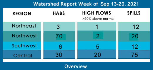
SEE BELOW FOR DETAILS
With the Flow – New York State Watershed Report for the Week of Sep 13-20
Number of new HABs are down across NYS this week, but more extensive: Widespread/Lakewide Blooms more common
New York City’s water supply is drawn from two primary surface water source areas: the Catskill/Delaware (96%) and Croton (4%); subregions of the Delaware and Lower Hudson River Watersheds, respectively. Drinking water is collected in 19 reservoirs and three controlled lakes from a 2,000-square-mile basin. One billion gallons of safe drinking water are distributed daily to the city’s 8.3 residents, along with an additional million residents of Westchester, Putnam, Orange, and Ulster Counties. (New York City 2020 Water Quality Report.
Report Key:
High Flows: WTNY reports systems flowing more than 90% over mean flow rate, categorized as “much above normal” and “high”, based on USGS WaterWatch real time streamflow for Sep 6,7/21.
Visit USGS WaterWatch for real time stream flows.
See also, National Weather Service high water terminology here https://www.weather.gov/aprfc/terminology
HABs – reporting confirmed hazardous algal blooms (cyanobacteria) confirmed as active on NYS HABs Notice, for the period Sept 3-6
Spills Report– hazardous materials spill incidents by county, listed in the pertinent watershed, as appearing in the NYS Environmental Sites Database, Spill Incidents Database as records are uploaded, covering the period Sep 5-11
See Watershed Basics Glossary for details on each report.
Northeast Watersheds– emptying into Atlantic Ocean via St. Lawrence River
Central NY Watersheds emptying into Altantic Ocean at Long Island Sound
Mohawk River Watershed
The Mohawk River originates in the western Adirondacks and the Tug Hill Plateau and flows 140 miles to the east where it joins the Hudson River. Sections of the Mohawk River also serve as the New York State Barge (Erie) Canal.
Including Schoharie Creek, West Canada Creek, East Canada Creek; Hinkley Reservoir, Delta Reservoir, Peck Lake, Schoharie Reservoir; joins the Hudson River below Albany.
High Flows: no high flows this week, the following systems are “much above normal”, over 90th percentile flow
- Schoharie Creek is flowing much above normal at Prattsville, 168% above mean at 340 cfs; at North Blenheim, flowing much above normal, 883% above mean to 537 cfs; at Breakabeen, 1075% above mean at 882 cfs; at Burtonsville, 455% above mean to 1010 cfs
- Mohawk River at Cohoes, just before the confluence with Upper Hudson is flowing much above normal, 203% above mean at 4770 cfs
- Mine Kill near North Blenheim is flowing much above normal, 354% above mean at 14.3 cfs
- Platter Kill at Gilboa is up 99% above mean flow at 10 cfs
- Manor Kill at West Conesville near Gilboa is flowing much above normal, 310% above mean at 31 cfs
HABs – none reported as of Sept 14
Spill Report
Montgomery County: none reported
Schoharie County: none reported
Upper Hudson River Watershed
The Upper Hudson River Watershed drains the south side of the Adirondack Mountains and flows south to meet the Mohawk River.
Including Sacandaga River, Schroon River, Indian River, Fish Creek, Hoosic River, Batten Kill, Great Sacandaga Lake, Indian Lake, Schroon Lake, Saratoga Lake
High Flows – all systems are below the high rating this week, the following are still rated “much above normal”
- Hudson River is still above 90th percentile above Lock 1 at Waterford is flowing 200% above mean, at 7830 cfs; at Green Island, just below the confluence with Mohawk River, flow is rated much above normal this week, 179% above mean and 12,200 cfs
- Glowegee Creek is much above normal, flowing 350% above mean at 56.3 cfs before entering Fish Creek on its way to the Upper Hudson
- Sacandaga River at Stewart’s Bridge near Hadley, flowing 215% above mean at 4050 cfs
- Hoosic River near Eagle Bridge is flowing 513% above mean and 2210 cfs
- Batten Kill below Mill at Battenville is flowing much above normal, 185% above mean at 512 cfs
HABs
Sept 1 Saratoga Lake small localized bloom confirmed in Saratoga County
Sept 7,10 Moreau Lake large localized and small localized blooms confirmed in Saratoga County
Spill Report
Saratoga County:
-Equipment failure in Wilton caused 10 gallons of hydraulic oil to be spilled in the soil 09/08/21, unresolved
-Equipment failure in Greenfield caused 2 gallons of transformer oil to be spilled in the soil 09/10/21, unresolved
-Equipment failure in Clifton Park caused 10 gallons of gasoline to be spilled on an unknown resource 09/10/21, unresolved
Washington County:
-Other cause in Hudson Falls caused 3 gallons of #2 fuel oil to be spilled in the soil 09/09/21, unresolved
Warren County
-Deliberate cause in Queensbury caused unknown amounts of raw sewage to be spilled on an unknown resource 09/06/21, resolved 09/07/21
-Storm in Queensbury caused 1 gallon of transformer oil to be spilled in the soil 09/08/21, unresolved
-Storm in Queensbury caused 20 gallons of non PCB oil to be spilled in the soil 09/08/21, unresolved
Lower Hudson River Watershed
The Lower Hudson Watershed begins where the Mohawk River joins the Hudson system at the Troy Dam and extends down to Manhattan. The lower end of the Hudson system, 153 miles, is technically a tidal estuary, not a river.
Rondout/Wallkill Rivers, Stockport/Kinderhook Creeks, Catskill Creek, Esopus Creek, Croton River; Ashokan Reservoir, Rondout Reservoir, New Croton Reservoir, Alcove Reservoir, Cross River Reservoir, Muscoot/Upper New Croton Reservoir
High Flows: flows have slowed this week, none in high range, the following are still much above normal:
- Esopus Creek at Mount Marion is flowing much above normal, 380% above mean to 1240 cfs
- Kinderhook Creek at Rossman is flowing much above normal, 703% above mean at 1440 cfs
- Chestnut Creek at Grahamsville is flowing much above normal, 132% above mean, 36 cfs
HABs
Aug 31, Sep 7 Sleepy Hollow Lake two widespread blooms confirmed in Greene County
Sep 6 Lake Mohegan open water bloom confirmed in Westchester County
Sep 6 Lake Peekskill widespread bloom confirmed in Putnam County
Spill Report
Westchester County:
-Storm in Rye caused unknown amounts of #2 fuel oil to be spilled in the soil and sewer 09/06/21, unresolved
-Storm in Rye caused unknown amounts of waste oil to be spilled in the soil 09/06/21, unresolved
-Equipment failure in New Rochelle caused 50 gallons of dielectric fluid to be spilled on an unknown resource 09/07/21, resolved 09/07/21
-Equipment failure in New Rochelle caused 20 gallons of dielectric fluid to be spilled on an unknown resource 09/07/21, resolved 09/13/21
-Equipment failure in Elmsford caused unknown amounts of other material to be spilled on an unknown resource 09/01/21, resolved 09/07/21
-Equipment failure in Buchanan caused 10 gallons of hydraulic oil to be spilled on an unknown resource 09/07/21, unresolved
-Unknown cause in White Plains caused 20 gallons of diesel to be spilled in the soil 09/07/21, unresolved
-Storm in Rye Brook caused unknown amounts of #2 fuel oil to be spilled in the soil 09/07/21, unresolved
-Equipment failure in Ossining caused unknown amounts of #2 fuel oil to be spilled in the soi 09/07/21, unresolved
-Equipment failure in Bronxville caused 2 gallons of antifreeze to be spilled in the soil 09/07/21, resolved 09/07/21
-Traffic accident in Valhalla caused 2 gallons of antifreeze to be spilled in the soil 09/07/21, resolved 09/07/21
-Storm in Harrison caused unknown amounts of #2 fuel oil to be spilled on an unknown resource 09/08/21, unresolved
-Equipment failure in Cortlandt Manor caused unknown amounts of #2 fuel oil to be spilled on the soil 09/08/21, unresolved
-Storm in Mamaroneck caused unknown amounts of unknown petroleum to be spilled on an unknown resource 09/09/21, resolved 09/13/21
-Equipment failure in Pelham caused 0.5 gallons of biodiesel to be spilled in the soil 09/09/21, resolved 09/09/21
-Equipment failure in Rye caused unknown amounts of #2 fuel oil to be spilled on an unknown resource 09/09/21, unresolved
-Equipment failure in Pleasantville caused unknown amounts of #2 fuel oil to be spilled in the soil 09/09/21, unresolved
-Equipment failure in Cortlandt caused 5 gallons of hydraulic oil to be spilled on an impervious surface 09/10/21, unresolved
-Equipment failure in Cortlandt caused unknown amounts of #2 fuel oil to be spilled on an unknown resource 09/10/21, unresolved
-Unknown cause in Dobbs Gerry caused 0.75 gallons of unknown petroleum to be spilled on the soil 09/10/21, resolved 09/10/21
-Human error in Croton on Hudson caused 20 gallons of diesel to be spilled on an unknown resource 09/10/21, resolved 09/10/21
Orange County:
-Unknown cause in Salisbury Mills caused unknown amounts of unknown material to be spilled on the surface water 09/07/21, resolved 09/07/21
-Equipment failure in Goshen caused unknown amounts of #2 fuel oil to be spilled in the soil 09/08/21, resolved
-Equipment failure in Port Jervis caused 0.5 gallons of dielectric fluid to be spilled in the soil 09/08/21, resolved 09/14/21
-Unknown cause in Westtown caused unknown amounts of unknown material to be spilled in the soil and surface water 09/09/21, unresolved
-Equipment failure in Crawford caused unknown amounts of #2 fuel oil to be spilled in the soil 09/09/21, unresolved
-Equipment failure in Warwick caused unknown amounts of #2 fuel oil to be spilled on an unknown resource 09/10/21, unresolved
-Equipment failure in Middletown caused unknown amounts of #2 fuel oil to be spilled in the soil 09/10/21, unresolved
-Equipment failure in Middletown caused unknown amounts of #2 fuel oil to be spilled on an unknown resource 09/11/21, unresolved
-Equipment failure in Montgomery caused 1 gallon of transformer oil to be spilled on an unknown resource 09/11/21, resolved 09/13/21
Putnam County
-Equipment failure in Kent caused unknown amounts of #2 fuel oil to be spilled in the soil 09/07/21, unresolved
-Equipment failure in Mahopac caused unknown amounts of #2 fuel oil to be spilled in the soil 09/09/21, unresolved
-Equipment failure in Putnam Valley caused unknown amounts of #2 fuel oil to be spilled in the soil 09/10/21, unresolved
Columbia County:
-Traffic accident in Livingston caused 30 gallons of transformer oil to be spilled in the soil 09/11/21, unresolved
Delaware River Watershed
The headwaters flow down from the Catskill Mountains into Delaware Bay/Atlantic Ocean. The watershed area includes East Branch Delaware River, West Branch Delaware River, Neversink River, Mongaup River, Pepacton Reservoir, Cannonsville Reservoir and Neversink Reservoir.
High Flows:
- West Branch Delaware at at Walton is flowing much above normal, 157% above mean, 574 cfs; at Hale Eddy is flowing much above normal, 194% above mean, 1700 cfs;
- East Branch Delaware at Fishs Eddy is flowing much above normal, 134% above mean at 1590 cfs; at Harvard 162% above mean, 808 cfs; at Downsville 183% above mean, 672 cfs
- Mill Brook near Dunraven is flowing much above normal this week, 134% above mean, 50.7 cfs
- Beaver Kill at Cooks Falls is much above normal, 142% above mean and 741 cfs
- Callicoon Creek at Callicoon is flowing much above normal again this week, 484% above mean at 215 cfs
HABS:
Sept 6 Wallkill Pond open water bloom confirmed in Ulster County
Sep 14 Cannonsville Reservoir open water bloom confirmed in Delaware County
Spill Report:
Sullivan County:
-Traffic accident in Liberty caused unknown amounts of diesel to be spilled on an unknown resource 09/10/21, unresolved
-Traffic accident in Liberty caused unknown amounts of diesel to be spilled on an unknown resource 09/10/21, resolved 09/13/21
Delaware County: None reported
Ulster County:
-Unknown cause in Marlborough caused unknown amounts of unknown material to be spilled in the soil and drinking water 09/07/21, resolved 09/07/21
-Human error in Kerhonkson caused 5 gallons of gasoline to be spilled in the soil 09/07/21, resolved 09/08/21
-Equipment failure in Hurly caused unknown amounts of #2 fuel oil to be spilled in the soil 09/10/21, unresolved
Housatonic River Watershed
A small portion of the headwaters of the Housatonic lies in eastern New York State. These waters drain the Taconic and Berkshire Mountains before joining the Housatonic and eventually emptying into Long Island Sound. Includes Tenmile River, Green River, Indian Lake, Swift/Crane Ponds
High Flow: all flows are below the 90th percentile this week
HABs: none reported
Spill Report:
Dutchess County:
-Equipment failure in Staatsburg caused unknown amounts of #2 fuel oil to be spilled on the soil 09/08/21, unresolved
-Equipment failure in Hopewell Junction caused unknown amounts of #2 fuel oil to be spilled in the soil 09/08/21, unresolved
-Equipment failure in Wappingers Falls caused unknown amounts of gasoline to be spilled in the soil 09/08/21, unresolved
-Equipment failure in Clinton Corners caused unknown amounts of #2 fuel oil to be spilled on an unknown resource 09/09/21, unresolved
Ramapo River Watershed
The northern headwaters of the Passaic basin lie within a small portion of southeastern New York State, including the Ramapo and Hackensack Rivers drainage areas. It is the smallest watershed in New York State. Including Ramapo River, Hackensack River, Greenwood Lake, DeForest Lake.
High Flow: all flows below 90th percentile
HABs:
Sep 6 Little We Wah Lake widespread/lakewide bloom and small localized bloom confirmed in Orange County
Sep 7 De Forest Lake widespread/lakewide bloom confirmed in Rockland County
Spills Report:
Rockland County:
-Unknown cause in Airmont caused unknown amounts of raw sewage to be spilled in the sewer and surface water 09/09/21, unresolved
-Equipment failure in Airmont caused unknown amounts of #2 fuel oil to be spilled in the soil 09/09/21, unresolved
-Equipment failure in Nanuet caused unknown amounts of #2 fuel oil to be spilled in the soil 09/10/21, unresolved
-Unknown cause in Monsey caused 5 gallons of unknown petroleum to be spilled in the soil 09/10/21, unresolved
Atlantic Ocean/Long Island Sound Watershed
The Atlantic Ocean/Long Island Sound Watershed drains most of the New York City Metropolitan Area and all of Long Island. The drainage area includes all marine waters in New York Harbor, Long Island Sound, Block Island Sound, and along the South Shore of Long Island, and the fresh waters that drain into them.
Includes 1415 square miles of marine estuary waters, the Bronx River, Mamaroneck River, Mianus River, Peconic River, Kensico Reservoir, Lake Ronkonkoma.
High Flow:
- Bellmore Creek at Bellmore is flowing much above normal, 176% above mean at 5 cfs
- Sampawams Creek at Babylon is flowing high this week, 248% above mean, 17 cfs
HABs
Sep 8 Roth Pond widespread/lakewide bloom confirmed in Suffolk County
Sep 8, 16 Prospect Park Lake two widespread/lakewide blooms confirmed in Kings County
Sep 9, 16 Wainscott Pond two separate widespread blooms confirmed in Suffolk County
Sep 9 Georgica Pond 2 large localized blooms and a widespread/lakewide bloom confirmed in Suffolk County
Sep 10 Halsey Neck Pond bloom confirmed in Suffolk, extent not reported
Sep 10 Coopers Neck Pond bloom reported in Suffolk, extent not reported
Sep 13 The Lake In Central Park widespread bloom confirmed in Manhattan
Sep 13 Harlem Meer widespread/lakewide bloom confirmed in Manhattan
Sep 13 Turtle Pond widespread/lakewide bloom confirmed in Manhattan
Sep 13 Artist Lake small localized bloom confirmed in Suffolk County
Sep 14 Indian Pond widespread/lakewide bloom confirmed in Bronx
Sep 14 South Merritts Pond bloom confirmed in Suffolk County, extent not reported
Sep 9, 14 Agawam Lake widespread bloom confirmed in Suffolk County
Sep 9, 14 Mill Pond (Watermill) widespread/lakewide bloom confirmed in Suffolk County
Spill Report:
Kings (Brooklyn):
-Storm in Brooklyn caused unknown amounts of #2 fuel oil to be spilled in the soil 09/06/21, unresolved
-Unknown cause in Brooklyn caused unknown amounts of unknown petroleum to be spilled in the surface water 09/08/21, unresolved
Queens County:
-Equipment failure in Woodside caused 50 lbs of #2 fuel oil to be spilled on an unknown resource 09/06/21, resolved 09/09/21
-Storm in Queens caused unknown amounts of #2 fuel oil to be spilled on an unknown resource 09/07/21, resolved 09/07/21
-Equipment failure in Elmhurst caused unknown amounts of unknown petroleum to be spilled in the sewer 09/07/21, resolved 09/13/21
-unknown cause in Queens caused unknown amounts of gasoline to be spilled in the sewer 09/09/21, resolved 09/13/21
Nassau County:
-Equipment failure in Massapequa caused unknown amounts of #2 fuel oil to be spilled in the soi 09/06/21, unresolved
-Equipment failure in Oyster Bay caused 2 gallons of #2 fuel oil to be spilled on an unknown resource 09/07/21, resolved 09/07/21
-Equipment failure in Garden City caused 160 gallons of #2 fuel oil to be spilled in the soil 09/07/21, unresolved
-Equipment failure in Old Brookville caused unknown amounts of #2 fuel oil to be spilled in the soil 09/08/21, unresolved
-Equipment failure in glen Cove caused 16 gallons of gasoline to be spilled in an unknown resource 09/08/21, unresolved
-Equipment failure in Albertson caused 0.25 lbs of #2 fuel oil to be spilled in the soil, and sewer 09/09/21, unresolved
-Equipment failure in Lynbrook caused unknown amounts of #2 fuel oil to be spilled in the soil 09/10/21, unresolved
-Equipment failure in Roslyn caused 5 gallons of #2 fuel oil to be spilled in the soil 09/10/21, unresolved
Suffolk County
-Equipment failure in Wading River caused 10 gallons of transformer oil to be spilled in the soil 09/06/21, unresolved
-Equipment failure in Jamesport caused 10 gallons of gasoline to be spilled in the soil and sewer 09/07/21, unresolved
-Equipment failure in Sayville caused 10 gallons of transformer oil to be spilled on an unknown resource 09/07/21, unresolved
-Equipment failure in Northport caused unknown amounts of #2 fuel oil to be spilled on an unknown resource 09/08/21, unresolved
-Abandoned drums un Copiague caused unknown amounts of gasoline to be spilled in the soil 09/09/21, unresolved
-Equipment failure in Riverhead caused 1 gallon of transformer oil to be spilled in the soil 09/10/21, unresolved
Richmond County: none reported
Bronx County:
-Equipment failure in Bronx caused 30 gallons fo #2 fuel oil to be spilled in an unknown resource 09/07/21, unresolved
-Unknown cause in Bronx caused unknown amounts of unknown petroleum to be spilled in the soil 09/08/21, unresolved
-Abandoned drums in Bronx caused unknown amounts of #2 fuel oil to be spilled on an unknown resource 09/11/21, unresolved
Northeast Watersheds– emptying into Atlantic Ocean via St. Lawrence River
Lake Champlain Watershed –
The Lake Champlain Watershed drains the area between the Adirondack Mountains in northeastern New York State and the Green Mountains in northwestern Vermont.
Includes the Ausable River, Saranac River, Great Chazy River, Boquet River, Mettawee River, Ticonderoga Creek/Lake George, Lake George,
Upper Saranac Lake, Lower Saranac Lake, Lake Placid, Lake Champlain
High Flows: all within normal range or below normal, less than 90th percentile
HABs:
Sep 13 Paradox Lake small localized bloom confirmed in Essex County, first of the season
No HABs currently reported on Lake Champlain
Check local conditions for the day of your visit, cyanobacteria bloom conditions change rapidly. For more information see the 2021 State of the Lake Report, or visit lcbp.org
Lake Champlain Basin Program is a multi-jurisdiction cooperative effort to protect water quality, funded by federal EPA, Vermont, New York state and Province of Quebec departments of Health and Environment.
Spill Report:
Clinton County:
-Equipment failure in West Chazy caused unknown amounts of gasoline to be spilled on an unknown resource 09/08/21, unresolved
Essex County:
-Deliberate cause in North Hudson caused 15 gallons of asphalt sealer to be spilled on an impervious surface 09/09/21, unresolved
Black River Watershed – Filters and drains most of Jefferson and Lewis Counties along with parts of Herkimer, Hamilton and Oneida Counties.
Major tributaries in the system include Moose River, Beaver River, Independence River and Deer River, Stillwater Reservoir, Fulton Chain of Lakes, Lake Lila and Big Moose Lake.
High Flows: all flows below 90th percentile
HABs – none reported
Spill Report :
Jefferson County:
-Traffic Accident in Houndsfield caused unknown amounts of diesel to be spilled in surface water 09/06/21, resolved 09/07/21
-Human error in Alexandria Bay caused 2 lbs of engine oil to be spilled in surface water 09/07/21, resolved 09/07/21
-Equipment failure in Fort Drum caused 150 gallons of diesel to be spilled in the soil 09/09/21, unresolved
-Human error in Sackets Harbour caused 10 gallons of #2 fuel oil to be spilled on an unknown resource 09/10/21, resolved 09/14/21
-Traffic accident in Wilna caused 56 gallons of kerosene to be spilled in the surface water and soil 09/11/21, unresolved
Lewis County:
-Equipment failure in Copenhagen caused 10 gallons of hydraulic oil to be spilled in the soil 09/08/21, unresolved
St. Lawrence River Watershed -
185 km of the St. Lawrence River catches the runoff from the northern and western Adirondack Mountains, drawing from portions of eight states, a combined area of 5600 square miles.
St. Lawrence Watershed collects the flow from eleven thousand miles of freshwater rivers and streams, including the Oswegatchie River, Raquette River, Saint Regis River, Grass River and Indian River; including Black Lake, Cranberry Lake, Raquette Lake, Tupper Lake and Long Lake. Densely forested woodlands, peatlands and areas of flat agricultural plains make up the natural surface water filtration system of this watershed area.
High Flows:
- Raquette River at Raymondville is flowing much above normal, 185% above mean and discharging 2250 cfs; the rest of the system is flowing in normal range, less than 90th percentile above normal.
HAB’s
Sep 16, 17 Black Lake Large localized bloom and extent unreported blooms confirmed in St. Lawrence County
Spill Report
Franklin County: none reported
St. Lawrence County:
-Equipment failure in Massena caused 6 gallons of mineral oil to be spilled on an unknown surface 09/06/21, resolved 09/08/21
-Equipment failure in Raymondville caused 3 gallons of hydraulic oil to be spilled in the soil 09/07/21, resolved 09/07/21
-Deliberate cause in Potsdam caused 5 gallons of raw sewage to be spilled in the soil 09/07/21,resolved 09/08/21
-Equipment failure in Hermon caused 211 gallons of diesel to be spilled in the soil 09/09/21, unresolved
Northwest Watersheds – empties into Atlantic Ocean via Great Lakes and St. Lawrence River
Lake Ontario and Minor Tributaries
This watershed includes the areas between the larger rivers that drain into Lake Ontario. It is divided into western, central and eastern sections that stretch all along the Lake Ontario Shoreline.
*Includes Salmon River Reservoir, Sodus Bay, North Pond, Irondequoit Bay and Perch Lake; Salmon River, Oak Orchard Creek, Irondequoit Creek, Sandy Creek
High Flows: all systems below 90th percentile
HABs:
Sep 7, 13, 14 Lake Neatahwanta widespread/lakewide blooms and open water bloom confirmed in Fulton County, Oswego County
Spill Report
Orleans County: none reported
Wayne County:
-Unknown cause in Williamson caused unknown amounts of unknown petroleum to be spilled on an unknown resource 09/07/21, unresolved
-Deliberate cause in Williamson caused unknown amounts of unknown material to be spilled on an unknown resource 09/11/21, unresolved
Oswego County:
-Equipment failure in Oswego caused unknown amounts of #2 fuel oil to be spilled in the soil 09/08/21, unresolved
Niagara River/Lake Erie Watershed
The Niagara River drains an area encompassing more than 265,000 square miles in the north central United States and south-central Canada, including Tonawanda Creek, Cattaraugus Creek, Buffalo River; Attica Reservoir and Lime Lake.
High Flows: all flows under 90th percentile this week, normal or above normal range
HABs: none reported
Spill Report
Erie County:
-Equipment failure in Cheektowaga caused 15 lbs of hydraulic oil to be spilled on an unknown resource 09/06/21, resolved 09/08/21
-Equipment failure in Buffalo caused 5 gallons of hydraulic oil to be spilled on an unknown resource 09/08/21, resolved 09/09/21
-Equipment failure in Amherst caused unknown amounts of transformer oil to be spilled on an unknown resource 09/09/21, unresolved
Niagara County:
-Traffic accident in Wrights Corners caused 30 gallons of asphalt sealer to be spilled in the soil and impervious surface 09/07/21, unresolved
-Equipment failure in Niagara Falls caused 1 lbs of other material to be spilled in the air 09/09/21, resolved 09/09/21
-Equipment failure in North Tonawanda caused 2 gallons of hydraulic oil to be spilled on the soil and impervious surface 09/06/21, unresolved
-Equipment failure in Niagara Falls caused 5 gallons of other material to be spilled on an unknown resource 09/10/21, unresolved
Oswego River and Finger Lakes Watershed
Including Otisco, Skaneateles, Owasco, Cayuga, Oneida, Seneca, Keuka, Canandaigua and Canadice Lakes; Oneida River, Clyde River, Cayuga Lake Tributaries and Seneca Lake Tributaries
High Flow:
- Onandaga Creek at Spencer St. Syracuse is flowing much above normal this week, 300% above mean at 263 cfs
HABs: With a peak number of HABs reported end of August at 110, the region has declined in total active HABs the second week in a row to this week’s total of 60
Sep 4, 13 Waneta Lake small and large localized blooms confirmed in Steuben County
Sep 4, 16 Seneca Lake 2 small localized, 2 widespread and 3 large localized blooms confirmed in Schuyler County
Sep 7 Cayuga Lake large localized bloom confirmed in Cayuga County
Sep 13 Seneca Lake small localized bloom confirmed in Yates County
Sep 13 Cayuga Lake large and small localized blooms confirmed in Cayuga County
Sep 16 Seneca Lake 2 small localized blooms confirmed in Seneca County
Sep 16 Seneca Lake widespread/lakewide bloom confirmed in Seneca County
Sep 16 Seneca Lake 7 small localized blooms confirmed in Seneca County
Sep 16 Seneca Lake 2 small localized blooms confirmed in Yates County
Sep 16 Seneca Lake 2 large localized blooms confirmed in Seneca County
Sep 16 Cayuga Lake 3 widespread/lakewide blooms confirmed in Cayuga County
Sep 4 Seneca Lake 2 large localized blooms confirmed in Seneca County
Sep 13 Keuka Lake open water bloom confirmed in Steuben County
Sep 13 Keuka Lake small localized bloom confirmed in Yates County
Sep 13 Cayuga Lake small localized bloom confirmed in Cayuga County
Sep 13 Owasco Lake small localized bloom confirmed in Cayuga County
Sep 14 Owasco Lake open water bloom confirmed in Cayuga County
Sep 16 Owasco Lake 3 large localized and 1 widespread/lakewide bloom confirmed in Cayuga County
Sep 16 Cayuga Lake widespread/lakewide bloom confirmed in Cayuga County
Sep 16 Cayuga Lake, 3 small localized blooms confirmed in Tompkins County
Sep 16 Skaneateles Lake 2 large localized blooms confirmed in Cayuga County
Sep 16 Skaneateles Lake 9 large localized blooms, 4 small localized bloom confirmed in Onondaga County
Check local conditions before venturing out to the lakes this week, HABs appear rapidly and toxins may remain in the water for a period after the bloom is gone.
Links to Harmful Algal Bloom Action Plans for Owasco, Cayuga and Skaneateles are below:
Owasco Lake Harmful Algal Bloom Action Plan (PDF)
Cayuga Lake Harmful Algal Bloom Action Plan (PDF)
Skaneateles Lake Harmful Algal Bloom Action Plan (PDF)
DEC HABs Brochure http://www.dec.ny.gov/docs/water_pdf/habsbrochure.pdf and FAQs http://www.dec.ny.gov/chemical/91570.html
Summary of 2020 Harmful Algal Bloom (HAB) Notification Season
DEC has posted a summary of the 2020 Harmful Algal Bloom (HAB) notices to the HABs Archive webpage. During 2020, 184 waterbodies statewide were listed on the NY HABs System (NYHABS). Nearly 2,000 HAB reports were collected by DEC and its partners, and of these, over 900 met DEC criteria for a HAB. The reports ranged from a single observation to widespread blooms that were persistent throughout the season.
Historical data is available on Open NY (Search the catalog for "Harmful Algal Blooms"). Also, the 2012-2019 HABs Archive Summary includes HAB reports since DEC began the HABs Program.
Spill Report:
Seneca County: None reported
Onondaga County: - None reported
Cayuga County:
-Equipment failure in Port Byron caused 5 gallons of diesel to be spilled on an impervious surface 09/07/21, resolved 09/07/21
Schuyler County:
-No records available
Yates County:
-Unknown cause in Branchport caused unknown amounts of other material to be spilled on an unknown resource 09/11/21, unresolved
Ontario County:
-Equipment failure in Honeoye caused 20 gallons of diesel to be spilled on an impervious surface 09/07/21, resolved 09/08/21
Genesee River Watershed
Including Conesus Lake, Silver Lake, Mount Morris Reservoir, Hemlock Lake, Honeoye Lake; Cassadaga Creek, Honeoye Creek, Oatka Creek, Black Creek
High Flows:
- Honeoye Creek at Honeoye Falls is still flowing much above normal, 141% above mean at 38 cfs
HABs: Honeoye Lake plagued with dozens of confirmed HABs this season, currently at 5 active blooms in Ontario County
Sep 13 Honeoye Lake, 3 widespread/lakewide blooms, 2 open water blooms confirmed in Ontario County
Sep 13, 16 Conesus Lake large localized and widespread/lakewide blooms confirmed in Livingston County
Spill Report:
Livingston County:
-other cause in Livonia caused unknown amounts of gasoline to be spilled on an unknown resource 09/07/21, unresolved
Allegany County:
-Other cause in Angelica caused 10 gallons of transformer oil to be spilled in the soil 09/08/21, unresolved
Monroe County:
-Equipment failure in Rochester caused unknown amounts of transformer oil to be spilled in the sewer 09/07/21, unresolved
-Unknown cause in Rochester caused unknown amounts of transformer oil to be spilled on an unknown resource 09/07/21, unresolved
-Equipment failure in Rochester caused 10 gallons of #2 fuel oil to be spilled on an unknown resource 09/09/21, resolved 09/10/21
-Equipment failure in Webster caused 10 gallons of herbicides to be spilled on an impervious surface 09/09/21, resolved 09/10/21
-Equipment failure in Rochester caused unknown amounts of propane gas to be spilled in the air 09/10/21, resolved 09/13/21
Genesee County: none reported
Wyoming County: none reported
Southwest Watersheds – Allegheny, emptying into Gulf of Mexico via Ohio River/Mississippi River; Chemung and Susquehanna emptying into Atlantic Ocean via Chesapeake Bay
Allegheny River Watershed (flowing west into Ohio River system)
Including Allegheny River, Chadakoin River, Conewango Creek, Canaseraga Creek, Cassadaga Creek, Olean Creek, Great Valley Creek, French Creek, Allegheny Reservoir, Chautauqua Lake
High Flows: flows in normal range again this week
HABs:
Sep 13 Chautauqua Lake 4 active HABs confirmed, from small to large localized blooms in Cattaraugus County
Spill Report:
Cattaraugus County:
-Other cause in Olean caused unknown amounts of crude oil to be spilled on the soil 09/07/21, unresolved
-Other cause in Olean caused unknown amounts of crude oil to be spilled in the soil 09/07/21, unresolved
Chautauqua County: none reported
Chemung River Watershed
The Chemung River flows across the western portion of Southern Tier of New York State before joining the Susquehanna River and eventually emptying into the Chesapeake Bay.
Including Cohocton River, Tioga/Canisteo River; Lamoka Lake/Mill Pond, Waneta Lake, Almond Lake
High Flows:
- Chemung River at Chemung is flowing much above normal, 133% above mean to 1690 cfs
HABs: none reported
Spill Report:
Chemung County: none reported
Steuben County:
-Other cause in Corning caused unknown amounts of gasoline to be spilled on the soil and groundwater 09/07/21, unresolved
-Equipment failure in Hornby caused 4 gallons of antifreeze to be spilled on the soil 09/09/21, resolved 09/09/21
-Equipment failure in Corning caused 1 gallon of antifreeze to be spilled on the soil 09/09/21, resolved 09/09/21
-Human error in Bath caused 2 gallons of gasoline and 5 gallons of diesel to be spilled on an impervious surface 09/09/21, unresolved
-Equipment failure in Erwin caused 15 gallons of gasoline to be spilled on an unknown resource 09/10/21, unresolved
Susquehanna River Watershed
The Susquehanna River drains 27,500 square miles covering large parts of New York, Pennsylvania and Maryland before emptying into the Chesapeake Bay.
Including Chenango River, Tioughnioga River, Unadilla River, Owego Creek; Otsego Lake, Canadarago Lake, Whitney Point Lake/Reservoir
High Flows
- Canisteo River below Canacadea Creek at Hornell is flowing much above normal this week, 147% above mean at 123 cfs
- Cohocton River at Campbellton is flowing much above normal, 225% above mean, 451 cfs
- Susquehanna River at at Unadilla is flowing over 90th percentile, 226% above mean at 757 cfs; at Conklin 221% above mean at 3570 cfs and at Vestal is much above normal, 287% above mean at 6180 cfs, at Waverly is much above normal, 230% above mean at 8230 cfs
- Chenango River at Sherburne is flowing much above normal, 204% above mean, 248 cfs, at Greene is 305% above mean, 702 cfs; at Chenango Forks 172% above mean at 1790 cfs;
HABs –
Sep 7 Guilford Lake open water bloom confirmed in Chenango County
Sep 12 Thunder Lake open water bloom confirmed in Chenango County
Spill Report:
Broome County:
-Other cause in Vestal caused unknown amounts of other material to be spilled on an unknown resource 09/09/21, resolved 09/13/21
-Unknown cause in Kirkwood caused 20 gallons of asphalt to be spilled in the soil 09/10/21, unresolved
Chenango County: None reported
Cortland County:
-Equipment failure in Cortland caused 5 gallons of other material to be spilled on an unknown resource 09/07/21, resolved 09/07/21
-Equipment failure in Cortland caused 3 gallons of mineral oil to be spilled in the soil 09/08/21, unresolved
-Equipment failure in Harford caused unknown amounts of propane gas to be spilled into the air 09/09/21, resolved 09/13/21
Otsego County: none reported
Tioga County: none reported
|