2021/9/29
Watershed Report
With the Flow – New York State Watershed Report for the Week of Sep 27-Oct 3
130 spills across NYS this week. Largest in New Rochelle, 250 gal of chlorine
By Gillian Ward
OVERVIEW
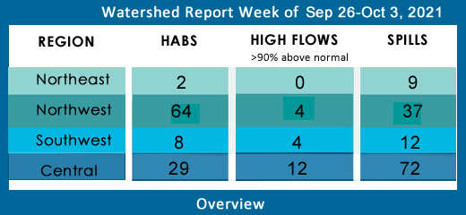
SEE BELOW FOR DETAILS
With the Flow – New York State Watershed Report for the Week of Sep 27-Oct 3
Report Key:
High Flows: WTNY reports systems flowing more than 90% over mean flow rate, categorized as “much above normal” and “high”, based on USGS WaterWatch real time streamflow for Sep 27,28
Visit USGS WaterWatch for real time stream flows.
See also, National Weather Service high water terminology here https://www.weather.gov/aprfc/terminology
HABs – reporting confirmed hazardous algal blooms (cyanobacteria) confirmed as active on NYS HABs Notice, for the period Sept 15-29
Spills Report– hazardous materials spill incidents by county, listed in the pertinent watershed, as appearing in the NYS Environmental Sites Database, Spill Incidents Database as records are uploaded, covering the period Sep 17-23
See Watershed Basics Glossary for details on each report.
Central NY Watersheds emptying into Atlantic Ocean at Long Island Sound
Mohawk River Watershed
The Mohawk River originates in the western Adirondacks and the Tug Hill Plateau and flows 140 miles to the east where it joins the Hudson River. Sections of the Mohawk River also serve as the New York State Barge (Erie) Canal.
Including Schoharie Creek, West Canada Creek, East Canada Creek; Hinkley Reservoir, Delta Reservoir, Peck Lake, Schoharie Reservoir; joins the Hudson River below Albany.
High Flows: all flows below 90th percentile
HABs:
Ilion Reservoir widespread/lakewide bloom confirmed Sep 14 in Herkimer County remains active
Spill Report
Montgomery County: none reported
Schoharie County: none reported
Upper Hudson River Watershed
The Upper Hudson River Watershed drains the south side of the Adirondack Mountains and flows south.
Including Sacandaga River, Schroon River, Indian River, Fish Creek, Hoosic River, Batten Kill, Great Sacandaga Lake, Indian Lake, Schroon Lake, Saratoga Lake
High Flows –
- Hudson River near Newcomb is flowing much above normal, 240% above mean, 563 cfs; at North Creek is flowing much above normal, 203% above mean at 1910 cfs; at Hadley, flowing much above normal at 239% above mean at 3480 cfs; Fort Edward is flowing much above normal at 188% above mean, 5990 cfs; above Lock 1 at Waterford is much above normal, 245% above mean at 10,700 cfs
- Glowegee Creek is still flowing much above normal this week in Upper Hudson watershed, 285% above mean, 38 cfs before entering Fish Creek on its way to the Upper Hudson
- Hoosic River near Eagle Bridge is flowing much above normal, 300% above mean
- -Batten Kill is flowing much above normal below Mill at Battenville, 257% above mean 655 cfs
- Sacandaga River is flowing much above normal at Stewart’s Bridge near Hadley, 204% above mean at 3980 cfs
HABs
Sep 19 Moreau Lake small localized bloom confirmed in Saratoga County; Sep 16 bloom remains in active status
Sep 20 Saratoga Lake widespread/lakewide bloom confirmed in Saratoga County; the large localized bloom confirmed Sep 17 in Saratoga County remains active
Spill Report
Saratoga County:
-Other cause in Gansevoort caused unknown amounts of other material to be spilled on an unknown resource 09/23/21, unresolved
-Other cause in Stillwater caused 3 gallons of transformer oil to be spilled on an unknown resource 09/23/21, unresolved
-Equipment failure in Vischer Ferry caused 2.5 lbs of hydraulic oil to be spilled in the soil 09/24/21, unresolved
Washington County:
-Equipment failure in Greenwich caused 100 gallons of diesel to be spilled on an unknown resource 09/20/21, unresolved
-Tank Test Failure in Glenville caused unknown amounts of gasoline to be spilled on an unknown resource 09/22/21, unresolved
-Other cause in Granville caused unknown amounts of gasoline to be spilled on an unknown resource 09/23/21, unresolved
Warren County:
-Equipment failure in Hague caused 2lbs of gasoline to be spilled in the surface water 09/18/21, unresolved
-Traffic accident in Bolton Landing caused unknown amounts of pesticides to be spilled on an unknown resource 09/21/21, unresolved
-Housekeeping in Bolton caused 1 gallon of unknown petroleum to be spilled in the soil 09/22/21, unresolved
Lower Hudson River Watershed
The Lower Hudson Watershed begins where the Mohawk River joins the Hudson system at the Troy Dam and extends down to Manhattan. The lower end of the Hudson system, 153 miles, is technically a tidal estuary, not a river.
Rondout/Wallkill Rivers, Stockport/Kinderhook Creeks, Catskill Creek, Esopus Creek, Croton River; Ashokan Reservoir, Rondout Reservoir, New Croton Reservoir, Alcove Reservoir, Cross River Reservoir, Muscoot/Upper New Croton Reservoir
High Flows: flows have slowed this week, none in high range, the following are still much above normal:
- Esopus Creek at Mount Marion is flowing much above normal, 410% above mean to 1200 cfs
- Valatie Kill near Nassau is flowing much above normal, 444% at 14 cfs
- Kinderhook Creek at Rossman has slowed this week, but still flowing much above normal, 540% above mean at 890 cfs
HABs
Sep 18 Beaver Dam Lake open water bloom confirmed in Orange County
Sep 20,21 Roaring Brook Lake two small localized blooms confirmed in Putnam County
Sep 20 Tomkins Lake small localized bloom confirmed in Rockland County
Spill Report
Westchester County:
-Equipment failure in Mount Kisco caused 10 gallons of #2 fuel oil to be spilled on an unknown resource 09/18/21, resolved 09/21/21
-Unknown cause in Mamaroneck caused 30 gallons of #2 fuel oil to be spilled in surface water 09/18/21, unresolved
-Traffic accident in Rye caused unknown amounts of transformer oil to be spilled on an unknown resource 09/19/21, resolved 09/20/21
-Equipment failure in Yorktown caused 30 gallons of hydraulic oil to be spilled on an unknown resource 09/19/21, resolved 09/20/21
-Unknown cause in Mount Pleasant caused unknown amounts of #2 fuel oil to be spilled in the soil, surface water and sewer 09/19/21, resolved 09/20/21
-Equipment failure in Thornwood caused unknown amounts of #2 fuel oil to be spilled in the soil 09/19/21, unresolved
-Unknown cause in New Rochelle caused 250 gallons of chlorine to be spilled in the surface water 09/20/21, resolved 09/20/21
-Equipment failure in Yorktown caused unknown amounts of #2 fuel oil to be spilled in the soil and impervious surface 09/20/21, resolved 09/20/21
-Equipment failure in Rye caused unknown amounts of #2 fuel oil to be spilled in the soil09/20/21, unresolved
-Equipment failure in Yonkers caused 1 gallon of other material to be spilled on an unknown resource 09/21/21, unresolved
-Equipment failure in Lincolndale caused unknown amounts of #2 fuel oil to be spilled in the soil 09/21/21, unresolved
Orange County:
-Equipment failure in Middletown caused 0.25 gallons of transformer oil to be spilled in the soil 09/20/21, resolved 09/20/21
-Equipment failure in Pine Bush caused unknown amounts of #2 fuel oil to be spilled in the soil 09/20/21, unresolved
-Equipment failure in Pine Bush caused unknown amounts of #2 fuel oil to be spilled in the soil 09/20/21, unresolved
-Equipment failure in West Point caused 3 gallons of raw sewage to be spilled on an unknown resource 09/20/21, resolved 09/21/21
-Equipment failure in West Point caused 5 gallons of sodium hypochlorite to be spilled on the soil 09/20/21, resolved 09/21/21
-Equipment failure in Campbell Hill caused unknown amounts of #2 fuel oil to be spilled in the soil 09/21/21, unresolved
-Equipment failure in New Windsor caused unknown amounts of #2 fuel oil to be spilled in the soil 09/21/21, resolved 09/24/21
-Unknown cause in Goshen caused unknown amounts of diesel to be spilled on the soil and ground water 09/21/21, unresolved
-Traffic accident in Newburgh caused unknown amounts of flammables to be spilled on to an unknown resource 09/22/21, unresolved
-Traffic accident in Newburgh caused unknown amounts of acetone to be spilled on an unknown resource 09/22/21, resolved 09/22/21
Putnam County:
-Unknown cause in Brewster caused unknown amounts of unknown material to be spilled on surface water 09/19/21, unresolved
-Equipment failure in Carmel caused unknown amounts of #2 fuel oil to be spilled in the soil 09/22/21, unresolved
-Equipment failure in Mahopac caused unknown amounts of #2 fuel oil to be spilled in the soil 09/23/21, unresolved
-Equipment failure in Mahopac caused unknown amounts of #2 fuel oil to be spilled in the soil 09/24/21, unresolved
-Equipment failure in Paterson caused unknown amounts of #2 fuel oil to be spilled in the soil 09/24/21, unresolved
Columbia County:
-Equipment failure in Claverack caused unknown amounts of #2 fuel oil to be spilled on the soil 09/24/21, unresolved
Delaware River Watershed
The headwaters flow down from the Catskill Mountains into Delaware Bay/Atlantic Ocean. The watershed area includes East Branch Delaware River, West Branch Delaware River, Neversink River, Mongaup River, Pepacton Reservoir, Cannonsville Reservoir and Neversink Reservoir.
High Flows:
- West Branch Delaware at Stilesville is flowing much above normal, 222% above mean at 1400 cfs, at Hale Eddy is still flowing much above normal, 220% above mean, 1630 cfs;
- East Branch Delaware at Downsville 317% above mean, 684 cfs; at Harvard 277% above mean, 997 cfs;
- Neversink River at Neversink is flowing much above normal 192% above mean at 183 cfs
- Mongaup River near Mongaup has throttled down to less than 90th percentile, flowing 479% above mean at 970 cfs
HABS:
Sep 19 Cannonsville Reservoir large localized bloom confirmed in Delaware County remains active
Spill Report:
Sullivan County:
-Equipment failure in Roscoe caused unknown amounts of #2 fuel oil to be spilled in the soil 09/20/21, unresolved
-Unknown cause in White Lake caused unknown amounts of unknown petroleum to be spilled in the sewer 09/23/21, unresolved
-Other cause in Willowemoc caused unknown amounts of transformer oil to be spilled on an unknown resource 09/23/21, unresolved
-Equipment failure in Monticello caused unknown amounts of #2 fuel oil to be spilled in the soil 09/24/21, unresolved
Delaware County:
-Traffic accident in Colchester caused unknown amounts of gasoline to be spilled on an unknown material 09/24/21, unresolved
Ulster County:
-Equipment failure in New Paltz caused 30 gallons of diesel to be spilled on an unknown resource 09/18/21, unresolved
-Equipment failure in Plattekill caused 15 gallons of diesel to be spilled on an unknown resource 09/20/21, resolved 09/21/21
-Traffic accident in Esopus caused unknown amounts of unknown petroleum to be spilled on an unknown resource 09/22/21, resolved 09/22/21
-Equipment failure in Stone Ridge caused unknown amounts of #2 fuel oil to be spilled on an unknown resource 09/23/21, unresolved
Housatonic River Watershed
A small portion of the headwaters of the Housatonic lie in eastern New York State. These waters drain the Taconic and Berkshire Mountains before joining the Housatonic and eventually emptying into Long Island Sound. Includes Tenmile River, Green River, Indian Lake, Swift/Crane Ponds
High Flow: all flows are below 90th percentile this week
HABs: none reported
Spill Report:
Dutchess County:
-Equipment failure in Holmes caused unknown amounts of #2 fuel oil to be spilled on an unknown resource 09/21/21, unresolved
-Storm in Barrytown caused 15 gallons of transformer oil to be spilled in the soil 09/24/21, unresolved
Ramapo River Watershed
The northern headwaters of the Passaic basin lie within a small portion of southeastern New York State, including the Ramapo and Hackensack Rivers drainage areas. It is the smallest watershed in New York State. Including Ramapo River, Hackensack River, Greenwood Lake, DeForest Lake.
High Flow: all flows below 90th percentile
HABs: none reported
Spills Report:
Rockland County:
-Deliberate cause in Wesley Hills caused unknown amounts of raw sewage to be spilled on an unknown resource 09/19/21, resolved 09/20/21
-Storm in Orangeburg caused unknown amounts of unknown petroleum to be spilled in the soil 09/23/21, unresolved
-Equipment failure in Suffern caused unknown amounts of transformer oil to be spilled in the soil 09/24/21, unresolved
Atlantic Ocean/Long Island Sound Watershed
The Atlantic Ocean/Long Island Sound Watershed drains most of the New York City Metropolitan Area and all of Long Island. The drainage area includes all marine waters in New York Harbor, Long Island Sound, Block Island Sound, and along the South Shore of Long Island, and the fresh waters that drain into them.
Includes 1415 square miles of marine estuary waters, the Bronx River, Mamaroneck River, Mianus River, Peconic River, Kensico Reservoir, Lake Ronkonkoma.
High Flow: all flows in normal range or below 90th percentile
HABs –
Sept 17 Morningside Pond widespread/lakewide bloom confirmed in Manhattan
Sep 20 Agawam Lake widespread bloom confirmed in Suffolk County, the widespread bloom confirmed Sep 14 remains active
Sep 20 Mill Pond (Watermill) widespread/lakewide bloom confirmed in Suffolk County, the widespread bloom confirmed Sep 14 remains active
Sep 20 Wainscott Pond widespread bloom confirmed in Suffolk County, Sep 16 widespread bloom remains active
Sep 20 Georgica Pond two unspecified extent blooms confirmed in Suffolk County, Sep 16 widespread bloom remains active
Sep 23 The Lake In Central Park widespread bloom confirmed in Manhattan, the widespread bloom reported Sep 16 remains active
Sep 23 Kissena Lake widespread/lakewide bloom confirmed in Queens County
Sep 23 Goose Pond widespread/lakewide bloom confirmed in Queens County
Sep 24 Turtle Pond widespread/lakewide bloom confirmed in Manhattan, the widespread bloom confirmed Sep 13 remains active
Sep 24 Prospect Park Lake widespread/lakewide bloom confirmed in Kings County
Indian Pond widespread/lakewide bloom confirmed Sep 14 in the Bronx remains active
South Merrits Pond bloom confirmed in Suffolk County Sept 14 remains active this week.
Spill Report:
Kings (Brooklyn):
-Deliberate cause in Brooklyn caused unknown amounts of other material to be spilled on an unknown resource 09/21/21, resolved 09/21/21
-Equipment failure in Brooklyn caused unknown amounts of hydraulic oil to be spilled on an unknown resource 09/22/21, unresolved
-Other cause in Brooklyn caused unknown amounts of unknown material to be spilled in the soil 09/23/21, resolved 09/24/21
Queens County:
-Unknown cause in Queens caused unknown amounts of #2 fuel oil to be spilled on an unknown resource 09/18/21, unresolved
-Equipment failure in Long Island City caused unknown amounts of #2 fuel oil to be spilled on an unknow resource 09/20/21, unresolved
-Unknown cause in Flushing caused unknown amounts of unknown petroleum to be spilled on an unknown resource 09/21/21, unresolved
-Storm in Astoria caused unknown amounts of #2 fuel oil to be spilled in the soil 09/21/21, unresolved
Nassau County:
-Equipment failure in Garden City caused 5 gallons of hydraulic oil to be spilled on an unknown resource 09/19/21, unresolved
-Equipment failure in Plainview caused 40lbs of diesel to be spilled on an impervious surface 09/21/21, unresolved
-Traffic accident in Plainview caused 50 gallons of diesel to be spilled on an unknown resource 09/21/21, unresolved
-Equipment failure in Wantagh caused 200 gallons of #2 fuel oil to be spilled on an unknown resource 09/21/21, resolved 09/21/21
-Equipment failure in Wantagh caused unknown amounts of unknown petroleum to be spilled on an unknown resource 09/21/21, unresolved
Suffolk County:
-Equipment failure in Sayville caused 1 gallon of transformer oil to be spilled on an unknown resource 09/20/21, unresolved
-Traffic accident in Smithtown caused 15 gallons of gasoline to be spilled on the soil and impervious surface 09/20/21, unresolved
-Unknown cause in Quogue caused unknown amounts of #2 fuel oil to be spilled in the soil 09/20/21, unresolved
-Equipment failure in Dix Hills caused 1 gallon of transformer oil to be spilled on an unknown resource 09/21/21, unresolved
Richmond County:
-Equipment failure in Staten Island caused unknown amounts of transformer oil to be spilled in the soil 09/20/21, unresolved
-Deliberate cause in Staten Island caused unknown amounts of other material to be spilled on an unknown resource 09/21/21, resolved 09/21/21
-Other cause in Staten Island caused unknown amounts of paint to be spilled on an unknown resource 09/22/21, unresolved
Bronx County:
-Unknown cause in the Bronx caused unknown amounts of unknown hazardous material to be spilled on an unknown resource 09/20/21, resolved 09/20/21
-Unknown cause in the Bronx caused 10 gallons of unknown petroleum to be spilled on an unknown resource 09/21/21, unresolved
-Abandoned drums in the Bronx caused unknown amounts of unknown petroleum to be spilled on an unknown resource 09/22/21, unresolved
Northeast Watersheds– emptying into Atlantic Ocean via St. Lawrence River
Lake Champlain Watershed –
The Lake Champlain Watershed drains the area between the Adirondack Mountains in northeastern New York State and the Green Mountains in northwestern Vermont.
Includes the Ausable River, Saranac River, Great Chazy River, Boquet River, Mettawee River, Ticonderoga Creek/Lake George, Lake George,
Upper Saranac Lake, Lower Saranac Lake, Lake Placid, Lake Champlain
High Flows: all within normal range or below normal, less than 90th percentile
HABs: none reported
Spill Report:
Clinton County:
-Equipment failure in Saranac caused 5 gallons of diesel to be spilled in the soil 09/20/21, unresolved
Essex County: none reported
St. Lawrence River Watershed -
185 km of the St. Lawrence River catches the runoff from the northern and western Adirondack Mountains, drawing from portions of eight states, a combined area of 5600 square miles.
St. Lawrence Watershed collects the flow from eleven thousand miles of freshwater rivers and streams, including the Oswegatchie River, Raquette River, Saint Regis River, Grass River and Indian River; including Black Lake, Cranberry Lake, Raquette Lake, Tupper Lake and Long Lake. Densely forested woodlands, peatlands and areas of flat agricultural plains make up the natural surface water filtration system of this watershed area.
High Flows: all flows below 90th percentile
HAB’s
Black Lake Large localized bloom and extent unreported bloom confirmed Sep 16,17 in St. Lawrence County remain active this week
Spill Report
Franklin County:
-Equipment failure in Bellmont caused unknown amounts of hydraulic oil to be spilled on an unknown resource 09/24/21, unresolved
St. Lawrence County:
-Equipment failure in Canton caused 6 gallons of hydraulic oil to be spilled on an unknown resource 09/20/21, unresolved
-Equipment failure in Unknown city caused 15 lbs of fire retardant foam to be spilled on an impervious surface 09/21/21, unresolved
Black River Watershed – Filters and drains most of Jefferson and Lewis Counties along with parts of Herkimer, Hamilton and Oneida Counties.
Major tributaries in the system include Moose River, Beaver River, Independence River and Deer River, Stillwater Reservoir, Fulton Chain of Lakes, Lake Lila and Big Moose Lake.
High Flows: all flows below 90th percentile
HABs – none reported
Spill Report :
Jefferson County:
-Equipment failure in Black River caused 33 gallons of hydraulic oil to be spilled on an unknown resource 09/21/21, unresolved
-Deliberate cause in LeRay caused unknown amounts of motor oil to be spilled in the soil 09/22/21, unresolved
-Traffic accident in LeRay caused unknown amounts of motor oil to be spilled in the soil 09/22/21, unresolved
-Equipment failure in LeRay caused 2 gallons of hydraulic oil to be spilled in the soil 09/23/21, unresolved
Lewis County:
-Equipment failure in Montague caused 3 gallons of hydraulic oil to be spilled in the soil 09/21/21, unresolved
Northwest Watersheds – empties into Atlantic Ocean via Great Lakes and St. Lawrence River
Lake Ontario and Minor Tributaries
This watershed includes the areas between the larger rivers that drain into Lake Ontario. It is divided into western, central and eastern sections that stretch all along the Lake Ontario Shoreline.
*Includes Salmon River Reservoir, Sodus Bay, North Pond, Irondequoit Bay and Perch Lake; Salmon River, Oak Orchard Creek, Irondequoit Creek, Sandy Creek
High Flows: all systems below 90th percentile
HABs:
Lake Neatahwanta widespread/lakewide bloom confirmed Sep 14 in Fulton County remain active this week
Spill Report
Orleans County: none reported
Wayne County:
-deliberate act in Williamson caused unknown amounts of unknown petroleum to be spilled on an unknown resource 09/21/22, resolved 09/22/21
Oswego County:
-Unknown cause in Brewerton caused unknown amounts of unknown petroleum to be spilled on surface water 09/20/21, resolved 09/21/21
-Traffic accident in Oswego caused 1 gallon of transformer oil to be spilled on an unknown resource 09/21/21, unresolved
-Other cause in Oswego caused unknown amounts of motor oil to be spilled on an unknown resource 09/21/21, unresolved
-Other cause in Oswego caused unknown amounts of motor oil to be spilled on an unknown resource 09/21/21, unresolved
-Deliberate cause in Oswego caused unknown amounts of unknown petroleum to be spilled on an unknown resource 09/22/21, unresolved
-Human error in Central Square caused unknown amounts of anti freeze to be spilled in the soil 09/23/21, unresolved
-Equipment failure in Scriba caused 28 gallons of hydraulic oil to be spilled on an unknown resource 09/24/21, unresolved
Niagara River/Lake Erie Watershed
The Niagara River drains an area encompassing more than 265,000 square miles in the north central United States and south central Canada, including Tonawanda Creek, Cattaraugus Creek, Buffalo River; Attica Reservoir and Lime Lake.
High Flows: all flows under 90th percentile this week, normal or above normal range
HABs: none reported
Spill Report
Erie County:
-Deliberate cause in Amherst caused unknown amounts of unknown material to be spilled on an unknown resource 09/18/21, unresolved
-Equipment failure in Lackawanna caused unknown amounts of #2 fuel oil to be spilled in the soil 09/20/21, unresolved
-Equipment failure in Buffalo caused unknown amounts of unknown petroleum to be spilled in the soil and ground water 09/20/21, unresolved
-Human error in Amherst caused unknown amounts of other material to be spilled on an unknown resource 09/20/21, resolved 09/20/21
-Equipment failure in Buffalo caused 5 gallons of hydraulic oil to be spilled on an impervious surface 09/20/21, resolved 09/20/21
-Traffic accident in West Seneca caused 20 gallons of diesel to be spilled on an impervious surface 09/22/21, unresolved
-Traffic accident in West Seneca caused 25 gallons of diesel to be spilled on an impervious surface 09/22/21, resolved 09/23/21
-Other cause in Buffalo caused unknown amounts of unknown petroleum to be spilled in the soil 09/24/21
Niagara County:
-Equipment failure in Model City caused 20 gallons of hydraulic oil to be spilled on the soil 09/19/21, unresolved
-Equipment failure in Niagara Falls caused 15 gallons of hydraulic oil to be spilled on an unknown resource 09/20/21, unresolved
-Equipment failure in Wilson caused 0.8 gallons of transformer oil to be spilled in the soil 09/23/21, unresolved
-Equipment failure in Niagara Falls caused 1 gallon of hydraulic oil to be spilled in the soil 09/24/21, resolved 09/24/21
Oswego River and Finger Lakes Watershed
Including Otisco, Skaneateles, Owasco, Cayuga, Oneida, Seneca, Keuka, Canandaigua and Canadice Lakes; Oneida River, Clyde River, Cayuga Lake Tributaries and Seneca Lake Tributaries
High Flow:
- Keuka Lake Outlet is flowing much above normal this week, 315% above mean at 266 cfs
- Canadaigua Outlet is also flowing over the 90th percentile, 464% above mean, 301 cfs
HABs: From the Fall 2020 Water Bulletin, Newsletter of the Community Science Institute, we get a detailed picture of water quality in the Finger Lakes region, including specific toxin levels (microcystin and anatoxin-A) While we have previously reported that the pattern of release of these cyanotoxins is still not well understood, there are patterns emerging in the distribution of the higher toxicity producing blooms.
The period of activity for observed HABs in Finger Lakes ranges from June to October, where last season, the peak number of blooms occurred in September, and the concentration of toxins reached as high as 1556.7 micrograms per liter (Cayuga Lake), 398 x the safe limit for recreational water.
Knowing when toxins are present in the water is important for recreational users, as even the spray from a boat motor can expose people to the toxins associated with skin rash, nausea and other health effects.
Canadaigua Lake: 10 ACTIVE BLOOMS
- Sep 16, 18, 19 four small localized blooms confirmed in Ontario County
- Sep 19 large localized and open water blooms confirmed in Ontario County
- Sep 19 large localized bloom confirmed in Yates County
- Sep 19 two small localized blooms confirmed in Ontario County
- Sep 23 large localized bloom confirmed in Ontario County
- Sep 25 small localized bloom confirmed in Ontario County
Seneca Lake: 16 Active Blooms
- South end, Schuyler County: one large, one small localized bloom confirmed Sep 16 remains active this week
- Mid-lake, Yates County (west side): a large localized bloom, widespread/lakewide bloom and small localized bloom confirmed Sep 16 remain active
- North end (west side) Sep 19 three large localized blooms confirmed in Yates County
- North end (east side) six small localized blooms, one large localized bloom and one lakewide bloom confirmed in Seneca County are active this week
Cayuga Lake: 9 Active Blooms
- South end, a small localized bloom confirmed in Tompkins County Sep 16 remains active
- Mid Lake, 3 small localized blooms confirmed in Tompkins (2) and Seneca County (1)
- North end, ten blooms are active, ranging from small localized, large localized to widespread/lakewide blooms confirmed in Cayuga County
Keuka Lake:
- Sep 16 large localized bloom confirmed in Yates County
Owasco Lake: 7 Active Blooms
- Sep 20 large localized bloom confirmed in Cayuga County (south end)
- Mid lake, 3 large localized, a widespread and an open water bloom confirmed Sep 16 in Cayuga County remain active
- North end, large localized bloom remains active from Sep 16
Skaneateles Lake: 18 Active Blooms
- South end, 3 large localized blooms and 1 small localized bloom confirmed in Cayuga County on Sep 16 remain active
- Midlake, 5 active blooms remain this week, confirmed in Onandaga County Sept 16
- north end, 9 active blooms remain, confirmed in Onandaga County Sept 15-16
Spill Report:
Seneca County:
-Equipment failure in Seneca Falls caused unknown amounts of hydraulic oil to be spilled in the sewer 09/22/21, resolved 09/24/21
Onondaga County:
-Equipment failure in Syracuse caused 1 gallon of transformer oil to be spilled on an impervious surface 09/20/21, resolved 09/20/21
-Traffic accident in Manlius caused 13 gallons of transformer oil to be spilled in the soil 09/21/21, unresolved
-Equipment failure in Syracuse caused unknown amounts of transmission fluid to be spilled on an unknown resource 09/21/21, unresolved
-Unknown cause in Skaneateles caused unknown amounts of fuel to be spilled in surface water 09/22/21, unresolved
-Equipment failure in Liverpool caused 3 gallons of anti freeze to be spilled in the soil 09/24/21, resolved 09/27/21
Schuyler County: none reported.
Yates County:
-Equipment failure in Penn Yan caused unknown amounts of raw sewage to be spilled on an unknown resource 09/21/21, unresolved
Ontario County: None reported
Genesee River Watershed
Including: Conesus Lake, Silver Lake, Mount Morris Reservoir, Hemlock Lake, Honeoye Lake; Cassadaga Creek, Honeoye Creek, Oatka Creek, Black Creek
High Flows:
- Conesus Creek is flowing high this week, 766% above mean, 114 cfs
- Genessee River at Ford St Bridge in Rochester is much above normal, 257% above mean at 3750 cfs
HABs:
Sep 16 Conesus Lake widespread/lakewide bloom confirmed in Livingston County
Sep 27 Honeoye Lake large localized bloom confirmed in Ontario County
Spill Report:
Livingston County:
-Equipment failure in Mount Morris caused 20 gallons of hydraulic oil to be spilled on an unknown resource 09/20/21, unresolved
-Equipment failure in Mount Morris caused 15 gallons of hydraulic oil to be spilled on an unknown resource 09/23/21, unresolved
-Housekeeping cause in Dansville caused unknown amounts of animal oils to be spilled in surface water and an impervious surface 09/24/21, unresolved
Allegany County:
-Deliberate cause in Bolivar caused unknown amounts of unknown petroleum to be spilled on an unknown resource 09/19/21, unresolved
-Abandoned drums in Allentown caused unknown amounts of unknown material to be spilled in the soil and ground water 09/20/21, unresolved
Monroe County:
-Traffic accident in Rochester caused 5 gallons of silver to be spilled in the soil and sewer 09/20/21, unresolved
-Other cause in Rochester caused unknown amounts of gasoline to be spilled on an unknown resource 09/21/21, resolved 09/21/21
-Equipment failure in Brighton caused 1 gallon of hydraulic oil to be spilled on an impervious surface 09/21/21, resolved 09/21/21
Genesee County:
-Other cause in Batavia caused unknown amounts of other material to be spilled into the air 09/22/21, resolved 09/22/21
Wyoming County:
-Equipment failure in Marysburg caused unknown amounts of diesel to be spilled into the soil 09/22/21, unresolved
Southwest Watersheds – Allegheny, emptying into Gulf of Mexico via Ohio River/Mississippi River; Chemung and Susquehanna emptying into Atlantic Ocean via Chesapeake Bay
Allegheny River Watershed (flowing west into Ohio River system)
Including Allegheny River, Chadakoin River, Conewango Creek, Canaseraga Creek, Cassadaga Creek, Olean Creek, Great Valley Creek, French Creek, Allegheny Reservoir, Chautauqua Lake
High Flows: flows in normal range again this week
HABs:
Sep 16, 18 Chautauqua Lake open water bloom, large localized bloom and widespread bloom confirmed in Cattaraugus County
Sep 20 Chautauqua Lake large localized bloom confirmed in Cattaraugus County
Spill Report:
Cattaraugus County:
-Equipment failure in Conewango Valley caused 5 gallons of hydraulic oil to be spilled in the soil 09/18/21, resolved 09/20/21
-Equipment failure in Olean caused unknown amounts of #2 fuel oil to be spilled in the soil 09/21/21, unresolved
-Other cause in Great Valley caused 3 gallons of transformer oil to be spilled in the soil 09/23/21, resolved 09/23/21
Chautauqua County: None reported.
Chemung River Watershed
The Chemung River flows across the western portion of Southern Tier of New York State before joining the Susquehanna River and eventually emptying into the Chesapeake Bay.
Including Chemung River, Cohocton River, Tioga/Canisteo River; Lamoka Lake/Mill Pond, Waneta Lake, Almond Lake
High Flows:
- Cohocton River near Campbell has nearly doubled in flow volume over last week, flowing much above normal, 276% above mean to 483 cfs
- Tioga River at Lindley is flowing much above normal, 300% above mean, 920 cfs
- Chemung River at Chemung is flowing much above normal, 323% above mean, 3010 cfs
HABs: none reported
Spill Report:
Chemung County:
-Equipment failure in Elmira caused 10 gallons of mineral oil to be spilled on the soil and impervious surface 09/20/21, unresolved
-Equipment failure in Elmira caused 50 gallons of hydraulic oil to be spilled on an impvervious surface 09/22/21
Steuben County: none reported.
Susquehanna River Watershed
The Susquehanna River drains 27,500 square miles covering large parts of New York, Pennsylvania and Maryland before emptying into the Chesapeake Bay.
Including: Chenango River, Tioughnioga River, Unadilla River, Owego Creek; Otsego Lake, Canadarago Lake, Whitney Point Lake/Reservoir
High Flows :
- Susquehanna River at Vestal is flowing much above normal, 271% above mean at 5430 cfs
HABs –
Sep 19 Song Lake two small localized blooms reported and confirmed in Cortland County
Sep 16 DeRuyter Reservoir widespread/lakewide bloom confirmed in Madison County
Sep 17 Bradley Brook Reservoir small localized bloom confirmed in Madison County
Spill Report:
Broome County:
-Equipment failure in Binghamton caused unknown amounts of leachate to be spilled in the soil and sewer 09/20/21, resolved 09/20/21
-Equipment failure in Binghamton caused unknown amounts of raw sewage to be spilled in the soil and surface water 09/20/21. resolved 09/20/21
-Other cause in Vestal caused unknown amounts of unknown petroleum to be spilled in the soil and ground water 09/21/21, unresolved
-Equipment failure in Binghamton caused unknown amounts of diesel to be spilled in the soil 09/21/21, unresolved
Chenango County:
-none reported
Cortland County:
-Unknown cause in Homer caused unknown amounts of hydraulic oil to be spilled in the soil 09/21/21, unresolved
Otsego County:
-Equipment failure in Oneonta caused unknown amounts of #2 fuel oil to be spilled on an unknown resource 09/20/21, unresolved
Tioga County:
-Equipment failure in Owego Caused 25 gallons of gasoline to be spilled in the soil 09/19/21, resolved 09/20/21
|