2021/9/1
Watershed Report
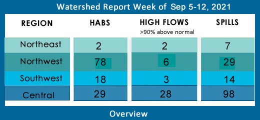
With the Flow – NYS Watershed Report for the Week of September 5-12
After Ida
By Gillian Ward
OVERVIEW
SEE BELOW FOR DETAILS
National Weather Service Hazardous Weather Warning for Wednesday Sept 8
A cold front may bring a period of heavy rainfall and thunderstorms
late Wednesday into early Thursday. There is a marginal to slight risk
of excessive rainfall/flash flooding with this system.
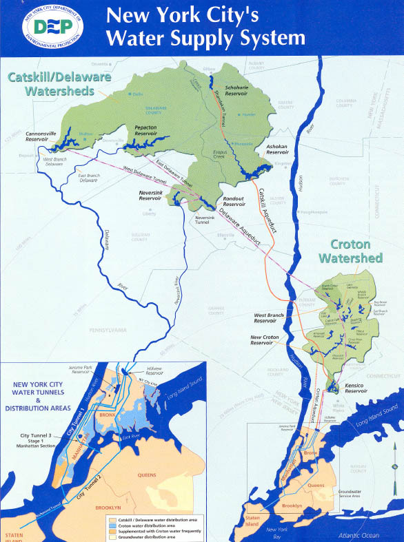
New York City’s water supply is drawn from two primary surface water source areas: the Catskill/Delaware (96%) and Croton (4%); subregions of the Delaware and Lower Hudson River Watersheds, respectively. Drinking water is collected in 19 reservoirs and three controlled lakes from a 2,000-square-mile basin. One billion gallons of safe drinking water are distributed daily to the city’s 8.3 residents, along with an additional million residents of Westchester, Putnam, Orange, and Ulster Counties. (New York City 2020 Water Quality Report)
For more information on drinking water and Severe Weather in NYC click here
Report Key:
High Flows: WTNY reports systems flowing more than 90% over mean flow rate, categorized as “much above normal” and “high”, based on USGS WaterWatch real time streamflow for Sep 6,7/21.
Visit USGS WaterWatch for realtime stream flows.
See also, National Weather Service high water terminology here https://www.weather.gov/aprfc/terminology
HABs – reporting confirmed hazardous algal blooms (cyanobacteria) confirmed as active on NYS HABs Notice, for the period Sept 3-6
Spills Report– hazardous materials spill incidents by county, listed in the pertinent watershed, as appearing in the NYS Environmental Sites Database, Spill Incidents Database as records are uploaded, covering the period Aug 30- Sep 4.
See Watershed Basics Glossary for details on each report.
Central NY Watersheds emptying into Altantic Ocean at Long Island Sound
Mohawk River Watershed
The Mohawk River originates in the western Adirondacks and the Tug Hill Plateau and flows 140 miles to the east where it joins the Hudson River. Sections of the Mohawk River also serve as the New York State Barge (Erie) Canal.
Including Schoharie Creek, West Canada Creek, East Canada Creek; Hinkley Reservoir, Delta Reservoir, Peck Lake, Schoharie Reservoir; joins the Hudson River below Albany.
High Flows: no high flows this week, the following systems are “much above normal”, over 90th percentile flow
- Schoharie Creek is flowing much above normal at Prattsville, up 860% to 2630 cfs; at North Blenheim, flowing much above normal, 190% to 532 cfs; at Breakabeen, 228% above mean at 820 cfs; at Burtonsville, 241% above mean to 991 cfs
- Mine Kill near North Blenheim has slowed this week, still much above normal at 89% above mean at 16.3 cfs
- Platter Kill at Gilboa is up 99% above mean flow at 10 cfs
HABs – none reported
Spill Report
Montgomery County:
-Equipment failure in Fultonville caused 3lbs of diesel to be spilled on an unknown resource 09/01/21, unresolved
-Equipment failure in Charleston caused 1lbs of hydraulic oil to be spilled on the soil 09/02/21, unresolved
-Other cause in Sprakers caused unknown amounts of gasoline to be spilled on an unknown resource 09/03/21, unresolved
Schoharie County:
-None reported
Upper Hudson River Watershed
The Upper Hudson River Watershed drains the south side of the Adirondack Mountains and flows south to meet the Mohawk River.
Including Sacandaga River, Schroon River, Indian River, Fish Creek, Hoosic River, Batten Kill, Great Sacandaga Lake, Indian Lake, Schroon Lake, Saratoga Lake
High Flows – all systems are below the high rating this week, the following are still rated “much above normal”
- Hudson River is still above 90th percentile at Fort Edward, 193% above mean flow, discharging 6030 cfs; at Green Island, just below the confluence with Mohawk River, flow is rated much above normal this week, still 219% above mean and less than half last week’s volume: down to 14,600 cfs from 37,700 cfs
- Indian River near Indian Lake is down slightly again this week, still flowing above normal but less than 90th percentile, 728 cfs
- Sacandaga River at Stewart’s Bridge near Hadley, flowing 231% above mean at 3890 cfs
- Hoosic River near Eagle Bridge is flowing 178% above mean and 802 cfs
- Batten Kill below Mill at Battenville is flowing much above normal, 146% above mean at 402 cfs
HABs
Sep 1 Saratoga Lake small localized bloom confirmed in Saratoga County
Aug 24,26, 27 Moreau Lake three blooms confirmed in Saratoga County remain active
Spill Report
Saratoga County:
-Other cause in Waterford caused 2 gallons of heat transfer oil to be spilled in the sewer 08/30/21, unresolved
-Traffic accident in Clifton Park caused 20 gallons of gasoline to be spilled on an unknown resource 08/31/21, unresolved
-Equipment failure in Clifton Park caused 0.25 gallons of transformer oil to be spilled on an unknown resource 09/03/21, unresolved
Washington County:
-Deliberate cause in Fort Edwards caused unknown amounts of antifreeze and motor oil to be spilled on the soil 09/01/21, unresolved
-Tank Test Failure in Hudson Falls caused unknown amounts of gasoline to be spilled on an unknown resource 09/04/21, unresolved
Warren County:
-None reported
Lower Hudson River Watershed
The Lower Hudson Watershed begins where the Mohawk River joins the Hudson system at the Troy Dam and extends down to Manhattan. The lower end of the Hudson system, 153 miles, is technically a tidal estuary, not a river.
Rondout/Wallkill Rivers, Stockport/Kinderhook Creeks, Catskill Creek, Esopus Creek, Croton River; Ashokan Reservoir, Rondout Reservoir, New Croton Reservoir, Alcove Reservoir, Cross River Reservoir, Muscoot/Upper New Croton Reservoir
High Flows: flows have slowed this week, none in high range, the following are still much above normal:
- Esopus Creek at Mount Marion is flowing much above normal, 199% above mean to 635 cfs
- Rondout Creek at Lowe’s Corners is much above normal, 287% above mean at 119 cfs, at Rosendale is much above normal, 211% above mean and discharging 677 cfs
- Walkill River at Gardiner is flowing much above normal, 703% above mean 3630 cfs
- Biscuit Bk above Pigeon Bk at Frost Valley is flowing much above normal, 117% above mean at 8.27 cfs
- Kinderhook Creek at Rossman is flowing high, up 221% to 624 cfs
- Croton River at New Croton Dam near Croton on Hudson is flowing much above normal, 883% above mean flow, discharging 1360 cfs (this monitoring station recorded 237000% above mean flow and peaked at nearly 11 ft at 8:30 am on Sept 2 in the wake of Ida.)
- Wappinger Creek near Wappinger Falls is much above normal, 380% above mean and 354 cfs
HABs
Aug 31 Sleepy Hollow Lake widespread bloom confirmed in Greene County
Aug 25 Berkshire Pond small localized bloom confirmed in Columbia County
Aug 24 Cortlandt Lake small localized bloom confirmed in Putnam County
Aug 25 Roaring Brook Lake small localized bloom confirmed in Putnam County
Aug 26 Lake Mohegan large localized bloom confirmed in Westchester County
Aug 29 Orange Lake open water bloom confirmed in Orange County, a small localized bloom confirmed Aug 25 remains active
Aug 30 Cold Spring Reservoir open water bloom confirmed in Putnam County
Aug 30 Beaver Dam Lake small localized bloom confirmed in Orange County
Spill Report
Westchester County
-Tank Test Failure in Yonkers caused unknown amounts of diesel to be spilled on an unknown resource 08/30/21, unresolved
-Unknown cause in White Plains caused unknown amounts of #4 fuel oil to be spilled on the soil 08/30/21, unresolved
-Equipment failure in Sleepyhallow caused unknown amounts of #2 fuel oil to be spilled on the soil 08/30/21, unresolved
-Equipment failure in White Plains caused 0.5 gallons of propylene to be spilled on an unknown resource 08/31/21, unresolved
-Equipment failure in Ossining caused unknown amounts of #2 fuel oil to be spilled in the soil 09/01/21, unresolved
-Equipment failure in White Plains caused unknown amounts of #2 fuel oil to be spilled in the soil 09/01/21, unresolved
-Storm in Yonkers caused unknown amounts of other material to be spilled on an unknown resource 09/01/21, resolved 09/02/21
-Unknown cause in New Rochelle caused unknown amounts of unknown petroleum to be spilled on an unknown resource 09/02/21, unresolved
-Storm in Yonkers caused unknown amounts of #2 fuel oil to be spilled on an unknown resource 09/02/21, unresolved
-Equipment failure in Pelham caused unknown amounts of #2 fuel oil to be spilled on an impervious surface 09/02/21, unresolved
-Equipment failure in Harrison caused unknown amounts of #2 fuel oil to be spilled on an unknown resource 09/02/21, unresolved
-Storm in Harrison caused unknown amounts of #2 fuel oil to be spilled on an unknown resource 09/02/21, unresolved
-Storm in Harrison caused 5 gallons of gasoline to be spilled on an unknown resource 09/02/21, unresolved
-Storm in Portchester caused unknown amounts of #2 fuel oil to be spilled on an unknown resource 09/02/21, unresolved
-Storm in Portchester caused unknown amounts of #2 fuel oil to be spilled on an unknown resource 09/02/21, unresolved
Orange County
-Traffic accident in Blooming Grove caused 5 lbs of diesel to be spilled on an unknown resource 08/30/21, resolved 08/30/21
-Unknown cause in Greenwood lake caused unknown amounts of #2 fuel oil to be spilled on the soil 08/30/21, unresolved
-Equipment failure in Campbell Hall caused unknown amounts of #2 fuel oil to be spilled on the soil 08/31/21, unresolved
-Storm in Salisbury caused unknown amounts of other material to be spilled on an unknown resource 09/01/21, unresolved
-Storm in Washington caused 50 lbs of #2 fuel oil to be spilled on an unknown resource 09/02/21, unresolved
-Storm in Washington caused 5 gallons of transformer oil to be spilled on the soil 09/02/21, resolved 09/02/21
-Storm in Montgomery caused 3 gallons of transformer oil to be spilled in the soil 09/02/21, resolved 09/03/21
-Storm in Monroe caused unknown amounts of paper and raw sewage to be spilled on an unknown resource 09/03/21, resolved 09/03/21
Putnam County
-Equipment failure in Brewster caused unknown amounts of waste oil to be spilled on an unknown resource 08/30/21, unresolved
-Equipment failure in Putnam valley caused unknown amounts of #2 fuel oil to be spilled on the soil 09/02/21, unresolved
-Unknown cause in Mahopac caused unknown amounts of raw sewage to be spilled on the unknown resource 09/02/21, resolved 09/03/21
-Equipment failure in Brewster caused 45 gallons of hydraulic oil to be spilled on an unknown resource 09/03/21, resolved 09/03/21
-Storm in Brewster caused unknown amounts of diesel to be spilled in surface water 09/04/21,
Columbia County
-Equipment failure in Hudson caused 1.5 gallons of non PCB oil to be spilled in the soil 08/30/21, unresolved
-Equipment failure in Hudson caused 5 gallons of transmission fluid to be spilled in the soil 08/30/21, unresolved
-Storm in Claverack caused 5 gallons of transformer oil to be spilled on an unknown resource 09/02/21, unresolved
Delaware River Watershed
The headwaters flow down from the Catskill Mountains into Delaware Bay/Atlantic Ocean. The watershed area includes East Branch Delaware River, West Branch Delaware River, Neversink River, Mongaup River, Pepacton Reservoir, Cannonsville Reservoir and Neversink Reservoir.
High Flows:
- West Branch Delaware at Walton is flowing much above normal, 154% above mean, 440 cfs
- East Branch Delaware at Fishs Eddy is flowing much above normal, 130% above mean at 1130 cfs
- Beaver Kill at Cooks Falls is much above normal, 190% above mean and 551 cfs
- Neversink River at Godeffroy is flowing much above normal, 267% above mean at 889cfs
- Delaware River at Port Jervis is much above normal, flowing 208% above mean at 6740 cfs
- Callicoon Creek at Callicoon is flowing much above normal this week, 440% above mean at 171 cfs
HABS:
Aug 30 Swinging Bridge Reservoir new bloom confirmed in Sullivan County, the extent is not reported
Spill Report:
Sullivan County
-Unknown cause in Liberty caused unknown amounts of raw sewage to be spilled on an unknown resource 08/30/21, resolved 08/30/21
-Equipment failure in Monticello caused 10 gallons of hydraulic oil to be spilled on the soil and surface water 09/01/21, unresolved
-Deliberate cause in Rockhill caused unknown amounts of gasoline to be spilled on an unknown resource 09/03/21, resolved 09/03/21
-Storm in Glen Spey caused 20 gallons of transformer oil to be spilled in the soil 09/03/21, resolved 09/03/21
-Equipment failure in White Lake caused unknown amounts of raw sewage to be spilled in the surface water 09/03/21, resolved 09/03/21
Delaware County
-Equipment failure in Meridale caused unknown amounts of raw sewage to be spilled in the soil 09/02/21, resolved 09/03/21
Ulster County
-Equipment failure in Woodstock caused 5 gallons of transformer oil to be spilled on an unknown resource 08/30/21, unresolved
-Storm in Kingston caused 50 gallons of raw sewage to be spilled in the sewer and impervious surface 09/02/21, resolved 09/02/21
-Deliberate cause in Gardiner caused 50 gallons of #2 fuel oil to be spilled in the soil 09/02/21, unresolved 09/03/21
-Traffic accident in Bearsville caused 5 gallons of transformer oil to be spilled on an unknown resource 09/02/21, unresolved
Housatonic River Watershed
A small portion of the headwaters of the Housatonic lie in eastern New York State. These waters drain the Taconic and Berkshire Mountains before joining the Housatonic and eventually emptying into Long Island Sound. Includes Tenmile River, Green River, Indian Lake, Swift/Crane Ponds
High Flow: none in high range, the following are flowing above 90th percentile, “much above normal”
- Green River near Great Barrington is 207% above mean flow at 147 cfs
- Housatonic River at Great Barrington is reporting 317% above mean flow and 698 cfs this week
HABs: none reported
Spill Report:
Dutchess County
-Storm in Pleasant Valley caused 5 gallons of transformer oil to be spilled on the soil 09/02/21, unresolved
-Equipment failure in Amenia caused unknown amounts of unknown petroleum to be spilled on an unknown resource 09/02/21, unresolved
-Storm in Hopewell Junction caused unknown amounts of #2 fuel oil to be spilled in the soil 09/02/21, unresolved
-Storm in Rhinebeck caused 7 gallons of transformer oil to be spilled on an unknown resource 09/02/21, unresolved
-Equipment failure in Millerton caused 1 gallon of transformer oil to be spilled on the soil 09/02/21, resolved 09/02/21
-Unknown cause in Fishkill caused unknown amounts of diesel to be spilled on an unknown resource 09/04/21
Ramapo River Watershed
The northern headwaters of the Passaic basin lie within a small portion of southeastern New York State, including the Ramapo and Hackensack Rivers drainage areas. It is the smallest watershed in New York State. Including Ramapo River, Hackensack River, Greenwood Lake, DeForest Lake.
High Flow:
- Ramapo River at Suffern is flowing 230% above mean at 280 cfs
- Mahwah River near Suffern is flowing much above normal, 250% above mean at 27 cfs
HABs:
Aug 21 Little We Wah Lake small localized bloom confirmed in Orange County
Spills Report
Rockland
-Unknown cause in Orangeburg caused unknown amounts of #2 fuel oil to be spilled in the sewer 08/31/21, unresolved
-Equipment failure in Ramapo caused unknown amounts of transformer oil to be spilled in the soil 08/31/21, resolved 08/31/21
-Unknown cause in Palisades caused unknown amounts of unknown petroleum to be spilled on an unknown resource 08/31/21, unresolved
-Equipment failure in New Square caused 1 gallon of transformer oil to be spilled on an unknown resource 09/01/21, resolved 09/01/21
-Storm in Tompkins cove caused unknown amounts of transformer oil to be spilled on an unknown resource 09/02/21, unresolved
-Storm in Piermont caused 5 gallons of transformer oil to be spilled on an unknown resource 09/02/21, resolved 09/07/21
Atlantic Ocean/Long Island Sound Watershed
The Atlantic Ocean/Long Island Sound Watershed drains most of the New York City Metropolitan Area and all of Long Island. The drainage area includes all marine waters in New York Harbor, Long Island Sound, Block Island Sound, and along the South Shore of Long Island, and the fresh waters that drain into them.
Includes 1415 square miles of marine estuary waters, the Bronx River, Mamaroneck River, Mianus River, Peconic River, Kensico Reservoir, Lake Ronkonkoma.
High Flow:
- Sampawams Creek at Babylon is flowing high this week, 317% above mean, 20.3 cfs
- Mill Neck Creek at Mill Neck is flowing much above normal, 139% above mean at 11 cfs
- Swan River at East Patchogue is flowing much above normal, 134% above mean and 14.2 cfs
HABs
Sep 3 Agawam Lake widespread bloom confirmed in Suffolk County, Aug 24 bloom remains active also
Aug 31 Sagg Pond new bloom confirmed, the Aug 24 lakewide bloom is still active
Aug 31 Wainscott Pond widespread bloom confirmed in Suffolk County, the Aug 24 bloom remains active
Aug 29 Little Fresh Pond open water bloom confirmed in Suffolk County
Aug 31 Great Pond bloom confirmed in Suffolk County, the extent is not reported
Fort Pond, two records of widespread/lakewide blooms reported Aug 24 remain active in Suffolk County
Mill Pond (Watermill) widespread/lakewide bloom confirmed Aug 24 in Suffolk County remains active
Hallocks Pond, first time this season, large localized bloom confirmed in Suffolk County Aug 26 remains active
The Lake In Central Park widespread bloom confirmed in Manhattan Aug 30 remains active
Turtle Pond large localized bloom confirmed in Manhattan Aug 24 remains active
Prospect Park Lake widespread/lakewide bloom confirmed in Kings County Aug 26 remains active
Spill Report:
Kings (Brooklyn)
-Other cause in Brooklyn caused unknown amounts of other material to be spilled on an unknown resource 08/30/21, resolved 09/01/21
-Unknown cause in Brooklyn caused 2 gallons of gasoline to be spilled in the soil 08/31/21, unresolved
-Other cause in Brooklyn caused 8 gallons of #2 fuel oil to be spilled on an unknown resource 08/31/21, resolved 09/01/21
-Equipment failure in Brooklyn caused 25 gallons of unknown petroleum to be spilled on an unknown resource 09/01/21, unresolved
-Equipment failure in Brooklyn caused 2 gallons of transformer oil to be spilled on an unknown resource 09/02/21, unresolved
-Storm in Brooklyn caused unknown amounts of gasoline to be spilled on an unknown resource 09/04/21, resolved 09/07/21
Queens County
-Other cause in Elmhurst caused unknown amounts of paint spray to be spilled into the air 09/01/21, resolved 09/01/21
-Storm in Queens caused unknown amounts #2 fuel oil to be spilled on an unknown resource 09/02/21, unresolved
-Storm in Queens caused 2 gallons of transformer oil to be spilled on the soil 09/02/21, unresolved
-Equipment failure in Long Island caused 1 gallon of other material to be spilled on an unknown resource 09/03/21, unresolved
Nassau County
-Equipment failure in Bellmore caused 20 gallons of #2 fuel oil to be spilled on an unknown resource 08/30/21, unresolved
-Equipment failure in Massapequa caused unknown amounts of unknown petroleum to be spilled in the surface water 08/30/21, unresolved
-Equipment failure in Levittown caused unknown amounts of #2 fuel oil to be spilled on the soil 08/301/21, unresolved
-Equipment failure in Lawrence caused 5 gallons of transformer oil to be spilled on an unknown resource 08/31/21, unresolved
-Equipment failure in East Meadow caused 1 gallon of transformer oil to be spilled on the soil 08/31/21, unresolved
-Human error in Farmingdale caused 10 gallons of diesel to be spilled in the soil and sewer 09/01/21, unresolved
-Traffic accident in Westbury caused unknown amounts of #2 fuel oil to be spilled in the soil 09/01/21, unresolved
-Storm in Glen Cove caused 10 gallons of unknown petroleum to be spilled on an unknown resource 09/02/2021, unresolved
Suffolk County
-Equipment failure in Fire Island Pines caused 2 gallons of transformer oil to be spilled on the soil 08/30/21, unresolved
-Equipment failure in Quiogue caused unknown amounts of #2 fuel oil to be spilled on an unknown resource 08/30/21, unresolved
-Abandoned drums in Mastic Beach caused 5 gallons of unknown petroleum to be spilled in the soil and surface water 08/30/21, unresolved
-Equipment failure in Commack caused unknown amounts of diesel to be spilled on an unknown resource 08/31/21, unresolved
-Equipment failure in Remsenburg caused unknown amounts of diesel to be spilled on the soil 09/01/21, unresolved
-Equipment failure in West Babylon caused unknown amounts of #2 fuel oil to be spilled on the soil 09/02/21, unresolved
-Equipment failure in Ridge caused 2 gallons of transformer oil to be spilled in the soil 09/02/21, unresolved
-Equipment failure in Eatons Neck caused 4 gallons of transformer oil to be spilled in the soil and impervious surface 09/02/21, unresolved
Richmond County
-Storm in Staten Island caused unknown amounts of transmission fluid and motor oil to be spilled on an unknown resource 09/02/21, unresolved
-Storm in Staten Island caused unknown amounts of #2 fuel oil to be spilled on an unknown resource 09/02/21, unresolved
Bronx County
-Deliberate cause in Bronx caused unknown amounts of motor oil to be spilled on an unknown resource 08/31/21, resolved 08/31/21
-Unknown cause in the Bronx caused unknown amounts of gasoline to be spilled on the soil 08/31/21, resolved 09/01/21
-Unknown cause in the Bronx caused unknown amounts of unknown petroleum to be spilled on the soil 09/01/21, unresolved
-Storm in the Bronx caused 100 lbs of dielectric fluid to be spilled in the soil 09/02/21, unresolved
-Storm in the Bronx caused 4 gallons of #2 fuel oil to be spilled on an unknown resource 09/02/21, unresolved
-Storm in the Bronx caused 300 gallons of phosphoric acid to be spilled on an unknown resource 09/02/21, resolved 09/07/21
Northeast Watersheds– emptying into Atlantic Ocean via St. Lawrence River
Lake Champlain Watershed –
The Lake Champlain Watershed drains the area between the Adirondack Mountains in northeastern New York State and the Green Mountains in northwestern Vermont.
Includes the Ausable River, Saranac River, Great Chazy River, Boquet River, Mettawee River, Ticonderoga Creek/Lake George, Lake George,
Upper Saranac Lake, Lower Saranac Lake, Lake Placid, Lake Champlain
High Flows: all within normal range or below normal, less than 90th percentile
HABs:
Lake Champlain Basin Program is a multi-jurisdiction cooperative effort to protect water quality, funded by federal EPA, Vermont, New York state and Province of Quebec departments of Health and Environment.
Lake Champlain Basin
Lake Champlain small localized bloom confirmed in Essex County Aug 25 remains active status.
Check local conditions for the day of your visit, cyanobacteria blooms conditions change rapidly. For more information see the 2021 State of the Lake Report, or visit lcbp.org
Spill Report:
Clinton County
-Other cause in Plattsburgh caused unknown amounts of waste oil to be spilled on an unknown resource 09/02/21, unresolved
Essex County
-Equipment failure in Ray Brook caused unknown amounts of diesel to be spilled on an unknown resource 08/30/21, unresolved
Black River Watershed – Filters and drains most of Jefferson and Lewis Counties along with parts of Herkimer, Hamilton and Oneida Counties.
Major tributaries in the system include Moose River, Beaver River, Independence River and Deer River, Stillwater Reservoir, Fulton Chain of Lakes, Lake Lila and Big Moose Lake.
High Flows:
Beaver River at Croghan is flowing much above normal, 156% above mean flow at 762 cfs.
Black River has slowed at its outlet to Lake Ontario, still above normal at 133% above mean flow, discharging 2360 cfs, down from a peak flow of 15,700 cfs two weeks ago.
HABs –
Aug 28 Lake Ontario large localized bloom confirmed in Jefferson County remains on active list.
Spill Report :
Jefferson County
-Traffic accident in Fort Drum caused unknown amounts of anti freeze to be spilled on an unknown resource 09/01/21, unresolved
-Unknown cause in Alexandria Bay caused 0.25 gallons of motor oil to be spilled on surface water 09/03/21, resolved 09/03/21
Lewis County
-None reported
St. Lawrence River Watershed -
185 km of the St. Lawrence River catches the runoff from the northern and western Adirondack Mountains, drawing from portions of eight states, a combined area of 5600 square miles.
St. Lawrence Watershed collects the flow from eleven thousand miles of freshwater rivers and streams, including the Oswegatchie River, Raquette River, Saint Regis River, Grass River and Indian River; including Black Lake, Cranberry Lake, Raquette Lake, Tupper Lake and Long Lake. Densely forested woodlands, peatlands and areas of flat agricultural plains make up the natural surface water filtration system of this watershed area.
High Flows:
- Raquette River at Piercefield is still flowing much above normal, slowing from last week, but still 193% above mean and discharging 1050 cfs; the rest of the system is flowing in normal range, less than 90th percentile above normal.
HAB’s report: none reported
Spill Report
Franklin County
-None reported
St. Lawrence County
-Traffic accident in Hammond caused unknown amounts of diesel to be spilled on an unknown resource 08/31/21, unresolved
-Equipment failure in Oswegatchie caused unknown amounts of gasoline to be spilled on an unknown resource 09/01/21, unresolved
-Equipment failure in Ogdensburg caused unknown amounts of raw sewage to be spilled in the soil 09/03/21, resolved 09/03/21
Northwest Watersheds – empties into Atlantic Ocean via Great Lakes and St. Lawrence River
Lake Ontario and Minor Tributaries
This watershed includes the areas between the larger rivers that drain into Lake Ontario. It is divided into western, central and eastern sections that stretch all along the Lake Ontario Shoreline.
*Includes Salmon River Reservoir, Sodus Bay, North Pond, Irondequoit Bay and Perch Lake; Salmon River, Oak Orchard Creek, Irondequoit Creek, Sandy Creek
High Flows:
- Oswego River is flowing much above normal this week at Oswego Lock 7, 215% above mean flow, slowing to 5330 from a high of 21,700 cfs two weeks ago.
- Seneca River near Baldwinsville has slowed this week, still over 90th percentile: 260% above mean at 9020 cfs
- Sandy Creek at Adams is still flowing much above normal this week, 1057% above mean to 444 cfs
HABs:
Lake Neatahwanta widespread/lakewide bloom confirmed in Fulton County on Aug 24 is still active.
Spill Report
Orleans County
-None reported
Wayne County
-None reported
Oswego County
-None reported
Niagara River/Lake Erie Watershed
The Niagara River drains an area encompassing more than 265,000 square miles in the north central United States and south central Canada, including Tonawanda Creek, Cattaraugus Creek, Buffalo River; Attica Reservoir and Lime Lake.
High Flows: all flows under 90th percentile this week, normal or above normal range
HABs:
Aug 28 Java Lake open water bloom confirmed in Wyoming County
Aug 29 Eighteenmile Creek small localized bloom confirmed in Erie County
Spill Report
Erie County
-Other cause in East Aurora caused 3 gallons of transformer oil to be spilled on an unknown resource 08/30/21, resolved 08/31/21
-Equipment failure in Buffalo caused 10 gallons of hydraulic oil to be spilled on an impervious surface 08/31/21, unresolved
-Unknown cause in Buffalo caused unknown amounts of gasoline to be spilled on the soil 08/31/21, unresolved
-Equipment failure in Buffalo caused 1 gallon of transformer oil to be spilled on an unknown resource 09/01/21, resolved 09/01/21
-Equipment failure in Buffalo caused 7 gallons of gasoline to be spilled on an impervious surface 09/02/21, resolved 09/02/21
-Equipment failure in Buffalo caused 180 gallons of transformer oil to be spilled on an unknown resource 09/02/21, unresolved
Niagara County
-Equipment failure in Middleport caused 25 gallons of non PCB oil to be spilled on an unknown resource 08/30/21, unresolved
-Unknown cause in Niagara Falls caused unknown amounts of gasoline to be spilled on the soil 09/01/21, unresolved
-Traffic accident in Gasport caused unknown amounts of diesel and motor oil to be spilled in the soil 09/03/21, unresolved
Oswego River and Finger Lakes Watershed
Including Otisco, Skaneateles, Owasco, Cayuga, Oneida, Seneca, Keuka, Canandaigua and Canadice Lakes; Oneida River, Clyde River, Cayuga Lake Tributaries and Seneca Lake Tributaries
High Flow: all in normal range or below normal, under 90th percentile flows.
HABs: With a peak number of HABs reported last week at 110, the region has recovered to this week’s total of 68 active blooms.
Aug 31 Waneta Lake small localized bloom confirmed in Schuyler County
Aug 30 Skaneateles Lake, 23 active HABs including small and large localized blooms, lakewide blooms confirmed in Onandaga and Cayuga Counties
Aug 25, 26-30 Cayuga Lake, 12 active HABS confirmed in Cayuga and Tompkins Counties
Aug 30 Owasco Lake 15 active blooms confirmed, small and large localized confirmed in Cayuga County
Aug 30 Canandaigua Lake, 11 active HABs confirmed this week, including small and large localized blooms confirmed in Ontario County
Aug 26-30 Seneca Lake, 6 active blooms confirmed in Schuyler and Yates Counties
Check local conditions before venturing out to the lakes this week, HABs appear rapidly and toxins may remain in the water for a period after the bloom is gone.
WaterToday reached out to NYS Department of Environmental Conservation to find out more about the prevalence of HABs in Oswego/Finger Lakes, why this region is so heavily infiltrated with HABs and what is being done to mitigate the loss of recreational opportunities in the area. Here is the reply we received:
FOR ATTRIBUTION TO DEC
“Safeguarding New York's water quality is a top priority and the State is providing direct assistance to communities to reduce the frequency of harmful algal blooms (HABs). Department of Environmental Conservation (DEC) and Health (DOH) experts are working closely with state and local partners to investigate the causes of HABs across the state and are pioneering cutting edge solutions to respond to these blooms and the threats they pose to public health and the environment, namely New York's drinking water supplies. In 2018, New York hosted four summits to bring together national, state, and local experts to discuss how to reduce the frequency of these blooms.
To date, New York has awarded more than $187 million in grants to projects designed to reduce the frequency of algal blooms by targeting phosphorus and nitrogen pollution, factors that trigger HAB occurrences. In collaboration with partners, DEC is advancing over $11 million to research and development, pilot projects, and advanced monitoring to address HABs. Additionally, advanced monitoring for nutrient drivers and HABs indicators has been conducted in 175 lakes.
New York State's Water Quality Rapid Response Team, national experts and local stakeholders collaboratively developed Harmful Algal Bloom (HAB) Action Plans for 12 priority lakes that are vulnerable to HABs, critical sources of drinking water, and vital tourism drivers. These lakes were chosen as part of New York State's HAB initiative because they represent a wide range of conditions and vulnerabilities, and the lessons learned will be applied to other impacted waterbodies moving forward. HAB Action Plans were prepared on an accelerated basis by DEC in close coordination with local steering committees. Each action plan identifies contributing factors fueling HABs and immediate actions that can be taken to reduce the sources of pollution that spark algal blooms.
ON BACKGROUND
HABs occurrences in the Finger Lakes are not uncommon this time of year. Peak HABs season in New York runs from late August through early September. Many of the Finger Lakes have extensive monitoring networks including volunteers trained to look for HABs and report them to DEC through our NYHABs portal (see below). At the end of the season, DEC will be able to better assess and compare this year to prior years.
Legacy nutrients can take decades to clear from these large lakes. The HABs we are seeing today are likely feeding off nutrients that ran off the landscape many years ago. The impact of invasive Quagga mussels on bloom concentration in the Finger Lakes is a complicated theory currently being studied by many researchers around the world. Specifically, each lake's action plan includes:
Lake Background
Designated Uses
User and Stakeholder Groups
Monitoring Efforts
Water Quality Conditions
Summary of HABs in the Lake
Waterbody Assessment
Conditions Triggering HABs
Sources of Pollutants
Lake Management / Water Quality Goals
Summary of Management Actions to Date
Proposed HABs Actions
Links to Harmful Algal Bloom Action Plans for Owasco, Cayuga and Skaneateles are below:
Owasco Lake Harmful Algal Bloom Action Plan (PDF)
Cayuga Lake Harmful Algal Bloom Action Plan (PDF)
Skaneateles Lake Harmful Algal Bloom Action Plan (PDF)
What factors are contributing to these blooms, and can they be mitigated?
HABs are likely triggered by a combination of water and environmental conditions that may include excess nutrients (phosphorus and nitrogen), lots of sunlight, low-water or low-flow conditions, calm water, and warm temperatures. Depending on the weather and the characteristics of the lake, HABs may be short-lived (appearing and disappearing in hours) or long-lived (persisting for several weeks or more). While the exact cause of HABs is not fully understood, HABs usually occur in waters high in phosphorus and/or nitrogen. New York State has many programs and activities to reduce phosphorus and nitrogen from entering the water from surrounding lands, including stormwater permitting programs, funding for water quality improvement projects, and a nutrient law that restricts the use of phosphorus lawn fertilizer. Please find additional info on from DEC’s website: Harmful Algal Blooms (HABs).
How does the state conduct testing of the water for dissolved toxins?
DEC and DOH partnered to establish the most comprehensive HAB surveillance and alert program in the country. In June 2019, New York State launched a new online HABs map and reporting system for the public. NYHABS reporting system features an interactive map that is updated daily with reports of HABs, as well as a new public reporting form. This system relies on visual reporting to allow for near real-time notification of the public regarding where HABs are occurring.
The DEC Citizen Statewide Lake Assessment Program and the Lake Classification and Inventory Program contributed extensively to HABs reporting. In addition, as in previous years, DOH, the Office of Parks, Recreation and Historic Preservation, SUNY ESF, Stony Brook University, NYC Department of Parks and Recreation, and other agencies and organizations were instrumental in documenting HABs in New York in 2020. Approximately 800 volunteers help to monitor and report HABs in New York State.
DEC encourages New Yorkers to “KNOW IT, AVOID IT, REPORT IT.” KNOW IT – naturally occurring harmful algal blooms, ‘HABs,’ vary in appearance from scattered green dots in the water, to long, linear green streaks, pea soup or spilled green paint, to blue-green or white coloration. AVOID IT – People, pets and livestock should avoid contact with water that is discolored or has algal scums on the surface. REPORT IT – If members of the public suspect a HAB, report it through the NYHABs online reporting form available on DEC’s website.
HABs can cause health effects in people and animals when water with blooms is touched, swallowed, or when airborne droplets are inhaled. For more information please visit NYS Department of Health's HAB page. Symptoms or health concerns related to HABs should be reported to DOH at harmfulalgae@health.ny.gov. The public is encouraged to contact the local health department with any reports of health effects (human or animal).
DEC HABs Brochure http://www.dec.ny.gov/docs/water_pdf/habsbrochure.pdf and FAQs http://www.dec.ny.gov/chemical/91570.html
Summary of 2020 Harmful Algal Bloom (HAB) Notification Season
DEC has posted a summary of the 2020 Harmful Algal Bloom (HAB) notices to the HABs Archive webpage. During 2020, 184 waterbodies statewide were listed on the NY HABs System (NYHABS). Nearly 2,000 HAB reports were collected by DEC and its partners, and of these, over 900 met DEC criteria for a HAB. The reports ranged from a single observation to widespread blooms that were persistent throughout the season.
Historical data is available on Open NY (Search the catalog for "Harmful Algal Blooms"). Also, the 2012-2019 HABs Archive Summary includes HAB reports since DEC began the HABs Program.
Cayuga Lake draft Total Maximum Daily Load (TMDL)
Earlier this year, working with state and local partners, DEC proposed a nutrient pollution-reduction “budget” for Cayuga Lake to help protect drinking water quality and restore the lake’s southern end for recreation. This budget for the lake—a draft Total Maximum Daily Load (TMDL)—provides a detailed, scientific analysis of phosphorus pollutant sources and recommends a 30 percent reduction of phosphorus loads to the Cayuga Lake watershed. The draft TMDL incorporates years of research, modeling, and water quality analyses to bolster strategies to reduce nutrients in the watershed.
Since 2017, New York State has invested more than $6 million in water quality improvements in Cayuga Lake’s watershed through the Water Quality Improvement Project program and other programs. Completed projects include streambank stabilizations, septic maintenance and pump-out, stormwater mapping in Municipal Separate Storm Sewer System (MS4) areas, and installation of agricultural best management practices.
Backed by billions of dollars in investments, New York State is fiercely committed to protecting water quality. We’ve made remarkable progress in combatting HABs, but we know our work is not done. With partners at all levels of government, academia, and industry, New York is pioneering cutting-edge solutions to respond to these blooms and the threats they pose to public health and the environment.”
Spill Report:
Seneca County
-None reported
Onondaga County
-Traffic accident in Pompey caused unknown amounts of hydraulic oil to be spilled in the sewer 08/30/21, unresolved
-Traffic accident in Cicero caused 300 gallons of diesel to be spilled on the soil 08/30/21, unresolved
-Traffic accident in Syracuse caused 15 gallons of gasoline to be spilled on an unknown resource 08/30/21, resolved 08/31/21
-Equipment failure in Syracuse caused 10 gallons of diesel to be spilled on an unknown resource 08/31/21, unresolved 08/31/21
Cayuga County
-Traffic accident in Cato caused 10 gallons of diesel to be spilled on the soil 09/01/21, unresolved
Schuyler County
-None reported
Yates County
-Human error in Brachport caused unknown amounts of paint to be spilled in the sewer 08/30/21, unresolved
Ontario County
-Equipment failure in Canadaigua caused 0.25 gallons of hydraulic oil to be spilled in the soil 08/30/21, resolved 08/31/21
-Equipment failure in Richmond caused unknown amounts of #2 fuel oil to be spilled in the soil 09/01/21, unresolved
-Traffic accident in Palmyra caused unknown amounts of antifreeze and motor oil to be spilled in the soil 09/02/21, unresolved
-Human error in Stanley caused 500 gallons of diesel to be spilled on an unknown resource 09/02/21, unresolved
Genesee River Watershed
Including: Conesus Lake, Silver Lake, Mount Morris Reservoir, Hemlock Lake, Honeoye Lake; Cassadaga Creek, Honeoye Creek, Oatka Creek, Black Creek
High Flows:
- Genesee River at at Wellsville is back down to normal range from last week’s peak near flood stage; at Portageville is flowing much above normal at 208% above mean, down to 553 cfs; at Ford Street Bridge, Rochester back to normal flows
- Honeoye Creek at Honeoye Falls is still flowing much above normal, 287% above mean at 27 cfs
- Conesus Creek near Lakeville is flowing much above normal at 192% above mean, 24 cfs
HABs:
Aug 26-30 Honeoye Lake, 7 active HABs reported, including small and large localized blooms, open water and widespread blooms confirmed in Ontario County
Spill Report:
Livingston County
-Traffic accident in Springwater caused 1.25 gallons of motor oil to be spilled on the soil and in surface water 08/31/21, unresolved
-Equipment failure Sparta caused unknown amounts of hydraulic oil to be spilled on an impervious surface 09/01/21, unresolved
Allegany County
-None reported
Monroe County
-Equipment failure in Perinton caused unknown amounts of antifreeze to be spilled on the soil and ground water 08/31/21, unresolved
-Equipment failure in Rochester caused 5 gallons of diesel to be spilled on an impervious surface 08/31/21, unresolved
-Equipment failure in Rochester caused 7 gallons of other material to be spilled on an unknown resource 08/31/21, unresolved
-Traffic accident in Webster caused 5 gallons of transformer oil to be spilled on the soil and impervious surface 09/01/21, resolved 09/01/21
-Unknown cause in Chili caused unknown amounts of lube oil and unknown petroleum to be spilled on the soil and ground water 09/01/21, unresolved
-Equipment failure in Webster caused 20 gallons of hydraulic oil to be spilled on an unknown resource 09/02/21, unresolved
-Equipment failure in Henrietta caused 10 gallons of hydraulic oil to be spilled on an unknown resource 09/03/21, unresolved
Genesee County:
-Equipment failure in Pembroke caused 15 gallons of diesel to be spilled on an unknown resource 09/03/21, unresolved
Wyoming County:
-None reported
Southwest Watersheds – Allegheny, emptying into Gulf of Mexico via Ohio River/Mississippi River; Chemung and Susquehanna emptying into Atlantic Ocean via Chesapeake Bay
Allegheny River Watershed (flowing west into Ohio River system)
Including Allegheny River, Chadakoin River, Conewango Creek, Canaseraga Creek, Cassadaga Creek, Olean Creek, Great Valley Creek, French Creek, Allegheny Reservoir, Chautauqua Lake
High Flows: flows have returned to normal
HABs:
Sep 3 Quaker Lake large localized bloom confirmed in Cattaraugus County
Aug 27- Sep 3 Chautauqua Lake 11 active HABs confirmed, from small to large localized blooms in Cattaraugus County
Allegheny Reservoir, 2 new large localized blooms confirmed in Cattaraugus County remain active
Red House Lake small localized bloom confirmed in Cattaraugus County Aug 24 remains active
Spill Report:
Cattaraugus County
-Traffic accident in Cattaraugus caused 500 gallons of milk to be spilled in the soil 09/01/21, unresolved
Chautauqua County
-None reported
Chemung River Watershed
The Chemung River flows across the western portion of Southern Tier of New York State before joining the Susquehanna River and eventually emptying into the Chesapeake Bay.
Including Cohocton River, Tioga/Canisteo River; Lamoka Lake/Mill Pond, Waneta Lake, Almond Lake
High Flows:
- Canisteo River at West Cameron is still flowing above 90th percentile, 192% above mean at 95 cfs, all other stations below 90th percentile
- Cohocton River near Campbell is flowing much above normal, 273% above mean at 274 cfs
HABs: none reported
Spill Report:
Chemung County
-None reported
Steuben County
-Unknown cause in Canisteo caused unknown amounts of manure to be spilled on an unknown resource 08/30/21, unresolved
-Traffic accident in Painted Post caused unknown amounts of motor oil to be spilled on an unknown resource 09/01/201, unresolved
-Equipment failure in Hammond Sport caused 2 gallons of transformer oil to be spilled on the soil and impervious surface 09/02/21, unresolved
Susquehanna River Watershed
The Susquehanna River drains 27,500 square miles covering large parts of New York, Pennsylvania and Maryland before emptying into the Chesapeake Bay.
Including: Chenango River, Tioughnioga River, Unadilla River, Owego Creek; Otsego Lake, Canadarago Lake, Whitney Point Lake/Reservoir
High Flows
- Susquehanna River at Unadilla is flowing over 90th percentile, 226% above mean at 757 cfs; at Conklin 181% above mean at 1920 cfs and at Vestal is much above normal, 138% above mean at 3280 cfs
HABs –
Aug 24 Guilford Lake open water bloom confirmed in Chenango County
Aug 28, 29 Thunder Lake 2 widespread/lakewide blooms reported in Chenango County
Spill Report:
Broome County
-Equipment failure in Windsor caused unknown amounts of motor oil to be spilled on an unknown resource 08/31/21, unresolved
-Equipment failure in Binghamton caused 10 gallons of diesel to be spilled on an impervious surface 08/31/21, resolved 09/01/21
-Unknown cause in Vestal caused unknown amounts of unknown material to be spilled on an unknown resource 09/01/21, resolved 09/02/21
-Traffic accident in Lisle caused 100 gallons of gasoline to be spilled on an unknown resource 09/03/21, unresolved
-Traffic accident in Binghamton caused unknown amounts of unknown petroleum, and 2 gallons of antifreeze to be spilled in the soil and surface water 09/04/21, resolved 09/07/21
Chenango County
-Human error in New Berlin caused unknown amounts of diesel to be spilled on an unknown resource 08/30/21, unresolved
Cortland County
-None reported
Otsego County
-Tank Test Failure in Gilbertsville caused unknown amounts of wastewater to be spilled on an unknown resource 08/30/21, unresolved
-Equipment failure in Cooperstown caused unknown amounts of #2 fuel oil to be spilled on the soil 09/01/21, unresolved
-Equipment failure in Richfield Springs caused unknown amounts of hydraulic oil to be spilled on an unknown resource 09/03/21, unresolved
Tioga County
-None reported
|