|
|

|
  
2021/8/6
Watershed Report
With the Flow – NYS Watershed Report for the Week of August 2 to 8
By Gillian Ward
High Flows **All NYS monitoring stations below flood stage**
WYNY reports flows more than 90% over mean “much higher than normal” and “high” flows.
HABs – all confirmed blooms of active status are reported
Spills – see the Watershed Basics Glossary for spills that must be reported, who must report a spill, etc.
WTNY publishes the reported hazardous materials spill incidents by county, in the pertinent watershed.
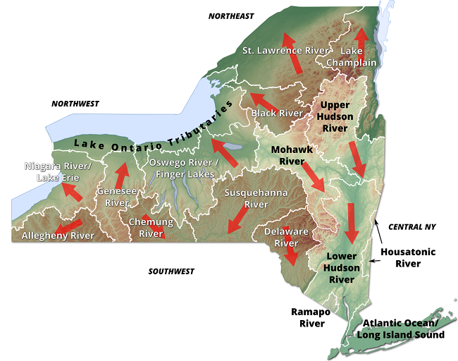
Northeast Watersheds– emptying into Atlantic Ocean via St. Lawrence River
Lake Champlain Watershed
The Lake Champlain Watershed drains the area between the Adirondack Mountains in northeastern New York State and the Green Mountains in northwestern Vermont. The long, narrow and deep lake runs out the north end through the Richelieu River and empties into the Saint Lawrence River.
Includes the Ausable River, Saranac River, Great Chazy River, Boquet River, Mettawee River, Ticonderoga Creek/Lake George, Lake George, Upper Saranac Lake, Lower Saranac Lake, Lake Placid
High Flows
Flow rates are down all through the watershed this week, with none reported in the high category.
Systems flowing above the 90th percentile, “much greater than normal”:
- Saranac River is 184% above mean flow discharging 978 cfs at Plattsburg
HABs Report
Lake Champlain: large and small localized blooms confirmed Jul 19, 20 and 21 still active HABs:
- in Essex County at the south end of the lake remain on the record of active HABs.
- several large localized blooms south of Keeseville on the west side of the lake remain active status this week
- three large localized blooms in Clinton County, north of Plattsburg on the west side of the lake remain active status HABs
Spill Report
Clinton County
>Jul 29 A traffic accident in Saranac at Route 3 and Hardscrabble Rd, saw 15 gallons of diesel spilled to hardtop and surface water, record remains open.
Essex County:
Jul 28 Ticonderoga deliberate release of 2 gallons of fuel into Lake George, the record is open
Jul 29 commercial incident in 2500 block of Main St Lake Placid resulted in release of an unknown contaminant, unknown amount to unknown resource. The record is still open.
Black River Watershed
Filters and drains most of Jefferson and Lewis Counties along with parts of Herkimer, Hamilton and Oneida Counties. Major tributaries in the system include Moose River (872 miles) Beaver River (624 miles) Independence River (207 miles) and Deer River (201 miles), including Stillwater Reservoir (6195 lake/reservoir acres), Fulton Chain of Lakes (4310 acres), Lake Lila (1,414 acres) and Big Moose Lake (11,286 acres).
Contact for Black River Regulating District: (518)465-3491 or email hrao@hrbrrd.ny.gov
High Flows
Black River is flowing above the 90th percentile at Watertown, up 249% above mean flow, 4820 cfs
HABs Report – none reported
Spill Report
Jefferson County – see Lake Ontario Minor Tributaries
Lewis County - no spills reported for the period
St. Lawrence River Watershed -
185 km of the St. Lawrence River catching the runoff from the northern and western Adirondack Mountains, drawing from portions of eight states, a combined area of 5600 square miles.
St. Lawrence Watershed collects the flow from eleven thousand miles of freshwater rivers and streams, including the Oswegatchie River, Raquette River, Saint Regis River, Grass River and Indian River; including Black Lake, Cranberry Lake, Raquette Lake, Tupper Lake and Long Lake. Densely forested woodlands, peatlands and areas of flat agricultural plains make up the natural surface water filtration system of this watershed area.
High Flows
Above 90th percentile, “much higher than normal”
- Raquette River at Piercefield station is still up 212% above mean, flowing 1400 cfs
- Raquette River at Raymondville is down from 2670 cfs to 2010 cfs
HABs report
Black Lake, the widespread bloom confirmed Jul 20 in the south half, west side remains an active alert this week, along with a large localized bloom confirmed Jul 22 at the midpoint of the lake.
Spill Report
Franklin County:
Jul 28 a storm is responsible for a spill at the Saranac Inn Fish Hatchery at Saranac Lake, where an unknown amount of creosote hit Little Clear Pond.
St. Lawrence County: no spills reported for the period.
Northwest Watersheds – empties into Atlantic Ocean via Great Lakes
Lake Ontario and Minor Tributaries
This watershed includes the areas between the larger rivers that drain into Lake Ontario. It is divided into western, central and eastern sections that stretch all along the Lake Ontario Shoreline.
Includes Salmon River Reservoir, Sodus Bay, North Pond, Irondequoit Bay, Perch Lake; Salmon River, Oak Orchard Creek, Irondequoit Creek, Sandy Creek
High Flows - no flows above 90th percentile
HABs Report
Lake Ontario: A small localized bloom confirmed Jul 23/21 in Jefferson County remains in active status.
The Lake Neatahwanta widespread bloom confirmed in Oswego County has been archived.
Spill Report
Jefferson County:
- Jul 25/21 a vessel on the St. Lawrence River lost an unknown amount of petroleum fuel into the water; the record was closed on Jul 27/21
- Jul 26 at the 20,000 block of Bagrum Road, Fort Drum, equipment failure on a commercial vehicle deposited 1 gallon of antifreeze to an unknown resource, the record remains open
- Jul 27 equipment failure at a gas station on Bridge St in Carthage released wastewater into unknown resources, the record is open
Orleans County- no spills reported
Wayne (north) – no spills reported
Oswego (northwest) – A commercial vehicle equipment failure at state route 20 Palermo caused the release of an unknown amount of raw sewage, the spill record remains open
Niagara River/Lake Erie Watershed
The Niagara River drains an area encompassing more than 265,000 square miles in the north central United States and south central Canada, including Tonawanda Creek, Cattaraugus Creek, Buffalo River; Attica Reservoir, Lime Lake
High Flows
Cattaraugus Creek at Gowanda is up 213% above mean flow, 613 cfs
HABs Report - none reported for the period
Spill Report
Erie County
- Jul 23 Human error caused a transformer to spill 25 gallons of transformer oil to soil at 4600 block of Helenwood Dr, Williamsville; the record is open.
- Jul 27 Equipment failure on Legion Drive in Gowanda caused 2 gallons of transformer oil to spill to soil, the record closed the same day.
- Jul 28 A residence on the 900 block of Columbus Parkway was the site of a spill of an unknown amount of petroleum to an unknown resource; the record closed Jul 29.
- Jul 29 – equipment failure at the Frontier Rail Yard in Buffalo was the site of a spill of 25 gallons of diesel fuel, the record was closed on Jul 30.
Niagara County:
Jul 26 commercial equipment failure resulted in a spill of #2 fuel oil onto an impervious surface at Rochester Rd in Gasport, the record is open.
Jul 27 commercial equipment failure on 8700 block of Akron Rd, Lockport was the site of a spill of 5 gallons of hydraulic oil to the soil, the record is open.
Jul 27 2900 block of Highland Ave in Niagara Falls apartment complex was the site of a spill of an unknown amount of gasoline to the soil, the record is open.
Oswego River and Finger Lakes Watershed
Including Otisco, Skaneateles, Owasco, Cayuga, Oneida, Seneca, Keuka, Canandaigua and Canadice Lakes; Oneida River, Clyde River, Cayuga Lake Tributaries, Seneca Lake Tributaries
High Flow
- Fall Creek at Ithaca is flowing over 90th percentile, up 590% to 347 cfs
- Tioughnioga River at Cortland is flowing over 90th, up 355% to 580 cfs; 50% of flood stage
- East Branch Fish Creek at Taberg is up 396% above mean at 632 cfs
Oneida Creek at Oneida is up 153% above mean flow, 89 cfs
HABs Report
Cayuga Lake, one active bloom remains on the HABs notice this week,
Jul 23 large localized bloom in Tompkins County in the south end of the lake. 34 blooms are archived.
Cayuta Lake, small localized bloom confirmed in Tompkins County Jul 20/21
Spill Report:
Seneca County:
- Jul 26 a private residence on County Rt 139, Interlaken spilled an unknown amount of herbicide on the soil, the record is still open.
Onondaga County:
- Jul 25 a private vehicle on Rugby Rd, Syracuse spilled an unknown amount of petroleum down the sewer, the record is still open
- Jul 26 human error at the Centro Bus Hub on South Salina St. Syracuse was the cause of spill of 5 gal of propylene glycol down the sewer, the case was closed Jul 27
- Jul 26 equipment failure at Lockheed Martin on Electronics Parkway in Liverpool released 2 gallons of #6 fuel oil to soil, the record is still open
- Jul 28 an industrial incident at Baldwinville involved release of cement coating of unknown amount to unknown resources, the record is open
Cayuga County: no spills reported for this week
Schuyler County
- Jul 26 - Marsh Sudsing Event at Catherine Valley Trail in Watkins Glen was the site of an unknown material of unknown amount entering the surface water of Barge Canal, the record is open
- Jul 27 industrial equipment failure at East 4th St Watkins Glen was the cause for 10 gallons of hydraulic oil to spill on soil, the record is open.
- Jul 27 Rt 337 at Steam Mill Road was the site of a spill of an unknown amount of an unknown petroleum to unknown resources, the file is open.
- Jul 27 an unknown amount of transformer oil spilled to soil at 1800 block of Price Road in Montour Falls, the record is open
Yates County: no spills reported for the period
Ontario County:
- Jul 26 a traffic accident caused 25 gallons of transformer oil to spill on soil and hard surface at the 1900 block of Hayes Rd in Phelps, the record is open
- Jul 28 industrial equipment failure caused 3.5 lbs of refridgerant to be released into the air at West North Street in Geneva; record closed on Jul 28
Genesee River Watershed
Including: Conesus Lake, Silver Lake, Mount Morris Reservoir, Hemlock Lake, Honeoye Lake; Cassadaga Creek, Honeoye Creek, Oatka Creek, Black Creek
High Flows
- Genessee River is still flowing over 90th percentile, “much higher than normal” from Portageville to Rochester, 242% above mean at 955 cfs
- Canaseraga Creek at Shakers Crossing is above 90th percentile, 286% above mean at 366 cfs
- Oatka Creek at Garbutt is this week flowing below 90th percentile at 80 cfs, down from a high flow of 657 cfs mid July.
- Honeoye Creek near Honeoye Falls is flowing above 90th percentile, 170% above mean at 94 cfs
- Irondequoit Creek above Blossom Rd is flowing much higher than normal, 275% above mean at 200 cfs.
HABs Report
- Java Lake, an open water bloom confirmed Jul 21 in Wyoming County remains active status.
- Silver Lake: widespread HAB confirmed Jul 21 in Wyoming County remains an active HABs alert
Spill Report
Livingston County: no reported spills for the period
Allegany County:
- Jul 26 a private dwelling on 2200 block of Schrader Rd in Wellsville lost an unknown amount of natural gas to soil and ground water, record closed the same day.
- Jul 27 industrial equipment failure caused a spill of 43 gallons transformer oil on 3000 block of Truax Rd in Wellsville, record is still open.
- Jul 29 a storm caused 1 gallon of non-PCB oil at 11800 block Lapp Rd in Hume, closed Jul 30
Monroe County:
- Jul 25 A storm caused 2 gallons of transformer oil to spill on the soil on Janet Lane in Gates, record is open
- Jul 27 equipment failure at a private dwelling caused a spill of an unknown amount of #2 fuel oil on 300 block of Grand Ave in Rochester, the record is open.
- Jul 28 traffic accident caused a spill of diesel, amount unknown, On Lyle Ave/Parkwaym Rochester, file remains open
- Jul 28 commercial site on St Paul St in Rochester was the site of a spill of “other” contaminant of unknown quantity to unknown resources, the file is open
- Jul 29 40 gallons of diesel was spilled in Irondequoit, the cause of the spill is unknown, state route 104 eastbound near Goodman, the file is open
- Jul 29 15 gallons of gas hit the dirt during a traffic accident at Westbound 490 at Washington Rd in Pittsford, the file is open
- Jul 28 commercial vehicle equipment failure caused 2 gallons of antifreeze to spill on Platt Ave in Leroy, the file was closed the same day
Wyoming County: no spills reported for the time period
Southwest Watersheds
Allegheny River Watershed
Including Conewango Creek, Cassadaga Creek, Olean Creek, Great Valley Creek, French Creek, Allegheny Reservoir, Chautauqua Lake
High Flow Report: no high flows reported
Chadakoin River at Falconer is still flowing above the 90th percentile, much higher than normal, up 687% to 827 cfs
Allegheny River at Salamanka is up 221% to 1710 cfs
HABs Report
- Chautauqua Lake: four blooms large localized and small localized confirmed last week (one at midway and three sites at south end of lake) remain active HABs
- Quaker Lake is reporting a small localized bloom as of Jul 31 in Allegany County
- Red House Lake has a small localized bloom, confirmed Jul 27 in Cattaraugus County
Spill Report
Cattaraugus County:
- Jul 25 equipment failure at an institutional site on Four Mile Road caused 7 gallons of gasoline to spill onto soil at Allegany, record is open
- Jul 29 commercial site of unknown cause on Norton Drive, Olean saw an unknown amount of gasoline spilled on unknown resources, record open
Chautauqua County:
- Mar 16 2021 industrial site on 1900 block Mason Dr, unknown amount of phenol and cadmium spilled into the groundwater, record is open
Chemung River Watershed
The Chemung River flows across the western portion of Southern Tier of New York State before joining the Susquehanna River and eventually emptying into the Chesapeake Bay.
Including Cohocton River, Tioga/Canisteo River; Lamoka Lake/Mill Pond, Waneta Lake, Almond Lake
High Flows
- Tioga River at Lindley is up over the 90th percentile, an increase of 239% above mean to 468 cfs; at Erwens is up 280% to 1470 cfs;
- Chemung River at Chemung is flowing above 90th percentile 587% above mean at 4970 cfs; at Corning is up 469% to 3650 cfs
- Cohocton River near Campbell is up 278% above mean to 420 cfs
- Canisteo River is running high at West Cameron, up 414% to 288 cfs
HABs Report none reported
Spill Report
Chemung County:
- Jul 26 Air Chemung Landfill on Old 17C in Lowman was the site of an unknown contaminant released into the air, the record was closed the same day
Steuben County
- Jul 26 commercial equipment failure on ATV trail west of Myers Rd, Bradford saw 3 gal of hydraulic oil spilled on the soil; the record is open
- Jul 27 commercial equipment failure caused half a gallon of transformer oil spilled to soil at Cohocton St in Corning, the record is open
Susquehanna River Watershed
The Susquehanna River drains 27,500 square miles covering large parts of New York, Pennsylvania and Maryland before emptying into the Chesapeake Bay.
Including: Chenango River, Tioughnioga River, Unadilla River, Owego Creek; Otsego Lake, Canadarago Lake, Whitney Point Lake/Reservoir
High Flows
- Chenango River at Greene is still flowing above 90th percentile, down from last week to 442 cfs
- Susquehanna River is flowing above 90th percentile at Unadilla, 282% above mean at 4820 cfs
HABs Report
- Whitney Point Reservoir – Jul 19 two large localized blooms confirmed in Broome County
- Balsam Pond bloom confirmed Jul 21 in Chenango County remains on active status
- Canadarago Lake bloom confirmed Jul 21 in Otsego County is still active
- Jul 26 Beaver Lake widespread bloom confirmed in Broome County
Spill Report
Broome County
- Jul 28 a storm caused a spill of an unknown amount of transformer oil from a commercial site to soil NYS Route 26 and County Route 21 in Maine, the record is open
- Jul 28 commercial equipment failure caused motor oil of unknown quantity to be spilled to soil at NY Route 12 and Oak Hill Road at Chenango, the record is open
- Jul 28 commercial equipment failure caused a gallon of antifreeze to spill to unknown resource on 6000 block of William Law Rd at Windsor, the record is open
- Jul 26 deliberate release of unknown quantity of wash water onto soil and the storm sewer from a commercial site on Loomis Hill Rd in Deposit, case was closed Aug 2
Chenango County
- Jul 25 transformer spill at 2600 block of State Highway 7 at Bainbridge, record not available
Cortland County
- Jul 26 equipment failure at a commercial/industrial site off 3200 block of Chenango Country Route 2 at Cinncinnatus caused an unknown amount of transformer oil to come in contact with the soil, the record is open.
Otsego County – no spills reported this week
Tioga County
- Jul 30 For unknown reasons, 20 gallons of unknown petroleum spilled on the soil at a commercial industrial site at the end of Shady Hill Road in Owego.
Central NY Watersheds
Mohawk River Watershed
The Mohawk River originates in the western Adirondacks and the Tug Hill Plateau and flows 140 miles to the east where it joins the Hudson River. Sections of the Mohawk River also serve as the New York State Barge (Erie) Canal.
Including Schoharie Creek, West Canada Creek, East Canada Creek; Hinkley Reservoir, Delta Reservoir, Peck Lake, Schoharie Reservoir (1,132 acres)
High Flows Report – none flowing in High range
- Mohawk River near Little Falls, NY is down from last week, but still much higher than normal at 2580 cfs; below Delta Dam near Rome is flowing 175% above mean at 418 cfs, at Cohoes is up 340% to 6990 cfs
- West Canada Creek at Kast Bridge is flowing much higher than normal, up from last week to 325% above mean at 2080 cfs
- East Canada Creek at East Creek is flowing 375% above mean at 784 cfs
- Schoharie Creek is flowing much higher than normal, 234% above mean at 506 cfs at Burtonsville, up 105% above mean at Breakabeen, up 80% above mean at North Blenheim
- Mine Kill is up 262% above mean flow at North Blenheim
HABs Report – none reported
Spill Report
Montgomery County
- Jul 27 Route 30a in Mohawk, a storm at a commercial site caused a spill of 2 gallons of transformer oil to reach the soil, the file is open
Schoharie County
- Jul 27 a gallon of paint went down the sewer at a commercial site in Cobleskill, the record is open
Upper Hudson River Watershed
The Upper Hudson River Watershed drains the south side of the Adirondack Mountains and flows south to meet the Mohawk River.
Including Sacandaga River, Schroon River, Fish Creek, Hoosic River, Batten Kill, Great Sacandaga Lake, Indian Lake, Schroon Lake, Saratoga Lake
High Flows
Hudson River at Newcombe is up 269% above mean flow to 555 cfs; at North Creek is up 270% at 2130 cfs; above Lock 1 near Waterford is up 301% above mean to 13,200 cfs; at Green Island has slowed considerably from last week, still above 90% percentile at 21,300 cfsv
- Glowegee Creek at West Milton is up 360% above mean to 41 cfs
- Sacandaga River near Hope is up 346% to 1160 cfs
- Batten Kill below Battenville is flowing 626% above mean at 1950 cfs
HABs Report
Jul 20/21 Wilkie Reservoir has a small localized bloom confirmed in Warren County
Saratoga County
- Jul 26 15 gallons of unknown contaminant spilled out due to equipment failure on Hudson River Road in Waterford, the file is closed as of same day.
- Jul 26 a gallon of transformer oil spilled at Broadway in Saratoga Springs, the file is open
- Jul 28 A commercial vehicle spilled an unknown amount of unknown petroleum into the sewer at the intersection of Route 9N and Ericson Drive in Greenfield; the file is open
- Jul 29 equipment failure at a private dwelling on Scotchbush Road in Ballston Lake spilled 30 gallons of hydraulic oil to who knows where, this file is open
- Jul 30 passenger vehicle failure on Ballard Rd in Ganesvoort spilled an unknown amount of gas to parts unknown, the file is open
Washington County – no spills reported this week
Warren County
- Jul 26 a commercial vehicle dumped an unknown amount of petroleum into Lake George, at the Lake George Boat Launch on Beach Rd. Now that wasn’t very smart, was it? The file is open.
- Jul 29 a gas station equipment failure released an unknown amount of gas to unknown resources at Main St in Queensbury, the file is still open
- Jul 30 commercial vehicle failure caused 3 gallons of hydraulic oil to spill on soil on Trout Lake Rd in Bolton Landing, this file is open
Lower Hudson River Watershed
The Lower Hudson Watershed begins where the Mohawk River joins the Hudson system at the Troy Dam and extends down to Manhattan. The lower end of the Hudson system, 153 miles, is technically a tidal estuary, not a river.
Rondout/Wallkill Rivers, Stockport/Kinderhook Creeks, Catskill Creek, Esopus Creek, Croton River; Ashokan Reservoir, Rondout Reservoir, New Croton Reservoir, Alcove Reservoir, Cross River Reservoir, Muscoot/Upper New Croton Reservoir
High Flows
- Kinderhook Creek at Rossman is down considerably from a high flow two weeks ago, still above 90th percentile, flowing 440% above mean at 644 cfs
- Croton River at New Croton Dam is flowing much higher than normal, 493% above mean at 531 cfs
- Esopus Creek at Mount Marion is down again week, just above normal at 147cfs
HABs Report
- Jul 21 Twin Lakes/Huguenot Lake widespread or lakewide bloom confirmed in Westchester County
- Jul 25/21 Lake Waccabuc, small localized bloom in Westchester County
- Jul 22 Lake Mohegan small localized bloom confirmed in Westchester County
- Jul 26 Orange Lake – open water bloom confirmed in Orange County
- Jul 26 Lake Peekskill in Putnam County confirmed widespread bloom
- Archived: Kentwood Lake, large localized bloom confirmed in Putnam County, Glenwood Lake in Westchester County
Spill Report
Westchester County
- Unknown cause in White Plains caused unknown amounts of unknown material to be spilled into surface water, (07/25/2021), resolved (07/26/2021)
- Storm in Ossining caused 1 gallon of transformer oil to be spilled on an unknown resource, (07/26/2021), resolved (07/26/2021)
- Traffic accident in Port Chester caused unknown amounts of diesel to be spilled on an unknown surface, (07/26/2021), resolved (07/26/2021)
- Storm in Scarsdale caused 15 gallons of transformer oil to be spilled on an unknown resource, (07/26/2021), resolved (07/26/2021)
- Equipment failure in Mount Kisco caused 15 gallons of dielectric oil to be spilled on soil, (07/26/2021), resolved (07/26/2021)
- Equipment failure in Mount Vernon caused unknown amounts of #2 fuel oil to be spilled onto the soil, (07/26/2021), unresolved
- Equipment failure in Harrison caused 2 gallons of dielectric fluid to be spilled on soil, (07/27/2021), resolved (07/27/2021)
- Equipment failure in White Plains caused 3 gallons of #2 fuel oil to be spilled on an unknown resource, (07/27/2021), unresolved
- Equipment failure in Yonkers caused unknown amounts of transformer oil to be spilled on the soil, (07/27/2021), unresolved
- Equipment failure in Bedford caused unknown amounts of #2 fuel oil to be spilled on an unknown surface, (07/27/2021), unresolved
- Equipment failure in Ossining caused unknown amounts of #2 fuel oil to be spilled in the soil and ground water, (07/27/2021), unresolved
- Storm in North Castle caused 20 gallons of transformer oil to be spilled on the soil, (07/28/2021), resolved (07/28/2021)
- Storm in North Castle caused unknown amounts of dielectric fluid to be spilled on the soil, (07/28/2021), unresolved
- Human error in White Plains caused unknown amounts of biodiesel to be spilled on an unknown resource, (07/28/2021), unresolved
- Equipment failure in Katonah caused unknown amounts of #2 fuel oil to be spilled on the soil , (07/28/2021), unresolved
- Human Error in New Rochelle caused 1 gallon of non-PCB oil and 50 gallons of wastewater to be spilled on to an impervious surface, (07/28/2021), unresolved
- Equipment failure in Purchase caused 1.5 gallons of #2 fuel oil to be spilled on an unknown resource, (07/28/2021), unresolved
- Equipment failure in Valhalla caused unknown amounts of transformer oil to be spilled on an unknown resource, (07/29/2021), unresolved
- Equipment failure in Pleasantville caused unknown amounts of gasoline to be spilled on an unknown resource, (07/29/2021), unresolved
- Equipment failure in Tarry Town caused unknown amounts of #2 fuel oil to be spilled on the soil, (07/30/2021), unresolved
- Tank Test Failure in Pound ridge caused unknown amounts of #2 fuel oil to be spilled on the soil and in ground water, (07/30/2021), unresolved
- Equipment failure in Yonkers caused 25 gallons of dielectric fluid to be spilled on an unknown resource, (07/30/2021), unresolved
Orange County
- Equipment failure in Highland mills caused unknown amounts of #2 fuel oil to be spilled on an unknown resource, (07/26/2021), unresolved
- Equipment failure in Highland Falls caused unknown amounts of #2 fuel oil to be spilled on soil, (07/26/2021), unresolved
- Human Error in New Windsor caused 3 gallons of #2 fuel oil to be spilled on the soil, (07/26/2021), resolved, (07/26/2021)
- Equipment failure in South Blooming Grove caused 10 gallons of raw sewage to spill on an unknown resource, (07/26/2021), resolved (07/27/2021)
- ‘Other’ cause in Monroe caused unknown amounts of dead animals and unknown amounts of dead animal parts to be spilled on an impervious surface, (07/27/2021), resolved (07/27/2021)
- Equipment failure in Monroe caused unknown amounts of #2 fuel oil to be spilled on the soil, (07/29/2021), unresolved
- Equipment failure in Warwick caused unknown amounts of #2 fuel oil to be spilled into the soil, (077/30/2021), unresolved
Putnam County
- Equipment failure in Carmel caused unknown amounts of #2 fuel oil to be spilled into the soil, (07/26/2021), unresolved
- Unknown cause in Brewster caused unknown amounts of #2 fuel oil to be spilled into soil, (07/28/2021), unresolved
Columbia County
- Currently no spill records
Delaware River Watershed
The headwaters flow down from the Catskill Mountains into Delaware Bay/Atlantic Ocean. The watershed area includes East Branch Delaware River, West Branch Delaware River, Neversink River, Mongaup River, Pepacton Reservoir, Cannonsville Reservoir and Neversink Reservoir
High Flow
- Delaware River at Port Jervis is flowing much higher than normal, up 136% above mean to 3870 cfs
- Mongaup River near Mongaup is flowing much higher than normal up 247% above mean at 582 cfs
- East Branch Delaware is near normal or above normal.
HABS Report
- July 24/21 Mountain Lake, confirmed open water algal bloom in Sullivan County
- Jul 31 East Sidney Lake large localized bloom confirmed in Delaware County
Spill Report
Sullivan County
- Unknown cause in Narrowsburg caused unknown amounts of other material to be spilled into the air, (07/27/2021), resolved (07/28/2021)
Delaware County
- Storm in Unadilla / Masonville caused unknown amounts of unknown petroleum to be spilled into the soil, (07/26/2021), unresolved
- Traffic accident in Meredith caused unknown amounts of diesel and milk to be spilled on an unknown resource, (07/29/2021), unresolved
Ulster County
- Unknown cause in Kerhonkson caused unknown amounts of raw sewage to be spilled into ground water, (07/26/2021), resolved (07/26/2021)
- Equipment failure in Rosendale caused unknown amounts of #2 fuel oil to be spilled on an unknown resource, (07/26/2021), unresolved
- Equipment failure in Saugerties caused unknown amounts of #2 fuel oil to be spilled on an unknown resource, (07/26/2021), unresolved
- Equipment failure in new Paltz caused unknown amounts of #2 fuel oil to be spilled on an unknown resource, (07/28/2021), unresolved
Housatonic River Watershed
A small portion of the headwaters of the Housatonic lie in eastern New York State. These waters drain the Taconic and Berkshire Mountains before joining the Housatonic and eventually emptying into Long Island Sound. Includes Tenmile River, Green River, Indian Lake, Swift/Crane Ponds
High Flow - none reported
HABs Report - no blooms reported as of Jul 20/21
Spill Report
Dutchess County
- Human error in Fishkill caused unknown amounts of PCB oil to be spilled on soil, (07/27/2021), unresolved
- Equipment failure in Fishkill caused 1 gallon of gasoline to be spilled on the soil, (07/27/2021), unresolved
- Equipment failure in Poughkeepsie caused 15 gallons of transformer oil to be spilled on the soil (07/28/2021), resolved (07/29/2021)
Ramapo River Watershed
The northern headwaters of the Passaic basin lie within a small portion of southeastern New York State, including the Ramapo and Hackensack Rivers drainage areas. It is the smallest watershed in New York State. Including Ramapo River, Hackensack River, Greenwood Lake, DeForest Lake
High Flow - all flows in the normal range
HABs Report
- Jul 20/21 Swartwout Lake a large localized bloom is confirmed in Rockland County
- Jul 24/21 Unnamed water body (minisink) lakewide bloom confirmed in Orange County
Atlantic Ocean/Long Island Sound Watershed
The Atlantic Ocean/Long Island Sound Watershed drains most of the New York City Metropolitan Area and all of Long Island. The drainage area includes all marine waters in New York Harbor, Long Island Sound, Block Island Sound, and along the South Shore of Long Island, and the fresh waters that drain into them.
Includes 1415 square miles of marine estuary waters, the Bronx River, Mamaroneck River, Mianus River, Peconic River, Kensico Reservoir, Lake Ronkonkoma
High Flows - none reported
HABs Report
- Harlem Meer small localized bloom confirmed in Manhattan on Jul 21
- The Lake in Central Park – widespread/lakewide bloom confirmed Aug 2
- Turtle Pond – widespread/lakewide bloom confirmed Jul 26
- Maratooka Lake – bloom confirmed in Suffolk County
- Agawam Lake, widespread bloom confirmed in Suffolk County on Jul 21 is still active
- Mill Pond (Watermill) widespread bloom confirmed in Suffolk County is archived
- Wainscott Pond, widespread bloom confirmed in Suffolk County is archived
- Prospect Park Lake, two widespread blooms confirmed in Brooklyn have been archived.
Spill Report
Kings (Brooklyn)
- Equipment failure in Brooklyn caused unknown amounts of transformer oil to be spilled on an unknown surface, (07/26/2021), unresolved
- Equipment failure in Brooklyn caused 0.25 gallons of dielectric fluid to be spilled on an unknown surface, (07/26/2021), unresolved
- other cause in Brooklyn caused 5 gallons of #2 fuel oil to be spilled on an unknown resource, (07/27/2021), resolved (07/27/2021)
Queens County
- Equipment failure in Queens caused 5 gallons of hydraulic oil to be spilled on soil, (07/27/2021), resolved (07/28/2021)
- Unknown cause in Jamaica caused 7 gallons of hydraulic oil to be spilled on an unknown resource, (07/27/2021), resolved (07/27/2021)
- Equipment failure in queens caused 5 gallons of waste oil to be spilled in the sewer, (07/27/2021), resolved (07/28/2021)
- Unknown cause in Far Rockaway caused unknown amounts of other material to be spilled into the air, (07/27/2021) resolved, (08-03-2021)
- Unknown cause in Regal Park caused unknown amounts of unknown petroleum to be spilled on soil, (07/30/2021), resolved (07/30/2021)
- Equipment failure in queens caused 2gallons of transformer oil to be spilled (07/30/2021), unresolved.
Nassau County
- Deliberate cause in Freeport caused unknown amounts of refrigerant, motor oil, to be spilled into the air and on to the soil, (07/26/2021) unresolved
- Equipment failure in Port Washington caused unknown amounts of #2 fuel oil to be spilled on an unknown resource, (07/26/2021), unresolved
- Other cause in Hicksville caused 10 gallons of non-PCB oil to be spilled on an unknown resource, (07/27/2021)
- Equipment failure in Muttontown caused 1 gallon of transformer oil to be spilled on the soil, (07/28/2021) unresolved
- Equipment failure in East Meadow caused unknown amounts of #2 fuel oil to be spilled on the soil, (07/28/2021), unresolved
- Traffic accident in Bayville caused 15 gallons of transformer oil to be spilled on unknown resource, (07/29/2021), unresolved
- Equipment failure in Hicksville caused unknown amounts of #2 fuel oil to be spilled in the soil, (07/29/2021), unresolved
Suffolk County
- Equipment failure in Bay Shore caused 1lbs of transformer oil to be spilled on the soil, (07/25/2021), unresolved
- Traffic accident in Amityville caused 1 gallon of diesel to be spilled on an impervious surface, (07/26/2021), resolved (07/26/2021)
- Equipment failure in Remsenburg caused 10 gallons of #2 fuel oil to be spilled on an unknown resource (07/26/2021), resolved
- Equipment failure in Saint James caused 1 gallon of transformer oil to be spilled on the soil, (07/26/2021), unresolved
- Equipment failure in Blue Point caused 30 gallons of hydraulic oil to be spilled in the soil, (07/30/2021), unresolved
- Equipment failure in Ronkonkoma caused 5 gallons of #2 fuel oil to be spilled on soil, (07/30/2021), resolved (07/30/2021)
Richmond County
- Unknown cause in Staten Island caused unknown amounts of unknown petroleum to be spilled on soil and surface water, (07/30/2021), resolved (07/30/2021)
- Equipment failure in Staten Island caused 5 gallons of diesel to spill into surface water, (07/30/2021), resolved (07/30/2021)
Bronx County
- Unknown cause in Bronx caused unknown amounts of #2 fuel oil to be spilled on soil and ground water, (07/27/2021), unresolved
- other cause in Bronx caused unknown amounts of other material on an unknown resource, (07/28/2021), unresolved
- unknown cause in the Bronx of unknown amounts of unknown petroleum spilled on soil, (07/29/2021), unresolved
- Equipment failure in the Bronx caused unknown amounts of diesel to be spilled on an unknown resource, (07/29/2021), resolved (07/29/2021)
|
|
All rights reserved 2026 - WTNY - This material may not be reproduced in whole or in part and may not be distributed,
publicly performed, proxy cached or otherwise used, except with express permission.
|
|