2021/9/29
Watershed Report
With the Flow – New York State Watershed Report for the Week of Oct 18-24
Dr. John Halfman, Professor of Geolimnology and Hydrogeochemistry, on the Million-Dollar Question:What is fuelling HABs in the Finger Lakes?
By Gillian Ward
OVERVIEW
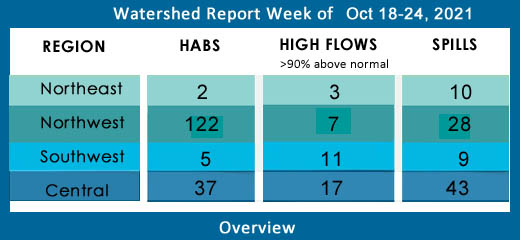
SEE BELOW FOR DETAILS

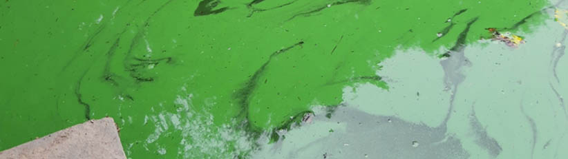
Image of Hemlock Lake, Genessee Watershed, credit: NYS HABS Notifications/CSLAP
Central NY Watersheds emptying into Atlantic Ocean at Long Island Sound
Mohawk River Watershed
The Mohawk River originates in the western Adirondacks and the Tug Hill Plateau and flows 140 miles to the east where it joins the Hudson River. Sections of the Mohawk River also serve as the New York State Barge (Erie) Canal.
Including Schoharie Creek, West Canada Creek, East Canada Creek; Hinkley Reservoir, Delta Reservoir, Peck Lake, Schoharie Reservoir; joins the Hudson River below Albany.
High Flows:
- Mohawk River below Delta Dam at Rome is flowing much above normal 211% at 700 cfs; at Cohoes is above 90th percentile, 392% above mean at 17,600 cfs
- Otsquago Creek at Fort Plain is flowing much above normal 313% above mean, 222 cfs
- West Canada Creek is flowing much above normal at Kast Bridge, 224% above mean, 2290 cfs
- East Canada Creek at East Creek is flowing much above normal, 279% above mean flow, 2250 cfs
- Schoharie Creek at North Blenheim is flowing much above normal, 256% above mean, 710 cfs; at Burtonsville is flowing much above normal, 306% above mean, 2580 cfs;
HABs: none reported
Spill Report
Montgomery County: none reported
Schoharie County: none reported
Upper Hudson River Watershed
The Upper Hudson River Watershed drains the south side of the Adirondack Mountains and flows south.
Including Sacandaga River, Schroon River, Indian River, Fish Creek, Hoosic River, Batten Kill, Great Sacandaga Lake, Indian Lake, Schroon Lake, Saratoga Lake
High Flows –
- Hudson River at Green Island is flowing much above normal, 221% above mean 25,700 cfs
- Sacandaga River at Stewarts Bridge near Hadley is flowing much above normal, 213% above mean 4050 cfs
- Batten Kill below Mill at Battenville is flowing much above normal, 205% above mean at 884 cfs
- Hoosic River near Eagle Bridge is flowing much above normal 336% above mean, 1960 cfs
HABs
Tomhannock Reservoir
- Oct 11 small localized bloom confirmed in Rensselaer County
Long Pond
- Oct 6 and Oct 8 two small localized blooms confirmed in Renssalaer County
Saratoga Lake – no new blooms reported, 3 previous blooms remain active
- Small localized bloom on the south end around Shore Ave and 6th confirmed Oct 5 in Saratoga County remains active
- Widespread/lakewide bloom confirmed mid-lake Oct 6 remains active
- large localized bloom confirmed Oct 5 off Manning Cove Road remains active
Galway Lake
- small localized bloom confirmed Oct 6 in Saratoga County remains active
Dead Lake
- Oct 11 small localized bloom confirmed mid-lake in open water in Washington County
Lake George - 1 New Bloom confirmed this week. 6 others remain active from last week
- Oct 10 a small localized bloom has been confirmed in Warren County, mid-lake, off Clay Island
- two small localized blooms confirmed Oct 5 and 6 at Assembly Point remain active this week; one on the east shore at the base of Assembly Point, the second is east of Assembly Point Road midway up the peninsula
- two blooms confirmed around Ripley Point remain active this week: one small localized bloom confirmed Oct 6, off the west shore between Heron Rd and Seneca Drive and one small localized bloom east of Cleverdale Rd;
- two small localized blooms confirmed Oct 6 and 8th remain active this week, east off Rockhurst Rd, at the base of Sheldon Point in Warren County
Spill Report
Saratoga County:
-Equipment failure in Waterford caused unknown amounts of hydraulic oil to be spilled in the soil 10/11/21, unresolved
-Equipment failure in Malta caused unknown amounts of motor oil to be spilled on an unknown resource 10/13/21, unresolved
-Equipment failure in Ballston Spa caused unknown amounts of unknown petroleum to be spilled in the soil 10/14/21, resolved 10/14/21
-Equipment failure in Clifton Park caused unknown amounts of transformer oil to be spilled in the soil 10/15/21, unresolved
Washington County:
-Tank Test Failure in Hudson Falls caused unknown amounts of gasoline to be spilled on an unknown resource 10/15/21
Warren County:
-Equipment failure in North Creek caused 5 gallons of transformer oil to be spilled in the soil 10/11/21, unresolved
-Traffic accident in Fort Ann caused unknown amounts of diesel and motor oil to be spilled on an unknown resource 10/12/21, unresolved
Lower Hudson River Watershed
The Lower Hudson Watershed begins where the Mohawk River joins the Hudson system at the Troy Dam and extends down to Manhattan. The lower end of the Hudson system, 153 miles, is technically a tidal estuary, not a river.
Rondout/Wallkill Rivers, Stockport/Kinderhook Creeks, Catskill Creek, Esopus Creek, Croton River; Ashokan Reservoir, Rondout Reservoir, New Croton Reservoir, Alcove Reservoir, Cross River Reservoir, Muscoot/Upper New Croton Reservoir
High Flows:
- Valatie Kill near Nassau is flowing much above normal, 459% above normal, 39 cfs
- Kinderhook Creek at Rossman is still flowing much above normal, 715% above mean at 1610 cfs
- Esopus Creek at Mount Marion is flowing much above normal, 456% above mean to 1130 cfs
HABs:
- Oct 13 Sagamore Lake widespread/lakewide bloom confirmed in Putnam County
- Oct 8 Snyder’s Lake widespread/lakewide bloom confirmed in Rensselaer County
Tomkins Lake small localized bloom confirmed Oct 5 in Rockland County
Unnamed water body reports a small localized bloom Oct 6 in Ulster County
Spill Report
Westchester County:
-Equipment failure in New Rochelle caused unknown amounts of #2 fuel oil to be spilled in the soil 10/11/21, unresolved
-Traffic accident in Harrison caused 70 gallons of diesel to be spilled in the soil 10/12/21, unresolved
-Unknown cause in Croton on Hudson caused unknown amounts of unknown petroleum to be spilled in the soil and ground water 10/12/21, unresolved
-Equipment failure in Mount Kisco caused unknown amounts of #2 fuel oil to be spilled in the soil 10/13/21, unresolved
-Equipment failure in New Rochelle caused unknown amounts of #2 fuel oil to be spilled in the soil 10/13/21, unresolved
Orange County:
-Equipment failure in Montgomery caused unknown amounts of transformer oil to be spilled in the soil 10/12/21, resolved 10/13/21
-Equipment failure in Chester caused unknown amounts of #2 fuel oil to be spilled in the soil 10/12/21, unresolved
-Equipment failure in Middletown caused unknown amounts of transformer oil to be spilled in the soil 10/14/21, unresolved
-Equipment failure in Tuxedo caused unknown amounts of #2 fuel oil to be spilled in the soil 10/15/21, unresolved
Putnam County:
-Other cause in Cold Spring caused unknown amounts of unknown petroleum to be spilled in the soil 10/14/21, unresolved
-Other cause in Brewster caused unknown amounts of #2 fuel oil to be spilled in the soil 10/14/21, unresolved
Columbia County:
-Equipment failure in Claverack caused 0.01 gallons of hydraulic oil to be spilled in the soil 10/12/21, unresolved
-Traffic accident in Hudson caused unknown amounts of gasoline to be spilled in surface water 10/12/21, resolved 10/18/21
-Equipment failure in Canaan caused 45 gallons of other material to be spilled on an unknown resource 10/13/21, unresolved
-Equipment failure in Chatham caused 6 gallons of hydraulic oil to be spilled on an unknown resource 10/14/21, resolved 10/18/21
Delaware River Watershed
The headwaters flow down from the Catskill Mountains into Delaware Bay/Atlantic Ocean. The watershed area includes East Branch Delaware River, West Branch Delaware River, Neversink River, Mongaup River, Pepacton Reservoir, Cannonsville Reservoir and Neversink Reservoir.
High Flows:
- East Branch Delaware at Downsville 372% above mean, 710 cfs; at Harvard 284% above mean, 883 cfs;
- West Branch Delaware River upstream from Delhi is flowing much above normal, 271% above mean at 324 cfs
- Neversink River at Neversink is flowing much above normal 281% above mean at 188 cfs
- Mongaup River at Mongaup is flowing above 90th percentile, 237% above mean at 557 cfs
- Trout Creek near Trout Creek is flowing above 90th percentile, 366% at 81 cfs
HABS:
Oct 12 Rio Reservoir small localized bloom confirmed in Sullivan County
Oct 13 Cannonsville Reservoir widespread/lakewide bloom confirmed in Delaware County
Morningside Lake widespread/lakewide bloom confirmed Oct 7 in Sullivan County
Lake Louise Marie large localized bloom confirmed in Sullivan County Oct 6 remains active on the west shore off Lakeshore Drive West;
widespread/lakewide bloom confirmed Oct 7 in Sullivan County south of Lake Louise Marie Rd remains active
an unnamed water body off State Route 28 south of Boiceville in Ulster County has a small localized bloom, reported Oct 6
Oquaga Lake small localized bloom confirmed in Broome County Oct 6 remains active
Spill Report:
Sullivan County:
-Equipment failure in North Branch caused unknown amounts of gasoline to be spilled on an unknown resource 10/11/21
-Unknown cause in Narrowsburg caused unknown amounts of raw sewage to be spilled into the air 10/11/21, unresolved
Delaware County:
-Equipment failure in Roscoe caused unknown amounts of #2 fuel oil to be spilled in the soil 10/12/21, unresolved
-Equipment failure in Sidney caused unknown amounts of #2 fuel oil to be spilled on an unknown resource 10/12/21, unresolved
-Equipment failure in Andes caused unknown amounts of #2 fuel oil to be spilled in the soil 10/15/21, unresolved
Ulster County:
-Equipment failure in Bearsville caused unknown amounts of #2 fuel oil to be spilled in the soil 10/14/21, unresolved
Housatonic River Watershed
A small portion of the headwaters of the Housatonic lie in eastern New York State. These waters drain the Taconic and Berkshire Mountains before joining the Housatonic and eventually emptying into Long Island Sound. Includes Tenmile River, Green River, Indian Lake, Swift/Crane Ponds
High Flow:
Housatonic and Green Rivers are flowing much above normal again this week, as noted in monitoring stations at Great Barrington, Vermont
All New York state side monitoring stations in Housatonic Watershed are registering flows below 90th percentile.
HABs: none reported
Spill Report:
Dutchess County:
-Deliberate cause in Hyde Park caused unknown amounts of unknown petroleum to be spilled in the soil and surface water 10/13/21, unresolved
-Equipment failure in Poughkeepsie caused 2 gallons of hydraulic oil to be spilled in the soil 10/13/21, resolved 10/14/21
Ramapo River Watershed
The northern headwaters of the Passaic basin lie within a small portion of southeastern New York State, including the Ramapo and Hackensack Rivers drainage areas. It is the smallest watershed in New York State. Including Ramapo River, Hackensack River, Greenwood Lake, DeForest Lake.
High Flow: all flows below 90th percentile
HABs: none reported
Spills Report:
Rockland County:
-Equipment failure in Haverstraw caused 10 gallons of hydraulic oil to be spilled in the soil 10/12/21, resolved 10/12/21
-Tank Test Failure in New City caused unknown amounts of #2 fuel oil to be spilled in the soil 10/12/21, unresolved
Atlantic Ocean/Long Island Sound Watershed
The Atlantic Ocean/Long Island Sound Watershed drains most of the New York City Metropolitan Area and all of Long Island. The drainage area includes all marine waters in New York Harbor, Long Island Sound, Block Island Sound, and along the South Shore of Long Island, and the fresh waters that drain into them.
Includes 1415 square miles of marine estuary waters, the Bronx River, Mamaroneck River, Mianus River, Peconic River, Kensico Reservoir, Lake Ronkonkoma.
High Flow: all flows below 90th percentile
HABs –
Oct 13 Agawam Lake widespread/lakewide bloom confirmed in Suffolk County; the widespread bloom confirmed Oct 5 remains active
Oct 14 Prospect Park Lake widespread/lakewide bloom confirmed in King’s County/Brooklyn
Oct 14 Long Pond widespread/lakewide bloom confirmed in Suffolk County
Oct 14 Wainscott Pond widespread/lakewide bloom confirmed in Suffolk County; the widespread bloom confirmed Oct 7 remains active
Oct 14 Great Pond, small localized bloom confirmed in Suffolk County
Indian Pond widespread/lakewide bloom confirmed Oct 5 in Bronx County remains active
Turtle Pond large localized bloom confirmed Oct 5 in Manhattan remains active
The Lake in Central Park widespread/lakewide bloom confirmed Oct 5 remains active – see above
Mill Pond (Watermill) widespread/lakewide bloom confirmed Oct 7 in Suffolk County remains active
Spill Report:
Kings (Brooklyn):
-Other cause in Brooklyn caused unknown amounts of other material to be spilled on an unknown resource 10/12/21, resolved 10/13/21
Queens County:
-Equipment failure in Maspeth caused 5 gallons of diesel to be spilled on an unknown resource 10/11/21, resolved 10/12/21
-Unknown cause in Long Island City caused 0.5 gallons of lube oil to be spilled on an unknown resource 10/14/21, resolved 10/14/21
-Human error in Maspeth caused 2 gallons of other material to be spilled on an unknown resource 10/14/21, unresolved
Nassau County:
-Equipment failure in Massapequa Park caused 1lbs of transformer oil to be spilled in the soil 10/11/21, unresolved
-Equipment failure in Franklin Square caused 40 gallons of #2 fuel oil to be spilled on an unknown resource 10/11/21, unresolved
-Equipment failure in Levittown caused unknown amounts of #2 fuel oil to be spilled in the soil 10/12/21, unresolved
-Equipment failure in Massapequa Park caused 4 gallons of #2 fuel oil to be spilled on an unknown resource 10/13/21, unresolved
Suffolk County:
-Equipment failure in Mastic caused 2 gallons of #2 fuel oil to be spilled in the soil 10/11/21, resolved 10/12/21
-Unknown cause in East Islip caused unknown amounts of unknown petroleum to be spilled on an unknown resource 10/11/21, unresolved
-Unknown cause in Medford caused unknown amounts of #@ fuel oil to be spilled on an unknown resource 10/11/21, unresolved
-Equipment failure in Northport caused 1 gallon of transformer oil to be spilled in the soil 10/15/21, unresolved
Richmond County: None reported
Bronx County:
-Unknown cause in the Bronx caused unknown amounts of unknown petroleum to be spilled on an unknown resource 10/11/21, unresolved
Northeast Watersheds– emptying into Atlantic Ocean via St. Lawrence River
Lake Champlain Watershed
The Lake Champlain Watershed drains the area between the Adirondack Mountains in northeastern New York State and the Green Mountains in northwestern Vermont.
Includes the Ausable River, Saranac River, Great Chazy River, Boquet River, Mettawee River, Ticonderoga Creek/Lake George, Lake George,
Upper Saranac Lake, Lower Saranac Lake, Lake Placid, Lake Champlain
High Flows: all systems flowing below 90th percentile
HABs: none reported
Spill Report:
Clinton County:
- Unknown cause in Plattsburgh caused unknown amounts of #2 fuel oil to be spilled in the soil 10/11/21, unresolved
Essex County:
-Unknown cause in Ticonderoga caused 50 gallons of diesel to be spilled on an unknown resource 10/12/21, unresolved
-Equipment failure in Ticonderoga caused 40 gallons of hydraulic oil to be spilled on an unknown resource 10/13/21, unresolved
-Traffic accident in Moriah caused 9lbs of transformer oil to be spilled in the soil 10/14/21, unresolved
-Equipment failure in Ticonderoga caused unknown amounts of water runoff to be spilled in the soil 10/14/21, resolved 10/04/21
St. Lawrence River Watershed
185 km of the St. Lawrence River catches the runoff from the northern and western Adirondack Mountains, drawing from portions of eight states, a combined area of 5600 square miles.
St. Lawrence Watershed collects the flow from eleven thousand miles of freshwater rivers and streams, including the Oswegatchie River, Raquette River, Saint Regis River, Grass River and Indian River; including Black Lake, Cranberry Lake, Raquette Lake, Tupper Lake and Long Lake. Densely forested woodlands, peatlands and areas of flat agricultural plains make up the natural surface water filtration system of this watershed area.
High Flows: all flows below 90th percentile
HAB’s
Silver Lake small localized bloom confirmed Oct 5 in St. Lawrence County remains active
Spill Report
Franklin County: none reported
St. Lawrence County:
-Housekeeping caused unknown amounts of siloxanes to be spilled on the soil and surface water 10/12/21, unresolved
Black River Watershed
Filters and drains most of Jefferson and Lewis Counties along with parts of Herkimer, Hamilton and Oneida Counties.
Major tributaries in the system include Moose River, Beaver River, Independence River and Deer River, Stillwater Reservoir, Fulton Chain of Lakes, Lake Lila and Big Moose Lake.
High Flows:
- Black River near Boonville is flowing much above normal this week, 343% above mean 2170 cfs
- Independence River at Donnattsburgh Road is flowing much above normal, 236% at 459 cfs
- Beaver River at Croghan is flowing much above normal, 174% above mean at 964 cfs
HABs –
Payne Lake small localized bloom confirmed Oct 6 in Jefferson County remains active
Spill Report :
Jefferson County:
-Equipment failure in Watertown caused 2 gallons of motor oil to be spilled on an unknown resource 10/11/21, unresolved
-Human error in Natural Bridge caused 100 gallons of waste oil to be spilled in the soil and impervious surface 10/12/21, unresolved
-Equipment failure in Wilna caused 8 gallons of diesel to be spilled in the soil 10/12/21, unresolved
-Human error in LeRay caused 2 gallons of jet fuel to be spilled in the soil 10/15/21, unresolved
Lewis County: none reported
Northwest Watersheds – empty into Atlantic Ocean via Great Lakes and St. Lawrence River
Lake Ontario and Minor Tributaries
This watershed includes the areas between the larger rivers that drain into Lake Ontario. It is divided into western, central and eastern sections that stretch all along the Lake Ontario Shoreline.
*Includes Salmon River Reservoir, Sodus Bay, North Pond, Irondequoit Bay and Perch Lake; Salmon River, Oak Orchard Creek, Irondequoit Creek, Sandy Creek
High Flows: all flows below 90th percentile
HABs:
North Sandy Pond large localized bloom confirmed Oct 8 in Oswego County remains active this week.
Little Sodus Bay small localized bloom confirmed in Oct 5 Cayuga County remains on the active list.
Spill Report
Orleans County: -none reported
Wayne County:
-Equipment failure in Williamson caused unknown amounts of diesel to be spilled on an impervious surface 10/12/21, resolved 10/14/21
-Human error in Ontario caused 1 gallon of motor oil to be spilled in the soil and surface water 10/12/21, resolved 10/19/21
Oswego County:
- An unknown amount of raw sewage was deliberately released from a residence in Hastings, 10/10/2021, resolved 10/12/2021
Niagara River/Lake Erie Watershed
The Niagara River drains an area encompassing more than 265,000 square miles in the north central United States and south-central Canada, including Tonawanda Creek, Cattaraugus Creek, Buffalo River; Attica Reservoir and Lime Lake.
High Flows: all flows are below 90th percentile
HABs:
- Oct 11 Ellicott Creek small localized bloom confirmed in Erie County
Hyde Park Lake, 2 small localized blooms confirmed Oct 7 in Niagara County remain active
Spill Report
Erie County:
-Human error in Tonawanda caused 10 gallons of hydraulic oil to be spilled on an impervious surface 10/11/21, unresolved
-Equipment failure in Buffalo caused 25 gallons of hydraulic oil to be spilled on an unknown resource 10/11/21, unresolved
-Equipment failure in Buffalo caused 1 gallon of diesel to be spilled in the soil 10/12/21, resolved 10/12/21
-Equipment failure in Getzville caused unknown amounts of transformer oil to be spilled in the soil 10/13/21, unresolved
-Equipment failure in Getzville caused unknown amounts of transformer oil to be spilled in the soil 10/13/21, unresolved
-Equipment failure in Buffalo caused 15 gallons of hydraulic oil to be spilled on an unknown resource 10/13/21, resolved 10/13/21
-Equipment failure in Buffalo caused 20 gallons of #6 fuel oil to be spilled in the soil 10/15/21
Niagara County: -none reported
Genesee River Watershed
Including: Conesus Lake, Silver Lake, Mount Morris Reservoir, Hemlock Lake, Honeoye Lake; Cassadaga Creek, Honeoye Creek, Oatka Creek, Black Creek
High Flows:
- Genessee River at Wellsville is flowing much above normal 182% above mean, 466 cfs; at Portageville 312% above mean at 2450 cfs; near Mount Morris is 350% at 4060 cfs; at Avon 273% above mean flow, 3380 cfs; Ford St Bridge at Rochester is flowing much above normal 209% above mean at 3630 cfs
- Conesus Creek is flowing high, 1247% above mean at 169 cfs;
- Canandaigua Outlet is flowing much above normal this week, 513% above mean and 366 cfs
HABs:
Oct 14-15 Hemlock Lake two widespread blooms and a large localized bloom reported by Citizens’ Statewide Lake Assessment Program in Livingston and Ontario Counties
- Widespread bloom confirmed off east shore, mid-lake Hemlock Canadice State Forest, south of the Livingston/Ontario County line
- Large localized bloom confirmed off the beach south of Hemlock Lake Park
- Widespread bloom confirmed in open water southwest of Hemlock Lake Park
Oct 14 Honeoye Lake open water bloom confirmed in Ontario County off Wilson Point; large localized bloom confirmed Oct 6 off Twin Bay Drive on the west side
Canandaigua Lake still hosting 33 HABs
- large localized bloom confirmed Oct 6 in Ontario County off State Route 21 at NYS Boat Launch
- small localized bloom confirmed Oct 6 at Granger Point in Ontario County
- large localized bloom confirmed Oct 6 south of Walton Point in Ontario County
- small localized bloom confirmed Oct 6 at Long Point in Ontario County
- large localized bloom confirmed Oct at Menteth Point in Ontario County
- large localized bloom confirmed Oct 6 on the west shore at County Road 16 north of Tichenor Point
- small localized bloom confirmed Oct 6, west shore at Country Road 16 north of above bloom
- open water bloom confirmed Oct 7 mid-lake from above bloom
- open water bloom confirmed Oct 7 off west shore near Butler Rd and County Rd 16
- large localized bloom confirmed Oct 6 off west shore north of above bloom
- large localized bloom confirmed Oct 6 off the east shore at Otetiana Point
- large localized bloom confirmed Oct 6 off the east shore at Nibawauka Beach
- large localized bloom confirmed Oct 6 off the east shore and Meadow View Drive
- small localized bloom confirmed Oct 7 off the east shore at State Rd 364
- widespread bloom confirmed Oct 7 off the east shore at Shoal Water Point
- large localized bloom confirmed Oct 6 off the east shore at Deep Run Cove
- two large localized blooms confirmed Oct 8, 14 off the east shore at Lake Drive and Clover Rd; Lake Drive and Fair Oaks Ave
- two large localized blooms confirmed Oct 6, 14 off the east shore at Old East Lake Road
- large localized bloom confirmed Oct 7 off the east shore at Arrowhead Dr
- small localized bloom and lakewide blooms confirmed Oct 14 off the east shore at County Rd 11 and Jones Rd
- large localized bloom confirmed Oct 6 off east shore at East Lake Rd
- open water bloom confirmed Oct 6 off the east shore south of above bloom, Yates County
- open water bloom confirmed Oct 6 mid-lake south of above, Yates County
- two small localized blooms confirmed Oct 10, 14 off east shore at Vine Valley Rd in Yates County
- two large localized blooms confirmed Oct 8, 14 off east shore south of Vine Valley Rd in Yates County
- open water bloom confirmed mid-lake west of South Hill in Yates County
- open water bloom confirmed mid-lake north of Sunnyside Point in Yates County
Irondequoit Bay small localized bloom confirmed in Monroe County Oct 5 remains active
Spill Report:
Livingston County: none reported
Allegany County:
-Equipment failure in Bolivar caused unknown amounts of kerosene to be spilled on an unknown resource 10/12/21, unresolved
-Unknown cause in Cuba caused unknown amounts of unknown petroleum to be spilled in the soil 10/13/21, unresolved
-Tank Test Failure in Cuba caused unknown amounts of gasoline to be spilled on an unknown resource 10/13/21, unresolved
Monroe County:
-Equipment failure in Brighton caused 0.5 gallons of transformer oil to be spilled on an unknown resource 10/11/21, unresolved
-Unknown cause in Greece caused unknown amounts of diesel to be spilled in the soil and surface water 10/11/21, resolved 10/13/21
-Traffic accident in Greece caused 45 gallons of diesel to be spilled on an unknown resource 10/12/21, unresolved
-Equipment failure in Rochester caused 30 gallons of diesel to be spilled on an unknown resource 10/12/21, resolved 10/13/21
-Equipment failure in Rochester caused 1lb of hydraulic oil to be spilled on an unknown resource 10/12/21, resolved 10/13/21
-Human error in Henrietta caused 20 gallons of gasoline to be spilled on an impervious surface 10/13/21, resolved 10/14/21
Genesee County:
-Equipment failure in Batavia caused 0.5 gallons of non PCB oil to be spilled in the soil 10/12/21, unresolved
-Human error in Corfu caused 10 gallons of diesel to be spilled on an unknown resource 10/14/21, unresolved
Wyoming County:
-Other cause in Bliss caused unknown amounts of water runoff to be spilled in the soil 10/15/21, resolved 10/15/21
Oswego River and Finger Lakes Watershed
Including Otisco, Skaneateles, Owasco, Cayuga, Oneida, Seneca, Keuka, Canandaigua and Canadice Lakes; Oneida River, Clyde River, Cayuga Lake Tributaries and Seneca Lake Tributaries
High Flows:
- Oswego River at Lock 7, Oswego is flowing much above normal this week 381%, flowing at 16,100 cfs
- Seneca River near Baldwinsville, flowing much above normal 338% above mean, flowing at 6970 cfs
- Onandaga Creek at Spencer St in Syracuse is flowing much above normal, 442% above mean, 526 cfs
- Oneida Creek at Oneida is flowing much above normal, 308% above mean, 333 cfs
HABs: HABS in Oswego River and Finger Lakes Watershed Remain High into the third week of October
Dr. John Halfman is a professor of Geolimnology and Hydrogeochemistry at the Hobart and William Smith Colleges in Geneva, NY. He has been studying Seneca Lake and others in the Finger Lakes region, where cyanobacteria growth patterns have been puzzling. Here is what he had to say about the profuse bloom activity in the 2021 season:
In a nutshell, HABs events favor:
- warm water: My data has shown that the Finger Lakes have been warming over the past few decades (global warming signal).
lots of sunlight - We always have sunny skies for a few days each week, especially in the summer. (Yet, when the lake was cool and the skies cloudy, we experienced significant events in Seneca.
- calm conditions: We enjoy calm conditions. Less wind and smaller waves due to its smaller size at Owasco helped the proliferation of HABs events in Owasco last year (2020).
- and lots of nutrients: The amount of nutrients available in the water, even in nearshore settings, is insufficient to support the amount of nutrients within the biomass of a typical bloom.
This raises the million-dollar question for the Finger Lakes. Where do the nutrients come from?
I’ve witnessed HABs oozing out of decaying macrophytes (nearshore weeds). It suggests that the extensive weed beds may provide sufficient nutrients. The weeds decay away during the late summer when blooms are most prevalent.
The sediments may also play a key, as decaying organic matter (algae and other organisms, even dead cyanobacteria), release nutrients to the sediments that are released during onshore wind events. The blooms developing on the next calm and sunny day. We spent a part of last summer analyzing the weed bed densities and concentrations of nutrients in the mud to confirm this hypothesis. I have grown HABs in the lab by placing recently dug sediments into a flask, adding distilled water, placing the flask on my sunny windowsill, and watching an event grow in the following week or so (in every flask).
The sediment nutrient pool may be why groundwater might play a role in HABs development. A mechanism is required to transport the sediment nutrients to the water column, e.g., waves, groundwater flow, etc.. Otherwise, typical lake floor chemistry locks the nutrients in the mud.
Intense rain events help. Intense rain events are becoming more frequent in the region (global warming signal), and preceded the first detection of HABs in certain lakes (e.g., Skaneateles). This past summer, the intense rains at Owasco Lake from the remnants of Fred preceded significant HABs events. The delivery of nutrients from the watershed to lakes is dominated by nonpoint sources, however, HABs events do not follow every rain event.
New Blooms Reported this week
Oct 10 Erie Canal two large localized blooms confirmed in Oswego County
Oct 11 Oneida small localized bloom confirmed in Oswego County
Oct 12 Lake Neatahwanta widespread/lakewide bloom confirmed in Fulton County
Oct 14 Panther Lake large localized bloom confirmed in Oswego County
Keuka Lake large localized bloom confirmed in Yates County remains active
Cayuta Lake small localized bloom confirmed in Schuyler County remains active
Seneca Lake, starting from northwest shore at Geneva Country Club and clockwise around the lake:
- Widespread/lakewide bloom confirmed off west shore at Geneva Country Club, Ontario County
- Large localized bloom confirmed off S Main Street Geneva, Ontario County
- Three large localized blooms and a small localized bloom confirmed off Lakefront Dr, Geneva, Ontario County
- Small localized bloom confirmed in Seneca County, north shore off Seneca State Park, Town of Fayette area
- Large localized bloom confirmed off east shore where West River Road merges with State Route 96A, Seneca County
- Small localized bloom confirmed off east shore, north of the intersection of East Lake Road and Edgewood Dr
- Small localized bloom confirmed off east shore near Willow Cove Lane, Seneca County, Town of Varick
- Small localized bloom confirmed off east shore north of Reeder Creek, Seneca County
- Large localized bloom confirmed off the east shore at Deal Road, Seneca County
- Large localized bloom confirmed off the east shore at E LakeShore Rd south of Kennedy Road
- Small localized bloom confirmed off the east shore at Sampson State Park, Seneca County
- Large localized bloom confirmed off the east shore at the south end of Sampson State Park, Seneca County
- Widespread/lakewide bloom confirmed off the east shore south of Bonavista State Golf Course, Seneca County
- Large localized bloom confirmed off the east shore between Andrea Drive and Mark Drive, Seneca County
- Large localized bloom confirmed off the west shore south of Baskin Point, Yates County
- Large localized bloom confirmed off the west shore between Jared Rd and Owego Rd, Yates County
- Large localized bloom confirmed off the west shore off Long Point Cove Rd, Yates County
- Large localized bloom confirmed off the west shore at Dresden, Yates County
- Large localized bloom confirmed off the west shore and Arrowhead Beach Road, north of the Town of Torrey, Yates County
- Large localized bloom confirmed off the west shore near the south end of Anthony Beach Rd, Yates County
- Small localized bloom confirmed off the west shore south of Serenity Road. Yates County
- Large localized bloom confirmed off the west shore at Angus Rd, Yates County
- Large localized bloom confirmed off the west shore north of Angus Rd, Yates County
- Widespread bloom confirmed off the west shore, off Old State Road, Yates County
- Widespread bloom confirmed off the west beach between Locust Grove and Oak Tree Drive
- Large localized bloom confirmed off the west shore off S Kashong Dr, Yates County
- Large localized bloom confirmed off the west shore near the Kashong Recreation Club, Ontario County
- Large localized bloom confirmed off the west shore north of Kashong Recreation Club, Ontario County
- Large localized bloom confirmed off the west shore, north of Reed Point, Ontario County
- Large localized bloom confirmed off the west shore at North White’s Point, Ontario County
- Small localized bloom confirmed off the west shore at Clark’s Point, Ontario County
Cayuga Lake: from the northern tip of the lake, to the east shore and clockwise
- Large localized bloom confirmed at northeast shore, off State Route 90 N in Cayuga County
- Widespread/lakewide bloom confirmed at northeast shore off State Route 90 N in Cayuga County
- Small localized bloom confirmed in Cayuga County, off the east shore at Lake St, Cayuga
- Two Large localized blooms confirmed off the east shore near Lower Lake Road north of Davis Point Rd, Cayuga County
- Widespread/lakewide bloom confirmed off the east shore, south of Hibiscus Point, Cayuga County
- Small localized bloom confirmed off the east shore off S Cayuga St and Centre St, Union Springs, Cayuga County
- Widespread/lakewide bloom confirmed off the east shore at Levanna Rd, Cayuga County
- Large localized bloom confirmed off the east shore at Main St and Dublin Hill Road, Aurora, Cayuga County
- Large localized bloom confirmed off the east shore north of the King Ferry Golf Course
- widespread bloom confirmed off the east shore near the south end of Powers Rd, Atwater, Cayuga County
- large localized bloom confirmed off the east shore north of Morrow Creek, Tompkins County
- widespread/lakewide bloom confirmed east shore, south of Ladoga Park Rd, Tompkins County
- large localized bloom confirmed off east shore, near East Shore Drive in Cayuga Heights, Tompkins County
- widespread/lakewide bloom confirmed east of Taughannock Blvd, south of Indian Creek outlet in Tompkins County
- large localized bloom confirmed off Taughannock Blvd south of Gorge Rd in Tompkins County
- large localized bloom confirmed in Seneca County, south of the outlet of Trumansburg Creek on the east side of the lake
- large localized bloom confirmed in Seneca County, off Little Point Road just south of Green Lane, west side of the lake
- widespread bloom confirmed on the west side of the lake in Seneca County, south of Deerlick Springs Rd
- large localized bloom and lakewide blooms confirmed on the west shore, Seneca County between Blue Heron Point and Lakewood Dr
- small localized bloom confirmed off the west shore, north of Hicks Gully, Seneca County
- widespread bloom confirmed off the west shore, off State Route 89, Seneca County
- widespread bloom confirmed off the west shore, off Parker Rd South, Kuneytown, Seneca County
- large localized bloom confirmed in Cayuga County (east side) off Fire Lane 6
Owasco Lake:
- small localized bloom off north end of the lake, in Cayuga County
- small localized bloom off the east shore at Waters Edge, Cayuga County
- two large localized blooms off the west shore at Lehigh Valley and Fire Road 19, Cayuga County
- large localized bloom confirmed off the west shore at Fire Road 26, Cayuga County
Skaneateles Lake:
- small localized bloom confirmed at the north end of the lake, between Shotwell Park and Thayer Park, Onandaga County
- small localized bloom confirmed off the east shore, between Coon Hill Rd and Collard Rd, Onandaga County
- small localized bloom confirmed off the east shore, south of Collard Rd, Onandaga County
- small localized bloom confirmed off the east shore, north of Hall Creek, Onandaga County
- large localized bloom confirmed off the east shore, south end of the lake off Spafford Landing Rd, Onandaga County
- small localized bloom confirmed off the west shore, off West Lake Rd at Lacy Rd, Onandaga County
- large localized bloom confirmed off the west shore, between Fire Lane 14 and Fire Lane 17, Onandaga County
- large localized bloom confirmed off west shore between Fire Lane 8 and 9, Onandaga County
- small localized bloom confirmed off west shore at Mile Point, Onandaga County
Spill Report:
Seneca County: none reported
Onondaga County:
-Deliberate actions in Dewitt caused 5 gallons of motor oil to be spilled on an unknown resource 10/11/21, unresolved
-Other cause in Baldwinsville caused 20 gallons of other material to be spilled in the soil 10/111/21, resolved 10/12/21
-Traffic accident in Syracuse caused 5 gallons of non PCB oil to be spilled in the soil 10/11/21, unresolved
-Equipment failure in Camillus caused 20 gallons of hydraulic oil to be spilled on an unknown resource 10/12/21, resolved 10/12/21
Schuyler County:
-Traffic accident in Watkins Glen caused 30 gallons of transformer oil to be spilled in the soil 10/14/21, unresolved
Yates County: none reported
Ontario County:
-Unknown cause in Honeoye caused unknown amounts of unknown material to be spilled on an unknown resource 10/15/21, resolved 10/15/21
Southwest Watersheds – Allegheny, emptying into Gulf of Mexico via Ohio River/Mississippi River; Chemung and Susquehanna emptying into Atlantic Ocean via Chesapeake Bay
Allegheny River Watershed (flowing west into Ohio River system)
Including Allegheny River, Chadakoin River, Conewango Creek, Canaseraga Creek, Cassadaga Creek, Olean Creek, Great Valley Creek, French Creek, Allegheny Reservoir, Chautauqua Lake
High Flows:
- Chadokoin River flowing much above normal this week, 309% above mean flow at 713 cfs
HABs: Chautauqua Lake still Blooming, 5 New HABs reported this week
- large localized bloom near Celoron has been confirmed Oct 5 in Chautauqua County remains active
- widespread/lakewide bloom is confirmed Oct 5 in the center of the lake north from the point at Loomis Bay Road, Chautauqua County
- large localized bloom confirmed Oct 7 in the bay between Celoron and Lakewood in Chautauqua County remains active
- large localized bloom confirmed Oct 7 mid-lake between Long Point State Park on the north and Willow Run Golf Course on the south, Chautauqua County remains active
Spill Report:
Cattaraugus County: -none reported
Chautauqua County:
-Equipment failure in Hanover Rd caused 20 gallons of other material to be spilled in the soil 10/11/21, resolved 10/11/21
Chemung River Watershed
The Chemung River flows across the western portion of Southern Tier of New York State before joining the Susquehanna River and eventually emptying into the Chesapeake Bay.
Including Chemung River, Cohocton River, Tioga/Canisteo River; Lamoka Lake/Mill Pond, Waneta Lake, Almond Lake
High Flows:
- Canacadea Creek near Hornell is flowing much above normal, 171% above mean, 84 cfs
- Canisteo River at West Cameron is flowing much above normal, 198% above mean, 401 cfs
- Cohocton River near Campbell is flowing much above normal, 330% above normal, 740 cfs
- Tioga River near Erwens is flowing much above normal, 170% above mean, 1700 cfs
- Chemung River at Corning is flowing much above normal, 197% above mean, 2150 cfs; at Chemung is flowing much above normal, 233% above mean, 2730 cfs
HABs: no active blooms
Spill Report:
Chemung County:
-Equipment failure in Elmira caused 10 gallons of regulator oil to be spilled on an impervious surface 10/13/21, unresolved
-Equipment failure in Pine City caused 500 gallons of stormwater to be spilled in the soil 10/13/21, resolved 10/14/21
Steuben County:
-Equipment failure in Painted Post caused 12.4 gallons of other material to be spilled on an unknown resource 10/11/21, unresolved
-Equipment failure in Arkport caused 80 gallons of #2 fuel oil to be spilled on an unknown resource 10/12/21, resolved 10/14/21
-Human error in Painted Post caused 0.25 gallons of ethylene glycol to be spilled on an unknown resource 10/13/21, resolved 10/14/21
Susquehanna River Watershed
The Susquehanna River drains 27,500 square miles covering large parts of New York, Pennsylvania and Maryland before emptying into the Chesapeake Bay.
Including: Chenango River, Tioughnioga River, Unadilla River, Owego Creek; Otsego Lake, Canadarago Lake, Whitney Point Lake/Reservoir
High Flows :
- Susquehanna River at Unadilla is flowing much above normal, 367% above mean flow at 3840 cfs; at Conklin is 319% above mean at 7940 cfs; at Vestal 463% above mean at 14,400 cfs; at Waverly flowing much above normal 318% above normal 16,000 cfs
- Chenango River at Sherburne is flowing much above normal, 448% above mean at 1120 cfs; at Greene is flowing high, 629% above mean, 2290 cfs; near Chenango Forks up 387% above mean at 5900 cfs;
- Otselic River at Cincinnatus is flowing much above normal, 338% above mean at 585 cfs
- Tioughnioga River at Cortland is flowing much above normal, 366% above mean at 1020 cfs
- Fall Creek near Ithaca is flowing much above normal, 199% above mean at 257 cfs
HABs –
Guilford Lake large localized bloom confirmed Oct 8 in Chenango County remains active
Spill Report
Broome County:
-Traffic accident in Chenango caused unknown amounts of diesel to be spilled on an unknown resource 10/14/21, unresolved
-Human error in Union caused unknown amounts of gasoline to be spilled on an unknown resource 10/14/21, unresolved
Chenango County:
-Unknown cause in Chenango Forks caused unknown amounts of unknown material to be spilled in the soil 10/12/21, unresolved
Cortland County: none reported
Otsego County: none reported
Tioga County: none reported
Report Key:
High Flows: WTNY reports systems flowing more than 90% over mean flow rate, categorized as “much above normal” and “high”, based on USGS WaterWatch real time streamflow
Visit USGS WaterWatch for real time stream flows.
See also, National Weather Service high water terminology here https://www.weather.gov/aprfc/terminology
HABs – reporting confirmed hazardous algal blooms (cyanobacteria) confirmed as active on NYS HABs Notifications
Spills Report– hazardous materials spill incidents by county, listed in the pertinent watershed, as appearing in the NYS Environmental Sites Database, Spill Incidents Database as records are uploaded
See Watershed Basics Glossary for details on each report.
|